Clackamas County uses MapObjects to build an Enterprise Desktop GIS with Internet Capability
ABSTRACT
Bringing GIS data, legacy system data, imagery and mission critical data together in one easy to use interface that can be used by County staff and the public: Clackamas County with the assistance of GeoNorth Inc. has constructed a MapObjects-Visual Basic interface to seamlessly and effortlessly access GIS, tabular and image data. Upon completion of the desktop/customer counter interface, Clackamas County Utilities then deployed the "MoClack" application onto the county's Intranet and external web site.
The Clackamas County "MoClack" application uses MapObjects and Visual Basic to bring together a wide array of GIS data into an easy to use interface. Examples of data include 127,000+ parcel lots with assessor records, rivers, wetlands, flood zones, building permits, zoning, soils, district boundaries, topography (10ft/2ft), 3000+ taxmap images, sanitary sewer customer data, sanitary sewer system, 2000+ sanitary asbuilt images and digital ortho photography at three different pixel resolutions. This application runs on a variety of hardware from 486/66 to Pentium Pro's running Windows NT. All data is available via a 10base T switched network as well as over the Intranet/Internet. Clackamas County Utilities uses MoClack to administer daily customer service, complaint tracking, planning and research. The amount of time required to compile GIS and other data into meaningful decision support information has been drastically reduced, yielding tangible savings. Engineers, technicians, office staff and citizens have finally been able to access the enormous amounts of data the County has invested in over the years. GIS has never been easier or faster.
INTRODUCTION
Clackamas County Department of Utilities implemented a GIS plan in 1995, with the vision of developing an enterprise wide GIS system that would allow engineers, technicians, field crews and customers access to GIS and legacy database systems. The department maintains and routinely utilizes various data such as hydraulic model information, asbuilt drawings, paper maps and a Unisys based billing system. Other vital databases such as parcel lot coverage’s, streets, zoning and various environmental layers are maintained by Clackamas County GIS. This allowed the Department of Utilities to focus on collection and creation of data specific to the Utilities Department. Over the next 2 years the Department of Utilities has built an enterprise wide GIS application with Internet capability that surpassed all projections of speed, access to data and ease of use.
Building a complete sewer line coverage in ArcInfo
The Department's first goal was to convert all sanitary sewer paper maps and tabular data into a complete ArcInfo coverage for the County. A map drawn in 1984 depicting the location of sanitary sewer lines was scanned and vectorized. The .dxf file was then projected in to the appropriate coordinate system and rubber sheeted to fit the existing parcel base. Technicians used AutoCAD and asbuilt drawings to draft the new sewer lines using the parcel base as a reference for location. The Department maintains a unique manhole numbering scheme for all sanitary sewer structures. This id number was stored as an attribute in an AutoCAD block. The drafting work was completed in approximately 8 months. While the drafting was being completed, database design and conversion work started using a dbase file that was maintained to represent the entire sewer system for use in a hydraulic model. Because of a limitation in the hydraulic model, manhole id's were limited in size. An arbitrary number was generated for use in the hydraulic model. Paper indexes were maintained to provide a reference between the assign arbitrary number and the actual manhole id. These indexes were entered into Microsoft Excel for later database conversion. The data format of the hydraulic model provided a framework for the collections system with upstream and down stream manhole id’s and associated attribute information such as inverts, rim elevations, pipe lengths and diameters. Once the AutoCAD drafting was complete, the blocks were exported into an ASCII file containing x, y coordinates and manhole id’s. The three database models were then imported into Microsoft Access for processing. First the arbitrary numbers in the hydraulic database were replaced with the real manhole numbers from the indexed sheets. Fields were then added for the x and y coordinates representing up and down stream manholes. A join was used to populate the corresponding manholes with the appropriate coordinates.
With the assistance of County GIS, an AML was written to read the dbase file into ArcInfo and construct a line coverage using the up and down stream coordinates as the nodes for the linework. This produced a line coverage with attributes and flow direction for the entire system. Next, the AML built nodes and using a cursor processed each node to identify all incoming and outgoing lines, populating the node items with correcting invert elevations for all connections to the manhole. A subset of the AML is used to maintain the sewer coverage. This AML reads in new system via the original database design and appends and processes the lines and nodes to build a complete coverage.
The Department of Utilities invests in Image Data
In 1995, color digital ortho photography was purchased for the entire service area for the Department. The resolution for the orthos is 1.3 foot pixels in 24-bit color. Photos were converted to 8 bit color and sub-sampled within ArcInfo GRID, to produce more application friendly files with resolutions of 4 and 10 foot pixels. These photos are stored online for use in ArcInfo and ArcView.
All sanitary asbuilt drawings were microfilmed and scanned and a database was constructed with fields that contained the manhole number and file name of the asbuilt image.
Applications were written to provide user access to these images of the network. This was the first application that provided image data to users within the Department. Interest in this new way of accessing and printing the asbuilt drawings grew extremely fast and the necessity to provide more maps, drawings and documents in this manner became a priority.
The Department of Utilities also uses tax assessor maps on a daily basis. These tax map mylars are maintained for the entire county by the Assessor's office. All new subdivisions and partitions are drafted onto mylars by draftsmen using pen and ink. These mylars are then copied and distributed to 7 different locations throughout the County. The Department had the taxmaps microfilmed and scanned by a local company. Over 3000 images were then placed on line and another interface was written to gain access to these images.
Designing a GIS interface to provide access to GIS, tabular and image data.
The goal of the Department of Utilities was to create a common user interface that would allow easy access to a wide array of geographic, tabular and imaged data. The requirements that needed to be satisfied included speed, ease of use, minimal hardware requirements, low software cost per client and the ability to expand the system for future applications. ArcView was originally specified as the platform of choice for this project.
GeoNorth, Inc. a regional GIS, database and internet consulting firm introduced Clackamas County to MapObjects prior to its commercial release. GeoNorth, Inc. is routinely selected by Esri to participate in its beta software programs, and as such was well positioned to advise Clackamas on strategy and implementation of this new technology. Additionally, GeoNorth's ability to demonstrate a high performance, robust and easy to use demo application compelled Clackamas County to consider MapObjects as an alternative to ArcView.
Clackamas County's interest in MapObjects was further fueled by presentations and product announcements at the 96’ Esri Conference in Palm Springs; and by the end MapObjects seemed to satisfy the requirements that the development team had set for this project. From an implementation perspective, the programming environment of choice was Visual Basic, due to the County's standardization on Microsoft products and Esri's support for this tool. Based on the success of GeoNorth's prototyping efforts and the desire by Clackamas County to rapidly deploy the application, a contract was awarded to GeoNorth to begin work.
The application that the Department envisioned involves various tax assessor and land information that could be used by other County Departments. A joint development between the Department of Utilities and Clackamas County Planning would allow the development of a common interface and would avoid duplication of services. Budgets provided by the two Departments were combined to maximize the amount of functionality that could be developed.
GIS coordinators from the Department of Utilities and Clackamas County GIS developed the design, functionality and data that were used in MoClack. A list of GIS coverage’s, data and images that would become available through this interface was compiled. Functionality and workflow diagrams were constructed and utilized throughout the development. Functionality implemented within the moClack application includes:
Taxlot Information
Utilities Information
Map Making
Working with GeoNorth, Visual Basic forms were designed and a file folder type interface was chosen.
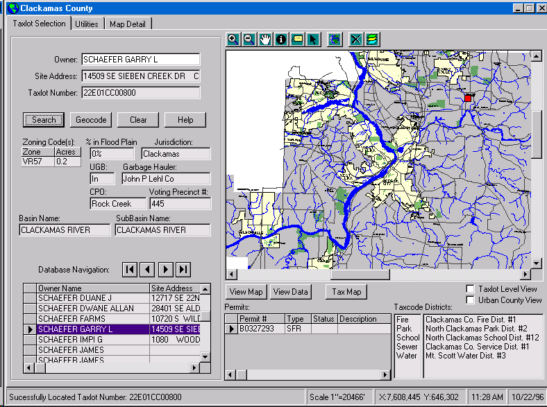
The figure above is the Tax Lot selection screen. The user can query by Owner, Site Address, Tax Lot number or Geocode the address. Once the query is completed (over 150,000 records in 2 seconds) the form is populated with the corresponding information. A red dot is placed on the map depicting the location of the parcel selected. 7 point in polygon operations are performed to produce the results that populate the Jurisdiction, UGB (urban grown boundary), Garbage Hauler, CPO (community planning organization), Voting precinct #, Basin and SubBasin name fields. Partial searches by name, address or taxlot number, results in a scrolling list that can be navigated and selected. Building permit information is displayed as well as all relative taxcode districts. Depressing the View Data button results in the following screen.
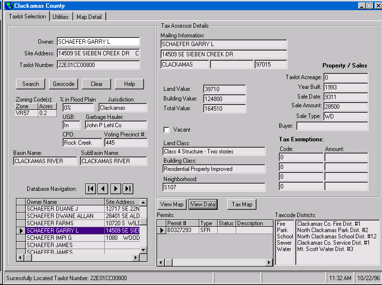
The map display is replaced with more tabular data from the assessor database. By checking the Taxlot Level View box the map is updated to view the selected parcel.
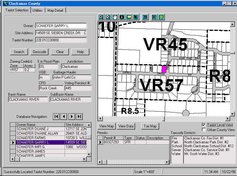
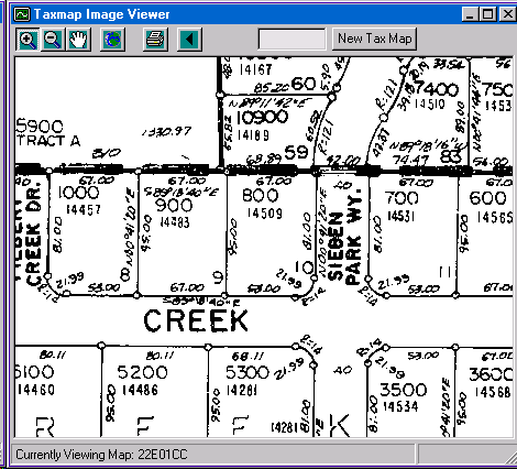
The selected parcel is depicted in pink and zoning boundaries are displayed. Depressing the Tax Map button displays the following window that can be paned, zoomed and printed.
Moving to the Utilities tab the form is updated to produce another interface to interact with Department of Utilities customer and collection system data.
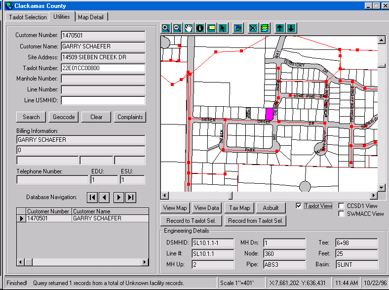
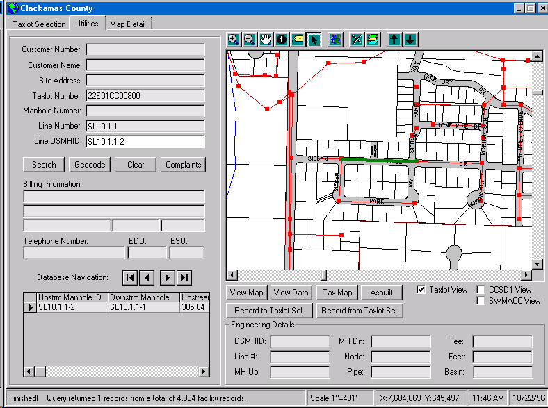
Information that can be queried upon includes customer number, name, address, taxlot number, manhole and sewer line numbers. All information from the customer database is displayed. Record navigation between the Taxlot selection screen and the Utilities screen, is provided by two buttons that transfer taxlot numbers from one screen to another. Queries are automatically executed and the appropriate screen is updated. Graphic selection is available on both screens by simply selecting the parcel or facility on the map. Selecting a manhole or sewer line results in a screen update depicted in the following figure.
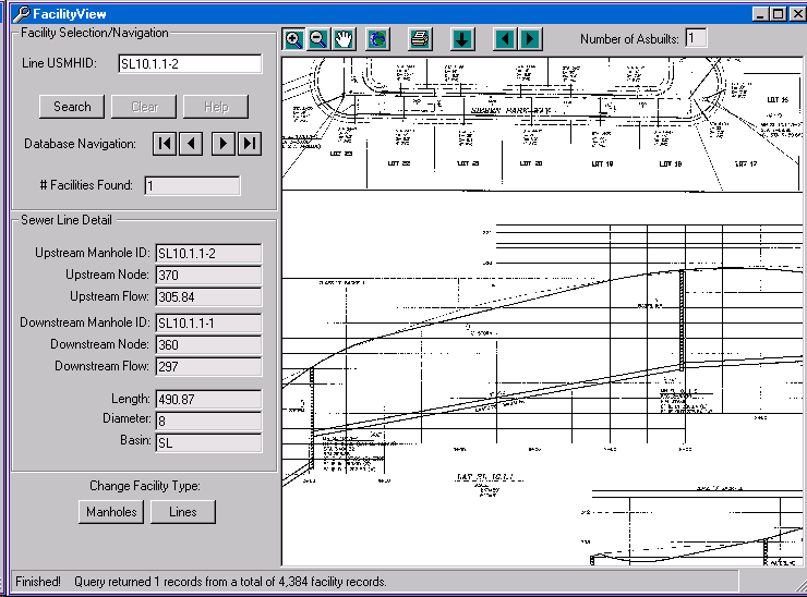
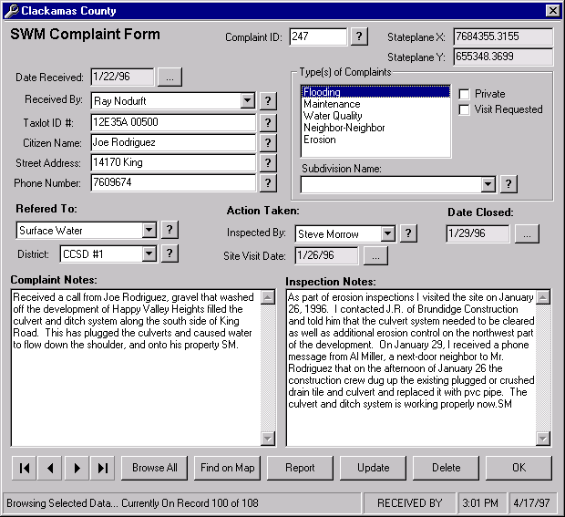
Once a facility is selected the Asbuilt button may be depressed to reveal the following screen.
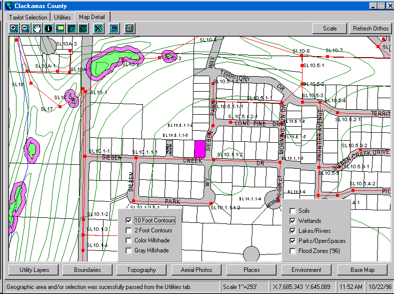
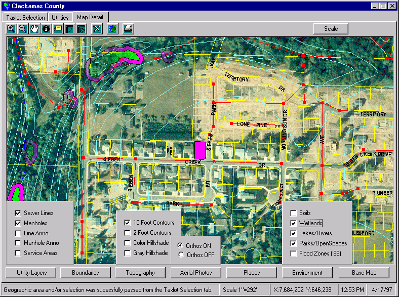
The Map detail screen allows the user to interactively display numerous layers and ortho photos to produce a cartographic map that can be printed. The follow screen represents the interface for making such a map.
The level of functionality that is currently designed into this application is quite substantial, and additional uses for the MoClack interface have been identified. County and local jurisdictions have expressed extreme interest in making it available for use. The applications design allows additional functionality to be incorporated into the MoClack interface. This Initial development was completed in approximately 4 months and distribution to the desktop was immediate.
The system had been designed to be modular and the addition of new functionality is inevitable. The Department of Utilities proceeded immediately to develop a Customer complaint tracking system within MoClack. The Department designed the necessary interface and functionality and again contracted GeoNorth, Inc. to construct the necessary VisualBasic/MapObjects module to add to the existing MoClack application. Development and testing occurred over the next month and a working application was brought on line within 7 weeks.
The following screen allows the user to record the necessary data about the complaint with drop down menus and pick lists. Two memo fields are available to record the specific conversation between the customer and staff person logging the complaint. Once the inspector name is chosen, an email notifying the individual of the assigned complaint is sent. This form is used to track the complaint from start to finish and allows anyone in the Department to view the status of the complaint from their workstation.
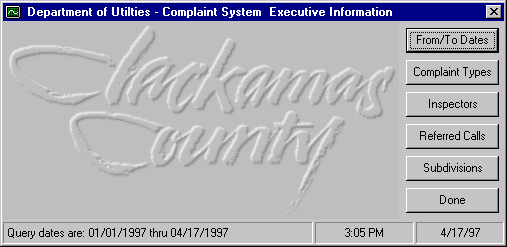
Included with the complaint system is an Executive Information System. This simple to use interface allows managers to easily generate reports on the status of the complaint process. The result is more efficient staff planning and work load distribution.
MoClack Goes Intranet and Internet
The response to this new GIS application has been overwhelming. Other county agencies, cities, developers, contractors, engineers, environmentalists and citizens are now requesting access to the application. Due to the large amount of data and the need to be hosted on an NT or windows 95 machine, wide area network deployment would be difficult. The obvious solution was to Internet enable MoClack. Using Esri’s MapObjects Internet Map Server, the Department of Utilities decided to leverage GeoNorth, Inc.'s expertise with development and internet tools as well as success on the existing MoClack application, to build an web-based version of MoClack.
The goal of this project is to provide as much MoClack functionality as possible within the context of a web browser. This provides an unprecedented level of independence from the issues of hardware/software platform, software deployment, software updates, data distribution and low bandwidth environments.
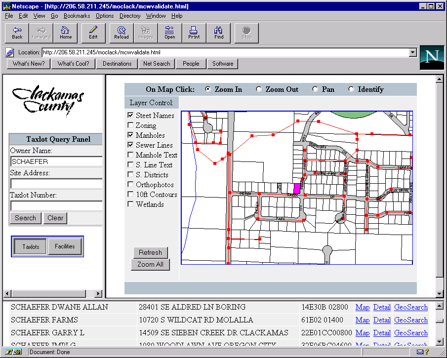
The initial interface relies almost exclusively on HTML and server side query tools; with a sprinkling of Javascript where necessary. Longer term plans call for additional use of Java to boost the level of interaction and graphic feedback. The first screen allows pan, zoom and graphical identify on parcel and facility layers within Clackamas County. The left-hand side provides a query panel by which the user may query for assessor or facility themes. Once a query is made all results are returned to a scrolling list in the bottom frame.
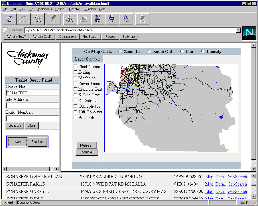
The hypertext next to each record produces three more functions. By selecting the Map link, the map is updated to show the selected feature. The figure below depicts the result.
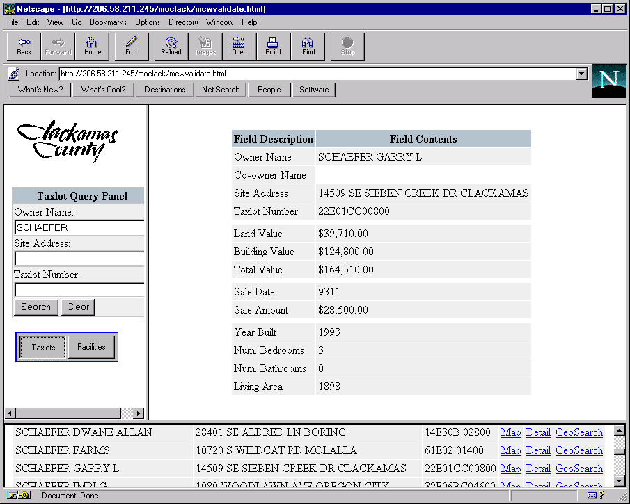
The hypertext Detail returns tabular information associated with the selected feature. All related information including sanitary customer information will be displayed in this manner. Also, the ability to print this information directly from the Browser will be available.
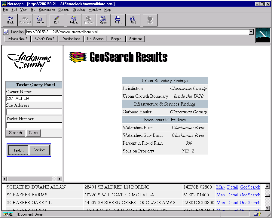
The third hypertext GeoSearch completes 7 spatial operations (point in poly or poly in poly) and returns the results in table form.
Conclusion
The Department of Utilities in conjunction with GeoNorth, Inc. have architected a powerful enterprise wide interface for delivering geographic, tabular and image data. The successful development with MapObjects has sparked tremendous interest in GIS within the County. Tangible gains in productivity and the inclusion of GIS in the decision support process have made this project a resounding success. Now, with the addition of a web based front end, tools and data can be made available to remote sites. Please visit our site on the WWW at
http://www.co.clackamas.or.us/ and proceed to the Department of Utilities link.
Acknowledgements
Mike Quetel, GeoNorth Inc. for ingenious and super human programming skills.
Dave Figueroa, Clackamas County GIS, co-developer and land base data support.
Rick Schulte GIS Coordinator, Clackamas County Department of Utilities 16770 S.E. 82nd Dr. Suite 200 Clackamas OR 97015 Telephone (503) 557-6462, Fax (503) 557-6496
ricks@utilpo.co.clackamas.or.us
Mike Quetel Senior GIS Analyst, GeoNorth, Inc. 921 SW Washington Suite 316 Portland, OR 97205 Telephone (503) 827-0827, Fax (503) 827-0735
www.geonorth.com
mquetel@geonorth.com