FLOOD WATCH
GIS Based Management System for Flood Forecast Applications
Kjelds, J.T. and Jørgensen, G. H.
Danish Hydraulic Institute, Agern Alle 5, DK-2970 Hørsholm, Denmark
INTRODUCTION
Many regions through out the world have experienced severe river flooding during the recent years. The flood has resulted in loss of life, damage to property, crops and had negative impacts on human welfare. Recent floods in large river systems throughout the world have arisen the awareness of responsible river authorities about the urgent need for an integrated Geographical Information Systems (GIS) based tool that will enable them to forecast flood conditions and manage the river environment.
Integration of numerical modeling tools with GIS greatly enhances the presentation and interpretation of the vast amount output from numerical models. Many mathematical models are spatial analysis tools which require detailed inputs. GIS is ideally suited for retrieval, preprocessing and analysis of various spatial model data.
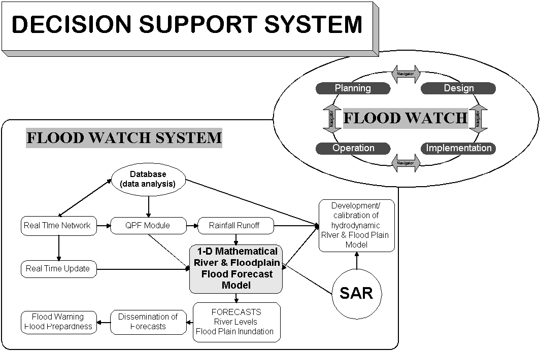
Merging the 1-Dimensional MIKE 11 river modeling system with GIS technology integrates an accurate and advanced mathematical modeling tool with a spatial analysis tool. The derived holistic approach incorporates also advanced time series analysis tools and extreme value statistics with GIS. The integrated system makes it ideally suited as a core element in a "Decision Support System" which can be efficiently applied for all aspects of Flood Plain and River Basin Management.
The MIKE 11 Flood Watch system integrates databases, the mathematical river models MIKE 11, pre-and post processing tools, etc. in an ArcView GIS environment.
In order to study and predict flooding in Bangladesh, detailed and extensive MIKE 11 flood forecast models have been developed and applied at the country’s Flood Forecasting and Warning Centre (FF&WC). In 1995 DHI was awarded a project for the expansion of the flood forecasting and warning services in Bangladesh. The new project, with a 3-year implementation period, aimed to expand the number of forecast points and increase further the accuracy of the models. In addition, the existing Flood Forecast system has been entirely replaced by the MIKE 11 Flood Watch system
The MIKE 11 DSS Framework
Combining advanced flood modelling with a GIS enables users and decision makers at various levels to investigate and assess proposed flood mitigation options and preparing environmental impact assessments. The tasks encompassed in flood management are not static but are usually of a very iterative nature. Related to present needs and future requirements the processes of flood management often develops following a cyclic pattern.
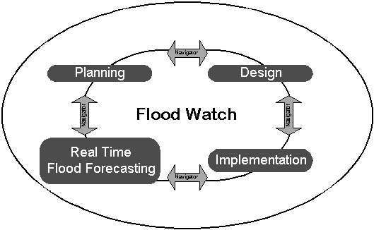
The Flood Watch System is the core in the Flood Management Cycle. The GIS based system makes it ideal as a key component in a Spatial Decision Support System.
The integrated model approach is well suited for application at different stages of the frequently composite and complex tasks of flood management. MIKE 11 and the MIKE 11 GIS interface finds its natural application at the planning, design, implementation and operation levels.
In the planning and design phase, the MIKE 11 system is a valuable tool for determining civil works design criteria, designing flood control and drainage structure operation rules, and providing inputs to flood preparedness programmes.
At the implementation stage, MIKE 11 may be useful for a range of needs from scheduling flood prone construction works to a flood preparedness training aid.
The on-line monitoring and operation naturally succeeds the implementation application. Close supervision, control and the ability to initiate emergency relief requires that the developed MIKE 11 application is linked to a real-time reporting telemetry system. With the real-time linkage established, MIKE 11 can be applied on an operational basis for real-time flood forecasting, flood inundation mapping and eventually as a emergency response tool.
THE MIKE 11 FLOOD FORECAST MODEL SYSTEM
The real-time flood forecasting system MIKE 11 FF is a part of the general MIKE 11 modelling system, which is a professional engineering software package for the simulation of flows, water quality, and sediment transport in rivers, channels, irrigation systems, and other water bodies. MIKE 11 is a dynamic, generic windows based modelling tool for the detailed design, management, and operation of both simple and complex river and channel systems.
The Flood Forecast module has been developed to satisfy the requirements of a modelling system to be used in real-time operation, namely a quick and user-friendly data management system and a modelling system which can transfer the real-time information on rainfalls, water levels, discharge and reservoir operation into forecasts of river flows and water levels.
The model system is integrated into a GIS through the Flood Watch interface. The Flood Watch interface allows users to carry out all forecasting activities, ranging from telemetric data collection through to model simulations and production of flood maps from a single consistent user interface.
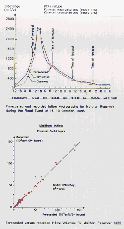
Transfer of flood modelling technology to Central Water Commission, Government of India, (CWC) was initiated in 1981 and continued in different phases for a period of 11 years. The main objective was upgrading of CWC capabilities in flood forecasting and planning of flood control measures. The system It was made operational in 1985 for prediction of inflow to the several reservoirs. The reliability and accuracy of the forecasts have from the beginning enabled reservoir operations to a higher level and thus significantly increased the amounts of water available for irrigation and other uses.
The MIKE 11 FF module includes the following components:
The MIKE 11 FF module is dedicated to minimise the amount of information required to be given by the operator in the daily forecast routine. The spatial inundation model allows for rapid and visual dissemination of flood warnings. Such a module is ideally suited for real-time applications, where reliability and fast performance are crucial. The MIKE 11 FF can be used in connection with either a manually based or a fully automatic data collection and processing system.
FLOOD WATCH SYSTEM
Flood Watch is a framework for MIKE 11 Flood Forecast applications, the database part is designed for efficient storage, fast retrieval and display of large amounts of data. The Flood Watch interface serves as the central manager for model data and acquisition of real time data. Tools are also available for estimation of boundary data for forecasts, statistical analysis, etc. The strength of applying the Flood Watch system enhances and facilitates data management and forecast routines. Integration of the MIKE 11 GIS interface enhances system capabilities for forecast of river levels and depth area inundation for selected areas
Flood Watch is a decision support system which consists of an engineering time series data base, a hydrodynamic modelling system (MIKE 11) all integrated into ArcView GIS.
The flexible and holistic approach encompassed in Flood Watch allows also for establishing a Flood Forecasting Warning and Response System for rapid and accurate dissemination that will help increase the level of awareness and preparedness.
APPLICATION OF FLOOD WATCH IN BANGLADESH
Bangladesh is located in the delta formed by three of the world’s largest rivers, the Ganges, the Brahmaputra and the Meghna. Between them, they drain most of the eastern part of the Himalayas, a catchment of some 1.7 million square kilometres.
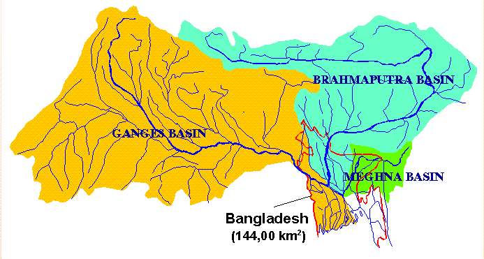
Bangladesh is a predominantly low lying country comprising the delta at the confluence of the Ganges, Brahmaputra and Meghna draining the Himalayan mountains through India and other neighbouring countries into the bay of Bengal
In Bangladesh, floods and flood management are a part of life. For centuries, people have been managing and controlling the passage of flood waters for protection and irrigation of crops. Minor floods are in fact beneficial, but major floods can be devastating to society, industry and the country’s economy. total flood protection is unrealistic and probably unwise. Nevertheless, schemes which reduce flood damage, ranging from flood preparedness to embankments, are necessary for the further development of Bangladesh.
Bangladesh is every year affected by floods and a reliable Flood Forecasting and Warnings System is vital for the country. In 1995 DHI was contracted to provide "Expansion of the Flood Forecasting and Warning Services in Bangladesh". It was immediately obvious that a complete GIS oriented system was required to handle the flood forecasting services. This includes :
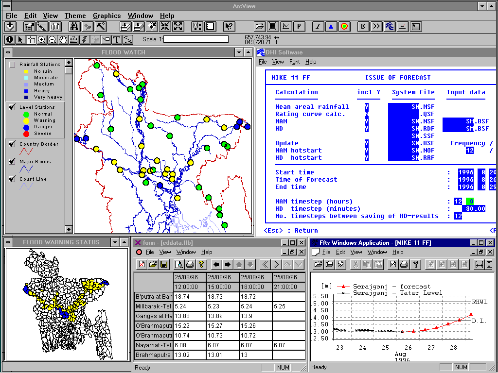
Each morning during the monsoon real time data (rainfall and water levels) are collected in the field from more than 70 stations and transmitted to the flood forecasting centre (FF&WC) in Dhaka. The telemetric data (digital) is directly incorporated into the Flood Watch real time data base. Some stations still rely on wireless (analogue) communication for transmitting the real time observations, this data is entered and processed via the data base management modules.
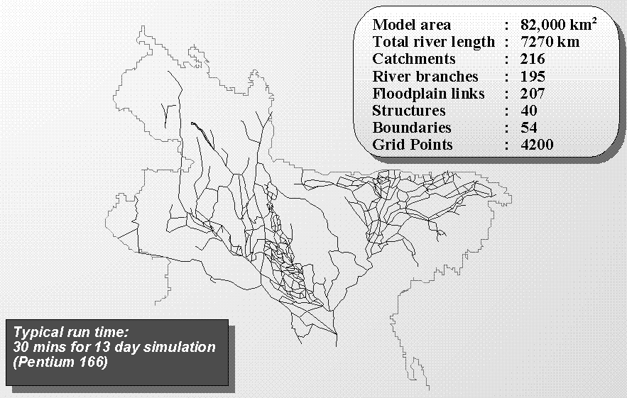
The new mathematical model covers in detail the entire northern part of the country. It is believed to be the largest one-dimensional flood forecast model presently in operation.
The MIKE 11 model developed and applied at the FF&WC comprises all major and secondary rivers in the Northern part of Bangladesh, with a total catchment area on 82,000 km2. The schematised river system in the model has a total length on 7270 km describing a very complex flow pattern.
The real time data information is used by the model via a special updating routine. The update function is applied to minimise the deviation between observed and simulated discharge/water level at the time of forecast. Based on the comprehensive model the flood forecasting system is used to predict river water levels and flood extents.
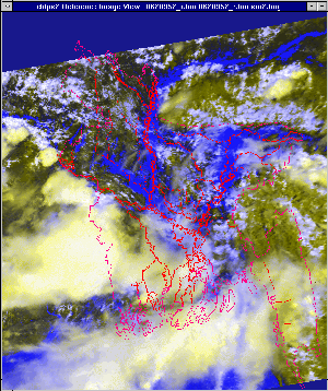
The model results are analysed and imported into the MIKE 11 GIS interface. Flood extents for selected areas are produced as flood inundation maps. This information is directly available in the Flood Watch system for further analysis and comparison with remote sensing data, such as satellite or SAR images. Comparison between simulated flood extents and flood extents delineated by satellite or SAR images helps to validate the model forecasts and also to improve model calibration. Application of SAR images, which can penetrate could cover, permitting accurate data acquisition for calibration and validation seems very promising.
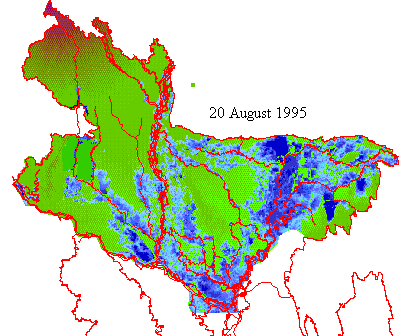
Comparison between simulated flood inundation maps and satellite images helps validate the model performance.
Acquisition of SAR imagery on a real time basis is presently not feasible but it will most likely be so in the future. When a real time link with a SAR producing unit is established flood images can be used to update flood plain flooding up to the time of forecast. This type of real time update has the potential to improve river and flood plain inundation forcasts significantly.
The project has also integrated a Flood Forecasting Warning and Response System (FFWRS) within the Flood Watch System.
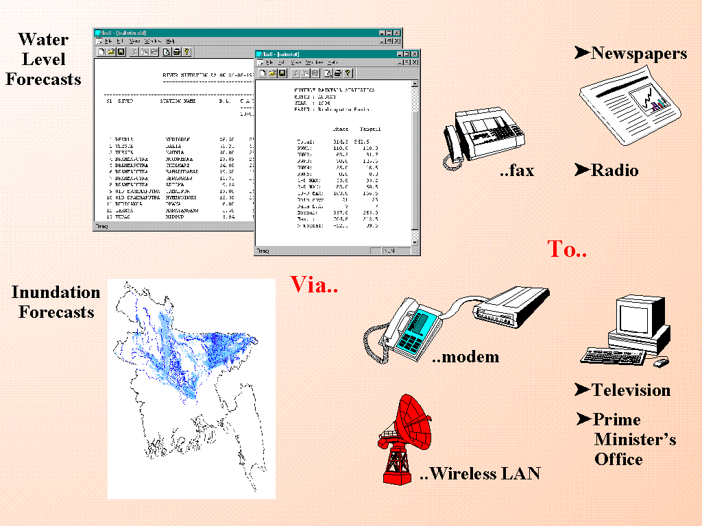
This FFWRS helps to increase the public awareness and enable the dissemination of flood warnings to the decision makers and the population.
The Flood Watch System is used to prepare bulletins, warning messages and graphical displays. Based on predicted flood extent a special flood-map is prepared for TV showing areas affected including a flood warning status.
CONCLUSION
The demand for means to control and predict floods has increased in many parts of the world in recent years, especially where major urban development has taken place in river flood plains.
The MIKE 11 "Flood Watch" is a Decision Support Framework for professionals involved in flood forecasting. The Flood Watch integrates an established one-dimensional hydrodynamic modelling system, MIKE 11. The MIKE 11 system includes extensive functionality for real-time flood forecasting integrated in an ArcView GIS environment composed as a single user friendly interface. The system has been extensively tested in several case studies, including Bangladesh, one of the world’s most complex hydraulic environments. The system has proven its capabilities in the fields of flood planning and structure design, as well as real time operation for flood forecasting. The user friendly interface makes it an ideal Decision Support tool to decision makers, as exemplified by its installation in the office of the Prime Minister of Bangladesh from where rapid responses to adverse flooding conditions can be initiated..
REFERENCES