A MOUSE GIS STUDY OF THE DRAINAGE IN DHAKA CITY
Ole Mark* Terry van Kalken** K. Rabbi** Jesper Kjelds*
* Danish Hydraulic Institute, Agern Allé 5, 2970 Hørsholm, Denmark.
**Surface Water Modelling Center, House 15A, Rd 35, Gulshan, Dhaka, Bangladesh
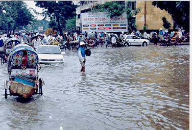
Figure 1. Example of flooding in Dhaka city during September 1996
KEYWORDS: ArcView, Digital Elevation Model, Flood control, Flood inundation maps, GIS, MOUSE, Urban drainage.
ABSTRACT
In Bangladesh, located on the extensive flood plains of the Ganges and Bramaputra Rivers flooding is a natural part of life. Thus water logging in the Dhaka Metropolitan is not a new problem. It's a part of life but the frequency of this problem is increasing. The city has been experiencing water logging for the last years even a little rain causes a serious problem for certain areas. Increased urban developments not providing sufficient drainage results in water logging leaving parts of Dhaka inundated for several days. This causes naturally large infrastructural problems for the city. Dhaka is protected from river flooding by an encircling embankment. Most of the time during the monsoon the water level in the river remains higher than the terrain inside the city area. This implies that the city drainage depends very much on the water levels of the peripheral river systems. Hence, standard draining by gravity may not always be possible. In order to facilitate and improve drainage it is considered to install drainage pumps at some of the FCD structures connecting to the rivers. Large reconstruction work has also been proposed.
In order to evaluate and optimise the various alleviation schemes a pilot hydrodynamic drainage model, has been made for a sub-catchment of the city. The MOUSE model has been selected for the modelling study. MOUSE computes water levels and flow both for the drainage pipes for the streets. In order to evaluate the results in terms of street flooding for the various alleviation schemes a Digital Elevation Model (DEM) has been established for the catchment area. The ArcView based MOUSE GIS system uses results from MOUSE (given as water depths in the streets) and the DEM to generate flood inundation maps. Flood maps visualises the spatial variation of the depth and extent of urban flooding scenarios for both historic as well as future scenarios
The integration and application of the MOUSE model with ArcView GIS provides a methodology for developing sustainable alleviation schemes. Such an integrated approach provide a very cost efficient system for planning and management of the drainage system of Dhaka City in the future. The developed technology can easily be transferred and applied to catchment areas experiencing similar problems.
INTRODUCTION
During the monsoon from May to October, the drainage of the Dhaka City is mostly dependent on the water levels of its peripheral river systems. During this period, river water levels generally remain higher than the internal drainage level. This major constraint to the effective surface drainage within the city area is aggravated by the wide range of rainfall intensities that prevail during the monsoon period. The situation worsens when monsoon runoff generated from short duration and high intensity rainfall coincide with high water level in the river systems. Flooding in the Dhaka Metropolitan area can be classified into two types. One results from high water levels of the peripheral river systems, thus rendering any natural drainage impossible. Another is caused by high intensity storm rainfall runoff in the city area which causes flooding also in situations where natural drainage might be possible.
River Flooding
River floods generally take place in the low-lying fringe areas outside the protective embankments once in every five to ten years. Dhaka City has experienced major flooding in 1954, 1955, 1970, 1974, 1980, 1987 and 1988. Among them, the 1988 flood was the largest ever recorded. Poor drainage capacities of the existing khals caused long flood duration in inland areas and aggravated the flood damage.
Rainfall Induced Flooding
Floods caused by local rainfall occur in the built-up areas of the city several times a year. These floods are mainly caused by inadequate existing drainage paths and their improper operation and maintenance. The severe water logging which occurred in September and October of 1996 was caused by blockages of the drainage system due to huge volumes of garbage and poly-bags. The areas of Shantinagar, Paltan and Matijheel which include many of the important business and Government offices of the country suffered most. Important street intersections were inundated for four days during 16-19 September 1996. The situation was severely aggravated because the Segunbagicha Khal, which conveys storm runoff from the areas to the receiving rivers, was not fully operational.
As a part of the drainage improvement plan of the Dhaka Metropolitan City, WHO DWASA is currently rehabilitating the natural channel section of the Segunbagicha Khal by replacing it with a concrete box culvert. After completion of 85% of the total works the construction has been stopped by court order due to land dispute with the owners. The total length of the box culvert is 2.1 km. Additionally, the following problems in the Dhaka drainage system have been identified by DWASA (Ref. 2):
Objectives and Scope of the Study
The objectives of the present study was to build a mathematical pilot model of a sub-catchment in Dhaka City and to test the applicability of the MOUSE modelling software for analysing the Dhaka City drainage. Hence, the model results of the present study should be interpreted as indicative only. To develop a mathematical model for any system, a clear and concise understanding of the different processes involved in the system is important. The sub-objectives and scope of the present study are:
Simulation of the existing condition in the Segunbagicha KHAL Catchment
System Description
Water from the Dhaka Metropolitan area is conveyed through drainage channels into the Turag River on the West, the Buriganga River on the South, the Balu River on the East, and Tongi Khal on the North. One of the major drainage channels in the city is the Segunbagicha Khal, which due to its relevance to the present modelling study is described in detail:
Segunbagicha Khal originates from the Ramna Park area and flows through the areas of Segunbagicha, Paltan, Matijheel and Gopibag. A distance of 3.4 km further downstream, it crosses Janapath and then meets with Gerani Khal before draining finally into the Balu River. Previously drainage from the Segunbagicha Khal used to depend on the water levels in both the Balu and the Buriganga rivers. As a part of the Dhaka Integrated Flood Protection Project a four-vent sluice gate has been constructed on the Segunbagicha Khal at the intersection with Janapath. The khal drains storm water from an upstream drainage catchment area of 4.54 km2. At present, an upgrade of the drainage system is taking place and a number of new sewer lines has been installed in the area.
Modelling Approach
Urban streets flooding may be due to numerous causes. Rainfall starts as overland flow on the street before entering the underground pipe system through catch pits. The duration of flooding on the street depends on its elevation and the intake capacity of the catch pits and underground pipes. If the intake capacity of the catch pits is limited, large volumes of runoff will be transported along the surface during high rain storms even though the underground sewer network may have sufficient capacity. In contrast, insufficient drainage capacity of the sewer pipes may also cause surface flooding even if the catch pit intake capacity is adequate.
The Dhaka City drainage system consists of the combination of closed conduits, box culvert and open channels. This complex system requires a model schematisation which allows a correct physical representation of the described interaction between the underground pipe and the street system. Surface flow on the streets should thus be described with more detailed methodology. The parallel system methodology adopted for the present modelling study is schematically outlined in Figure 2.
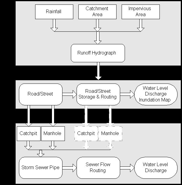
Figure 2. The methodology adopted for the present modelling study.
Hydraulic Modelling
The hydraulic module of MOUSE is applied to describe the following physical phenomena:
The nodes in the model describes the connection between and includes
thus both the networks of the underground pipe and the
hydraulic description of the street system. The description of the street
system can be divided into three parts:
A sketch of the connection between the streets and the pipe system can be seen in Figure 3.
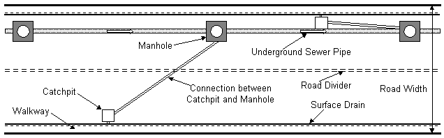
Figure 3. Sketch of the connection between the streets and the pipe system for the Dhaka drainage system.
Land Elevation Data
The land elevation data were essential to estimate the storage volume of the local streets. This data was unfortunately not available, hence the local storage volumes were based on very rough estimates. For future detailed analyses more accurate estimates of these storage volumes will be required. However, a survey was carried out to measure the ground elevations of the manholes. Usually, the ground invert of the manholes is flush with the road level. Hence, the surveyed data also applied to determine elevations along the roads.
All the streets aligned directly above the underground pipe system have
been included in the model. This parallel system approach is important
for the description of the flow exchange between the streets
and the pipe system. This implies that the layout plan of the street system
is the same as that of pipe system. In addition, the major streets which
convey flood waters have been identified and included in the model. Finally,
the box culvert which is nearing its full implementation, and the sluice
gate at the intersection of the khal with Janapath have been included in
the model description. The operation of the sluice gate depends on the
water level head across the sluice gate. The sluice gate is closed whenever
the water level in the Gerani Khal is higher than the water level inside
drainage area. The operational strategy of the gates and pumps is illustrated
in Figure 4.
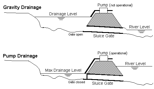
Figure 4. Illustration of the operational strategy of the gates and pumps.
GIS Data
The alignment off and elevations along the road network of the Segunbagicha Khal Catchment area were digitised by DMDP. Major roads in the model area were digitised by SWMC during the study from a map (1:20,000 scale).The map showing the drainage networks of the Dhaka City were collected from DWASA. The important features such as primary and secondary drains of the model area were digitised and used in the MOUSE model. A DEM grid of the study area were generated based on this available topographic data. The extent of the DEM is appox. 5x5 km. It is estimated that the DEM yields a sufficiently accurate representation of the elevations along the streets and other areas prone to flooding.
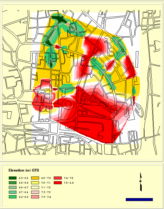
Figure 5. Digital elevation model of the Segunbagicha Khal Catchment.
Flood Inundation Maps
Flood Inundation maps provide a most effective media for visualising flooding. Results (here water levels) from a MOUSE simulation are available in the nodes and along the pipes connecting the nodes. Flood inundation maps for different scenarios, are generated using GIS. MOUSE results are geo-referenced and related through a coordinate system common with the DEM grid. These results can be displayed graphically in the GIS.
As explained earlier, two parallel and interconnected networks, one
for underground pipes and other for the street system,
have been modelled. The water levels on the streets mainly cause flooding
on the streets and the adjoining areas. Using interpolation routines in
MOUSE GIS continuous 3-D water surfaces were constructed based on the simulated
street water level. The DEM elevations were subsequently subtracted from
the water level surface delineating inundated areas by flood extent and
flood depth. To verify the flood maps interpolated from MOUSE simulations
these were compared with best available information on flooded areas The
possible extent of flooding for each of the street sections were estimated
based on the experience and judgement of the relevant engineers in the
DWASA and digitised. The comparison is shown on Figure 6.
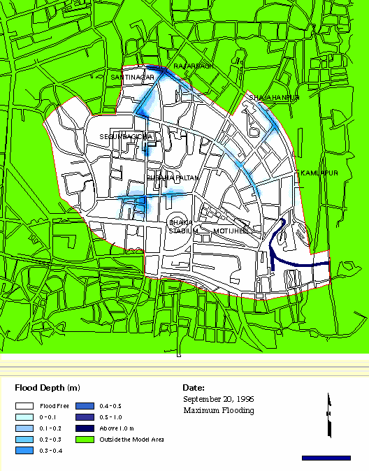
Figure 6. Comparison between simulated and observed flooded locations in the Segunbagicha Khal Catchment.
Simulation of September 1996 Water Logging
At present, the box culvert isn’t yet fully implemented due to land disputes between the Government and the public. It is estimated that it might take one to two years before it will be fully operational. During September 1996, some areas in the model area remained inundated for many days due to clogging of part of the drainage pipes and the box culvert. No exact knowledge exists about the clogging of the drainage pipes. Also, no information is available about the clogging of the completed part of the box culvert. The unfinished part of the box culvert where cross-sections were reduced has been identified. Due to this reduced capacity of certain sections of the drainage system parts of the model network were described with reduced flow area of the drainage pipes. The incomplete box culvert has been described with constricted section.
Historical rain data for September 1996 was used as input to MOUSE. There were four rainy days in the middle of September from the 16th to 19th. The table below shows hourly recorded data at the gauging station.
| Date | Rainfall, mm | Duration, hour | Remarks |
| 16 September, 1996 | 62 | 2 | 37 mm in the first hour |
| 17 September, 1996 | 29 | 2 | 28 mm in the first hour |
| 18 September, 1996 | 0.5 | 1 | - |
| 19 September, 1996 | 85 | 4 | 41.5 mm in the third hour |
Model simulations were carried out from 16th to 19th September 1996. A constant water level of 4.5 m in the river on the downstream side of the sluice gate was assumed, the level being based on a experience gained from previous study. The sluice gate was assumed to remain open when water level inside the drainage area was higher than the water level in the river. The initial water level inside the model area at the sluice gate was assumed to be 1.5 m.
SIMULATION OF ALLEVIATION SCHEMES
An effort was made to identify the possible alleviation measures for the present drainage problems of the Dhaka City. The pilot model was applied to test the performance of the model and to evaluate the impact on the drainage system for the following scenarios:
Below the effects of the alleviation schemes are described.
Use of Pumps at Selected Locations
As an ad-hoc measure it has been suggested to install pumps at a few selected critical locations. During the last water logging problems in the city, the DWASA arranged 19 pumps of 5 cusec capacity each at four locations to pump out the stagnant water from the city area. Besides, DCC also arranged 15 pumps of same capacity in different parts of the city. For the coming ‘97 monsoon DWASA has planned to use 40 pumps during the critical periods.
A model simulation was carried out for October 1996 rain storm event to evaluate the effect of using pumps on the flooding at Shantinagar crossing. Five pumps were assumed to be provided at the location. In reality there is no lake/pond available in the area where the pumped water can be stored. However, it has been assumed that storm water once pumped would not return back to the system. The results indicate that the impact of pumping is mostly local. Use of pumps at Shantinagar Crossing would reduce the duration of flooding from 24 hours to 7 hours at the Shantinagar Crossing. The maximum depth of flooding would not be affected. The result also illustrates that the flooding condition of the distant areas such as Kakrail Crossing, Middle-Radial Road Crossing and Fakirerpool Crossing would not be improved.
Excavation of the unfinished sections of the box culvert
Sections of the khal where the box culvert has not been build yet is proposed to be excavated as a measure to remove the back water effects from these locations and at the same time to facilitate the draining of the upstream areas. The section equivalent to the full depth of the box culvert as planned was considered for the MOUSE simulation. The drainage pipes were assumed to be blocked as of September and October 1996 condition. The simulation was carried out for the October 1996 rain storm. The result indicates that dredging of the unfinished locations of the box culvert would reduce the duration of flooding at Shantinagar Crossing from 24 hours to 18 hours and maximum depth of flooding from 75 cm to 65 cm. This means that unless the drainage pipes are cleaned properly no major improvement to the present water logging problem can be expected.
CONCLUSION
The present pilot study shows the applicability of the ArcView based MOUSE GIS system to reproduce and visualise the flooding scenarios of the past in Dhaka City. Further, the modelling system has been used to evaluate alternative alleviation schemes for reduction of the flooding problems in Dhaka City. However, the present efforts to finding a solution to the water logging problems in the Dhaka City should only be considered as the starting point, as more data would be required in order to make a more detailed study. The conclusion of the study is that using the hydrodynamic MOUSE model together with MOUSE GIS will provide a cost effective and informative methodology towards a finding an optimum solution of the recurrent water logging in Dhaka City.
As the modelling system applied in the study is a general modelling package, this system can be applied to similar urban flooding problems around the world.