
Philip Huijser, Alfred Dijkstra
The Netherlands ranks among the densely populated
areas in the world. Its fairways are extremely important from
an economic point of view. Rotterdam is the largest port in the
world. Every year many millions of tons of cargo are transported
from and to Germany via the river Rhine. In addition, river water
is used in the preparation of drinking water for a large part
of the population. The water is used by farmers to irrigate their
fields and as drinking water for cattle. Companies use it as cooling
water for machines and water managers use river water to keep
ditches and canals at the usual level. A calamity on the water
will affect many authorities in a relatively small area in a short
period of time. It is therefore extremely important that these
authorities are alerted quickly, so that measures can be taken
in time. That is why the Dutch Ministry of Transport, Public Works
and Water Management has developed the AQUABEL information system.
Illustration: The Rhine
River Basin
AQUABEL is an information system which supports the
Dutch government in dealing with incidents and calamities on national
waters. The system provides support in collecting and processing
the details of reports. For this purpose, a reporting system has
been developed which quickly collects all the relevant information.
After that, this data is passed on directly by the system via
various communication methods to relief agencies, authorities
and (drinking water) companies. AQUABEL also contains the details
of chemicals, which provide crisis managers with a quick insight
into the seriousness of the pollution and the measures to be taken.
AQUABEL has a GIS (MapObjects) interface which shows
the service area for which the relevant local authorities are
responsible. The GIS interface contains many functionalities.
Apart from the usual methods of searching and retrieving local
data, AQUABEL is also able to communicate through GIS. Based on
the details of the location, it is decided which relief agencies
are to be alerted. After an object on the GIS map is selected,
the telephone number of the person to be contacted shows up with
whom the operator can make direct contact by telephone. In addition
to the telephone, other means of communication can also be used
with AQUABEL (fax, e-mail), which are controlled from the GIS
interface. Based on the report and location data, it is possible
to alert many organisations in a very short period of time.
The AQUABEL system is linked to other information
systems which play an important part in integrated water management
in the Netherlands. Some examples are: the IVS'90 system (a system
that records the details of vessels and cargoes and makes these
travel with the vessel from the place of loading to the place
of unloading) and the Surface Waters Contamination Act info system
(a system that records the details of companies discharging waste
water into the surface water).
In the eighties, the river Rhine was seriously polluted
due to calamities. Every year, many tons of chemicals were discharged
through industrial operations and accidents.

Illustration: International
reports of calamities on the Rhine
In 1986, a fire at the Sandoz company in Basle polluted the Rhine
with pesticides. The results were felt all along the river Rhine:
the biological life in a large part of the Rhine was disrupted,
thousands of fish died and the production of drinking water had
to be ceased.
From the evaluation it became evident that the handling
(recording and communication) could be improved considerably.
Apart from that, it became clear that the national and international
authorities in many cases did not have any emergency plans to
ensure that proper action was taken.
In the International Rhine Commission, all countries riparian
to the Rhine agreed to reduce the pollution of the Rhine substantially.
For example, it became compulsory for companies to build basins
to collect incidental pollution and to install water treatment
plants. A campaign was set up to reintroduce salmon into the Rhine
before the year 2000. In the Netherlands, a national plan has
been drawn up to improve the water quality of the rivers and programmes
have been developed to reduce the number of accidents causing
pollution.
In 1988, the Dutch Department of Public Works took the initiative to develop an automated system called 'AQUABEL' which would make it possible to improve the handling of calamities substantially. In 1994, the system was put into use by the Department of Public Works. In 1997, it has been improved considerably and a geographical interface has been added. The system is installed at the Vessel Traffic Service stations of the Department of Public Works.
Originally, AQUABEL was developed to improve the
handling of very serious calamities. Recently, however, it has
also been used increasingly to report on cases of small-scale
contamination. In 1996, about 2000 cases of contamination were
reported.
The manufacturing industry
In the Netherlands, surface water is often used by companies for cooling and processing purposes. The power companies, for example, use enormous quantities of water to cool their turbines. This water is often, immediately afterwards, discharged back into the surface water. Some companies treat the water first, after which they use it for processing. During the production process, waste flows are released which companies are not allowed to discharge. As a consequence, the waste water is treated before it can be discharged into the surface water.
There is a risk at these companies that due to breakdowns
or accidents hazardous substances are discharged through the cooling
or process water. In those cases it is of vital importance that
the authorities are alerted quickly. They will alert companies,
water managers, farmers using the water for sprinkling fields
or using it as drinking water for cattle, people using the water
for recreation, or drinking water companies, so that they can
take measures to limit the damage as much as possible.
Drinking water
In the Rhine basin, approx. 90 million people are
dependent on drinking water coming from the river Rhine. A number
of water companies in the Netherlands use the surface water to
prepare the drinking water. A large part of the Dutch population
is dependent on this water. Along the Rhine and Meuse rivers and
the IJsselmeer lake there are large inlets where the river water
is pumped up to be processed into water for drinking and processing
purposes. If the surface water is seriously polluted it is extremely
important that the information is made available to the water
companies quickly. They can then take measures, such as interrupting
the collection of river water until the pollution has passed.
The shipping trade
To a country such as the Netherlands, with its favourable position on the estuaries of the rivers Rhine, Scheldt and Meuse, water has always been an important transport artery.
Rotterdam is the most important transit port for the European hinterland. Duisburg (Germany) is the largest port on the Rhine. A lot of goods are transported in bulk, such as:
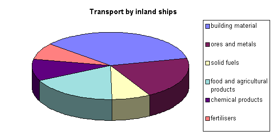
Illustration: Types of
goods per inland ship
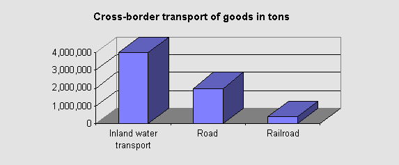
Annually, more than 400 million tons (that is 400
thousand million kilos!) are transported by water. More than 60%
of the total international transport of goods is by ship!
A lot of transport also means a higher risk of accidents. From a relative point of view, a ship is a safe means of transport, but in case of an accident the consequences for the environment are often disastrous.
A tanker that collides may be ripped open and lose
part of its cargo, and freighters may lose containers that get
swept overboard.
Integrated water management
and AQUABEL
Integrated water management is the management of water systems in which an effort is made to bring the various functions of the water system into line.
The functions of the water system are:
As the manager of most of the large rivers and canals,
the Department of Public Works is responsible for proper integrated
management. To reduce the impact of possible calamities on the
water system to the minimum, the Department of Public Works has
designed its organisation and information systems to enable it
to respond to incidents adequately.
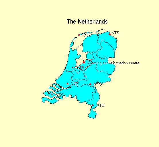
There are various regional reporting stations along
the most important fairways in the Netherlands, the so-called
Vessel Traffic Service (VTS) stations. These stations are the
eyes and ears of the Department of Public Works. This is where
all reports are received.
The VTS make use of information systems which are of vital importance
to the handling of incidents, e.g. IVS'90 and AQUABEL.
IVS'90 is an information system in which all important data of
the shipping trade is entered, such as what type of cargo and
how much is being transported, so that in the event of a collision
it is immediately clear which kind of help is required. This data
is transferred to AQUABEL.
In addition, there is a national Inland Waters Information
Centre of the Institute for Inland Water Management and Waste
Water Treatment (RIZA). This centre operates as the advice and
information centre in the event of great calamities. Disaster
experts are available here.
The Information Centre does not only use AQUABEL, but also certain
models which predict the duration and concentration of a contamination.
AQUABEL has a GIS (MapObjects) Interface which shows the service area for which the relevant local authorities are responsible. The GIS interface contains many functionalities. Apart from the usual methods of searching and retrieving local details, AQUABEL is also able to communicate through GIS. Based on the details of the location, it is decided which relief agencies are to be alerted.
After an object on the GIS map is selected, the telephone number of the person to be contacted shows up with whom the operator can make direct contact by telephone. In addition to communicating by telephone, AQUABEL is also able to send faxes and E-mail from the GIS interface.
Thanks to the reporting and location data, it is possible to alert the right authorities in a very short period of time.
Based on this data the following measures can be
taken, e.g.: Evacuation of casualties, discontinuation the pollution,
extinguishing fires, control of released substances, research
into the consequences of the contamination, calculation of the
spread with the aid of duration and spread models, obstruction
of navigation, tracing offenders, etc.
The new AQUABEL system now consists of three modules:
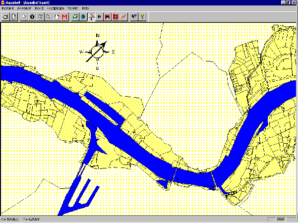
Illustration: AQUABEL
GIS interface
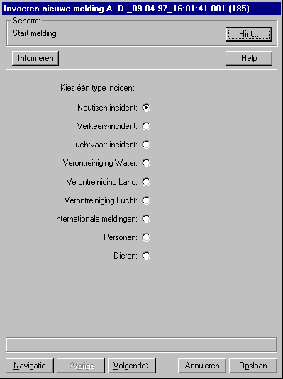
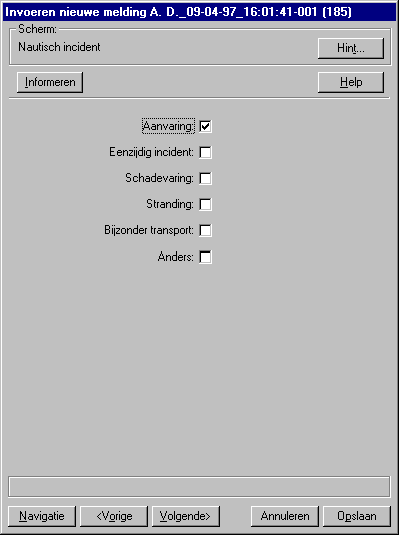
Illustration: Reports
module
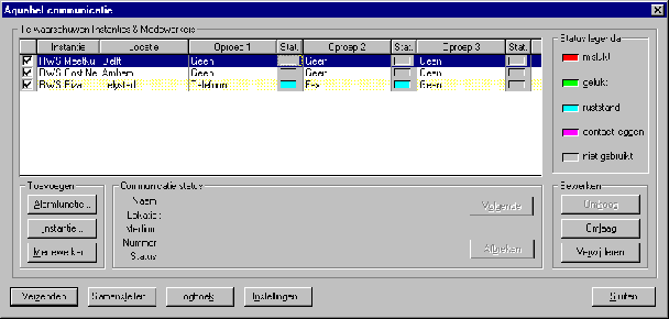
Illustration: Communication
module
The AQUABEL system is linked to other information
system which play an important part in integrated water management
in the Netherlands. Some examples are: the IVS'90 system (which
records the data on vessels and cargoes and makes these travel
with the vessel from the place of loading to the place of unloading)
and the Surface Waters Contamination Act info system (recording
the details of companies discharging waste water into the surface
water).
What can we do with AQUABEL's GIS interface?
Quick insight into environmentally vulnerable areas is obtained by switching to another overlay file. It is also possible to obtain information from the land register and on companies situated on the water.
Below you will find an example of object selection:
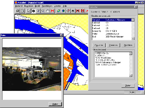
Illustration: an object
selection
Functional Design and Realisation
AQUABEL has been developed by all the regional Departments of Public Works in the Netherlands. It is therefore important that all these departments contribute to the decision which functionalities should be included in the AQUABEL system.
The functional specifications have been defined in three sub-projects:
The realisation was awarded to EDS Netherlands. In about 4 months' time the new system was developed. It was the first time that MapObjects release 1.0 was used for this.
MapObjects has more advantages than ArcView for the development of AQUABEL, such as:
By means of RAD technology (Rapid Applications Development), the interfaces of the system were defined during workshops.
The reporting system consists of a Microsoft Access database, in which the application manager is able to enter or delete questions himself. A generator built in Visual C++ ensures that the questions from the database show up and that the answers can be saved.
The GEO interface has also been developed in this
way. This has determined the AQUABEL user interface to a considerable
extent.
The Technical Infrastructure was determined largely
by the requirement that AQUABEL must be able to run stand-alone
with the aid of W95 or WNT 4.0.
The communication of AQUABEL moreover requires that
a fast fax-modem is connected to the system, preferably with various
telephone lines. The options for communication are e.g.: fax,
e-mail, buzzer, maxer, radiophone and (car-) telephone.
Links
AQUABEL has links with the following systems:
Authors:
Ing. Ph.J. Huijser
A. Dijkstra, B.Ec.
Rijkswaterstaat RIZA
Postbus 17
8200 AA Lelystad
Netherlands
Telephone: 00 31 320298411
Fax: 00 31 320249218
E-mail: