
Professor Duane F. Marble
Department of Geography
The Ohio State University
Columbus, OH 43210
marble.1@osu.edu
Mr. Victor Mora
Office of Enrollment Management
The Ohio State University
Columbus, OH 43210
mora.1@osu.edu
Mr. Manuel Granados
Department of Geography
The Ohio State University
Columbus, OH 43210
mgranado@geography.ohio-state.edu
A major strategic planning issue for college and university admissions
is the development of inquiries that will, when turned into admitted students,
fulfill stated institutional goals with respect to quality, quantity and
diversity. This is a difficult task in light of the significant problem
involved in identifying potential prospects among a very large population
and of the increasing competition for students between institutions.
The approach developed at The Ohio State University links current, detailed
demographic data at the block group level with local information on enrollees
to identify geodemographic profiles of those potential students most likely
to enroll and graduate from the institution. This information is then used
to support recruitment activities directed toward specific areas and specific
individual inquiries. Our work represents an unusual collaboration between
an academic department and an administrative unit of the university.
The methodology used was developed by Herries and Marble and is reviewed
in another paper at these meetings. The present paper supplements the Herries
and Marble paper by providing some concrete demonstrations of the application
of this methodology within the context of current recruiting activities
by The Ohio State University.
In the 1990's U.S. colleges and universities are spending more money
on student recruitment and are using more sophisticated marketing approaches
than in the past. In part this is because colleges and universities are
targeting special populations such as: full pay, high academic ability,
talented/gifted, international, adult and parttime learners, long
distance learners, etc. Another major factor is the growing competition
between institutions for a share of the student population. As a result,
there is more reliance being placed on the use of technology to develop
targeting strategies directed toward special populations.
Bombarded with college catalogues, brochures, letters of invitation,
scholarship offerings, prospective students and their parents often have
a difficult time making the right choice. Parents feel that they are in
a buyers market and actively seek out the "best deals," particularly
if their children have good academic credentials. In quest of visibility
in this highly competitive market colleges and universities each year spend
more than $100 million on student search and contact. In the late 1980's,
the average high school student was contacted by about 20 colleges; now,
depending on the academic credentials of the student and the test score
criterion of the institution, a student may be contacted by as many as
50 to 100 different institutions. This level of activity reflects substantial
increases in the amount of money institutions spend to recruit a freshman.
For example, the typical private college went from an expenditure of $470
in the late 1980's to $1,560 in the mid1990's to recruit a freshman
while the average public institution currently spends about $400 (Sevier
and Smith, 1994).
Faced with these external pressures, colleges and universities are struggling
to cope with change and with a multitude of environment factors that they
can not control. The challenge for many institutions is the need to allocate
greater and greater resources to achieve only marginal improvements in
their recruitment at a time when, in the public sector, state legislatures
are faced with hard decisions relating to the distribution of limited resources
to competing priorities such as education, welfare, and prisons. These
competing areas for state funding are putting great pressure on public
colleges and universities throughout the U.S. Public colleges and universities
are now "... confronting a truth learned by any student who has ever
had a pizza delivered: It's not the size of the pie that matters, but how
many people want a slice." (The Chronicle of Higher Education,
January 10, 1997)
In response to these problems, some universities have created offices
of enrollment management in order to more closely integrate key functions
such as admissions, financial aid and retention. Enrollment management
staff are challenged to not only generate a desired profile of new students
but also to keep them to graduation. Not an easy challenge, particularly
when it must be done with limited resources! The combination of enrollment
management and new technology has proved to be especially advantageous
in the case of The Ohio State University.
In just few years, the Office of Enrollment Management at The Ohio State
University has made tremendous progress in the use of technology to improve
its recruitment of new freshman students. Activities have shifted from
simply publishing and mailing brochures and school catalogues to prospective
students to a well coordinated approach which includes personalization
and the use of database management technologies and other forms of computer
based technologies. One of the most important of these is geographic information
systems (GIS) technology.
The Office of Enrollment Management, in close cooperation with the Department
of Geography, began to make use of GIS technology approximately three years
ago and has been in the process of integrating this technology into its
operations at both the strategic and tactical levels. The following is
a brief summary of some of the progress made in the incorporation of GIS
technology in our office:
1) The possible use of GIS technology in the recruitment process for new first quarter freshmen (NFQF) formed the basis for a project in Professor Marble's Spring 1994 graduate course on Design and Implementation of Geographic Information Systems (see: http://www.geography.ohio-state.edu/ for further information on the structure of this course). An extensive report was prepared.
2) A Graduate Research Associate (Mr. Jim Herries) from the Dept. of
Geography was hired to begin building the infrastructure and to create
initial test products. Data utilized included freshman admissions historical
data, First Street (1990 Census), and the special school district tabulation
of the 1990 Census; data handling was by ArcView. A M.A. thesis was subsequently
produced (Herries, 1995).
3) Conducted several spatial analyses of the Ohio component of the freshman class throughout different stages of the recruitment process (at the Block Group level). Special bivariate maps were created to show both market potential and penetration at the school district level .
4) In order to obtain access to more current small area data, we entered
into a license agreement with Claritas to provide us with their Census
updates, PRIZM clusters/lifestyle segmentation and TIGER files. A preliminary
PRIZM cluster analysis of Autumn 1995 NFQF [new fall quarter freshmen]
was undertaken that identified preliminary Hot Spots at the block
group level (for Ohio only). These initial hot spots were based only upon
demonstrated propensity to enroll at Ohio State.
5) Created a comprehensive Ohio database at the block group and school
district levels containing Census, Claritas Census update and PRIZM cluster
analysis information as well as a variety of local admissionrelated
variables.
6) Expanded the PRIZM profile analysis to cover three years of recent
graduates. This analysis provided information in line with the notion that
the mission of the university is to graduate students and not just to get
them on campus.
7) Conducted an additional PRIZM cluster analysis of Autumn 1995 and Autumn 1996 NFQF and redefined Hot, Warm, and Cold spots for the State of Ohio by using a weighted score approach based upon (a) propensity to enroll, (b) efficiency in drawing students from the base population in prior years, and (c) propensity to graduate from OSU. (See below.)
8) Used a PRIZM cluster analysis of inquiries for the 1997 freshman
class to assist the Freshman Admissions area with personalization throughout
the recruitment process. Some examples: telecounseling, personalized correspondence,
faculty contact, campus visits, etc.
9) Developed income/wealth grids to assist the Financial Aid area in
developing special followup strategies for nonOhio students who
have experienced financial difficulties after arriving at the university
(see below).
In addition to the effectiveness of the GISbased operations, we
also feel that these activities form an viable model for the development
of cooperative activities between academic departments and administrative
units of the university. The pattern in many universities has been to ignore
the local talent pool represented by the faculty and graduate students
in favor of external consultants who have often supplied only generic solutions
or solutions that could be restructured only by the consultant. The local
development of expertise in GIS applications and spatial analysis permits
far greater longrun flexibility on the part of the institution and
at generally lower cost.
To evaluate the potential utility of GIS technology, as well as other
tools, we found it necessary to develop a good conceptual view of the way
that the college and university admissions process is carried out. The
conceptual model developed by Marble and Herries (1996) represents the
results of our approach, based upon significant interaction with college
admissions staff, to the needed structure. While some details may vary
from institution to institution, we feel that the basic structure is applicable
to many U.S.based situations.
The conceptual model focuses upon two major activities related to current
college and university admission operations:
Identification of those prospects who are most likely to become enrollees
or graduates of the institution.
How can the admissions office winnow these potential contacts down to
a set that appear to be both desirable from the institution's standpoint
and that also can be dealt with within the limited recruiting resources
available?
Improving the performance of the admission process once specific
individuals have been identified through their submission of an inquiry
or application.
How can we identify from those persons inquiring about the institution
those who are most likely to subsequently submit applications? Given the
applicant pool, who are those most likely to enroll after having been admitted
to our institution?
The conceptual model is discussed in some detail in papers by Marble and Herries (1996) and Herries and Marble (1997), but Figure 1 (taken from those papers) provides an overall summary. Basically, small area data (at the Census block group level) is processed through a demographic filter that identifies subgroups within the overall population that, on the basis of recent enrollment management experience, are most likely to enroll at or graduate from the institution. Data on the relative location of these subgroups are then passed through special geographic filters (Harries, 1995) to locationally bias the demographic outputs. The resulting definition of hot spots represents an example of the way that GIS technology can be used to assist in admissions activities at the strategic planning level since these hot spots represent suggested targets for most effective recruitment activities.
Figure 1 A Conceptual Model of the Admissions Process
Once individuals have been explicitly identified, more traditional tactical
admissions activities (screening for admission and financial aid, etc.)
come to the fore. However the size of the applicant and admissions pools,
together with limited admissions resources, often requires that additional
screening take place. Of the admitted students, which ones should be the
focus of the staff's attention? Some criteria immediately suggest themselves
such as superior ACT/SAT scores, individuals representing specific geographic
or ethnic groups, etc. However even these subcategories may prove
to be larger than can be effectively handled with existing resources. Reapplying
the demographic and geographic filters can then assist in the tactical
identification of, say, individuals with high test scores whose geodemographic
context appears most favorable for ultimate enrollment.
The following two examples illustrate how GIS technology can be utilized
to assist in college and university enrollment management. Both are drawn
from ongoing analytical work at the Office of Enrollment Management of
The Ohio State University.
One of the most pressing nontraditional admissions problems is
the need to generate inquiries that can subsequently be turned into applicants
and, ultimately, enrolled students. Instead of dealing only with the passive
processing of a substantial stream of inquiries and applications, the university
admissions office is now faced with the difficult problem of generating
the inquiry stream in the first place. There are currently nearly half
a million individuals in the 1417 year old age group within the state
of Ohio; many of these are not collegebound and others who are may
not be a good fit with what a particular Ohio institution of higher education
has to offer.
Resources are limited and today the institution most likely has specific
(and sometimes rapidly changing) recruitment goals in terms of quality,
quantity and diversity. How can we identify those subgroups within this
population that will most likely match these goals and will also be inclined
toward enrollment at a specific institution? Traditional approaches such
as purchasing the names and addresses of all secondary school students
who take standardized entrance examinations (ACT or SAT) and score above
some set quality level are of some help. However this may give us only
an order of magnitude reduction in the size of the problem that is faced
and the resulting subgroup may still be too large to be effectively handled.
This is where the effective use of geodemographics and GIS technology can
be of significant assistance.
As part of the geodemographic data set obtained from Claritas (similar
databases are available from other commercial sources such as Equifax),
each Census block group is characterized as belonging to one of 62 population
subgroups or clusters. These population clusters are established by applying
multivariate clustering to a wide range of variables including updated
Census variables, information from credit card databases, etc. Claritas
notes that this "defines every micro-neighborhood in the United States
in terms of 62 demographically and behaviorally distinct types." The
block group is the smallest statistical area for which much of the U.S.
socioeconomic data is reported and this areal unit usually contains
a small enough number of households to permit a reasonable working assumption
of areal homogeneity.
We can identify a group of existing students, for example all the new freshman enrollees in the Fall term of the 199697 academic year, and by geocoding their home addresses associate each of them with one of the 62 population clusters. A profile of the entering freshman class can then be established by simply creating a frequency distribution over the 62 clusters. Figure 2 shows two such profiles. The shaded profile shows the 62 clusters sorted from largest to smallest with respect to their contribution to one institution, while the vertical bars show the contribution of each of the clusters to the freshman population at another institution. The differences between the two institutions are quite striking. Table 1 provides some representative information on several of the clusters. It is easy to see that some of the clusters may appear more attractive than others. For example, cluster 9 contains a substantial number of individuals in the 1417 age group as well as enjoying good enrollment and graduation rates.
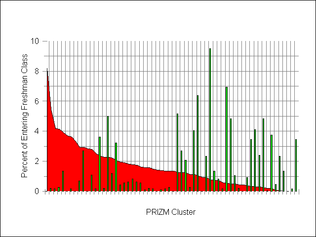
Figure 2 PRIZM Cluster Profiles of Two Academic Institutions
Operationally, it would be dangerous to assume that the profile for
any one year would continue to be representative of the composition another
year's incoming freshman class. However examination of student profiles
generated over several years show that a substantial amount of stability
is present. While some changes occur from year to year in individual clusters,
the overall profile remains much the same.
Profiles can easily be generated for other groups that may be of interest.
In one such case we identified a group of students who had entered OSU
as freshman and who had subsequently graduated from the institution. Their
profile (based upon a pool of three years of graduates) did display some
interesting differences when compared to the profile of the entering freshman
class. Some of the clusters showed a substantially higher or lower propensity
to reach graduation than others. This introduces another interesting variation
into the recruitment process: it is not more reasonable to target those
potential students who are more likely to graduate than just those who
are likely to enroll? Or given both pieces of information, how should they
be combined?
Given current estimates of the 1417 year old population in each of the Ohio block groups (there are just over 10,000 of these), we can easily create estimates of recruiting yields at the inquiry, admission and enrollment stages. (See Figure 3) We can identify those block groups containing a substantial number of potential students and where we have done well from a recruiting standpoint. We can also identify those areas containing only a small number of individuals in the relevant age group and where it would not appear to be efficient to direct substantial recruiting resources.
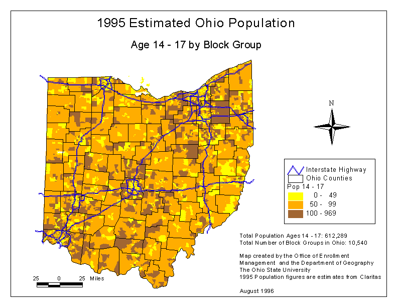
Figure 3 Block Group Distribution of 14-17 Year Olds in Ohio
Given these three views, we can then decide if we wish to make use of any one of them or to utilize all three of them in some weighted combination. One example of the outcome of using such a weighted view may be seen in Figure 4 where hot, warm and cool spots are defined for each of the block groups in the State of Ohio. The hot spots represent a group of clusters that, according to the weighted scale used, are of highest interest. The cool spots represent the other extreme while the warm spots cover the remainder of the block groups.
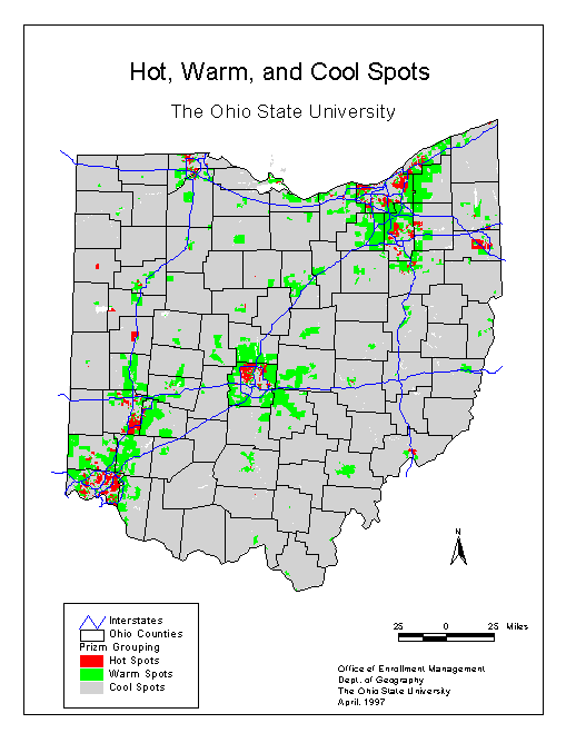
Figure 4 OSU Hot/Warm/Cool Spots in the State of Ohio
The hot spot definitions may be utilized in a number of different ways.
We may make use of them to establish priorities for direct mail and telecounseling
activities or they may be aggregated to the school district level to assist
in establishing high school visit priorities, etc. We may also utilize
them to establish contact priorities within lists of individuals (e.g.,
those with high ACT scores) that have been acquired from outside sources.
We are just beginning to examine the application of GIS technology and
geodemographics to problems in the financial aid area. However one interesting
test case was recently run. Admissions counselors have been reporting a
number of cases of outofstate freshmen students who were dropping
out before the end of their first year due to financial problems. In many
cases these students were selffinanced and came from households whose
income levels where at the high end of the scale. They appeared to have
underestimated the cost of going outofstate for their schooling.
The problem of generating the additional financial resources appears to
be related to the difference between household income and household wealth.
[Household wealth may be defined as the sum of all financial assets minus
the sum of all financial liabilities.] When confronted with the need for
expenditures in excess of those estimated, high income/low wealth households
may lack the resources to fill the gap. All current income may be allocated
and their level of other financial liabilities (home and car loans, etc.)
may be too high to permit additional ones to be added.
Although the number of students falling into this category is not high, the university felt that it might be possible to extend a helping hand by providing potential students who may fall into the high income/low wealth category with additional information on the costs of attending OSU so that more effective budgeting could be accomplished by the household. We have attempted to identify these households by examining block group deviations from median income and wealth levels for each state of interest (12 in all). An income/wealth matrix was built based upon deviations from the median values (e.g., median to plus onehalf SD, median to minus onehalf SD, etc.). Figure 5 provides a visualization of the income/wealth matrix for the state of New York. The two median values fall in the middle of the matrix with low income/low wealth areas occurring in the lower left hand corner of the display.
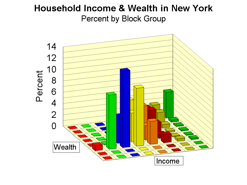
Figure 5 Block Group Income and Wealth Matrix for the State of New York
The block groups of interest are those to be found in the cells lying
at the right hand end of the income axis (high incomes) and close to that
axis (low wealth). Applicants coming from household in any of the block
groups in this portion of the matrix represent potential targets for the
additional cost/budgeting information. The investigation of applications
of geodemographics and GIS technology to other areas related to financial
aid is continuing.
This paper has outlined some of the activities at The Ohio State University
with respect to the application of geodemographics and GIS technology to
enrollment management questions. A substantial number of additional questions
remain to be addressed. These include studies of the structural composition
of the transfer student population (both those leaving and those coming
in), more detailed comparisons of the student profiles for instate
vs outofstate students, structural comparisons of the profiles
for students in different colleges of the university, etc. In addition,
from a methodological standpoint, we are working to refine our geographic
filters and to develop an ArcViewbased application that will make
the technology more accessible to Enrollment Management professional staff.
Some useful lessons have been learned:
Eason, Ken, 1988. Information Technology and Organizational Change.
London: Taylor & Francis.
Herries, James P., 1995. 'The LandGrant Public University in a
Competitive Market: An Evaluation of Freshman Enrollment Attraction of
The Ohio State University,' unpublished M. A. thesis, Department of Geography,
The Ohio State University.
________ and Duane F. Marble, 1997. 'A Model for the Use of GIS Technology
in College and University Admissions Planning,' paper prepared for presentation
at the 1997 Esri User Conference.
Marble, Duane F., et al, 1994. 'A Geographic Information System for
the OSU Office of Admissions and Financial Aid,' unpublished report, Geographic
Information Systems Laboratory, OSU Department of Geography
________, Victor J. Mora, and James P. Herries, 1995. 'Applying GIS
Technology to the Freshman Admissions Process at a Large University,' Proceedings,
1995 Esri User Conference. Esri: Redlands, CA. Note: this paper is available
as an HTML document from http://www.geography.ohio-state.edu and
from http://www.Esri.com.
________ and James P. Herries, 1996. 'Geodemographic Analysis and GIS
Technology in College and University Admissions Planning,' in the Proceedings
of the Sixth International Conference on Applied and Business Demography,
September 1996.
Sevier, Robert A. and Robert M. Smith, 1994. "Developing a Strategic
Marketing Plan," seminar presentation by Stamats Communications.