Due to the great demand for increased efficiency among the public transit systems, LYNX, the Central Florida Transit Authority, selected Post, Buckley, Schuh and Jernigan to assist them in the development and implementation of a GIS-based management system for their bus system. The initial project involved three phases: initial spatial database development, development of a customer service information system, and integration of non-spatial databases.
The initial spatial database development included the compilation of a digitally geocoded street network for all counties serviced by the LYNX system. The formation of this database layer involved bringing together data from various sources and formats, since the counties serviced by LYNX operate on different software systems. Reference database layers, including zip code maps and municipal boundaries, were also compiled in support of the addressed street maps. The LYNX bus routes were entered into GIS and PBS&J worked with the LYNX team to determine the unique naming conventions identifying the routes and additional data which needed to be related to this particular spatial reference. Finally, various sources of land use information were reviewed for their accuracy and compatibility with the LYNX system in order to determine the background layer that would best suit their needs.
The customer information system involved the addition of bus stop, link, transfer, schools, shelters, and park and ride locations, as well as locations of major points of interest in the Orlando area. The intention of LYNX is to access the GIS database through the ArcView software at the desktops of the customer service representatives. PBS&J developed a Map Objects application to facilitate queries which are performed frequently in response to the public. PBS&J will be providing full software and data usage training to LYNX staff and work alongside the customer service representatives throughout the BETA testing in order to refine the database for efficient use.
Finally, PBS&J will work with other LYNX consultants who are responsible for the preparation of transit-related non spatial databases and will determine appropriate methodology for integration of this data with the initially developed spatial data sets. PBS&J will assist the outside consultants by providing direction regarding the spatial database structure and the implemented naming conventions.
The need for public transportation in the Orlando area has grown due to an influx of people to the Central Florida region, increased tourism and an outdated highway infrastructure. In the last five years, over 200,000 new residents have moved into Orlando and the surrounding Central Florida communities. Commuting times have steadily grown longer as more and more people travel Interstate 4, the main artery between the east and west coasts of Florida, and drive the already crowded tertiary roads.
As the only transit system serving Orange, Osceola and Seminole counties, the LYNX service area encompasses over 2550 square miles and runs 200 buses during peak times. During the last six years ridership has more than doubled, growing from over seven million in FY 1990 to over 15.6 million in FY 1996. In order to sufficiently serve their customers, LYNX personnel must have an extensive knowledge of not only the street networks of these areas but also data such as routes, time schedules, shelter locations and transfer information. Until recently, most of this data was not in digital format. Customer service representatives had the cumbersome task of finding data by looking through volumes of paper schedules, maps and manuals.
Exhibit 1. A LYNX bus in downtown Orlando
The original application idea proposed to LYNX by PBS&J focused on modifying existing services in order to increase ridership and expand the current routing system. Data would be collected to produce a ridership profile. This profile could then be applied to local population databases to locate areas in need of transportation services.
However, LYNX had an idea of their own. They proposed that a Customer Service Center Application be developed which would allow them to focus on improving the quality of service to existing customers instead of only trying to attract new clients. An increase in the efficiency of service center personnel was also a priority. Customer service representatives must dig through an enormous amount of data in order to answer questions posed to them by their riders. Those questions could be answered in a matter of seconds through a custom graphical interface linked to a digital database.
Another problem the LYNX application could solve is the amount of lag time between actual routing/scheduling changes and the time it takes to pass that information along to the customers. Expansion and maintenance of the LYNX database takes place on a quarterly basis. It currently takes weeks to create a new route map and update the schedules that correspond to it. A hard copy output of this information could be generated quickly and efficiently using GIS software.
The initial phase of the project was to compile a digitally geocoded street network for the three counties serviced by the LYNX system. Orange County is the hub of the service area, bordered on the north by Seminole County and on the south by Osceola County. Building this layer involved bringing together data from three different data sources in three different formats, created by three different GIS systems. Orange County, using Vision software, delivered their street centerline file in .DXF format. There were 36 .DXF files to be converted into ArcInfo coverages and then joined together to create a seamless database. Seminole County, working with ArcInfo, delivered a complete, geocodable file that contained the most up to date information available. Osceola County, whose GIS software consists of Genemap, currently has no data of their own for street centerlines, therefore, TIGER 94 data was used for this area.
There were three problems encountered during this phase of development. First, because all of the counties used different sources for their data, the three counties did not match up well along their borders. This was not considered critical at this stage since the current scope of the project did not call for any type of routing to occur. Secondly, it was decided early on in the project that the streets within a half mile of the bus stops were critical because data showed that most of the questions from riders came from within that area. Therefore it was important that these streets be well geocoded. The use of TIGER 94 data made geocoding difficult because the address ranges for many of the streets did not exist and hours were spent manually entering address ranges and street names to increase the probability of a match while using the application. Finally, in order for the program to run as smoothly as possible, all of the geocoding items for each of the three files had to be standardized. For example, the item name for streets in Seminole County was "street.name", while in Orange County it was called "streets", and finally, in Osceola County it was labeled "fname". Item names for the prefix direction, street name, street type and suffix direction were decided upon and incorporated into each file.
LYNX currently offers 54 regular routes that travel throughout the three county area. For the purpose of our application, each route was individually extracted from the three street centerline files and saved into their own coverages. An item was added to identify each route by its corresponding number, or in some instances, its name.
The second phase of the project focused on the development of a customer service information system. At this point, databases from LYNX and those created by PBS&J came together to provide the non-spatial data that would eventually be utilized by customer service representatives through a graphical interface.
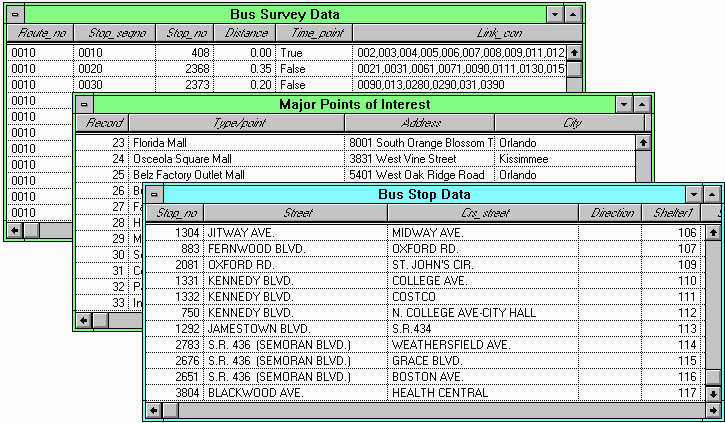
The first and largest database to be developed was a bus stop inventory. Over 4,000 bus stops were entered into a coverage by using either their intersections, addresses or distances from known points. Once this coverage had been completed, it was joined with the route database provided by LYNX. At this point data such as transfer links, connecting links, stop sequence numbers, route names and stop numbers could be incorporated into an application to be provided to customer service personnel. Data locating schools, shelters, and major points of interest around the Orlando area were also collected and integrated into the application.
Exhibit 2. Example of Non-spatial data integrated into the Application
Since LYNX wanted to be able to access the GIS database through ArcView software on the desktops of the customer service representatives it was imperative that the final product provide quick response times and pertinent data when needed. When the project was first being developed, it was decided that ArcView was the software on which to base the final application. However, as the data collection phase progressed, it became obvious that due to the size of the service area and street networks, long regeneration times were going to be experienced after each query. About the time PBS&J began looking for a way to speed up the process the BETA version of Map Objects was being shipped. After some experimentation, it was decided that Map Objects was very well suited for the type of program that was being developed. The query capabilities, ease of graphical interface development, and improved display times made it more suitable for customer service applications.
When using the LYNX application, customer service personnel are able to perform queries to pinpoint the current location of a caller, tell them the bus stop nearest to their location, transfer information, routing information and time schedules. Each of the street files for the three counties in the service area can be displayed separately or in combination with each other and the bus routes. An address matching box was customized so that the operator can enter pertinent data once the caller has identified where they are, and an additional input area exists for a destination. Complete addresses or intersections may be used. Once a query has been run, the program zooms to the extent of both locations which are indicated by point symbols.
When a call has been completed, the service representative logs it using a "call qualification" system. This information is used to track the type of calls and the data requested by each caller. Currently customer service personnel use their telephone number pads to enter a series of codes that describe the previous customer interaction. In order to make the transition to the new application as smooth as possible, PBS&J designed a telephone number pad that appears on the screen after the completion of the call. LYNX personnel can simply click the mouse on the buttons of the pad to enter the information just as if they had used their telephones. These codes are then stored in a log file for analysis at a later time.
Exhibit 3. Customer Service Application Graphical Interface

The final phase of this project involves PBS&J working with other LYNX consultants who are responsible for the preparation of transit-related non-spatial databases. Together we will determine the appropriate methods for integrating any new data with the spatial data sets which were created during the initial phases of this project.
PBS&J has provided some training for LYNX staff and will provide on location support for the customer service representatives as the system is implemented. Instruction on updating the existing databases and making necessary route changes will also be given.
Anyone who has visited the Orlando area recently, or those who live here, know that the growth is going to continue. More hotels, restaurants, and entertainment complexes are constantly being built in order to meet the demand of an increasing population. An efficient transit system is a must if this area is to compete with other vacation destination areas of the country. People need to be able to go from one place to another without difficulty. For residents, a smooth running transit system means that they have an alternative to the daily stress of driving in rush hour traffic, and that they have a reliable way of getting to work, school, or anywhere else they care to travel. LYNX is an affordable, efficient answer to the transit concerns of everyone in the Central Florida area.
Deployment of this customer service application not only effects current procedures, but can also be used as a planning tool for future expansion and development of the LYNX system. An itinerary scheduler, travel planning center, and internet applications are all possible now that critical data is available in digital form. The expanded ability to look at multiple layers of data at the same time will allow the LYNX staff to analyze routes for the most efficient use of resources, keep track of customer amenities such as shelters and benches, and even take a look at risk management issues such as accidents along bus routes.
The customer service program developed by PBS&J will help ensure that LYNX will be able to continue their record of excellent service to the people of Central Florida and those who visit here.
Julie A. Rediker, GIS Analyst
Post, Buckley, Schuh & Jernigan, Inc.
1560 Orange Avenue, Suite 700
Winter Park, Florida 32789
Telephone: (407) 647-7275
Fax: (407) 647-0624