The core of CAATS is the Distributed Virtual Machine (DVM). The DVM represents a portable suite of integrated services, developed in Ada, for building a variety of distributed fault tolerant applications [1]. Constructed on top of the DVM is a collection of ATC application software. These applications include airspace and flight management, recording and playback, and ATC simulation.
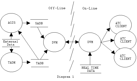
One of the primary tasks of the DVM is to distribute static and dynamic information to client applications. Dynamic information represents real time data fed into CAATS, such as the state of flights as they track through a controller's jurisdiction. Static information represents data, which changes infrequently, such as the location and properties of a NAVAID or the segments and attributes of an airway. The system being introduced in this paper is concerned with the modeling and preparation of the static information for an operational ATC. The off-line data management portion[1] of CAATS consists of a collection of software and activities designed to feed the on-line portion[2] with static data. Diagram 1 shows the high level architecture of CAATS which puts the DVM, its operational clients, and its off-line database in context.
The off-line database contains two classifications of data, and two distinct types of databases. The resource database consists of information, which configures the components of CAATS. Examples are the configuration of a physical or logical network, the setup of controller workstations, or messages presented to a controller. The adaptation database consists of information, which is fed to the on-line system to populate objects, which are then used during the operation of the ATC system. Examples are NAVAIDS, aerodromes and airways.
The two databases supporting CAATS are a spatial database (ArcInfo) and a tabular database (Oracle). This paper will discuss the spatial component and its use of GIS technology.
The purpose of the Aeronautical Geographic Information System (AGIS) is to:
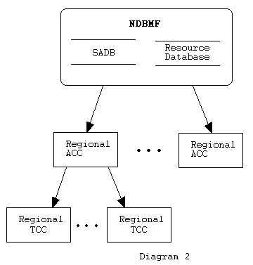
Diagram 2 illustrates the structure and flow of data throughout CAATS.
FIX: Consist of any geographic location or navigation device, which is used by an IFR or CFVR flight in maintaining their filed flight plans. A fix may be an intersection, a geographic location or one of a collection of NAVAIDS.
AERODROME: Consists of any site where a plane may land or take off. This may be as large as a major international airport or as small as a grass strip on the outskirts of a small town.
AIRWAY: Consist of an ordered sequence of FIXES, which define a published path. Airways are analogous to a shipping lane with the addition of altitude. IFR flights file flight plans against airways or portions of airways.
AIRSPACE: An airspace consists of a volume of the atmosphere. Its purpose may be to mark the vertical and horizontal boundary of a jurisdiction, a physical phenomenon or the existence of an activity of interest to a flight.
With the exception of airspaces[3], all aeronautical data are loaded into the SADB from within CAATS, via Oracle into ArcInfo. External data in the form of internationally and nationally published data sets are ingested by the Tabular Data Management Subsystem (TADM). They are parsed, validated and stored into Oracle tables. Views are presented to AGIS, which converts the tabular representation into coverage models, complete with classification, attributes, and symbology.
Non-aeronautical data is used primarily for context and reference on maps and during the creation of airspaces. A subset of this data supported on CAATS is:
Geographic information is provided by external sources in a format that can be directly loaded into a coverage model.
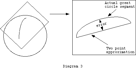
Many GIS applications use local approximations to the earth by projecting geodetic coordinates onto a plane. Errors in position introduced by the planar model are small because the objects under consideration are small or the data is dense. This is not always the case in ATC where the data is sparse and, the spatial extent is large. Errors are deceptive and can imply an unsafe course of action
In AGIS the following geometric primitives are used to describe complex objects:
The problem for ATC comes down to the density of the sampled data. The best course here is to discuss the problem in parallel with an example. An airway segment is represented by a great circle between two fixes. If we project the fixes onto a plane, and then describe the airway by connecting the two points, a substantial error is introduced. In reality, a flight tracking along this airway will sweep out a curve, as shown in diagram 3. The maximum error will occur at the midpoint. This error is largest when the two points have the same latitude. If the latitude is 0, there is no error. As the latitude increases (or decreases), the error increases. Performing explicit over-sampling of the great circle will reduce the error. Each point introduced will decrease the error, which will never vanish, but can be minimized. It now becomes a balance between the issue of safety and the volume of data used to model a phenomenon.
The solution to this problem of geodesy is to reuse components of the on-line ATC. CAATS supports a collection of tools for performing geometric operations on a sphere. The tools are used in a myriad of tasks, such as calculation of the predicted and actual time of flight intersection with airspaces. An interface was developed which allows the AGIS application to call, directly from ARC Macro Language (AML), a subset of the Geometric Services (GEOM) subsystem. The services provided include great circle segment intersection, and small and great circle segment densification. This interface is used extensively throughout the subsystem, initially when data is ingested into the system, but also in the interactive construction of airspaces.
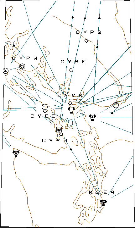
Maps are composed in three phases: preliminary, composition, and de-cluttering. In the preliminary phase, the high level components of the map are specified. This includes the label, the spatial extent of the map, the map projection, the magnetic declination at the map center, and a time period under which the map is considered valid. In the composition phase, the levels of the map and the classes of objects contained in the levels are defined. Levels are generally thematic, containing all objects of a certain class, such as all airways, or a specific type of aerodrome. The display order of levels can be manipulated. In the de-cluttering phase, the objects in the map are tailored to a specific need. This operation centers on removing subsets of data, either by exclusion of individual objects or the clipping out of collections of objects. Tailoring of annotation is supported in the form of exclusion or displacement. An example of a map developed by AGIS is shown in diagram 4.
To support composition, recreation, and copying the map exists in two structures. The explicit and implicit map co-exists as a parallel database. The implicit map is modeled and supported in Oracle. The explicit map is modeled and supported in ArcInfo. During the initial composition of the map, all instructions are recorded in the implicit map and concurrently elaborated in the explicit map. The implicit map exists as a collection of inter-related rows in a collection of Oracle tables, while the explicit map exists as a displayable entity. The copy and recreate operations require only the implicit map and the SADB to exist. From this representation the explicit map can be derived, either in its original form through the recreate operation, or as a new map through the copy operation.
Subsets of aeronautical classes support pick operation on the SIT. The pick operation allows a controller to select the object on the SIT and get additional information on it. During compilation, the pick key is embedded with the spatial information. Software in the on-line world traps this embedded key at pick time, and queries the real time database of the DVM for the most current data associated with this object. For example, a NAVIAD has a schedule of operations, a frequency, and may be shut down temporarily for repairs. When a pick is performed on a NAVAID, the current version of this data may then be presented to the controller.
The map is distributed in two components. The first component is the DDL file. The second component is the preliminary information on the map, which is not captured in the graphics. This information is extracted from AGIS and processed into a Fast Load File (FLF) by TADM. A FLF is the binary image of an Ada object captured as a byte-stream. The FLF is the primary method by which data from the off-line system is distributed to the on-line system. TADM extracts information from the database and calls a client constructor, which returns an Ada object. The object is encoded into a FLF. This FLF is then injected into the DVM, which looks after transmission and delivery of the FLF to the on-line client. The SIT clients receive notifications from the DVM that a set of FLF representing maps is available. The client then retrieves the graphic portion of the map on demand. The DDL portion of the map is not distributed via the FLF method. This is primarily because of the volume of data in this representation. A different mechanism of the DVM looks after synchronizing the DDL and the FLF and distributing it to the on-line world.
With a well-defined spatial model for an airspace, real time spatial relationships, such as containment and intersection may be determined between actual and predicted flights. The properties of these relationships can then be associated with a flight at a particular instant in time. The AGIS manages with four kinds of airspaces:
Static Airspaces: Static Airspaces represent airspaces that are essentially unchanged over time. In general static airspaces are published internationally. Examples are Flight Information Regions, Domestic Airspace and Compass Unreliability Regions.
Special Use Airspaces: Special Use Airspaces (SUA) represent airspaces where restrictions to normal flying are under effect. These restrictions may or may not be scheduled. For example an Alert Area is an airspace where a high volume of pilot training, or unusual aerial activity such as parachuting occurs.
Sectorization Plans: A sectorization plan is used for managing the airspace from an ACC perspective. Each sector represents a subset of the airspace that a controller will manage. Sectors are composed of sub-sectors that can be rearranged to react to changes in the load of traffic.
Radar Coverage: A radar coverage airspace represents the volume of airspace that can be seen by a radar installation. Over a given area, multiple radar sites will provide primary and secondary coverage for aeronautical facilities. Modeling this radar coverage as an airspace allows for the system to adapt to the failure of a radar site.
Airspaces are introduced to the system from an external source in three components: static attributes, vertical geometry and horizontal geometry. TADM ingests the external airspace definitions into tables, validating content and insuring consistency with the on-line representation of airspaces. The horizontal and vertical components are then converted by AGIS into airspace coverage models.
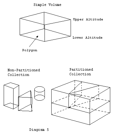
Airspaces are modeled spatially by the simple volume model. A simple volume consists of a closed polygon on the sphere, and an associated altitude interval. Sets of simple volumes are grouped into complex volumes. Collections of volumes model airspaces, and are separated into two classes: partitioned and non-partitioned collections. In a partitioned collection, the spatial relationships between each simple volume are known, and a strict set of geometric rules is applied. In a non-partitioned collection, each volume is essentially stand-alone, and no rules are applied to the collection as a whole, only to the individual volumes.
An application of the region model in ArcInfo and a collection of AML developed algorithms support the creation of volume collections. The following rules are applied to all collections:
If the collection falls under the non-partitioned class, no further rules apply. If the collection falls under the partitioned class then the following additional rules are enforced:
Given the definition of partitioned and non-partitioned collections, airspaces map into the classes as follows:
A general-purpose airspace editor is currently under development. This tool will allow for a user to interactively define both partitioned and non-partitioned volume collections, verify the rules applied against them, and suggest a course of action for correcting any problems. In addition, display tools have been developed to aid in visualizing the three-dimensional properties of the airspace using its two-dimensional planar representation.
Non-Partitioned Airspaces: The geometry of each individual volume is extracted from the coverage model, converted to its spherical grammar representation and added to the GEOM model of the volume collection. No relationships between the volumes are determined.
Radar Coverage Airspaces: The geometry and availability of radar coverage both horizontally and vertically are captured into a grid. Each grid cell represents a patch on the sphere which contains an ordered list of radar sites and altitudes which the radar has a line of sight.
Partitioned Airspaces: This is the most complex volume collection AGIS must deal with. It uses the same grammar as the non-partitioned volume collections, with the additional complication of requiring that all geometrical relationships between the volumes in the collection be determined. This cascades from the low-level relationships between points, curves, and altitudes, up to the more complex arena of open and closed surfaces, volumes, and finally unions of volumes. In addition, the orientation of all objects must be determined, and the construction of geometric primitives such as vertical faces must be minimized.
The output grammar is inserted into what is called a "Black Box" table in the TADM database. This information is extracted as an anonymous stream of data by TADM and encoded into a FLF, which is then distributed to the on-line world through the DVM. The "Black Box" methodology is employed for consistency and minimization of validation. The TADM subsystem is responsible for the creation of all FLF for CAATS. Rather than having AGIS, which is primarily concerned with geometry, deal with FLF creation, TADM applies its well-developed process and software to creating the FLF. The anonymous or "Black Box" approach was used to minimize the repetition of validation. The coverage model and its suite of supporting software perform all verification and validation of the airspace geometry. There is no need for TADM to perform any more consistency checking on the geometry. It is only required to construct the operational model from the contents of the anonymous column, and link the geometry and the tabular attributes together in the Ada object, and ultimately the FLF.
GIS has probed the oceans, the earth's core and surface. It can now be said that GIS has finally left the ground for the atmosphere. The next step can only be upward and beyond to space. The author hopes to see the development of the first Cosmological Information System in his lifetime.
[1] Not a component of the operational ATC system, and concerned primarily with the consistency and correctness of static ATC and configuration data.
[2] The operational ATC system, real time and fault tolerant, concerned with the real time management of air traffic.
[3] The ingesting of airspace data is discussed in section 5.0
[4] For the purposes of clarity of discussion the earth is assumed to be a perfect sphere.
[5] With the exception of the equator, which is a great circle