Two ArcView projects were developed as the first introduction of GIS into Ridgecrest Elementary School in Puyallup, Washington. These projects, a South America geography project and school bond voting pattern maps, were intended to be easy to understand and directly applicable to existing classroom projects and current events. The geography project is generic and could easily be used in other classrooms as an introductory ArcView project.
Done on a volunteer basis, the geography project development was set up for the school with design and data input from the teacher and students. Due to bond campaign restrictions, the voting pattern maps were done exclusively by the GIS professional without student participation; the ArcView project has been made available for classroom review after the election.
The South America ArcView geography project was added to an existing country research project done by sixth grade students. After two months of research, there is a festive two-hour classroom display of papers, art work, food, and music from the country. Parents are invited to attend. The GIS mapping presentation worked nicely into this event. As input into the mapping project, students provided a paragraph about their country, pictures and a paragraph about themselves, and an entry into a spread sheet containing thematic data such as population and literacy rates. The GIS analyst combined the student input with pictures from the countries and national anthems for country hot links and thematic mapping.
The second project, school bond election pattern mapping, was done using election data provided by the Pierce County Auditor, street and precinct data from Pierce County GIS, and 1990 census data. A series of maps were made and provided to the citizen's bond committee. Based on analysis from the maps, an editorial was written taking into account the apparent voting issues from the previous election.
The applications were written mainly with ArcView, Avenue, and Excel. ArcInfo was used to reformat some of the data bases used for the election maps.
An annual tradition for Mrs. Canalles' sixth grade class at
Ridgecrest Elementary School in Puyallup, Washington, is the South
America Geography project. The students work for two months doing
research on the Internet and in the library for their chosen country.
At the end of the two months, students display their research papers
averaging around ten pages, art work, music, and food from their
country in the classroom. Parents are invited to this festive event.
ArcView mapping was added to the 1997 geography project. From a map
of country outlines [1] student data and images were used to make
thematic maps and hot links to each country. Since this was the first
ArcView project for the school, the GIS analyst did all of the ArcView
setup work. Students wrote a summary paragraph about each country,
took digital photos of authors by country, and wrote about-the-author
text files for hotlinks. They were also responsible for entering data
into a spread sheet containing a row for each country and columns
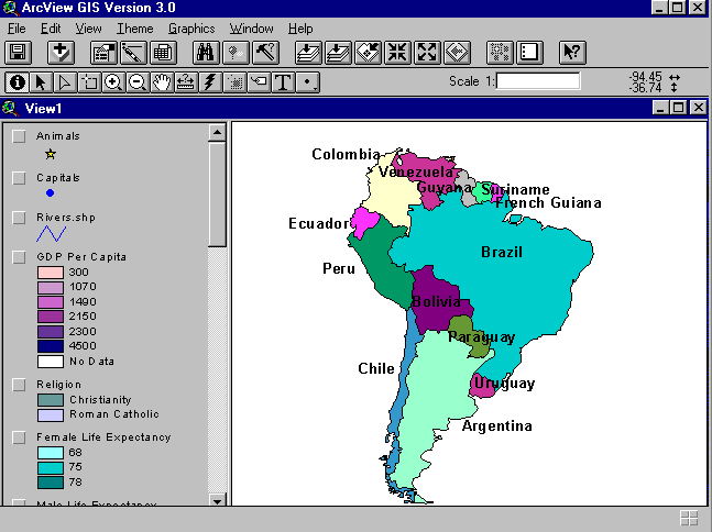
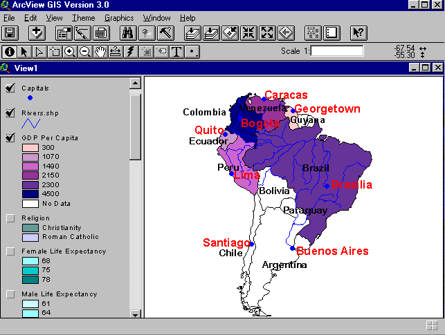
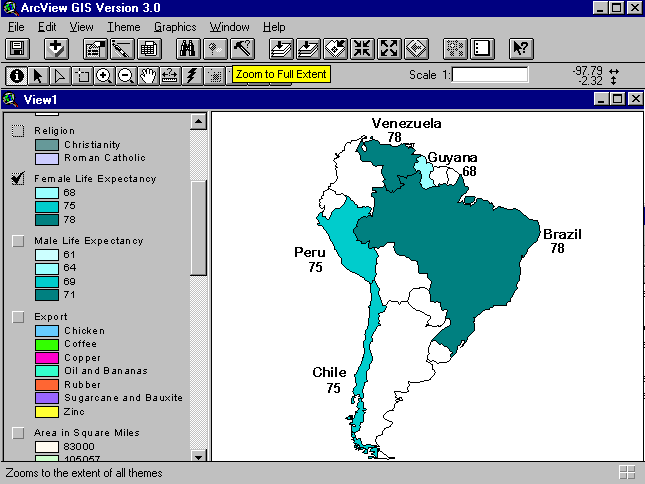
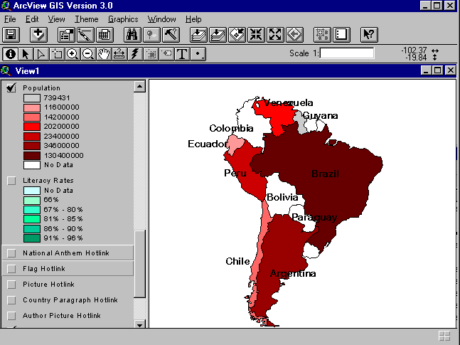
for data that could be used in thematic mapping. Data categories,
chosen by the teacher, were population, gross domestic product per
capita, religion, female and male life expectancies, export products,
area in square miles, national sport, current leader, type of
government, population, and literacy rates. There are many other
possibilities for statistics, such as percent of forest cover,
which can be added in future projects.
Not all of the countries in South America were chosen for reports,
and not every cell of the spread sheet was filled. In the following
map examples, the missing data is usually displayed in white. This
map shows the basic starting point for mapping, just the country
outlines and names:
The hot links for the flag, a picture from the country, and the
national anthem were combined together. This was the first
demonstration done in the class, and it proved to be quite an
attention-getter. Each student wanted to see the flag and hear the
anthem from his or her country.
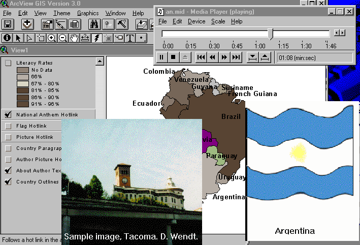
In the above picture, a sample image is shown in place of an actual
Argentina photo, but in an actual student project country images from
the Internet or reference sources can be used.
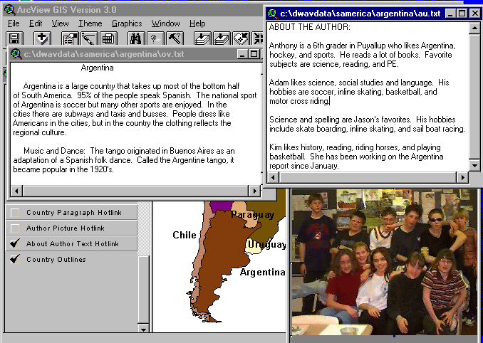
The authors' picture and about-the-author and country
overview paragraphs shown below were provided by the students.
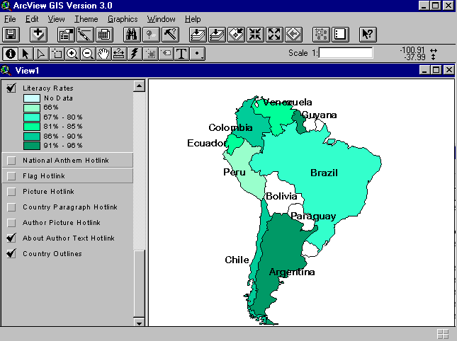
After the hotlink demo, everyone was paying attention, and thematic
mapping was covered next. No changes were done to students' legend
categories from the spread sheet. Following are a few of the maps
that were done:
Project Setup:
To set up the project, first make a directory for the whole project,
such as "samerica." In that main directory, put the map shape files
for the country outlines, main rivers, and any other map themes that
are desired, like climate areas or animal habitats.
The ArcView project file, samerica.apr, should be in this main
directory. The spread sheet
of thematic data with one row per country should go here too. Make
sure that there is one column in it that matches the country key used in
the country shape file so a file join can be done in ArcView. Save
the spread sheet in dbase format (cntryatt.dbf).
In the attribute table for the country shape file, insert 6 items for
the path names to the 6 hot links: national anthem, authors' picture,
about-the-authors text, flag image, country photo image, and country
overview text file. Now, set up one directory per country, using the
country's name. Inside each country's directory, create the following
hotlink files:
Bring up the country attribute file and fill in the path names to
these files. If the project is started from a copy of an existing
one, the file setup should be simple and apparent. There are two
Avenue scripts used, one for hotlinking the midi files and another
for displaying bitmaps. These examples were done on a Windows 95
machine, and changes would need to be made for other computers.
' runpbrush.scr -- Uses Pbrush to display bitmap file
theVal = SELF
' see if the value of the field is not null
if (not (theVal.IsNull)) then
' if the file listed in the field exists, then play the video
if (File.Exists(theVal.AsFileName)) then
' use the path to the video player executable
system.execute("c:\windows\Pbrush.exe "++theVal)
else
' if the file doesn't exist, tell the user
MsgBox.Warning("File "+theVal+" not found.","Hot Link")
end
end
Recommendations and Conclusions:
The ArcView geography project is a great one for getting familiar
with GIS. Basic mapping concepts are included, but the setup is kept
simple. If it is the first project for a school or a teacher, the
GIS professional should do most of the setup work. After reviewing
some of the steps in setting up this project, teachers and students
should be able to do basic ArcView projects on their own, with just
some coaching. In the author's opinion, the geography project could
be made appropriate for grades 4 and up. The sixth graders were
a fun and enthusiastic group to work with. A real advantage of
working with this grade was that they were mature enough to do a
research paper, and being in the same classroom all day meant that
subjects do not have to be chopped up into 1-hour classes. As in
real life, the project could combine skills from many areas, such
as geography, writing, art, music, and computers.
The School Bond Election Mapping Project:
After four defeats at the polls, the Puyallup school bond was
on the ballet one more time in March, 1997. A third high school
was badly needed to meet increasing student enrollment, and a junior
high school needed replacing. To help pass this bond, a proposed
ArcView project would map voting patterns from the failed bond vote
number four, plus census data maps of the area. The original intent
of this project was to involve students, look for clues and patterns
from the maps, and brainstorm how to pass the new bond vote.
However, upon finding out that using school resources to promote
the bond was not legal, the project was taken on by the GIS
professional alone.
Election data was provided by the Pierce County Auditor's office, and
streets and legislative boundaries were provided by Pierce County GIS.
Census data was taken from the 1990 block group statistics. The
voting data was in two parts, county-wide absentee votes
recorded by 4 large polygons, and the rest of the votes, including
vote-by-mail precincts and precincts with polling stations, both of
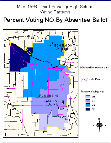
which were recorded by precinct. It was reported that the last
election was lost by the absentee votes. The map of this vote is
one of the most revealing of patterns, and it verifies the statement
about the absentee votes. The new proposed high school
is to be located in the extreme southeast corner of the school
district. On this map, the "no" vote increases with the distance
from the new high school.
A similar voting pattern, although not as striking as the absentee
vote, shows with the precinct data. Notice that the vote-by-mail
districts seem to be more negative than adjacent precincts with polling
places.
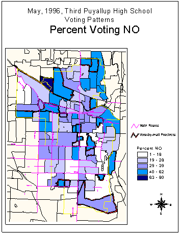
Other election maps produced for the project not shown here include:
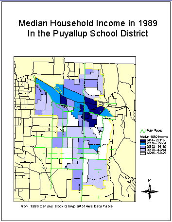
Some of the census block group data was very interesting. The
patterns of low median household income very much looked like
the map of percent of people over 25 with no education beyond
high school. A correlation using Excel was run between low median
household income and the percent of people without college education
using the data from the entire Pierce County area, and the correlation
was -1, a very strong negative correlation. Whether or not it was
valid to correlate summary data can be left up to the professional
social statisticians; however, it is fairly safe to say that with
more education you can earn more money.

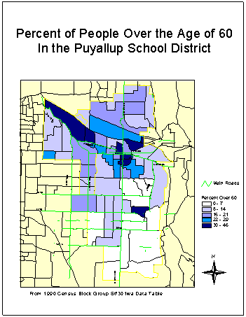
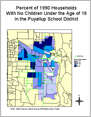
The census map showing the percent of people over the age of 60
did not match the no-vote pattern as much as the map with percent
of households with no children under the age of 18. Not shown
is the map of highest unemployment areas which did not match the
voting patterns.
Conclusions:
Based on information from the maps and data, an editorial was
written promoting construction of the new high school to relieve
crowding in both of the current high schools. District-wide needs,
such as the replacement of Edgemont Junior High in the extreme north
end of the school district, were emphasized. The correlation between
education and income was mentioned in the context of supporting
students in quality education as an investment in their future.
The bond vote was approved with a 62% yes vote, largely due to an excellent
campaign by the citizens' committee and a scaled-down design and lower
cost for the new high school. The maps confirmed previous information
but showed very clearly and quickly the voting pattern from the failed
election. The mapping project was done just before the new election;
the next time it is done, it should be done several months ahead to be
of maximum help to the school district and citizens' committee.
[1] Environmental Systems Research Institute. ArcWorld. Redlands: Esri,
1994.