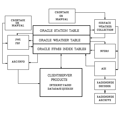
Figure 1. Flowchart of the FFMIS processes.
The state of Florida has led the nation with respect to wildland fire management for many years. New technologies are being investigated that will help maintain and perhaps even increase that lead. In order to more accurately deal with the threat from wildfire, as well as manage the largest open burning program in the country, Florida has designed a wildland fire management system that is GIS based. This new system has integrated some of today's most sophisticated technology. Elements include an Oracle relational database (Oracle Corporation, Redwood Shores, CA), an comprehensive GIS database developed using ArcInfo GIS software (Environmental Systems Research Institute, Inc., Redlands, CA)., and a meso-scale weather model that was developed by the National Center for Atmospheric Research and the Pennsylvania State University called Meso-Scale Model number 5, or MM5 for short.
In addition to the enormous job of integrating the hardware and software, this effort was cooperatively developed by the Florida Division of Forestry, the University of Florida's School of Forest Resources and Conservation, the Canadian Forest Service and Florida State University's Department of Meteorology. Additionally, considerable support has been provided by Environmental Systems Research Institute, Inc. (Esri) and Oracle Corporation. The contributions of all project cooperators have come together to produce a product that is one of a kind, and will, if only half of the expectations are met, assist the wildland fire managers to more safely and accurately accomplish their respective jobs. It will also help other emergency response and land management agencies to obtain critically needed information for them to be able to handle their day-to-day business. As enhancements are added, or become available, we can expect that this system of programs will be made more and more invaluable to the wildland fire managers in Florida. The possibilities for Florida and other parts of the country are endless.
The fire weather and behavior module of the Florida Fire Management Information System (FFMIS) provides core GIS functionality to support the State of Florida's wildland and prescribed fire management programs. This module is based upon the same GIS approaches used by the Canadian Wildland Fire Information System (Lee, 1995). FFMIS spatially models the current and forecast state of surface weather, atmospheric stability, fire danger, fire weather index and fire behavior potential. The following provides a description of the FFMIS fire science models, data management issues and GIS processing and map production.
The surface weather sub-system provides spatial displays of 1300 LST temperature, relative humidity, wind speed and wind direction. Displays of maximum and minimum temperature and relative humidity are also presented as are 24 hour precipitation amounts and the number of days since rain. The source of weather observation data is from 110 weather stations located in and around the state of Florida. Forecast data is provided to FFMIS from the MM5 model at a regular grid spacing of 16 kilometers. These GIS layers provided by this sub-system are the principle inputs to the following models.
The Atmospheric Dispersion Index (ADI) is an integer greater than or equal to one reflecting the efficiency of the atmosphere at carrying gaseous or small particulate matter away from its source. The ADI is based on the Gaussian Plume statistical model (Lavdas, 1986), where a Gaussian distribution of the pollutant concentration is expected in a finite box downwind of the source. The ADI uses surface and upper air (radiosonde) weather observations to estimate a mean wind vector and an upper bound (mixing height) for the turbulent suface layer, in which turbulent mixing aids in pollutant dispersion. Calculations are presently performed at 0100, 0700, 1300, and 1900 LST, and include mixing height, transport wind speed and direction, and the Dispersion Index.
This module partially implements the 1988 version of the National Fire-Danger Rating System (NFDRS) (Deeming, et al 1978, Cohen and Deeming, 1985, Burgan 1988). Outputs implemented for the State of Florida include the 10 hour, 100 hour and 1000 dead fuel moistures; Keetch-Byram Drought Index, Woody Greeness Factor, Ignition Component, Spread Component, Energy Release Component and Burning Index.
The Canadian Forest Fire Weather Index (FWI) System (Canadian Forest Service, 1984; Turner and Lawson, 1978; Van Wagner, 1987) is the basis for modeling and interpreting fire weather. The FWI system estimates forest floor moisture conditions using empirical models driven by the 1300 LST weather observations and forecasts.
In contrast to the NFDRS and FWI systems, the modeling of fire behavior potential provides absolute rather than relative measures of fire business. Using weather (FWI), fuels, and terrain information as inputs, quantitative predictions of fire growth, intensity, fuel consumption and crowning potential are derived. This sub-module is based on empirically developed equations from the Canadian Forest Fire Behavior Prediction (FBP) System (Forestry Canada Fire Danger Group, 1992).
The FFMIS uses geographical, meteorological, climatological, and informative data in its calculations and products available to clients. Station parameters, weather observations and forecasts, and FFMIS index values (ADI, NFDRS, FWI, and FBP) are stored in an Oracle database, which consists of ten tables. The station table remains a fixed size, unless stations are added or deleted, while the weather observation table is dynamic, with hourly observations stored. The FFMIS index tables grow at a slower rate, since the ADI is calculated once every six hours, and the NFDRS, FWI, and FBP once each day. Forecasted weather will likely not be retained, so the forecasted weather table sizes will remain static. Some information is too cumbersome for database storage, such as radiosonde reports and vegetation classes, so is archived in ASCII text files or ArcInfo GRID format.
The Oracle database transactions are served by SQL (Standard Query
Language) , and the driver programs for data collection and index
calculation consist of FORTRAN, PERL, ORAPERL, and AML.
The FFMIS station table consists of weather stations within a radius extending a few hundred kilometers outside the region of interest . Standard station data includes the name, identification number and letters, geographical coordinates, elevation, and timezone. Several informative columns have been included, such as agency (administration district), weather reporting bulletin, and the number of reports received daily. Several other columns are required for specific index calculations, including annual precipitation, climate class, and fuel classes been included for the NFDRS calculations.
A continuous feed of weather data is mandatory for operation of the FFMIS, since automatic generation of GIS products is executed at specific times each day. Surface observations may originate from any station type, although stations providing hourly METAR code are currently utilized, as reports are transmitted via the Global Observing and Telecommunications Network to users worldwide. These reports are transferred from Florida State University to the Division of Forestry, where they are read and added to the weather table. The METAR reports include temperature, pressure, relative humidity, wind, weather type, cloud, and precipitation information. A CRONTASK command initiates weather collection at a specified number of minutes past each hour.
Upper air observations are reported twice per day, at 00 and 12 UTC, and transmitted via the Global Observing and Telecommunications Network to users worldwide. The radiosonde provides wind, pressure, moisture, and temperature profiles with height as the instrument package ascends through the atmosphere. Since a full radiosonde report may include over fifty levels varying with day and location, the reports are archived in encoded form outside the Oracle database. Radiosonde decoding is called from the ADI program, which requires upper air data to enable determination of the atmospheric layer subject to turbulent mixing, and the wind data within that layer.
Satellite-generated, or other GIS datasets may be inconvenient for storage in Oracle tables, so ASCII files or ArcInfo grids and coverages are used. Elevation, fuels, roads, populated areas, and political boundaries provide multi-layered map products, while the FBP and NFDRS programs include the capability to perform gridcell calculations, providing greater detail than interpolation-based processing.
Preliminary calculations must be performed prior to ArcInfo map production. Inverse distance weighting interpolation is performed for stations missing one of more weather observations; this information is then written to the index table after calculation is complete. The ADI requires decoding of radiosonde reports at the time of calculation, since they are not stored in the database. Both the NFDRS and FWI/FBP systems require historical weather data, which is read from the Oracle weather table.
The ADI and NFDRS processes are spawned by the weather collection driver, although they may be run independently. Each hour, the weather collection driver calls the process, which looks in the Oracle Station Table for stations whose corrected UTC time matches a preset selection of local hours. If one or more stations match, the process is run for those stations, and the data is written to Oracle. This results in one run for each timezone represented in the station table.
Once the ADI and NFDRS calculations are normally complete, the FWI and FBP calculations and all ArcInfo map production is activated by a CRONTASK call to the Spatial Fire Management System (SFMS).
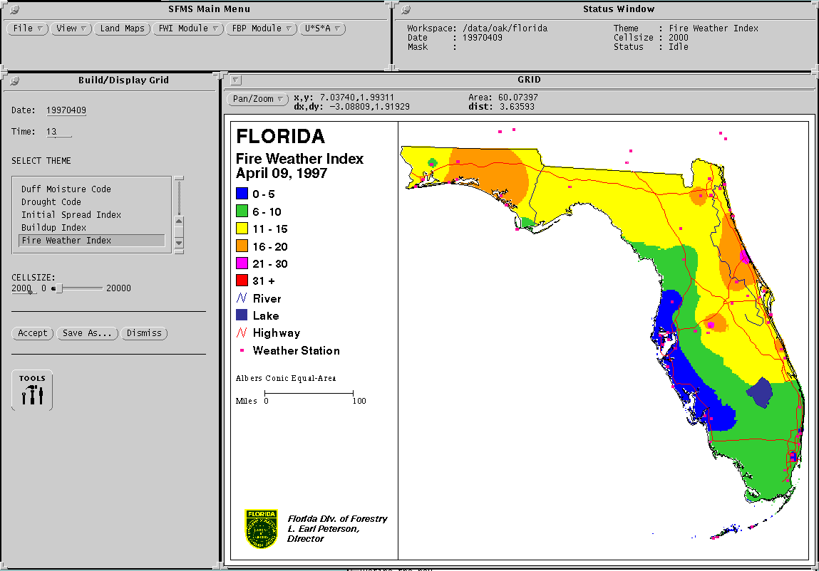
SFMS is a fire management tool which generates maps of fire weather and fire behavior for specific regions. Originally the system implemented the Canadian Fire Danger Rating System (Stocks, et al 1989) but has been extended to incorporate the American National Fire Danger Rating System. It is a collection of integrated software modules, written in ArcInfo's Arc Macro Language (AML). Typically, SFMS is operated in batch mode, running daily to provide a picture of the current day's fire situation. In addition, SFMS has a fully menu driven graphical user interface from which the user can generate ad-hoc maps from current, historical or even forecast data.
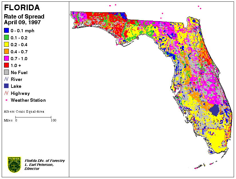
SFMS runs entirely under ArcInfo's GRID module, generating thematic grids representing the many components of each of the Canadian and American fire danger rating systems. All outputs are in GRID format from which maps can be generated using ARCPLOT commands. Creating these grids involves two different methods of processing, depending on type of data being modeled and the type of input data available. The first method is the interpolation of a grid surface from a set of sample data points. Grids representing fire weather are created in this manner. The second method is a cell by cell processing using GRID's DOCELL construct. Grids representing fire behavior are created using this process.
Interpolation from sample points is performed on data that lends itself to this type of processing. Since weather data is usually only available for specific points in a geographic region it is necessary to obtain values for the grid cells between these points. SFMS uses GRID's IDW (inverse distance weighting) function to perform the interpolation of the grid surface. For each cell being analyzed, data from the twelve nearest points is used to interpolate a value for that particular grid cell. The point data is weighted by dividing the value by the square of the distance.
To perform the interpolation, SFMS requires a point data set for the actual values, and an ArcInfo point coverage to provide the spatial information. Using the ArcInfo RELATE environment, a relationship is established between the point data set and the point coverage. SFMS can access the point data set in a number of forms. The data can be contained in an INFO file, an Oracle database table or a DBASE dbf format file.
There are four basic steps performed in the creation of the final grid surface. First the connection between the point coverage and the point data set is established. If the data set resides in an external database management system such as Oracle, a connection is made to the DBMS via ArcInfo's Database Integrator. Next, SFMS ensures that data is available for the particular date of analysis. If so, the IDW function is invoked to create the output grid. As an additional step, the grid can be converted to an integer grid rather than a floating point grid to conserve disk space.
In addition to the final output grid, SFMS has the ability to create a map of the grid in a variety of formats. These include ArcInfo's graphic file format, a Sun Raster file, a Graphics Interchange Format (gif) file or an encapsulated postscript (EPS) file.
The second processing method used by SFMS is cell by cell calculations using ArcInfo's GRID modules DOCELL construct. This type of processing is performed where the input data is readily available on a per cell basis or where interpolation is a poor method for obtaining values for individual cells. The fire behavior components are calculated in this manner since the input fuel type and previously gridded fire weather inputs exist in grid format.
As mentioned previously, all inputs to the FBP system are in grid format. These include grids representing the fuel type, elevation, latitude, slope and aspect as well as the fire weather inputs created by the interpolation process.
SFMS begins by ensuring all required input grids exist and are accessible. In the event that any of the fire weather grids do not exist, SFMS will invoke the interpolation process to create these grids prior to performing the FBP calculations. The calculations are performed for each cell in the analysis region using the GRID modules DOCELL block. The output grids can than be optionally converted to integer grids to conserve disk space.
As with the interpolation process, the final output grids can be saved as maps in any of the available formats mentioned before.
The FFMIS user must be aware of the following problems:
Weather station locations are generally more numerous in populated areas, so large regions of the domain may not be well represented. Florida is a good example, as weather stations are located primarily along the highway system and urban areas. Large gaps make inaccurate interpolation of weather data , as local geographic or meteorological features could be missed.
Interpolation of rainfall is performed using the same algorithm as for continuous fields such as temperature and pressure. Since precipitation events may be localized (showers) or generalized (stratiform), interpolation for a station without a precipitation report may be erroneous.
Loss of the weather data stream cripples the system. Alternate collection methods exist, unless the problem exists in the primary WMO collection/transmission system. METAR and radiosonde reports may be downloaded from various Internet locations, although this method of weather collection backup must be performed manually (as of this writing).
Codes and indexes used in FFMIS has been developed by different researchers in two countries, resulting in an assortment of required units. Units used in the Oracle tables have been tailored to fit the individual needs of each code or index, with the units converted to a standard only during ArcInfo map production. This means a user viewing maps may see different units than when querying the database.
As the weather table grows, query time increases. It is recommended that a procedure be implemented to archive historical data keeping relatively fewer rows in the operational database table.
An additional feature of SFMS is to make the maps available for viewing on the World Wide Web. Unfortunately this involves generating the maps in a format acceptable by various web browsers, such as gif or JPEG. Since ArcInfo does not directly support these file formats it was necessary to develop a workaround to create these graphics files. The workaround involves saving the maps as encapsulated postscript (EPS) files and converting them to gif's using Gnu Ghostscript and the NetPBM (PBMPlus) graphics toolkit. This process has run flawlessly, the only drawback being the lower quality of the gif files produced due to the original, non-graphical, EPS format.
The data provided by the Fire Weather Forecast and the Fire Weather and Behavior Modeling components are combined with sophisticated GIS analysis and database capabilities in these modules to provide DOF duty officers with up-to-date information for decision-support. The duty officers are responsible for issuing Open-Burning Authorizations to the public, as well as for coordinating suppression response in the event of a wildfire. They currently use computers to assist with issuing authorizations, however, several shortcomings have been identified in the system.
The existing DOF Open-burning Authorization System uses dedicated
computer terminals connected to a mainframe computer in Tallahassee,
FL to provide Duty Officers (DO) in each district with the ability
to enter and view information for open-burning authorizations
stored in a central database. Currently, smoke-sensitive areas
are designated in the database as sections from the Public Land
Survey (Section, Township and Range) where a smoke-sensitive feature,
such as a hospital or airport, exists. The sections are flagged
in the database to prohibit any burning authorizations from being
issued for the entire section. There are several drawbacks to
this approach: a) the exact location of the smoke-sensitive feature
within the section is not known; b) the effects of smoke from
an adjacent, non-flagged section are not considered; and c) the
weather conditions, such as wind direction and dispersion index,
are not taken into consideration. In addition, the DO has little
indication of the level and spatial distribution of burning activity
across a district on a given day.
Response to wildfire incidents is based primarily on the experience of the District personnel. Fire suppression resources are mobilized and managed using a magnetic wall map to indicate their location as well as incidents of wildfires in the District. In both cases, information on location of authorized burns, wildfires, and available suppression resources across District boundaries is inadequate. The use of a GIS-based approach to issuing open-burning authorizations and dispatching wildfire suppression resources has been identified as a means of overcoming the limitations of the current system.
To address some of these drawbacks a new Enhanced Open Burning Authorization and Wildfire Suppression System is being developed by the University of Florida and DOF for GIS-based open-burning authorization and computer-assisted dispatch. This prototype system is designed around a client-server computer network linking the central UNIX server in Tallahassee to remote client PCs at each district office via the Internet. The central server maintains a database for open-burning authorizations, wildfire incidence reports, as well as the daily fire weather forecast and fire behavior data from the previously discussed components. Each remote client PC runs a software application consisting of two decision support modules: a) a module for issuing open-burning authorizations, which incorporates GIS, spot weather forecasting and smoke dispersion modeling to determine the potential effects of a proposed burn before a permit is issued; b) a module designed to compile and disseminate information for timely and efficient allocation of available resources to suppress wildfires.
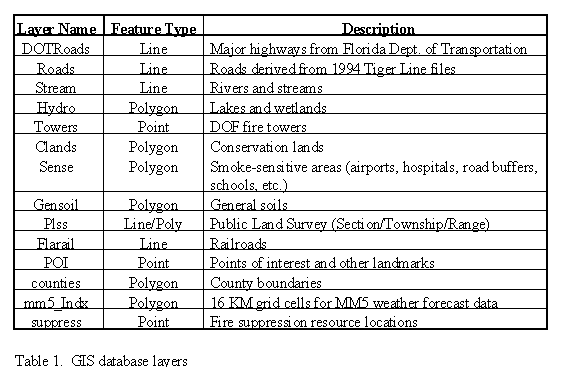
Two main databases are used to support this application. The first is an Oracle database on the central server in Tallahassee provides the application with data for current weather conditions, as well as fire behavior parameters, such as dispersion and drought indices. In addition, the database provides a central repository for all information related to open-burning authorizations and wildfire incidence reports. The second is a GIS database residing locally in each district and consisting of multiple thematic map layers (Table 1). These layers are used in displaying clear and accurate maps of a DOF District. The individual GIS data layers have been obtained from a variety of sources including, the US Census Bureau, Florida Department of Transportation, Florida Department of Environmental Protection, Florida Department of Community Affairs, US Natural Resource Conservation Service (formerly the Soil Conservation Service), digital satellite imagery, aerial photography and Global Positioning System (GPS) surveys
The client software application is organized into two main modules: a) Open-burning Authorization and b) Computer-Assisted Dispatch. The primary module is the Open-burning Authorization since it is used more frequently than the Computer-Assisted Dispatch. Its user-interface is designed to follow the sequence of operations, beginning with a telephone call requesting an open-burning authorization and ending with approval or denial (fig. 1). The Computer-Assisted Dispatch user-interface follows a similar sequence beginning with a report of a wildfire and continuing through resource mobilization, coordination and fire suppression (fig. 2).
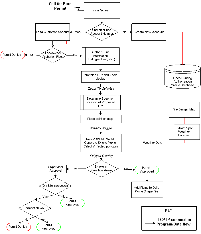
Figure 4. Schematic diagram of Open Burning Authorization interface
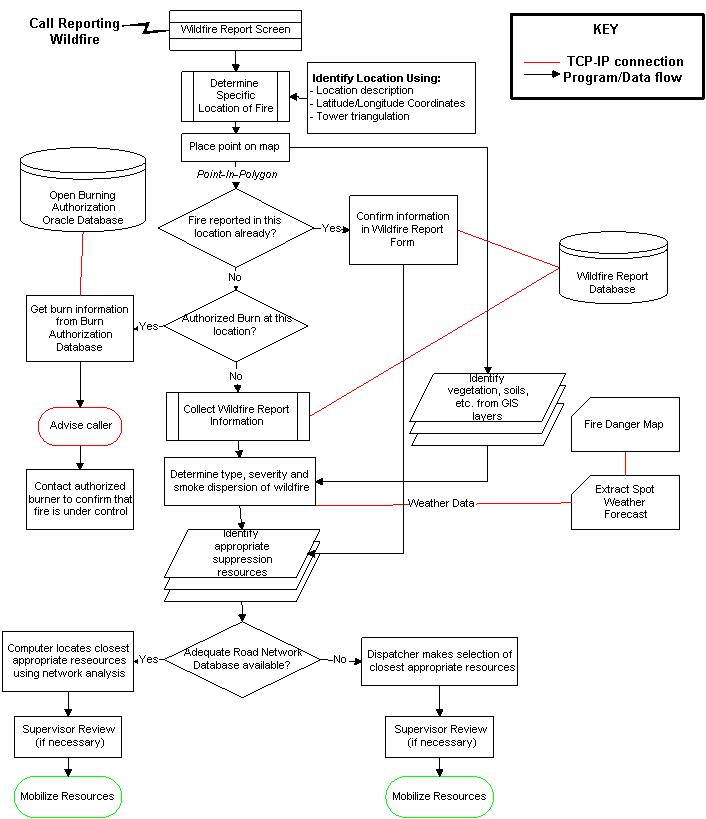
Figure 5. Schematic diagram of Wildfire Reporting interface
The application is based on Microsoft Visual Basic 4.0 Professional, and makes extensive use of the Object Linking and Embedding (OLE) capabilities of this programming language. In addition, two custom OLE controls (also called Active-X controls) are used to provide specific capabilities within the application. The first is MapObjects by Environmental Systems Research Institute, Inc. (Redlands, CA). MapObjects components provide tools for displaying and querying ArcView shapefiles and ArcInfo coverages. These tools allow embedding advanced GIS mapping and analysis capabilities within the context of another software application. The second custom control used is OracleObjects by Oracle Corporation (Redwood Shores, CA). OracleObjects tools provide common programming languages, such as Visual Basic, with robust capabilities for accessing data in local or remote Oracle databases. The use of MapObjects and OracleObjects in this application facilitates the development of a simple, efficient user-interface for performing complex tasks, such as GIS analysis and accessing large remote databases.
The Open-burning Authorization user-interface consists of an electronic form (fig. 3) that is used by the DO to issue Open-burning Authorizations to the public. The form allows the DO to query the database using a customer name, account number or telephone number and then retrieve account information, including a list of all previously issued authorizations. After confirming account information, a new authorization may be issued or a prior authorization, such as one from the previous day, may be continued. The form also allows the DO to add a new customer to the database or revise the information for an existing customer.
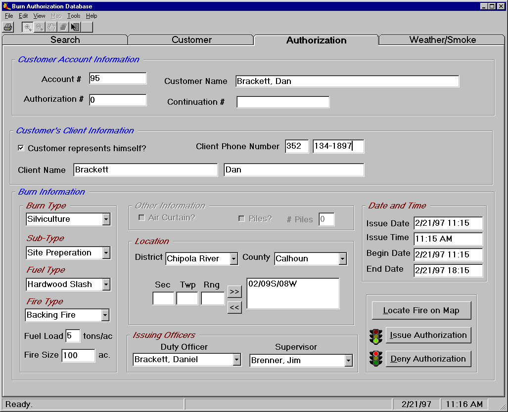
Figure 6. Authorization tab of the Open Burning Authorization interface
Prior to issuing an authorization, the DO enters information,
such as section/township/range, type of burn, fuel type, acreage,
date and time, into the electronic form. Next, a map showing GIS
data layers, such as roads, lakes, streams, landmarks, conservation
lands, cities and section lines, is displayed on the screen and
is automatically adjusted and scaled to the location identified.
The DO identifies the precise location of the burn by clicking
on the map with the mouse. Subsequently, the application queries
the weather forecast information for that specific location and
retrieves relevant data, such as wind speed, wind direction and
mixing height. Weather forecast data are updated twice a day but
provide predictions for three-hour periods between updates.
The data, along with information on fire type and size, are transferred into the smoke dispersion model VSMKGS (Harms, Lavdas and Saveland 1995). Next, the model is run and the resulting plume is displayed on the screen as a set of three isopleths denoting different concentrations of smoke particles in the air. Finally, the application performs a GIS overlay analysis to determine if any of the isopleths intersects a buffered smoke-sensitive area. If so, a red alert appears on the computer screen notifying the DO that Supervisor's approval is needed before issuing the requested open-burning authorization (fig. 4). 500 meter buffers are automatically applied to sensitive areas by the system (state highways use 150 meter buffers; interstate highways use 300 meter buffers).
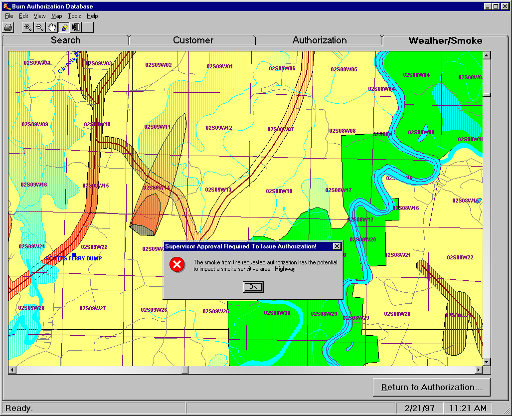
Figure 7. Example of predicted smoke plume from a requested open burning authorization
Each smoke plume on the map is linked to the corresponding authorization in the database allowing the DO to retrieve an authorization by clicking on the plume itself. All smoke plumes for a given day are stored in a shared file so that each DO can simultaneously view all authorizations for that day. Smoke plume files are archived for future reference and validation purposes. This is extremely important for handling possible liability issues.
Like the Open-burning Authorization module, the Computer-Assisted Dispatch user-interface depends also on an electronic form to access and query the Oracle database and interact with the GIS map. Upon receiving notification of a wildfire, the DO selects "Wildfire" from the Authorization module to load the appropriate form. The DO would then collect relevant information about the fire, including the general location, the type of fire and person reporting. Next, the DO identifies the location of the fire on the map by clicking on the location with the mouse. Distance and azimuth information provided by one or more fire towers can be used to aid in pinpointing the fire location (fig. 5). Also, Latitude-Longitude coordinates provided by a spotting plane equipped with GPS can be used for the same purpose. All existing authorized burn plumes are displayed on the map, allowing the DO to quickly determine whether the reported wildfire is an authorized fire. If this is the case, the DO can click on the plume to retrieve the authorization for that fire to find out when it was scheduled to be completed, or perhaps contact the individual responsible to confirm that the fire is under control.
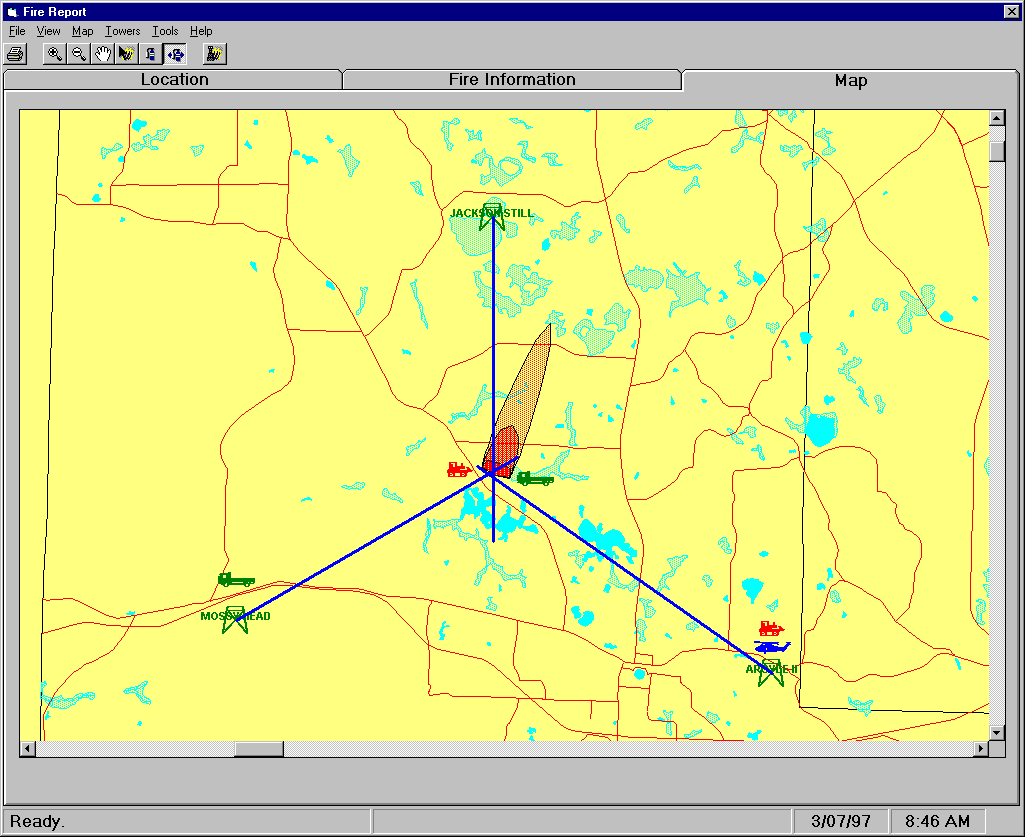
Figure 8. Wildfire Reporting interface showing fire tower spotting vectors, closest available suppression resources and predicted smoke plume
In the event that the reported fire is not an authorized one, the system will query the GIS database to retrieve information on the conditions at the fire site, such as soil type, vegetation type, fire danger rating and weather parameters. The size and direction of the resulting smoke plume is displayed on the map as in the Open-burning Authorization module. The application will alert the DO if the smoke from the fire is likely to reach smoke-sensitive areas. In addition, the system allows the DO to view current locations and status of all fire-suppression resources, such tractors, water trucks, aircraft and personnel in the District. The DO may relocate resources on the map when they are dispatched to a fire by using the mouse and dragging each one of them to a new location. Fire suppression resources may be tagged as "In Service" or "Out of Service" to indicate their availability for responding to a wildfire. The application allows the DO to dispatch the closest fire suppression resources based on fire type, magnitude, proximity to populated areas, rate of spread and site conditions.
The ultimate objective of the Division of Forestry's new GIS-Based
Fire Management systems is to provide quality service to the public
and to minimize the harmful effects of smoke from open-burning,
as well as minimize the loss of human life and property as a result
of wildfires. This is especially important in Florida where urban-rural
interfaces are highly dynamic, mainly due to increases in population.
Application of these innovative decision-support systems will
greatly enhance the ability of the Florida Division of Forestry
to suppress wildfires and handle open-burning authorizations throughout
the state.
The systems described here will undergo extensive testing to identify
areas where improvements or enhancements are needed. In addition,
it must be determined if certain aspects of the system will be
effective under field conditions. For example, it is unlikely
that all persons requesting an open-burning authorization will
know the fuel type and load for their respective sites. A simpler
classification scheme such as low, medium, and high fuel quantity,
or calculation of an approximate fuel load based on the last burning
date for the site (if applicable) may be necessary. Testing is
also essential to determine if Duty Officers can quickly locate
the site of a proposed open-burn based on only a few questions
to the caller.
A number of enhancements to these system are already under consideration.
Wildfire dispatching activities may be aided by the use of vehicle-mounted
Global Positioning System (GPS) receivers to keep track of fire
suppression resources in real-time. Utilizing new high-resolution
satellite imagery could provide the system with timely and cost-effective
updates on vegetation, fuel loads, and land use/cover information
for the GIS database. The use of a high performance, server-based
GIS database is also being investigated to facilitate central
GIS data administration and, by storing map data in contiguous
layers, to reduce the effects of District boundaries on GIS analyses.
Alexander, M.E. and W.J. De Groot. 1988. Fire behavior
in Jack Pine stands as related to the Canadian Forest Fire Weather
Index System. Canadian Forest Service, Northern Forestry Centre,
Edmonton, Alberta. Poster (with text).
Brenner, J. and D. Wade. 1992. Florida's 1990 Prescribed
Burning Act. Journal of Forestry 90(5):27-30.
Brenner, J. 1995. Florida's solution to liability
issues. USDA Forest Service General Technical Report PSW-GTR
158:131-138. Pacific Southwest Research Station, Berkeley, CA.
Burgan, R.E. 1988. 1988 Revisions to the 1978 National
Fire-Danger Rating System. USDA Forest Service Research Paper
SE-273, US Department of Agriculture, Asheville, North Carolina.
Canadian Forest Service. 1984. Tables for the Canadian
Forest Fire Weather Index System. For. Tech. Rep. 25, Environment
Canada, Ottawa.
Deeming, J.E.; Burgan, R.E.; Cohen, J.D. 1978. The
National Fire-Danger Rating System - 1978. USDA Forest Service
Gen. Tech. Rep. INT-39, US Department of Agriculture, Ogden, Utah.
Harms, M. F., L. G. Lavdas and J. M. Saveland. 1995.
A GIS interpretation of VSMKGS. Proceedings 15th Annual
Esri Users Conference. June, 1995, Palm Springs, CA. Environmental
Systems Research Institute, Inc. Redlands, CA.
Lavdas, L.G. 1986. An Atmospheric Dispersion Index
for Prescribed Burning. Research Paper SE-256, US Department of
Agriculture, Macon, Georgia.
Van Wagner, C.E. 1987. Development and structure
of the Canadian Forest Fire Weather Index System. For. Tech. Rep.
35, Canadian Forest Service, Ottawa.
Wade, D. and M. Long. 1979. New legislation aids
hazard reduction burning in Florida. Journal of Forestry
77(11):725-726.
Wade, D. and J. Lunsford. 1989. A guide for prescribed fire in southern forests. USDA Forest Service Technical Publication R8-Tp11, Region 8, Atlanta, GA.
James Brenner, Fire Management Administrator
Florida Division of Forestry, Burea of Fire Protection
Tallahassee, FL
Phone: (904) 488-6111
E-Mail: brennej@doacs.state.fl.us
Rod M. Suddaby, Information Systems Specialist
Canadian Forest Service,
Northern Forestry Center
Edmonton, Alberta
Phone: (403) 435-7246
E-Mail: rsuddaby@nofc.forestry.ca
Richard J. Carr, Information Systems Specialist
Canadian Forest Service,
Northern Forestry Center
Edmonton, Alberta
Phone: (403) 435-7257
E-Mail: rcarr@nofc.forestry.ca
Bryan S. Lee, Project Leader, Fire Management Systems
Canadian Forest Service,
Northern Forestry Center
Edmonton, Alberta
Phone: (403) 435-7303
E-Mail: blee@nofc.forestry.ca
Daniel P. Brackett, GIS Programmer/Analyst
School of Forest Resources and Conservation -
GIS, GPS and Remote Sensing Laboratory
University of Florida, Gainesville,
FL 32611
Telephone: (352)846-0884
Fax: (352)846-1277
E-Mail: dan@aris.sfrc.ufl.edu
Loukas G. Arvanitis, Professor
School of Forest Resources and Conservation -
GIS, GPS and Remote Sensing Laboratory
University of Florida, Gainesville,
FL 32611
Telephone: (352)846-0887
Fax: (352)846-1277
E-Mail: lga@aris.sfrc.ufl.edu