Kjell Johansson & Ismo Laitakari
Digital Revolution of Navigation -
Exploiting ECDIS and Production of
Electronic Navigational Charts
Abstract
As in many other areas, electronic charts have made their way
into the world of hydrography and navigation. Next year the first
ships can throw away their paper charts and start to navigate
with systems that uses electronic charts instead. The term for
these systems is ECDIS (Electronic Chart Display and Information
System). ECDIS does not only consist of a computer with a software
for displaying the chart, it involves a lot of other elements,
e.g. GPS/DGPS positioning device, interfaces to gyro and logs.
Since ECDIS systems and used ENC (Electronic Navigational Chart)
data are quite complex , a number of standards have been produced.
There are technical specifications and display standards for
ECDIS, and also ENC product specifications and standard for the
exchange format of the data. The last ones are known as S-57,
and for the moment it is out in its third edition.
Even if ECDIS are rather complex systems they are "stand-alone"
systems on one ship, there is no interaction with other ships
or traffic control centres. Among other countries, Sweden and
Finland take active part in the development of a way to
manage this interaction with Vessel Traffic Service Systems (VTS)
and Environmental and Traffic Information Systems (ETIS).
National hydrographic offices are explicitly responsible for production
and authorisation of ENC data in their waters. In Finland and
Sweden this task has been tackled by a joint development project
for Hydrographic Information System (HIS). Hydrographic offices
are also responsible for delivery of ENC data and updates to
customers (i.e. ECDIS operators) in a reliable and cost-effective
way. The United Kingdom and Norway have established Northern Europe
Electronic Navigational Chart Coordinating Centre (RENC/NE) for
commercially-based service for the storage and distribution of
ENC data. These services will be made available on CD ROM, ISDN,
Inmarsat B High Speed and GSM mobile telephones. Both Sweden and
Finland have joined the RENC/NE and are working in the related
development projects.
Historical Background
Producers of nautical charts have a long tradition of global co-operation.
The International Hydrographic Organisation (IHO) with its headquarters
(IHB, B for Bureau) dates back to the early 1920's. The overall
goal has always been to produce nautical charts and publications
in a similar manner to promote safety at sea. Exchange of chart
information between countries and standardisation of different
products are important topics for the co-operation within IHO.
IHO have also taken active part in the establishment of international
rules and laws regarding the use of charts and publications in
the maritime transport sector.
As the result of the technological development during the 1980's
the hydrographic community became aware of the future demand for
nautical charts in computer assisted navigational systems. This
awareness lead to a first meeting in Canada where this topic was
discussed. After this a lot of meetings have taken place, work
groups have been put together and standards have been produced.
All this has lead to the concept of ECDIS (Electronic Chart Display
and Information System
Standards
The overall standard is called 'IMO performance standard for ECDIS'
and is a framework for the concept ECDIS. This was ratified in
November 1995, and says that ECDIS can replace the papercharts.
Other standards are:
- Specifications for Chart Content and Display Aspects of ECDIS
(IHO S-52)
- IHO Transfer Standard for Digital Hydrographic Data (IHO S-57)
- Electronic Chart Display and Information System - Operational
and Performance Requirements Methods of Testing and Required Test
Results (IEC 1174)
Chart content and display standard (S-52)
This standard defines the content of the charts and also how the
charts should be displayed on the screen. Among other things it
consists of a presentation library. This standard will assure
that the charts will look the same in all systems.

Figure 1. Extraction from test database shown according to S-52
Transfer Standard (S-57)
This standard consists mainly of the following parts:
- Theoretical background, definitions and conceptual model.
- Object Catalogue, which describes all allowed objects; who
they are , their definitions and which attributes that are allowed
for the objects.
- Attribute Catalogue, which describes all allowed attributes;
who they are, their definitions and in some cases also what values
that are allowed.
- Description of the transfer format.
- Product specifications, describes what objects and attributes
that are allowed for the different products. ENC (Electronic Navigational
Chart, data to the ECDIS-systems) is one product. S-57 also deals
with exchange of paper charts as well as survey information.
The standard is out in its third edition (the first one was ratified
in 1992). This standard assures that all countries (that adapts
this standard) will deliver data in one and the same format. One
do not want to have a situation where every country have their
own format.
Performance requirements (IEC 1174)
This standard defines the technical demands on the system. It
also defines what tests should be done when certifying a system
as an ECDIS (as well as the expected results of the tests).
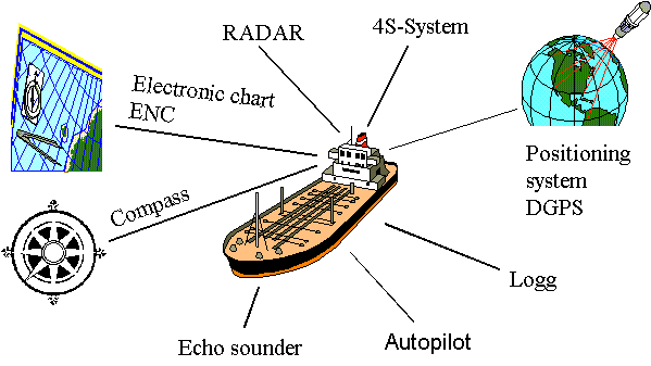
Components of ECDIS
An ECDIS system does not only consist of a computer with a software
for displaying the chart, it involves a lot of other components.
Examples of these components are positioning system and function
to log information about course, speed, position and imported
data. Examples on other components that can be incorporated are
radar, echo sounder and compass.

Figure 2. Components in an ECDIS system
ECDIS and future developments
For the moment the functionality of ECDIS is "stand alone"
on one vessel. It does not deal with interaction between vessels
or between vessel and traffic control centres. This is one of
the developments that the Swedish and Finnish Maritime Administration
are taking active part in. The system that the two HO's are involved
in is a system with so called 4S-functionality (ship-to ship,
ship-to-shore). This system can be described as an information
deliverer (through radio transmissions). The system sends out
information to other ships and to traffic control centres. The
information that is send out contains of the ships position, identification,
name of the ship, tonnage, cargo, target harbour, speed etc. This
will be of great help when it comes to preventing collisions since
other ships that use this system will have more accurate information
about the surrounding traffic.
Another name of a traffic control centres is Vessel Traffic Centres
(VTS). These centres are monitoring the traffic in a certain area,
i.e. areas with very dense traffic, important fairways and harbours
etc. The first VTS in Sweden is situated in Malmö (on the
south-west coast). Its task is to control the traffic during the
construction of the bridge between Malmö and Copenhagen,
and later during operation of the bridge. Naturally the VTS will
use digital nautical charts for display of the vessels.
ENC - Electronic Navigational Chart
What does ENC stand for?
Although an ECDIS is a remarkable instrument, there can not be
any operational ECDIS installations onboard without proper digital
chart data to be displayed. In order to allow ECDIS become a real
substitute for a paper chart under the Safety at Sea convention
(SOLAS) set by the International Maritime Organisation (IMO),
it is necessary to establish:
- production of official1
Electronic Navigational Chart (ENC)2
data
- infrastructure to deliver ENC
- updating service
1 national Hydrographic
Offices (HO) are exclusively responsible for production and authorisation
of ENC data in their waters
2 only data, which conforms
to IHO S-57 standard edition 3, can be considered as ENC
What makes ENC so special?
An ENC is a presentation of hydrographic and navigational information
in digital form. ENC is vector data, which is composed of points,
lines and area features with detailed attributes. From the relationships
between these (points, lines and areas) and ship's features (speed,
draft, course) it is possible for an ECDIS system to intelligently
detect and alarm the navigator of possibly dangerous situations.
The main technical characteristics of the S-57e3 compliant ENC
are:
- ENC data must be encoded using chain-node topology, duplication
of coincident linear geometry is prohibited.
- The horizontal datum must be WGS 84 and no projection is used
- Only binary implementation must be used for ENC. The
use of compression algorithms is prohibited, but ENC
data may be protected from unauthorised access by the use of encryption
algorithms.
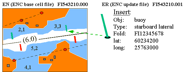
- S-57e3 allows for feature-based incremental updating of ENC.
Since each object and attribute as well as each geometric element
are assigned with unique identifiers, update files containing
commands to insert, delete or alter specific features can be incorporated
to the existing ENCs in the ECDIS systems without need for changing
the whole ENC cell. This provides a great saving in data volume
involved in an updating process. (Figure 3.)

Figure 3. A rough example of an incremental updating of ENC
ENC running the gauntlet
The main constraint affecting the exploitation of ECDIS is still
the lack of official data conforming to the S-57e3. Private sector
is moving ahead with non-official raster and vector data (which
do not meet the criteria for paper-chart-equivalency) and HOs
around the world may have difficulty later winning the battle
of navigators' souls.
Reasons for this state of affairs are at least three-fold:
- S-57e3 standard was officially accepted very late, November 1996
- Since both applicable data structure and product specifications
state very complex rules for ENC, requirements for the ENC production
system development are extremely high.
- It has become evident that HOs only seldom have needed resources
and knowledge in terms of in-house ENC production system development.
Therefore many HOs are in hands of software suppliers.
HIS solution for ENC production
Finland and Sweden have tackled this problem by a joint development
project for Hydrographic Information System (HIS). It will be
based on a client-server implementation of the Esri software and
will be built with custom programs and commercially available
software components ArcView, SDE, ArcInfo and Oracle.
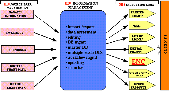
HIS project will, among all its other tasks (Figure 4.), cover
the requirements for the ENC production by developing tools and
processes for extracting appropriate features from HIS central
data storage (= seamless SDE database containing all feature
objects and spatial presentation to them) according to the predefined
ENC product definitions (e.g. cell boundaries) to ENC data sets,
and by processing these further into IHO S57e3 compliant transfer
files.

Figure 4. ENC production line as a part of the Hydrographic
Information System concept
One ENC file will contain data within a defined geographical area,
the cell. Since HIS is based on a seamless data base, special
care has to be taken of mapping between HIS Feature identifiers
and ENC output file specific Record identifiers. It must also
be possible to issue updates also for features that have been
split by cell boundaries. Final file conversion must also include
creation of data set descriptive records, which contain meta data
i.e. information that is specific to the file, e.g. description
and location of the real-world entities. S-57 Transfer file (ENC
data set resulting of the conversion) must be stored to appropriate
directory as a base cell file (EN) or update cell file (ER).
Firm Quality Control guarantees the safety of navigation
For testing the contents of the data, a reference model
will be implemented with which the data can be compared. It defines
the relations between objects of two classes. The
spatial relation check will check all spatial relations
contained in the data and raises alarm if any problems exist e.g.:
- landmarks in water
- submarine cables on land
- depth contours crossing
- depth areas not closing
For testing the conformance to S-57e3 structure and ENC product
specifications, an external ENC validation tool will be used.
The ENC production line will be controlled by a workflow management
system. Procedure descriptions are stored as flow diagrams and
stored in a workflow library. ENC operator actions are guided
by these procedure descriptions and job status reports are always
available to system administrators and authorised users.
Never-ending story
EN -production can start only after a sufficient amount of appropriate
data has been registered and committed to HIS databases. Source
data can be based on up-to-date digital survey data as well as
on older survey documents. The work does not finish when a full
ENC coverage has been achieved. Since the reality keeps on changing,
HOs are obliged to get these changes published as ENC updates
regularly, e.g. on once a week basis.
ENC services
How to reach the navigator on-ship?
Hydrographic offices are also responsible for delivery of ENC
data and updates to customers (i.e. ECDIS operators) in a reliable
and cost-effective way. The IHO-committee for ENC Database has
developed a model for a distribution network for ENC services.
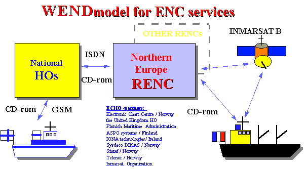
This World ENC Database (WEND) -model proposes a number of Regional
ENC Co-ordinating Centres (RENCs) that are responsible of storing
and distributing chart data and updates to on-ship-users (Figure
5). The United Kingdom and Norway have established the world's
first co-ordinating centre, the Northern Europe RENC (RENC/NE)
for commercially-based service for the storage and distribution
of ENC data. Both Sweden and Finland have joined the RENC/NE
among 9 European HOs, and are working in the related development
projects for building of a multi-national infrastructure where
hydrographic offices co-operate.

Figure 5. WEND model and the ECHO partners
European Chart Hub Operations (ECHO) -project
ECHO is an international project started in April 1996 and scheduled
to last for two years. The aim is to demonstrate the provision
of a complete distribution and update service for ENC. The activities
are partly funded by the European Commission, and the service
is intended to be fully compliant with the IHO WEND-model.
ECHO will establish a telematics infrastructure to link Hydrographic
Offices (HO), a Regional ENC Centre (RENC) and the end-users (ECDIS)
to disseminate electronic chart and related information. An ENC
Service Specifications will be developed defining the basic transactions
that can take place between the data distributor and end user.
They cover:
- requests and deliveries of ENC cells and updates
- services related to product availability, status and coverage
- services to receive decryption permits to access ENC information
These services will be made available on ISDN, Inmarsat B High
Speed, GSM mobile telephone network and CD-ROM. ECHO architecture
incorporates the possibility of encrypting the data during transmission
and will implement the necessary key handling, digital signature
and distribution mechanisms to support this. The project includes
sea-trials in the North Sea and Baltic Sea using two multi-purpose
ice-breakers and an arctic oil tanker provided by the Finnish
Maritime Administration and a Finnish oil company NESTE to test
the infrastructure and services.
Author Information
Kjell Johansson, System Developer, ECDIS Co-ordinator
Swedish Maritime Administration
Hydrographic Service
S-601 78 Norrköping
Sweden
Telephone: +46 11 19 13 43
Fax: +46 11 13 39 03
E-mail: kjellc.johansson@shipadm.se
Ismo Laitakari, M.Sc, ENC production
Finnish Maritime Administration
P.O. Box 171
FIN-00181 Helsinki
Finland
Telephone: +358 204 48 4407
Fax: +358 204 48 4620
E-mail: ismo.laitakari@mkl.fi


