Allen W. Hightower, Maurice Ombok, Richard Otieno, Richard Odhiambo ,Aggrey J. Oloo, Altaf
A. Lal, Bernard L. Nahlen, and William A. Hawley
A Geographic Information System Applied to a Malaria Field Study in Western Kenya
Abstract:
This paper describes use of the global positioning system (GPS) in differential mode (DGPS) to
obtain highly accurate longitudes, latitudes, and altitudes of 7,209 houses, 65 schools, 110
churches, 9 health care centers, 70 major mosquito breeding sites, 7 shopping areas, major roads,
streams, the shore of Lake Victoria, and other geographic features of interest associated with
longitudinal studies of malaria in 76 villages in western Kenya. The area mapped encompassed
approximately 192 square km and included 42.0 km of roads, 54.3 km of streams, and 15.0 km of
lake shore. Location data were entered into a geographic information system for map production
and linkage with various databases for spatial analyses. Spatial analyses using parasitologic and
entomologic data are presented as examples. Background information on DGPS is presented
along with estimates of effort and expense to produce the map information.
Introduction
Analysis of spatial relationships is fundamental to epidemiologic research. Although affordable
geographic information system (GIS) software has simplified this effort, an accurate base map is
required for any GIS analysis. Lack of such maps is a substantial obstacle for researchers wishing
to perform geographic analysis in tropical disease research since studies are often conducted in
areas where existing maps are inaccurate, insufficiently detailed, or outdated. Various methods,
each applicable to particular circumstances, can be used for base map production. Performance of
a geographic survey requires special skills beyond the reach of those not professionally trained in
these methods. Sketch maps are normally created for operational purposes. They are inaccurate
and lack a coordinate system needed for spatial analysis. Satellite images and remotely sensed
data are useful when finely detailed spatial analysis is not required (1-4). Aerial photography (5)
is expensive if archived aerial photographs are not available to the researcher. Furthermore,
security concerns can make access difficult. Use of the global positioning systems (GPS) can
provide an accurate, detailed map of any tropical site. As previously used, GPS has provided
adequate, but not extraordinarily accurate maps (6,7). We describe here how a simple
modification of GPS known as differential GPS (DGPS) can be used to produce a highly accurate
base map in a tropical area, and then illustrate the map's usefulness by performing some simple
spatial analyses.
Two collaborative studies between the Kenya Medical Research Institute (KEMRI) and the
Centers for Disease Control (CDC) of the development of natural immunity to malaria and the use
of insecticide-impregnated bednets in reducing childhood mortality in western Kenya provided the
framework for this effort (Figure 1). 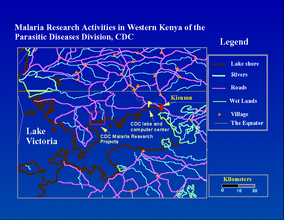 The
longitudinal study of the development of immunity to amalaria in young children was carried out
in a 70 square km area in Siaya district in western Kenya (8). Clinical, hematologic, parasitologic,
immunologic, entomologic, and demographic data were regularly collected for each participating
family in 15 villages. The entomologic data consisted of weekly trap collections for each study
households. Clinical data was collected biweekly. Blood samples were obtained monthly or
whenever any fever is reported. Blood samples were used to measure parasitemia, hemoglobin
levels, and on certain subsamples, immunologic parameters. Since all of these data were collected
with household identifiers, opportunities for examining spatial hypotheses exist in many disciplines
if a map of study households, health care centers, mosquito larval habitat, bodies of water (rivers,
lakes), roads, and other features of interest could be produced in a computer-readable format and
linked to the various study databases through GIS and other statistical software. Existing maps
and aerial photography were either unavailable, inaccurate or too outdated (9) to be useful for
mapping households and many of the other features of interest.
The
longitudinal study of the development of immunity to amalaria in young children was carried out
in a 70 square km area in Siaya district in western Kenya (8). Clinical, hematologic, parasitologic,
immunologic, entomologic, and demographic data were regularly collected for each participating
family in 15 villages. The entomologic data consisted of weekly trap collections for each study
households. Clinical data was collected biweekly. Blood samples were obtained monthly or
whenever any fever is reported. Blood samples were used to measure parasitemia, hemoglobin
levels, and on certain subsamples, immunologic parameters. Since all of these data were collected
with household identifiers, opportunities for examining spatial hypotheses exist in many disciplines
if a map of study households, health care centers, mosquito larval habitat, bodies of water (rivers,
lakes), roads, and other features of interest could be produced in a computer-readable format and
linked to the various study databases through GIS and other statistical software. Existing maps
and aerial photography were either unavailable, inaccurate or too outdated (9) to be useful for
mapping households and many of the other features of interest.
The second project, which includes the 15 villages in the Cohort project and over 60 more in
adjacent areas, has the goal of evaluating the effect that insecticide-impregnated bednets on
childhood mortality. This is a simple and inexpensive intervention. Bednets are soaked in an
odorless insecticide and draped over beds to keep mosquitoes out. The insecticide prevents the
mosquitoes from entering the net, even if there are small holes in the net. Because
malaria-transmitting mosquitoes feed only at night, sleeping under the nets should effectively
reduce illness and mortality due to this disease. Half of the villages in this project will receive
bednets, the other half will receive them in two years. Ultimately, this project will include 150
villages with a population of over 150,000. Since the Immunity study villages are also included
in this study, we will have detailed longitudinal data on a subset that will allow us to evaluate the
effects of using impregnated bednets on the development of a child's immune system, as well as
it's impact on mosquito populations in the study area.
This paper describes the differential global positioning system methodology used to produce a
map with highly accurate locational information for all of the geographic features of interest, and
follows the process through to the final output: spatial analysis.
Methods:
The Global Positioning System
Twenty-four satellites (21 for navigational purposes, 3 active reserves) orbiting at an altitude of
approximately 10,900 miles (20,200 km) form the the global positioning satellite network (10).
GPS satellites continuously broadcast the time, and their orbital path to provide the information
used by a terrestrial GPS unit to compute the longitude, latitutude, and altitude (also called a
position fix). Two types of signals are broadcast: one for worldwide civilian use, another for
military use. Generally, six or more satellites are "in view" at any place in the world 24 hours a
day. Data received from four satellites allows the GPS unit to calculate latitude, longitude, and
altitude, while data from three satellites allows calculation of latitude and longitude only. The
exact methodology for how position fixes are computed is described in detail elsewhere (11).
GPS errors:
The computations of a GPS position fix are subject to error from several uncontrolled factors:
clock errors, atmospheric conditions, GPS receiver noise, and reflectance of satellite signals (12).
The largest error component, selective availablity (SA), is the intentional error component added
for security purposes at each satellite. Because SA error varies with time and from one satellite to
the next, when a GPS unit changes the group of satellites it is using to compute a position fix, the
different SA error term results in a sudden change in the computed location. A single reading on
a standard GPS unit has "accuracies" of 100 m horizontal, and 156 m vertical (10).
Approximately 55 m of the horizontal error is due to SA (12). Accuracy is defined as two
standard deviations of measurement error. The carrier-phase position dilution of precision
(CDOP) is a measurement of the possible position error that is related to the geometric
configuration of the satellites used to compute a position fix (10,12). The CDOP is minimized
when three satellites are high and one is near the horizon. Accuracy is inversely proportional to
the CDOP.
Differential GPS:
Errors of 100 m for horizontal measurements (latititude and longitude) and 150 m for vertical
accuracy are far too large to make simple GPS use practical for mapping the locations of objects
that are relatively close together, such as households within villages. Such large errors will result
in gross distortion of the true spatial relationships between the measured points. Such spatial
inaccuracies would be make a map produced with simple GPS readings very confusing to use for
operational purposes.
Differential GPS circumvents the effects of SA and environmental errors to produce a highly
accurate position fix. Several different approaches to DGPS exist, but each employs the principle
of having two GPS units simultaneously taking readings from the same set of satellites. One GPS
unit is located at a fixed control site, preferably a known location, and the others become the
roving field units. As a result, the position fixes for both GPS units are subject to the same SA
and clock error terms. If the units are relatively near to each other (under 50 km), the precisely
timed GPS signals travel through similar ionospheric and tropospheric conditions (12). For both
units, each position fix is stored to a computer file, along with the exact time of the reading and
the set of satellites used to compute the location. The matching files for the two GPS units are
then downloaded to a computer. Software is used to pair or synchronize readings that were taken
at exactly the same time. Three methods exist for comparing the paired readings from the GPS
units: double-differenced pseudorange differential processing, carrier-phase processing, and
mobile-point processing. For each of these methods, the location of the remote GPS unit is
computed by adding the distance between the two GPS units to the known location of the control
GPS unit. In our application, this involved simultaneous creation of computer files on control and
remote GPS units, followed by copying these files to a computer and running software to
compute calibrated positions.
Carrier phase differential GPS takes the computed distances between a particular satellite and the
two GPS units (called pseudoranges), after discarding readings that do not match up with units
with respect to time and satellites. It utilizes the principle of the Doppler effect by utilizing the
velocity vector of the satellites used during the GPS session of obtaining position fixes.
Pseudorange differential processing only uses the precise location of each satellite during the data
collection session. GPS position and satellite velocity data are input into a weighted
least-squares model, which solves for the corrected position offset between the two units. This
method of computing location requires 7 to 10 minutes of data collected at a rate of one fix per
second (400 to 600 position fixes) to reduce errors to less than one meter in any direction (12).
Pseudorange differential positioning is less accurate 2-5 meters on the vertical scale, and 7-10
meters of error on altitude, but takes less time to collect and is perfectly adequate for many
purposes. We chose to use the more accurate carrier-phase positioning.
Linear features such as roads, streams, and lake shores are mapped using mobile point differential
positioning. As before, the GPS base station is used as a stationary control point, but here the
remote unit is moving during data collection. The antenna of the remote GPS unit was placed
outside of a moving vehicle to map roads. Rivers and streams were mapped by a person walking
by the bank, holding the "remote" GPS unit. To map the shore of Lake Victoria, a fishing boat
was chartered to be rowed near the shoreline, while field staff operated the GPS unit. As with
other differential techniques, the calculated control position was compared with the true control
position. The resulting correction factor was applied to each matched position over time. This
procedure did not have a measurable accuracy because the location of the remote GPS unit was
continually changing, preventing the calculation of the mean position and its standard deviation.
Differential GPS Applied to the Asembo Bay Malaria Cohort Study:
We established a GPS base station to serve as a control point near at the computer center in our
field station near Kisumu, Kenya. A collapsible 8 meter antenna was constructed to lift the
receiver above any obstacles that might block satellite signals. A cable connected the antenna to
the GPS unit, which in turn, was connected to the The exact location of the control GPS unit was
unknown, so thousands of readings were taken over several days and averaged to provide an
estimate of the true location. Because this position was used as a correction factor for all remote
sessions, any error associated with estimating the control location was consistent across all
remote points - having the effect of moving the entire map in one direction or another.
Equipment and personnel:
We are using four Magellan Pro Mark Xcp GPS units * (12). These units use the latest
"all-in-view" technology. The units record data from all available GPS satellites, unlike previous
generations which required manual selection satellites based on a software analysis of satellite
orbits. If the signals of one of more satellites were blocked by a building or tree cover, the remote
team would have to communicate with the control point GPS operator to choose alternative
satellites that were suitable to both. This process is now unnecessary, which has greatly sped up
operations. One unit is used for the permanent GPS base station, and the other three are field
units. Tripod antenna extensions (2.5 m) for each field GPS unit, battery powered hand held
radios, replacement batteries for the GPS units, and a list of compounds to be mapped round out
the equipment list for the field teams. Each field GPS unit uses six AA alkaline batteries per day
or two sets of shorter lived but more economical rechargeable alkaline batteries per day per unit.
Total equipment and software costs were approximately $20,000 for the GPS equipment and GIS
software. One person is needed for each of the three field GPS. Each field GPS team member is
met by a local village health worker who knows where to find the points to be mapped. Each
point to be mapped results in a 150 Kb file being created for later comparison with GPS data
collected at the base station at the same time and using the same satellites. A computer specialist,
working part-time on this project, was responsible for GPS to PC data communications at the
field station, using the DOS-based post-processing software to compute the calibrated positions,
and any data entry on a 486/66 computer.
*Use of trade names is for identification only and does not imply endorsement by the Public
Health Service or by the U.S. Department of Health and Human Services.
Approximately one hour of computer work was necessary to process six hours of GPS data -
generally between 6 and 8 megabytes of data representing roughly 100 positions. Approximately
six person months of effort have been used to date required for the field work, post-processing,
and data entry. Total costs of labor and supplies to map the bednet project area has not exceeded
$10,000.
Logistics:
A list of the identification numbers of the households or compounds to be visited is produced.
While the field team is driven to the day's work site, a staff member at the computer center
extends the antenna and begins continuous collection of GPS data at the base station. Each of the
three field GPS teams have a printout of the locations to be mapped that day, a GPS unit mounted
on a tripod, a compass, and a walkie-talkie. The field antennae are was set at a height of 2.5 m,
which is adjusted for by the post-processing software. When the remote teams set up the GPS
antenna, they note the distance and direction of the antenna's position from each point to be
mapped. In most cases, the antenna was placed 5 m in front of houses to be mapped.
Approximately 7.5 minutes of overlapping data from the same set of four satellites must be
recorded on both remote and GPS base station units. The walkie-talkie was used for routine
communications. Losing the signal of several satellites during a session can require the session
be repeated, so signal strength is checked during the session. Since optimal satellite geometry
calls for one of the satellites to be near the horizon, this loss of signal in a critical number or
satellites happened in approximately 5% of sessions. All sessions that had CDOP's >3.0 were
repeated.
At the end of the day, the field GPS units were returned to the computer center at the field
station, where their files were downloaded and GPS memories were cleared for the next day's use.
The base station's and remote GPS files for each point to be mapped were then matched and
analyzed using the post-processing software to compute a calibrated longitude, latitude, and
altitude. This information was entered into a database file, along with the ID number of the point,
an attribute descriptor (household, mosquito larval habitat, and so on) and a brief description, if
necessary.
Mobile sessions files were processed in a slightly different fashion. As with the point files, the
remote and control files were analyzed with the post-processing software. This resulted in a file
of corrected positions, which was imported into AutoCad (13), where the points were replaced
with a smoothed line, computed with a spline function. The AutoCad export file for the resulting
line was then converted to the proper format for the GIS software.
GIS Analysis:
Atlas GIS (14) and SAS (15) were used for all spatial analyses. Location information was linked
to parasitology and entomology databases through common identifiers. In the immunity project,
there were entomologic, immunologic, epidemiologic, meteorologic, demographic, and
parasitologic information that could be linked to each household.
Automated, or batch computing of distances between one group of points to another is a feature
that is not available in the popular entry-level GIS programs unless supplemental programming
tools are purchased. A SAS program has been developed that computes all possible distances
from one group of points to another, chooses the smallest distance from each point in the first
group to any point in the second group, and then creates an output database with household
identifiers and the desired distances. The second group of points may be a collection of points,
lines, or regions. The accuracy of the program has been checked by comparing its results with
distances computed interactively using the GIS software. The distance computations account for
the curvature of the earth by computing arc length instead of linear distance (16).
This distance is used as a basis for computing spatial statistics (i.e., the parasitemia rate for
households 0-200 m, 201-400 meters, and so on from the nearest mosquito breeding site) or can
be used in further statistical modeling. As a result, GIS software is not necessary for conducting
many spatial analyses, once positional information is obtained via GPS or some other source.
Quality assessment:
Maps of each of the 15 villages were produced and distributed to village monitors, who assessed
their accuracy and completeness. Special opportunities often arose for external validation. Many
households were near roads, so they were checked to verify that the map showed them on the
proper side of the road and at the correct approximate distance. Households or compounds that
were clustered were also checked for proper distances and relative geometric relationships.
Features of interest that had not been mapped were noted for later inclusion.
The performance of the GPS units and the post-processing software, as well as correct usage by
the operators, was checked by placing the two units next to each other, designating one as the
control unit, collecting positional information for 20 sessions of 5 minutes each, and computing
the calibrated location of the remote unit. The mean and standard deviations of the calibrated
longitudes, latitudes, and altitudes of the remote units were then computed.
Demonstration Data:
Entomologic and parasitilogic data were used to demonstrate simple GIS analyses. Entomology
and parasitemia data for months June, and September 1995 are presented to represent rainy and
dry seasons, respectively. Since households were enrolled when a pregnancy occurred and
eliminated if there were no eligible children, parasitemia and entomologic data are only available
for a fraction of the mapped households at any one point in time. We had parasitologic and
sufficient entomologic data (3 or more visits during the month) for 394 households in June and
416 households in September. For this analysis, potential larval habitat was defined as the
lakeshore, streams and rivers, and pits dug to collect water for cattle. Multiple linear regression,
correlation coefficients, and r-square statistics for each month were used to examine the
relationship between distance from major mosquito breeding sites and average numbers of trapped
mosquitoes by species for each month.
Results:
 The Bednet project (Figure 2) covers an area of 192
square kilometers over a rectangular area roughly 12 km long and 7 km wide, encompassing 75
villages. Geographic features include 7,209 compounds (each with a plot character to designate
its village), 65 schools, 1 nursery, 1 polytechnic school, 110 churches, 9 health care facilities, 1
rural AIDS counseling center, 70 major mosquito breeding sites, 10 borehole wells, 7 shopping
areas, major roads, streams, and the shore of Lake Victoria. In terms of distances, 42.0 km of
roads, 54.3 km of streams, and 15.0 km of lake shore were mapped. The altitudes of the 7209
compounds in the Bednet project are shown in Figure 3.
The Bednet project (Figure 2) covers an area of 192
square kilometers over a rectangular area roughly 12 km long and 7 km wide, encompassing 75
villages. Geographic features include 7,209 compounds (each with a plot character to designate
its village), 65 schools, 1 nursery, 1 polytechnic school, 110 churches, 9 health care facilities, 1
rural AIDS counseling center, 70 major mosquito breeding sites, 10 borehole wells, 7 shopping
areas, major roads, streams, and the shore of Lake Victoria. In terms of distances, 42.0 km of
roads, 54.3 km of streams, and 15.0 km of lake shore were mapped. The altitudes of the 7209
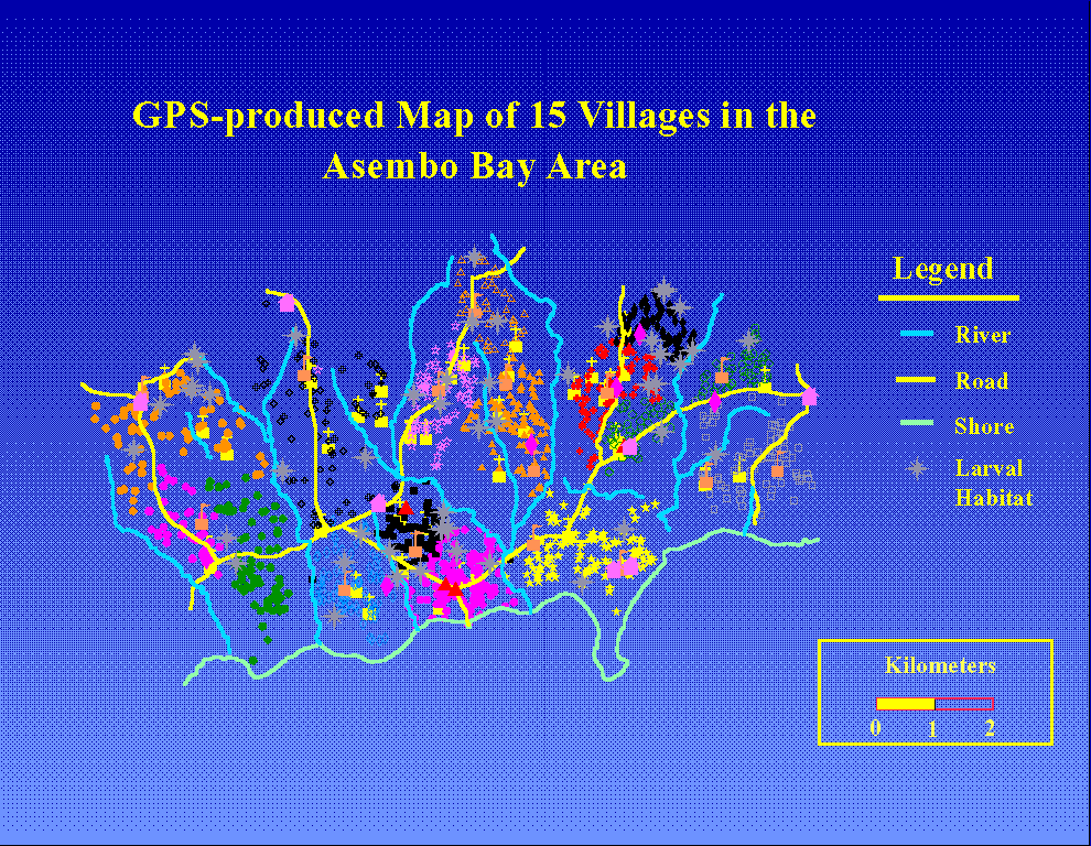
compounds in the Bednet project are shown in Figure 3. 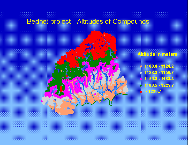 The Immunity project area (Figure 4) contains 15 villages in the
southeastern section of the Bednet project.
The Immunity project area (Figure 4) contains 15 villages in the
southeastern section of the Bednet project.
 Of the twenty sessions taken with the two GPS units stationed next to each other, one (5%) had
insufficient overlapping data to estimate a calibrated position. This is normally caused by the loss
of a satellite signal during a session,. Of the 19 remaining sessions, the longitudes had a standard
deviation of 4.01 m, the latitudes had a standard deviation of 5.34 m, and the altitudes had a
standard deviation of 4.78 m. The two dimensional standard deviation of these sessions was 3.11
m and the standard error of the mean was 0.714 m.
Of the twenty sessions taken with the two GPS units stationed next to each other, one (5%) had
insufficient overlapping data to estimate a calibrated position. This is normally caused by the loss
of a satellite signal during a session,. Of the 19 remaining sessions, the longitudes had a standard
deviation of 4.01 m, the latitudes had a standard deviation of 5.34 m, and the altitudes had a
standard deviation of 4.78 m. The two dimensional standard deviation of these sessions was 3.11
m and the standard error of the mean was 0.714 m.
Table 1.
Parasitemia Prevalence and Entomologic Measures by Household
and Distance to the Nearest Mosquito Larval Habitat, June and September 1995
| Distance to
nearest Larval
Habitat |
Parasitemia Rate
(%) in Children
<5yrs.
Month
June September |
Anopholes gambiae :
Avg. Number
trapped per
collection
Month
June September |
Anopholes funestus:
Avg. Number
trapped per
collection
Month
June September |
| 0 - 200
meters |
75.8+39.1
n=75 |
58.5+47.8
n=71 |
1.76+2.53
n=69 |
0.09+0.19
n=57 |
3.07+2.94
n=69 |
0.19+0.34
n=57 |
| 201- 400 m |
71.1+42.7
n=214 |
69.4+43.4
n=206 |
1.49+1.71
n=176 |
0.05+0.18
n=164 |
3.40+3.76
n=176 |
0.31+1.42
n=164 |
| 401-600 m |
70.2+43.1
n=117 |
64.7+45.3
n=109 |
1.90+2.31
n=113 |
0.03+0.10
n=108 |
4.17+5.58
n=113 |
0.20+0.37
n=108 |
| >600m |
67.1+46.3
n=39 |
57.8+47.7
n=30 |
2.09+2.05
n=37 |
0.02+0.06
n=33 |
4.70+7.80
n=37 |
0.34+0.53
n=33 |
| p-value* |
0.3437 |
0.5594 |
0.1530 |
0.0039 |
0.0191 |
0.6608 |
* Linear regression, two-tailed test. Percent of children in household with parasitemia or average
number of mosquitoes captured per weekly trapping session vs. minimum distance (in meters)
from household to nearest larval habitat.
Table 1 relates parasitemia prevalence and entomologic measures to the distance from the
household to the nearest major larval habitat. For the month of June 1995, a rainy month, the
average household prevalence of parasitemia in children less than 5 years old steadily decreased
with increasing household distance from larval habitat, but this difference was not statistically
significant (p=0.3437 linear regression ). There was no relationship between distance to larval
habitat and average parasitemia prevalence for the month of September, a dry month. Average
numbers of trapped mosquitoes were related to the distance of the household to the nearest
breeding site for An. gambiae for the dry month, but not the wet month (September: p=0.0039;
June:p=0.1530, linear regression). In contrast, average numbers of An. funestus appeared
increase with increasing distance from larval habitat during the rainy month, but had no
relationship to distance to major larval habitat during the dry month (June : p=0.0191, September:
p=0.6608, linear regression).
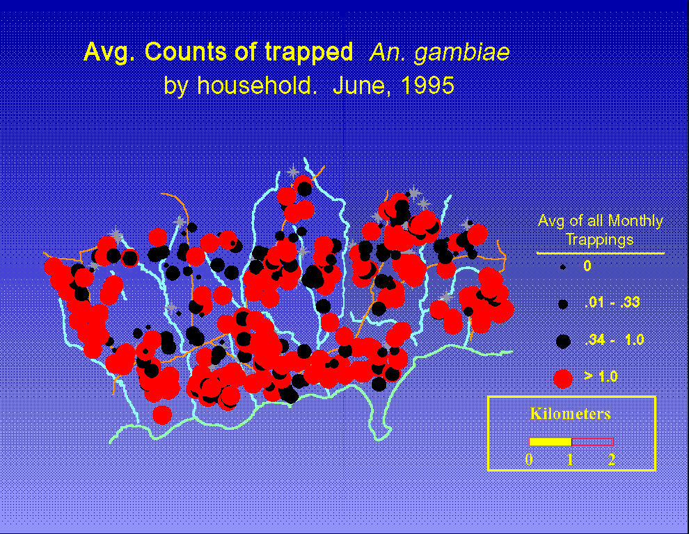
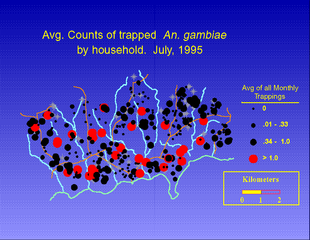
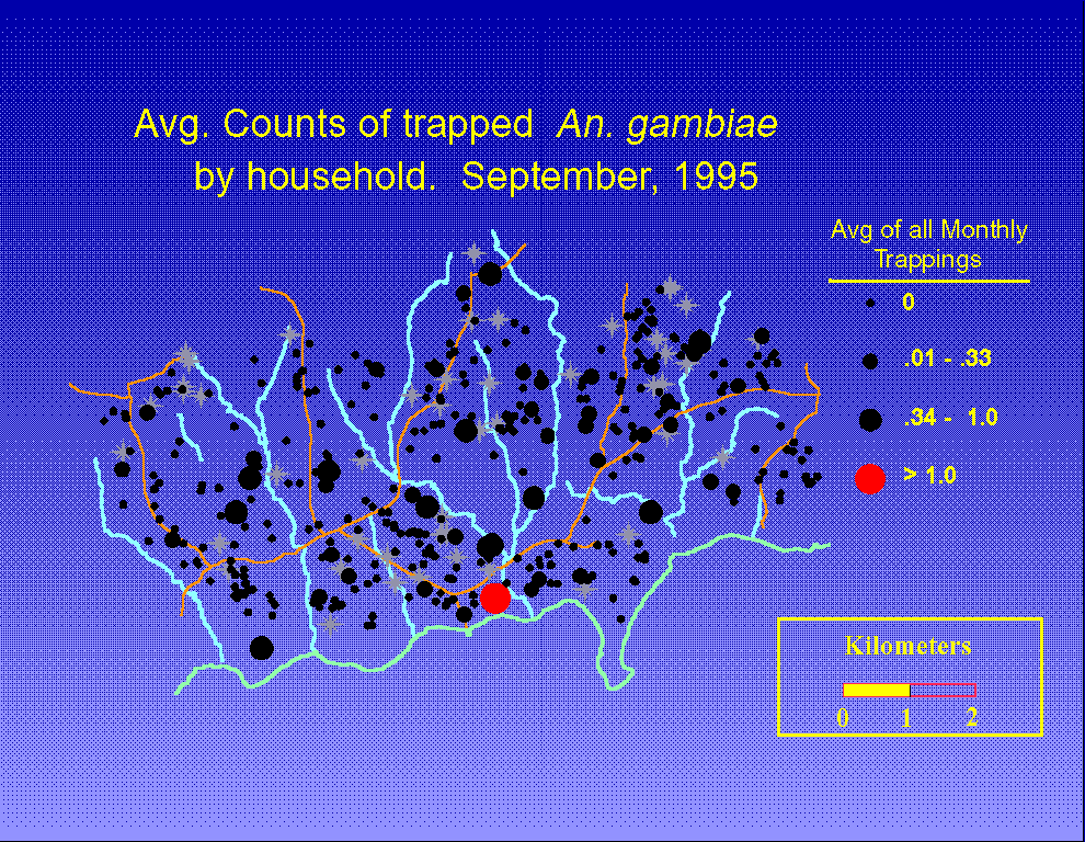
Figures 5 through 7 show the average number of trapped An. gambiae by household for the
months of June, July, and September 1995. Mosquito prevalence drops off rapidly after June
Villages vary significantly in the numbers of mosquitoes trapped by household (all months,
p<0.01, one way ANOVA). However, there is considerable variation both among and within
villages. Anopheles funestus also displayed significant variation by village (all months, p<0.001,
one way ANOVA, data not shown). The spatial pattern exhibited by An. gambiae was quite
different than that of An. funestus. Variation in one species explains only 29.6% of the variation
in the other during June and 7.8% in September (r-square, simple linear regressions).
 Discussion:
We have shown that it is feasible to use differential GPS to produce a highly accurate map of
study households and other points of interest in a large scale study of malaria in an area
encompassing more than 75 villages over 190 square km. Without differential GPS, positional
errors are such that any mapping of objects within 200 m or so of each other will yield
inconsistent spatial relationships between map features, since the errors associated with use of
nondifferential GPS can be on the scale of 100 m. Use of simple GPS readings is appropriate
when the objects to be mapped, such as villages, are relatively far apart (7). Additionally, we
have shown that it is easy to map linear features such as roads, rivers, and lake shores. The
comprehensive maps have considerable use in the operational activities of the project and GIS
allows the maps to be produced to customized needs in a rapid manner.
The magnitude of expense and effort to create this GIS were small relative to the other costs of
this project, with expenses being approximately $30,000. Of this amount, approximately $20,000
was for hardware and software which continues to be used on new projects conducted in this
area. However, researchers doing one-time, short-term or small-scale studies may decide that the
financial and time investment to be not worthwhile for their particular projects. The time needed
to master differential GPS equipment would seem to make rental of equipment not worthwhile to
the novice.
Our efforts at quality assessment raise several points. First, the results from the twenty sessions
with the GPS units adjacent to each other demonstrate the greatly increased precision associated
with differential GPS. A previous study (6) reported a standard error of 47 m associated with
repeat measurements at 43 randomly selected households with an average discrepancy of 36 m
from the original measurement. A 95% confidence interval on the average discrepancy is over 90
m wide which is in agreement with the stated error associated with crude GPS readings. Using
pseudorange differential GPS, the standard error (variability of the mean of a group of 19
measurements) was 0.714 m, or a standard deviation of 3.11 m (reflecting the variability in the
calibrated readings). Thus, DGPS greatly reduces the errors and variability in positional
measurements associated with mapping. This allows mapping of features that are close together
in a manner that will maintain spatial relationships with a high degree of integrity.
Training field staff to perform the necessary duties for DGPS mapping presented no difficulties.
Because existing staff were employed for the mapping operations on a part-time basis, the new
duties were a novelty, and the opportunity to use recent aerospace technology to produce a map
of the study area was exciting to all involved. Moreover, recent improvements in GPS technology
have greatly simplified mapping operations. Newer GPS units employ all-in-view satellite
technology, which records data from all GPS satellites in the sky versus only four satellites used
previously. By connecting a GPS unit in a clear base location to a computer, field workers are
guaranteed that any satellites that they use will also be recieved by the base location GPS. This
eliminates the need for walkie-talkie communications, which greatly speeds up data collection.
Other improvements include faster GPS-to-PC communications, and the ability to obtain
sub-meter accuracy with data collection sessions of less than 10 minutes. The net effect is to
make the use of differential GPS a much simpler process than just two years ago.
The analyses presented here were intentionally simple and were intended to present only some of
the potential uses of the GIS/GPS data. Analyses did not account for a tremendous amount of
available data such as daily rainfall, altitude of the household, age of the child, immunologic
measures, longitudinal effects, previous infection history, or many other factors. However, the
entomologic analyses raised several points. First, there is considerable variation both within and
between villages for both mosquito species. Therefore, it is unlikely that a study that samples
only a few households will adequately represent the entomologic experience of a given village.
Second, we observed distinct patterns of abundance by household and village for each mosquito
species that change between rainy and dry seasons.
We have shown that GIS software need not be mastered to conduct many useful spatial analyses
once locational information has been obtained. Indeed, the spatial capabilities of the most popular
entry level GIS programs are quite limited, and the automated computations of distances require
supplementary programming efforts (18). Fortunately, this can be easily done in a statistical
program such as SAS or SPSS. Our example used distance from the household to the nearest
major potential larval habitat. However, many other distance variables, such as distance to the
nearest health clinic or medicine store, could just as easily be computed and additionally
incorporated into a statistical analysis. The basic maps and spatial analyses produced by
entry-level GIS programs are quite useful and might well satisfy a researchers' needs.
The analytic phase of this project has now begun in earnest by linking the base map produced by
the methods described here to various longitudinal data sets. Researchers will now have the
option of investigating the spatial aspects of any topic they are pursuing. Only time will tell as to
the relevance of spatial issues in the many varied areas of malaria research. However, we do
know for certain that we now have the practical ability to investigate these spatial issues as we
never could before.
Acknowledgements: The authors would like to acknowledge the contributions of Jacquelyn
Roberts for her help in digitizing the lake shore; Joseph Omolo and Christopher Lwoba for their
computer support; and Daniel Colley, for his support during the time it took to master, transfer,
and apply this new technology.
Authors' Addresses: Allen Hightower, Altaf Lal: Division of Parasitic Diseases, National Center
for Infectious Diseases, National Centers for Disease Control and Prevention, Atlanta, Georgia
MS F22, 4770 Buford Highway, Chamblee GA 30341 ;
William A. Hawley - American Embassy/CDC, UNIT 64100, Box 421, APO AE 09831;
Maurice Ombok, Richard Otieno, Aggrey J. Oloo, Bernard L. Nahlen:
Kenya Medical Research Institute, Vector Biology and Research Centre, PO Box 1578, Kisumu,
Kenya
E-mail address: Allen Hightower: awh1@cdc.gov
References
1. Beck LR, Rodrigues MH, Dister SW, Rodriguez AD, Rejmankova E, Ulloa A, Mesa RA,
Roberts DR, Paris JF, Spanner MA, Washino RK, Hacker C, Legters L. 1994. Remote sensing as
a landscape epidemiologic tool to identify villages at high risk for malaria transmission. Am J
Tropical Medicine Hyg; 51:271-280.
2. Clarke KC, Osleeb JR, Sherry JM, Meert JP, Larsson RW, 1991. The use of remote sensing
and geographic information systems in UNICEF's dracunculiasis (Guinea Worm) eradication
effort. Preventive Vetenary Medicine, 11:229-35.
3. Ahearn SC, De Rooy C. Monitoring the effects of dracunculiasis remediation for agricultural
productivity using satellite data. International Journal of Remote Sensing. In press.
4. Malhotra MS, Srivastava A. Diagnostic features of malaria transmission in Nadiad using
remote sensing and GIS, 1996. International Development Research Centre.
Source:URL:http://www/idrc.ca/books/focus/766/malhot.html
5. Gunawardena DM, Muthuwattac Lal, Weerasingha S, Rajakaruna J, Kumara UW, Senanayaka
T, Kotta PK, Wickremasinghe AR, Carter R, Mendis KN, 1996. Spatial analysis of malaria risk in
an endemic region of Sri Lanka. International Development Research Centre. Source:
URL:http://www/idrc.ca/books/focus/766/gunawar.html
6. Snow RW, Armstrong Schellenberg RM, Peshu N, Forster D, Newton CRJC, Winstanley PA,
Mwangi I, Waruiru C, Warn PA, Newbold C, Marsh K. 1993. Periodicity and space-time
clustering of severe childhood malaria on the coast of Kenya. Trans Roy Soc Trop Med Hyg
87:386-390.
7. Richards FO, 1993. Use of geographic information systems in control programs for
onchocerciasis in Guatemala. Bull Pan Am Health Organ 27:52-5.
8. Shi YP, Sayed U, Qari SH, Roberts JR, Udhayakumar V, Oloo AJ, Hawley WA, Kaslow DC,
Nahlen BL, Lal AA, 1996. Plasmodium falciparum MSP-1: variation in the C-terminal region
from field-derived isolates and antigenic cross reactivity of the variant determinants. Infect
Immun 64:2716-2723.
9. Survey of Kenya, 1970. Series Y731 (DOS 423). Sheet 115/2. Edition 5-DOS, 1970. Nairobi,
Kenya.
10. United States Coast Guard Navigational Information. GPS: General information and facts
and figures. URL:http://www.navcen.uscg.mil/gps/gps.htm
11. Herring TA, 1996. The Global Positioning System. Scientific American, February 1996,
44-50.
12. User Guide for the Magellan GPS ProMARK X-CP, 1995. Magellan Systems Corporation.
San Dimas, California.
13. AutoCAD version 12. Autodesk, Inc. San Rafael, CA. 1992.
14. Atlas GIS, Version 2.1 (DOS) Reference Manual. Environmental Systems Research Institute,
Inc. Redlands CA. 1991.
15. SAS Institute Inc., SAS/STAT Users Guide, Version 6, Fourth Edition, Volume 2, Cary
NC:SAS Institute Inc., 1989.
16. USGS Professional Paper 1395 - Map Projections - A working manual. Page 30, formula
5-3a.
17. Digital chart of the world fact sheet. The Defense Mapping Agency of the United States.
URL:http://www.dma.gov/information/facts/
18. Kitron U, Pener H, Costin C, Orshan L, Greenberg Z, Shalom U. 1994. Geographic
information system in malaria surveillance: mosquito breeding and imported cases in Israel, 1992.
Am J Trop Med Hyg; 50:550-556.