Facilitating the Exchange of GIS Data and Analyses Within the Forest Management Program of the Naval Facilities Engineering Command, Southern Division
Abstract
The Southern Division Naval Facilities Engineering Command is currently implementing a GIS to assist in the management of forest and related natural resources for 21 Naval bases or facilities in the southern region. This GIS, named the Forest Management Information System (FMIS), consists of ArcView and personal Oracle components installed on an NT workstation at the Natural Resources Division of the Southern Division Naval Facilities Engineering Command. FMIS allows foresters at Southern Division to view forest resources on a base in the context of all related features that may impact forest practices, thus enabling them to rapidly make more knowledgeable management decisions and provide better management data to base foresters. Currently, the Southern Division provides this information and analyses via paper reports to the base foresters. In turn, base foresters supply compartment, stand, and forest practice data to the Southern Division for input into FMIS, also via paper reports and forms. Workflow for data input into FMIS involves ArcInfo and ArcView. Solutions to facilitate the exchange of data between the Southern Division and base foresters and to provide base foresters GIS capabilities for day-to-day management of forest resources are being investigated. These solutions are focused on stand alone MapObjects applications for base foresters and/or secure internet applications with MapObjects Internet Map Server. This paper will discuss pilot projects implementing these solutions and technical and organizational issues related to their implementation.
Introduction
In 1995, the Natural Resources Division of the Naval Facilities Engineering Command, Southern Division (SOUTHDIV NAVFAC) in Charleston, SC identified a need for improved tools with which to manage the forests and related natural resources on 200,000 acres of Naval land throughout the southern region of the U.S. GEOTEC, the Geospatial Technical Evalutation Center located at the Naval Command, Control and Ocean Surveillance, In Service Engineering Center, East (NISE East), was contracted by SOUTHDIV NAVFAC to develop a GIS that would both meet these immediate needs and provided a firm architecture for future growth and integration. This GIS, known as the Forest Management Information System (FMIS), has enabled the Natural Resources Division to develop the needed GIS capability with an open architecture from which they can both share and provide spatial data internal and external to SOUTHDIV NAVFAC.
FMIS
GEOTEC and the Applied Technology Division of Eagan McAllister Associates, Inc. developed a short and long term plan for FMIS that initially emphasizes data collection followed by distribution of GIS data. This focus has enabled the project to capitalize on the functionality of the entire Esri "tool set" from traditional ArcInfo through newer tools such as MapObjects and MapObjects Internet Map Server. During the data collection phase, spatial and attribute data for forest and related features is collected and processed with ArcInfo to build coverages in State Plane projections. Attribute tables are built according to Tri-Service standards. This data is converted to shape files and loaded into ArcView residing on an NT workstation. Existing data on forest management was loaded into an Oracle data base. Customized screens for data entry, data editing and report generation were generated. The forest management data loaded in Oracle was related to forest features within ArcView. Finally ArcView was customized to enable easy use of the system by the foresters on a day-to-day basis. During development of the system, coordination was maintained with other divisions within SOUTHDIV NAVFAC who had the potential to use themes developed in the course of the project or supply additional themes to the Natural Resources Divison. This coordination, the use of Oracle as a standard data base and the extensive intranet existing within SOUTHDIV NAVFAC provides for distribution and use of spatial data throughout the organization when desired.
FMIS Benefits
Although still under development, FMIS has greatly improved the ability of the Natural Resources Division to use the existing data. FMIS is used by the Natural Resources Division to develop and track the Forestry Master Plan for Naval facilities throughout the southern US. This 5 year plan is developed in cooperation with the base foresters to implement the best forest management practices for their facilities in accordance with Federal guidelines, funding considerations and other factors which influence the general welfare of the entire Naval forestry program. In addition, SOUTHDIV NAVFAC will use FMIS to help base foresters evaluate the overall effectiveness of the Forestry Master Plan and track progress of the facilities in implementing recommended practices. Previously, the plan had been developed without the aid of GIS. FMIS now allows foresters to view forest resources in the context of related features that may impact forest practices, thus enabling them to make more rapid and knowledgeable management decisions.
Future Goals
Due to the success of FMIS, it became apparent that there was a need for access to the forest management GIS data for other potential users within and external to SOUTHDIV NAVFAC. A review of potential users and their associated requirements revealed that not all users would require the full GIS analytical capabilities of the baseline FMIS ArcView application. It was decided to explore the use of MapObjects as a cost effective means to deliver GIS capabilities to other users. It was also recognized that the development of a MapObjects based application would facilitate the implementation of internet delivery of GIS data if that alternative was desired. EMA chose Visual Basic development environment for MapObjects based on its wide support and ease of use.
MapObjects Prototypes
Initial prototyping of MapObjects applications focused on requirements of base foresters and other personnel at Naval facilities associated with foresters at SOUTHDIV NAVFAC. Base foresters require GIS capabilities for day-to-day management of forest resources. Specific requirements identified for base foresters were the ability to create unique value maps of various forest stand characteristics and recommended practices, search and display acreage values of forest stand attributes, view and query forest stands in relation to other natural resources on the Naval facility, and compartment queries. These capabilities are incorporated in the application shown in Figure 1.
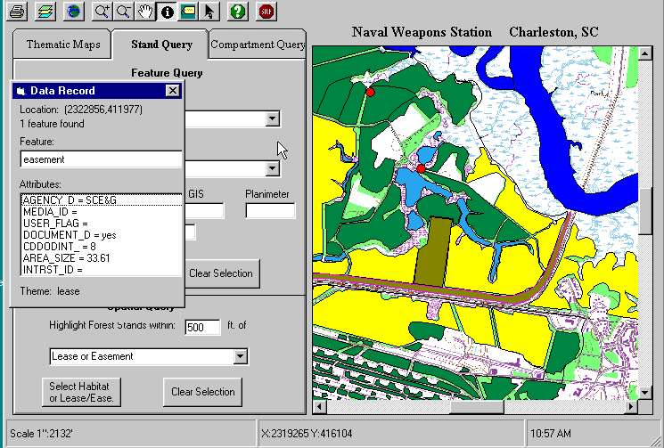
Figure 1. Initial prototype of MapObjects application for FMIS.
Another area in which the use of MapObjects is being investigated is to assist in transferring and communicating data concerning the status of forest resources and practices on a facility between base foresters and SOUTHDIV NAVFAC. This involves editing database and/or spatial data in a stand alone MapObjects application and transferring the files between SOUTHDIV NAVFAC and an individual facility. Specific requirements include editing forest stand attributes and practices and editing the shape files of forest stands and compartments. We have found these operations to be more difficult to implement in MapObjects and are currently still working on these applications. Additions to the object model in MapObjects 1.1 may help in implementing these capabilities.
Internet Plans
In addition to stand alone desktop applications, there is much interest within SOUTHDIV NAVFAC in exploring the exchange of data through intranet and/or secure internet applications. Traditionally the exchange of data between base foresters and SOUTHDIV NAVFAC has taken place in the form of annual summary reports and other paper documents. The feasibility in using intranet/internet exchange for these purposes is currently being evaluated. Concerns over security, infrastructure within facilities necessary to support these transactions and other factors are being considered.
Kate Ozalas, Bob O'Connell, Roger Tulk
Eagan McAllister Associates, Inc., Applied Technology Division
2050 Mabeline Rd. Suite J
Charleston, SC 29407
Telephone: (803) 553-4353