
The Sultanate of Oman's national Ministry of Housing has initiated the development of an ArcInfo-based GIS for its basemap and land records management. A GIS prototype has been completed to examine data conversion and application development options. The prototype had three primary tasks: develop a basemap, develop a land records database, and develop an initial ArcInfo user interface.
The digital basemap was compiled from four primary sources, each in a different file format.
The assembly of basemap digital files also required the transformation of data from an old coordinate system to a new coordinate system.
Task two was to develop a land records database based on attributes found on existing hard copy parcel records. Attributes were entered in Excel spreadsheets and then saved as ASCII files. The files were then uploaded into INFO tables. The land records database that was developed was designed to emulate a portion of the Ministry's existing Oracle tables. Eventually, the Ministry may link its Oracle database to the new ArcInfo system maintained by the Ministry.
The third prototype task was the development of an end-user application to demonstrate ArcInfo functionality of basemap and land records maintenance. The graphical user interface includes applications to perform data entry, transformation, QC, query and output. There is also functionality to translate digital files between ArcInfo and AutoCAD.
The paper will present some of the technical, institutional and
cultural challenges faced in developing an ArcInfo GIS prototype
in a quickly developing country.
The Sultanate of Oman's national Ministry of Housing has initiated the development of an ArcInfo-based GIS for its basemap and land records management. As part of a major GIS planning and implementation project, a prototype was completed to examine data conversion and application development options. The prototype had three primary tasks: develop a digital basemap, develop a land records database, and develop an initial ArcInfo user interface.
The Sultanate of Oman is an independent country located on the eastern edge of the Arabian peninsula. Its land area is approximately 81,000 square miles, there are approximately 2 million citizens and its government is lead by his majesty, Sultan Qaboos bin Said. Upon his ascent to power in 1970, the Sultan began a modernization program to capitalize on the country's developed, but limited, oil reserves. Modernization included the building of new roads, schools and hospitals, and also, a land granting program for Omani citizens. Any Omani citizen who wants a parcel of land may receive a land grant from the government. The land surveying and subdivision associated with the land grant program has created a significant workload for the government surveying and planning departments, both of which are located within the national Ministry of Housing (MOH).
Figure 1 shows the location of Oman and surrounding countries in the Middle East.
Figure 1
GIS hardware and software was purchased to assist the Ministry in its land records maintenance efforts. Hardware is based on a Silicon Graphics server and three X-terminals running Irix 4.1. Installed software is ArcInfo version 7.0.3. There are also several Pentium PCs running Windows 95, AutoCAD 14, and MS Office applications.
The first major task of the prototype was the development of a sample digital basemap, including planimetric and cadastral features. The digital basemap was compiled from existing AutoCAD and ArcInfo files, along with ASCII file input of parcel coordinates. The assembly of basemap digital files also required coordinate system transformation from the Clarke1880 spheroid to the WGS84 spheroid. For the GIS prototype, there were four primary sources of data for the digital basemap. Each source was in a different file format and a different coordinate system.
Of the four basemap data sources, only the AutoCAD files were already in the WGS84 coordinate system. The other three data sources were TRANSFORMED from Clarke1880 to WGS84 prior to inclusion in the digital basemap.
The prototype area consists of 8 tiles in the western portion of the Muscat capital district. Each tile is 1000 by 2000 meters so the prototype area totals approximately 16 square kilometers.
Five control points with coordinates in WGS84 and Clarke1880 projections were used to register prototype data. The control points were all located on one tile in the southern portion of the prototype area. If a larger prototype area were chosen, then more control points would have been necessary. Early in the prototype, the transform arguments were tested to determine if the data shift from Clarke1880 to WGS84 was accurate.
The National Survey Authority of Oman (NSA) has created a nationwide planimetric data layer in AutoCAD format. This is tile-based data in UTM coordinates with a WGS84 projection. The mapping is based on 1:20,000 scale aerial photography and the scale is as large as 1:2,000 in urban areas. The mapping accuracy is +/- .5 meters. For the prototype, ten tiles were translated from DXF format into ArcInfo coverages. The planimetric base features include pavement edges, building footprints, hydrography, topography and utility infrastructure points.
From a previous planning study, there were two ArcInfo coverages containing parcel outlines that cover a portion of the prototype area. One of the coverages had to be CLEANED to create contain polygon topology, and both coverages were TRANSFORMED from Clarke1880 to WGS84 coordinates.
The Ministry of Housing has an archive of planning area maps printed on mylar that depict planimetric, topographic and cadastral features from the mid-1970's. The maps were originally drafted onto a Clarke1880 grid. For the prototype, two of these maps were scanned and registered to WGS84 coordinates to use as a reference beneath the new digital layers. An image catalog was also created to simplify image display.
A new ArcInfo coverage was created from surveyed parcel coordinates. The Ministry's land record documents (Krookies) contain the X and Y coordinates for each parcel corner. From the Krookies, X and Y coordinates were entered into Microsoft Excel tables and then saved as ASCII files. The ASCII files were then used to GENERATE an ArcInfo polygon coverage. Since the surveyed coordinates on the Krookies were in Clarke1880 projection, the new parcel coverage was TRANSFORMED into WGS84 coordinates to match the rest of the digital basemap.
There was good success in overlaying the four data sources for the digital basemap. One potential source of error came in the interpretation of the NSA aerial photography. For example, pavement edge delineation is difficult in areas where asphalt, sand and gravel roads converge. This is common in the rapidly growing Muscat municipality. Consequently, there were some inaccuracies in the NSA AutoCAD planimetric base. Another source of error is that the scanned images were based on 20-year-old mylar drawings and the mylar had stretched during that time. Finally, there may have been errors made in manually transcribing survey coordinates from the Krookies to the Excel spreadsheets. Given these sources of error, there were not significant discrepancies when the basemap data was overlayed. In some cases, building footprints are shown extending beyond parcel boundaries. This may be the result of small scale data displayed at a large scale, or the parcel boundaries may have been transferred incorrectly from the Krookies. In other instances, the polygons created from the Krookie-based ASCII file overlay precisely with the parcel outlines scanned from the 20-year-old planning area maps.
For the purposes of demonstrating the different data sources that can be entered into a GIS, the basemap compilation was considered a success.
Figure 2 shows an overlay of the scanned planning area map in
white, the new parcel coverage in blue and the AutoCAD-derived
planimetric coverage in red.
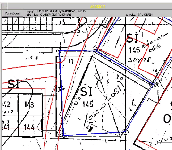 Figure 2
Task two of the prototype was to develop a land records database based on attributes found on existing hard copy parcel records. The Ministry maintains Oracle tables to help track information on approximately 250,000 legal plots. It was determined that for the prototype, it was not feasible to link ArcInfo to the Oracle database. First, the Oracle tables are in Arabic and second, the tables are not organized around a common field that could be used to relate to the ArcInfo parcel coverage. Instead, the focus was on demonstrating the functionality of ArcInfo to allow development and update of non-graphical land records attribute tables. To that end, a new INFO file was DEFINED to emulate key components of the existing Oracle tables.
The MOH is responsible for maintaining individual records of all privately-held property. The standard land record is a mylar document called a Krookie. A Krookie contains surveyed coordinates, a site plan and basic cadastral attributes such as section, block and lot numbers. There are also attributes related to built features including building height, number of floors, available parking and percent of building coverage over the entire parcel.
Parcel attribute information was extracted from Krookie land records sheets and then entered into Excel spreadsheets. Attributes include the parcel ID number, land use, building height, existing parking, and village name. The Excel files were saved in ASCII format and then ADDED to the new INFO file, landuse.dat. A relate was saved between landuse.dat and the new parcel coverage to emulate a future link between ArcInfo and an external Oracle database. A second INFO file, coord.dat, was DEFINED to store coordinate information for each parcel corner. Items include the parcel ID number, X and Y coordinates in both WGS84 and Clarke1880 projections, the point number from the Krookie drawing, and the segment length of the side of the parcel. For the prototype, approximately 100 land records were added to the two new INFO files. Since the INFO files were RELATED to the newly-generated parcel coverage, there was a one to one match between the INFO file records and records in newparcel.pat. For the purposes of demonstrating that a parcel polygon record could be linked to a corresponding record in a separate database, this task was considered a success.
Figures 3 and 4 present examples from landuse.dat and coord.dat.
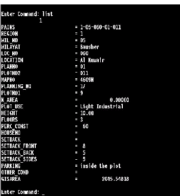 Figure 3: landuse.dat
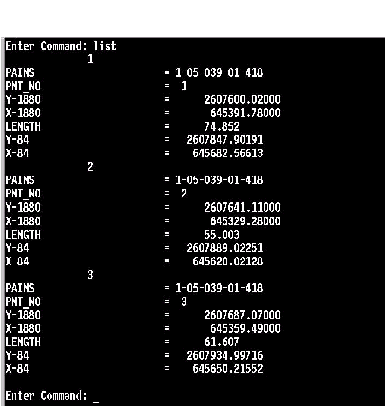 Figure 4: coord. dat
The third prototype task was the development of end-user applications to demonstrate ArcInfo functionality of basemap and land records maintenance. Throughout the prototype period, AMLs were written to facilitate data translation, data conversion, hard copy output, and to demonstrate other GIS functions. These AMLs were eventually integrated into a series of menus to demonstrate an ArcInfo end-user application.
Figure 5 illustrates the prototype demo menu that integrates several applications.
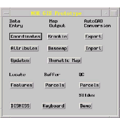 Figure 5
The data translation and conversion AMLs were used intensively for the assembly of the digital basemap. Each ASCII file containing parcel coordinates and parcel attributes was processed by these AMLs so that newly-generated data would be developed consistently.
Of the AMLs written to generate hard copy output, the most important was the routine that created a GIS-derived Krookie. The Krookie is the Ministry's most widely used land record document so it was imperative that the prototype demonstrate the ability of ArcInfo to store graphical and tabular cadastral information, and then retrieve and plot this information easily. Significant time was spent in designing ARCPLOT routines to emulate the look and content of the Ministry's Krookies.
Figure 6 is an example of a GIS-generated Krookie.
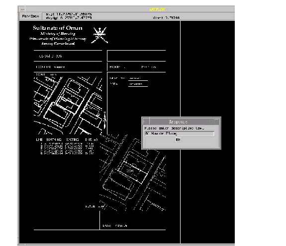 Figure 6
The fourth group of AMLs were developed to demonstrate typical GIS functions that MOH staff might use when their system is fully operational. One example is to query the database to locate a parcel based on a parcel ID number. Another query was developed to find a parcel based on prominent landmarks. In Oman, there in no system of street addresses, so highway navigation is instead based on landmarks. For the prototype, a point coverage of landmarks was developed to support this query.
Figures 7 and 8 provide examples of the locate functions.
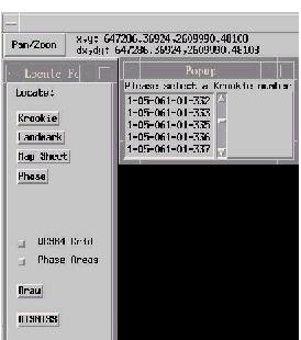 Figure 7
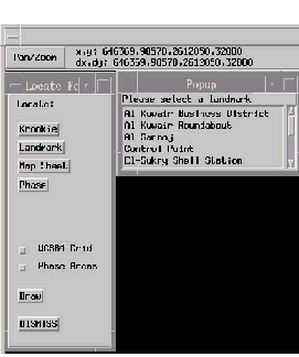 Figure 8
Other GIS functions that were demonstrated included road centerline
buffering and comparisons of parcel areas calculated by ArcInfo
versus the parcel areas as entered from Krookie attributes. This
comparison function was used as a quality control step to check
the integrity of the new parcel coverage and INFO files.
Another group of AMLs were written to facilitate the translation of digital files between ArcInfo and AutoCAD. At this time, MOH planners are using AutoCAD for their subdivision design tasks, so it was important to demonstrate a digital file translation function. The application that was developed allows MOH staff to specify a section of the database that they would like to extract. From the user-defined box, portions of two ArcInfo coverages are CLIPPED and placed into a new coverage that is translated to DXF format. The coverages that are extracted contain the new parcel polygons and the planimetric basemap features. As the ArcInfo coverages are CLIPPED, all related parcel attribute records in landuse.dat are dumped into a dBASE file. The net result is that MOH staff can continue to use AutoCAD and dBASE files in a method with which they are familiar. Once the extracted data has been updated, the application allows for the translation of the DXF and dBASE files back into ArcInfo.
The GIS prototype for the Ministry of Housing achieved the three goals of developing a digital basemap, developing a land records database, and developing an initial ArcInfo user interface. The functionality built into the user menus and AMLs is operational and has allowed MOH staff to perform additional data input and query. At this time, the Ministry must decide on a method to convert its thousands of cadastral records into an ArcInfo format. For the prototype, it was feasible to enter X and Y coordinates for several dozen parcels. However, this may not be the best option for several hundred thousand parcels. Other alternatives include scanning and vectorization, or board digitizing.
Another data conversion issue that must be addressed is the migration of the Ministry's Oracle database to a more standardized relational database format. At this time, there is considerable redundancy between the tables, and there is no standard relate item to the GIS data. Another issue is that all the tables are in Arabic only. ArcInfo has an Arab language translator, but all of the GIS work has been in English up to this point. A decision will need to be made about standardizing tables and applications in one language.
PlanGraphics has completed the first phase of the Ministry of Housing's GIS project, which culminated in the presentation of a comprehensive GIS implementation plan and budget. Regarding the next steps in this project, the Ministry has plans to tender additional contracts for cadastral data conversion and application development tasks. However, the timing for these phases is not decided. This is partly because the cost of converting the Ministry's land records will be very high, regardless of the conversion method.
I would like to thank the following three individuals for their invaluable guidance, support and friendship throughout the prototype project:
Larry Raper, PlanGraphics project manager in charge of the Ministry of Housing GIS Implementation Project.
Khalid Al-Nabhani, MOH Information Systems Manager.
Abdulla Al-Mazrooi, MOH Surveying Engineer.
Also thanks to Arthur, Aza, Aisha, Gharniga, and Anaat.
Bill Press
Systems Analyst
PlanGraphics, Inc.
1300 Spring Street, Suite 306
Silver Spring, MD 20910
(301) 588-8535 voice
(301) 588-5979 fax
bpress@plangraphics.com