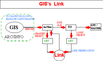
OT consists of two products: the application for end user and a librarian of several control (VBX/OCX) who allows you to link one or more 0T to the ArcInfo (ArcView) ID.
The features includes the possibility of divide, join, group and explode the geographical objects and their Information maintaining the Historical trace of evolution.
Each object can inherit (subject to the control) the information (link and attribute) of the previous OT.
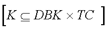
The application can join GIS, Anagraphical, Historical, Cadrastal information and each other database in the system.
The applications was written using: GUPTA
SQL Windows, C + +, AVENUE, Visual
Basic.
Because of the specific issues related to map displaying and because of the meaning related to territorial objects and legal issues, a public agency's GIS is very complex.
Cartography management in a public agencies is subject to a series of organizational limits : by no means a single operator may modify a map object whatsoever.
Each modification is and must be subject to a strict formal and
legal control : cartography must be audited to be a legal
tender.
Each modification should be a single step in a sort of work flow suited to the public agency's needs.
The rules should be clear. The usage of such a work flow allows a remote user connected via a client station, after a series of security ID procedures, to access the GIS tailored to suit his or her specific needs : available maps, views, themes would only be those he or she are allowed to access and so would be the available editing tools.
In any Public agency the editing of map sheets is proceeded by a legal or technical organizational phase.
We have identified the basic concepts of territorial management
that offer homogeneous working modes and that allow standardization
of management software, whatever the territorial element shall
be.
We should watch at territory with a new attention, spot the smallest relations among territorial objects and their most intimate meanings. SIT (GIS + Municipal Environment) data bases are always more complex and obviously final user cannot build them nor can they manipulate them.
The average complexity of a SIT is identifiable in about 500 - 1000 relational tables, and the final User does not know how to organize a select from many related tables.
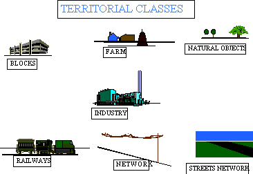
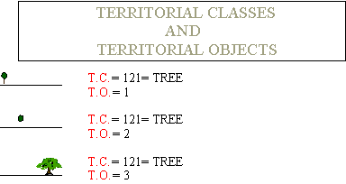
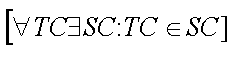
Each Territorial Element is displayable through a simple chart that gather homogenous elements in Territorial Objects identified by a unique ID number.
Each Territorial Objects is an element of a class
that gathers homogeneous elements called Territorial Class.
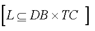
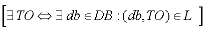
In a SIT the Territorial Objects is a natural link to information and helps organizing data. The Territorial Objects is more time resistant that informative entities it is related to : people addresses, law, cadrastal ID, rules, etc. .
Each object owns fundamental links and features typically related to each Software applications, which are relative to each logical view of the object.
A friendly SIT not only allows simple data input but also
simple search procedures. If we want to build such a SIT
we should imagine a flat and homogeneous structure for each territorial
element and define a few, clear, simple and automatic laws that
allow solving complex problems SIT are supposed to solve.
This means going one step beyond the limit of single use tables
(a table for each type of territorial object) and moving towards
a generalized database which allows recording in the same data
structure any information about a building, a pylon, a road and
all its Links ad its Ks.
The resulting organized and related tables would be structured to easy satisfy any storage or query of information about people, addresser, land register data laws and rules on any feature of territorial objects this kind of data structure allows using tested mechanism to solve recursive problems (i.e. the usage of standard query procedures on every day information to edit thematic maps).
A homogeneous data structure requires all information to be constantly related to its territorial object.
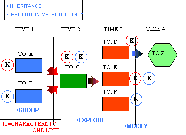
The use of a Territorial Object as an element of global data integration in a GIS requires the Territorial Object to be variable in time.
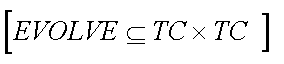
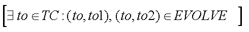
Territorial Object we have identified are subject to :these operations are fundamental in any SIT.
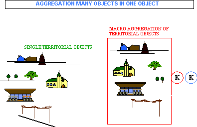
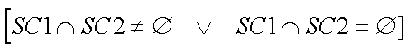
Aggregation is indeed the most important and used operation on territorial objects. The aggregation of heterogeneous elements to form a set which is itself a territorial object is a frequently used operation in all territorial management systems. Territorial elements may be stored both as single elements and as a set of minor elements : when we say "Park "we mean the park as a single collective element (Territorial Object) and as its single constitutive elements : the trees, park benches, play grounds, buildings etc..
They are all single Territorial Object.
Each element is managed singly for its maintenance, costs, verifications, but all together have own information and features as the object "Park". The single elements are almost always a set of statistical and normative polygons each with its own data, Links and K (characteristics).
Distinction and detail are typical of each application and of each attempt of description: anybody can view an object with a custom level of details. The "construction" is the typical detail level of common map sheets but it's quite obvious that the "building" is the fundamental element for statistical analysis, and that the element "apartment" is the minimal level for the technical accounting management : but the municipal and the General Land Office locate the single room as their basic management element. At a demographic - statistical level gathered information is about a single block.
Everybody sets his or her basic level and eventually the elements
defined by macro - aggregations
The aggregation in a single object of a series of elements, each of which is at its own level a set of many other minor elements, is called a macro aggregation.
Each territorial object at any detail and management level must
have homogeneous features and must be kept within the same laws
and rules both when it's a single object or an aggregation. The
territorial object must perform its task and must also be stable
in time, it should be multidimensional and be kept within a series
of rules such as unification, splitting, merging, recovering.
It should also be capable of inheriting feature, links, and Ks
from the territorial object(s) it derives from.
There are a series of laws and rules to comply with while defining
Territorial Objects and the algorithms to design
into the software for the gain of true benefits.

Acknowledgments
Delta CAD srl via Brennero 230 - 38100 , Trento.
deltacad@delta.it
RAUL MATTIVI Software engineer, Delisa.Trento
Chief of operating structure to realize OT Technology.
Permanent Address : Via Scuole 12 38042 Trento (TN) E-MAIL
deltacad@delta.it
NICOLA VALERIO Software engineer, Delisa.Trento
Permanent Address : Via Berlina 10/1 38040 Ravina ,Trento (TN) E-MAIL pippos@dei.unipd.it
Chief of operating structure to define OT Technology.
LORENZO ZENI, Software engineer GIS consultant,
Senior Project Manager (Delta CAD) ARC View and ArcInfo specialist.
Chief of operating structure to integrate OT Technology in ArcInfo environment.
E-mail lzeni@delta.it
Author information
Dr. Federico Del Freo, Architect, GIS consultant,
walking professor in Thematic cartography "Prof. Incaricato di cartografia tematica" at the Florence University of Architecture,
Senior project Manager (in Delta CAD) in SGC-open project, a wide range software for local community, full integrated with ArcView and ArcInfo.
Permanent Address: Via Mazzini 40, 24047 Treviglio (BG) Tel +39 363 303050 Fax +39 363 48744
E-Mail delfreof@ctrade.it
Dr. Gianni Rangoni Architect, GIS consultant,
Senior Project Manager (Delta CAD) ArcView and ArcInfo specialist.
Chief of operating structure to integrate OT Technology in ArcInfo environment.
Permanent Address: Frazione Cadine 148, 38070 Trento (TN).
E-MAIL rangoni@delta.it