Professional Certificate Program in Geomatics at Rutgers
University: First Year Experiences and Future Directions
AUTHORS
- Andrew T. Rowan, Center for Remote Sensing and Spatial Analysis, Rutgers University
- Lyna Wiggins, Ph.D., Center for Urban Policy Research, Rutgers University
- Scott L.H. Madry, Ph.D., Center for Remote Sensing and Spatial Analysis, Rutgers University
ABSTRACT
In September 1996, the Center for Remote Sensing and Spatial
Analysis (CRSSA) and the Center for Urban Policy Research (CUPR) of
Rutgers University launched a professional certificate program in
geomatics. The certificate program is an expansion of CRSSA's
long-running program in continuing professional education.
In response to demand from working professionals, the program was
established as a series of evening courses covering a variety of
topics in GIS, GPS, and remote sensing. Initial course offerings have
focused on hands-on training with specific software packages, while
planned expansion of the program will add courses focused on
application of the technology to various disciplines. In a general
sense, course content in the certificate program largely parallels
that of the undergraduate and graduate programs available in geomatics
at Rutgers, but the focus is on the pracictal needs of working
professionals with relatively limited time for training and
education.
The program has attracted students from a wide variety of
backgrounds. Some are already employed in GIS-related jobs and seek
to improve their skills, others are recent college graduates who want
to acquire employable skills to launch a career, and still others are
preparing for a career change. Initial response to the program from
all of these groups of students has been enthusiastic.
This paper describes the initial curriculum design, profiles the
students enrolled during the first year, evaluates the first year of
the program, and suggests future directions for development.
CONTENTS
INTRODUCTION
In September 1996, the Center
for Remote Sensing and Spatial Analysis (CRSSA), the Center
for Urban Policy Research (CUPR), and the Bloustein
School of Planning and Public Policy of Rutgers University launched
a professional certificate program in geomatics. The certificate program
is an expansion of CRSSA's long-running program in continuing professional
education.
In response to demand from working professionals, the program was established
as a series of evening courses covering a variety of topics in GIS, GPS,
and remote sensing. Initial course offerings have focused on hands-on training
with specific software packages, while planned expansion of the program
will add courses focused on application of the technology to various disciplines.
The program has attracted students from a variety of backgrounds. Some
are already employed in geomatics-related jobs and seek to improve their
skills, others are seeking employable skills to launch a first career,
and still others are preparing for a career change. Most of the students
enrolled in the courses plan to complete the requirements for a certificate.
PROGRAM INCEPTION
Program Origin: Individual Short Courses
CRSSA has offered short courses in GIS through the Cook College
Office of Continuing Professional Education for nearly ten years. The first
offerings were hands-on training courses using GRASS software. Shortly
thereafter, courses in ArcInfo were added. Then within the last two years,
new courses in ArcView and an introduction to the internet were created.
These courses were (and continue to be) offered as day-long, multiple-day
courses. The majority of students in these courses tend to be from the
region and commute to Rutgers for the classes, but a significant number
have come from other states or other countries.
Evening Courses
The day-long short course format has advantages and drawbacks. For individuals
who have an immediate need for training and can manage to get away from
work for several days, the short courses offer a quick way to gain the
needed expertise. But for others, who want to build up their skills for
their own professional development, the need to take time off from work
to participate in short courses is a substantial barrier.
In response to this, a series of evening courses was created. These
typically meet in seven sessions, once per week for two and a half to three
hours, beginning just at the end of the work day. This new format has opened
up the program to many professionals in the area who were previously unable
to take advantage of the daytime course offerings.
Wider Variety of Subjects
The evening program includes all of the subject areas that have been
offered as daytime short courses and quite a few new ones. Subjects that
might not have drawn enough students to be viable as short courses are
now proving quite successful in the evening program. (Subject areas are
detailed below, in Curriculum.)
Tangible Goal: the Professional Certificate
The professional education program at Rutgers University/Cook College
has for many years offered programs leading to certificates in other fields.
The certificate in geomatics has already proven to be a very popular idea;
80% of the course participants surveyed recently indicated that they planned
to complete the program for a certificate as opposed to simply taking a
few specific evening courses. The certificate itself is clearly viewed
by many as a valuable credential, in addition to the technical proficiency
leading up to it.
CURRICULUM
Current Course Offerings
Since the certificate program was launched, courses have primarily been geared toward students with little or no experience in GIS/GPS/remote sensing. The emphasis has been on introductory concepts and hands-on training in the use of popular application software. One introductory course that builds a foundation of GIS and remote sensing principles serves as the prerequisite for all the other courses.
The availability of university faculty to serve as instructors has enabled us to cover a wider range of topics than is commonly available through corporate training organizations. In particular, we have tapped into CRSSA's substantial expertise in remote sensing and digital photogrammetry and offered courses in these areas in addition to the more mainstream GIS topics.
Courses offered through the evening program (Up-to-date information is also available on the web):
- Fundamentals of GIS: Principles and Applications
- Desktop Mapping: ArcView, Mapinfo, and Geomedia
- Introduction to ArcInfo
- Advanced Applications of ArcInfo
- Arc Macro Language
- Programming ArcView with Avenue
- Fundamentals of Remote Sensing I and II
- Soft Copy Photogrammetry I and II
- Introduction to the NAVSTAR Global Positioning System
- Introduction to the Internet for Environmental Professionals
Planned Additions
Courses on the desktop mapping programs have proven to be the most popular; in response to this (and to the increasing complexity and power of these programs), the desktop mapping class has been separated into two classes. An entire course will be devoted to ArcView, and Mapinfo and Geomedia will be covered in a second course. Other new courses already scheduled for the coming year will round out the program by covering some core topics not necessarily related to specific software systems. These are:
- Design and Management of Spatial Databases
- Unix techniques for GIS Users
- Windows NT System Administration
As the program matures, we plan to expand in three main areas. One will be to include training in a few other software systems (such as ArcCAD and MGE). The second will be to increase the offerings oriented toward application development to include such topics as MapObjects and perhaps advanced work in Avenue. The third will be to compliment the software training with courses focused on techniques for applying GIS, GPS, and remote sensing to specific professional disciplines (for example: public health, environmental protection, transportation, or marketing). Accomplishing this will involve reaching beyond our current group of instructors from within the university to include experts from the regional GIS community.
STUDENT PROFILE
Before the initiation of the evening program, the full-day short courses at CRSSA have attracted two main groups of students. Most students were sent by their employers (with the employers covering the costs in most cases) to meet an immediate need at their organizations for GIS competency. A smaller portion were recent college graduates seeking skills to help
them land their first jobs. Because of the necessity to take time off from work, only occasionally would the short courses draw people who were currently employed, but improving their skills on their own initiative in order to change jobs.
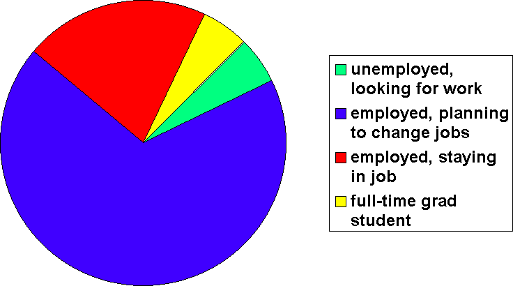 With the advent of the evening program, there has been a sharp increase in participation among this third group of students. In our recent survey of program participants, 68% indicated that they were employed but planning to look for a new job. Paralleling that change, the proportion of students paying the complete cost of their courses themselves has risen from a fairly small fraction to nearly one third. In terms of longer-term career plans, half the students are incorporating GIS into their current careers, 15% are just starting careers and want to include GIS, and 15% are making a complete change of careers to GIS-related fields.
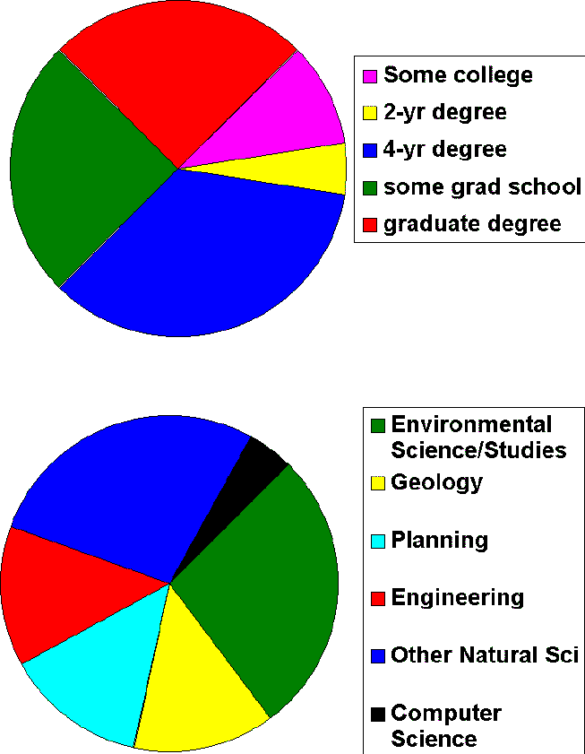 The great majority of the students are college graduates. Of those surveyed, 85% hold bachelor's degrees and 25% have graduate degrees. Ages range from early 20's to 50's, with most of the students in the younger end of that range: over half are under 30, and 85% are under 40. Among the degreees held by the students, the fields of study represented are dominated by natural sciences. In order, the most common disciplines are environmental science/environmental studies (30%), geology (15%), engineering (various types, 15%), environmental planning (15%). Other disciplines include geography, wildlife ecology, archaeology, and computer science. The high proportion of natural scientists is very likely a result of the way the program has been marketed to date. Cook College is the agricultural/environmental college of Rutgers University, and Cook's professional education program is a long-running, well-established operation with a large base of former students and other contacts in the environmental field. The program has been promoted most heavily through those channels, and as a result most of the students thus far have been environmental
professionals. This balance may very well shift as the program becomes more widely known.
The great majority of the students are college graduates. Of those surveyed, 85% hold bachelor's degrees and 25% have graduate degrees. Ages range from early 20's to 50's, with most of the students in the younger end of that range: over half are under 30, and 85% are under 40. Among the degreees held by the students, the fields of study represented are dominated by natural sciences. In order, the most common disciplines are environmental science/environmental studies (30%), geology (15%), engineering (various types, 15%), environmental planning (15%). Other disciplines include geography, wildlife ecology, archaeology, and computer science. The high proportion of natural scientists is very likely a result of the way the program has been marketed to date. Cook College is the agricultural/environmental college of Rutgers University, and Cook's professional education program is a long-running, well-established operation with a large base of former students and other contacts in the environmental field. The program has been promoted most heavily through those channels, and as a result most of the students thus far have been environmental
professionals. This balance may very well shift as the program becomes more widely known.
CONCLUSIONS
Eight months after the inception of the program of evening courses leading to a "Professional Certificate in Geomatics," awarded by the Cook College Office of Continuing Professional Education, the program has exceeded the initial projections for numbers of students enrolled. Classes
have averaged 18 students, with several classes hitting the enrollment limits imposed by room size. The program was launched with a suite of courses focusing on software training; future expansions of the curriculum will include courses oriented toward application of the techniques to specific professional disciplines. The opportunity to complete the entire program through evening courses and the tangible end represented by the certificate have combined to make the program very popular among people interested in increasing their attractiveness on the job market.
AUTHOR INFORMATION
Andrew T. Rowan
- Sr. Program Development Specialist, Center for Remote Sensing and Spatial Analysis, Rutgers University
- Mail address: Environmental/Natural Resource Science Bldg., Room 156, Rutgers University, New Brunswick, NJ 08903-0231 USA
- Phone: (732) 932-1582
- Fax: (732) 932-2587
- E-mail: rowan@crssa.rutgers.edu
Lyna Wiggins, Ph.D.
- Associate Director, Center for Urban Policy Research, Rutgers University
- Mail Address: CUPR, 33 Livingston Avenue, Suite 400, New Brunswick,
NJ 08901-1982 USA
- Phone: (732) 932-3133
- Fax: (732) 932-2363
- E-mail: lyna@rci.rutgers.edu
Scott L.H. Madry, Ph.D.
- Senior Associate Director, Center for Remote Sensing and Spatial Analysis,
Rutgers University
- Mail address: Environmental/Natural Resource Science Bldg., Room
133, Rutgers University, New Brunswick, NJ 08903-0231 USA
- Phone: (732) 932-1581
- Fax: (732) 932-2587
- E-mail: madry@crssa.rutgers.edu