The Western Riverside Council of Governments (WRCOG) is a joint powers authority comprised
of the fourteen cities in the western portion of Riverside County, and the County of Riverside.
The population of the WRCOG region (Figure 1) was approximately 900,000 in 1990 and is projected to
exceed 2,000,000 by 2015. Transportation and air quality issues are inextricably linked to the
growth, economic well-being and quality of life in the region.
The cities of Temecula and Murrieta are experiencing some of the highest growth rates in the WRCOG region. A proposal was developed to create a local transportation model to aid in the transportation planning efforts for the area surrounding these cities. The goals of the project were to:
-Create a local transportation model which was useful for local transportation and land use planners and consistent with regional models;
- Refine future year socio-economic projections; and,
-Pilot the integrated use of geographic information systems (GIS) and transportation
modeling tools.
This paper will describe the transportation model pilot, the process used to achieve its goals,
current status, and the further steps which are currently underway in the WRCOG region.
The Western Riverside Council of Governments (WRCOG) is a joint powers authority comprised
of the fourteen cities in the western portion of Riverside County, and the County of Riverside.
WRCOG provides an instrument to address issues of common interest to the member
jurisdictions. Over the past six years the primary issues of interest have been growth,
transportation, air quality, and solid waste; though a variety of other topics have been addressed
from libraries to GIS coordination to graffiti.
Together, the WRCOG members face the challenges of being one of the fastest growing areas of
the country. The population of the WRCOG 2000 square mile region was approximately 900,000
in 1990 and is projected to exceed 2,000,000 by 2015. Transportation and air quality issues are
inextricably linked to the growth, economic well-being and quality of life in the region.
The cities of Temecula and Murrieta are experiencing some of the highest growth rates in the
WRCOG region. A proposal was developed to create a local transportation model, tied to GIS,
as an aid in the transportation planning efforts for the area encompassing and surrounding these
cities. The WRCOG region is composed of five "Area Planning Districts" for coordination and
sub-regional planning purposes. The modeling pilot contained a major portion of the SouthWest
Area Planning District, giving the project its name. This project was jointly funded by the two
cities and WRCOG, with significant assistance from the Southern California Association of
Governments (SCAG) and the County of Riverside. CalTrans District 8 was also instrumental in
the successful completion of this project.
Specifically, the goals of the project were to:
-Create a local transportation model which was useful for local transportation and land use planners and consistent with regional models;
- Refine future year socio-economic projections; and,
-Pilot the integrated use of geographic information systems (GIS) and transportation
modeling tools.
These goals were selected for a variety of reasons:
-Compliance with California Government Code Sections 65089.3 (a) and (c) require local
land use planning decisions to be made in consideration of a transportation model
consistent with the regional transportation model. This led to an early decision that the
model developed must meet the established benchmarks for consistency findings.
-Much of the development of future year socio-economic projections is performed through
SCAG on a regional basis. It was felt that local review and feedback on these projections
would both improve the quality of the projections, and increase local use and belief in the
figures.
-Finally, WRCOG has pioneered the use of GIS as a review and analysis tool for regional
data and as tool for local planning. The Western Riverside Information Network (WRIN)
was established in 1992 to provide a basic GIS capability for all WRCOG members.
WRIN's success in establishing that capability led to the desire to add further
transportation information to the available set of GIS data. Linking a comprehensive set
of transportation modeling data with the available land use and other planning data
provides a powerful desktop tool for local government.
Early in the process, and key to its successful completion, the consulting firm of Hank Mohle and
Associates (HMA) of La Habra, California was contracted to develop the local model. Ed Norris
of HMA has been the lead on most tasks during this project. The methodology to develop the
model has been:
-Collect existing transportation models, both local and regional;
-Collect existing traffic count data;
-Build local Traffic Analysis Zone (TAZ) structure for the area, consistent with regional model zone boundaries and census geography with local input on zone boundaries;
-Request SCAG develop socio-economic data for new zone structure for both base and future years;
-Refine SCAG socio-economic data through meetings with local planning and transportation staffs;
-Develop TRANPLAN traffic model for base and target years;
-Submit model to Congestion Management Authority (Riverside County Transportation Commission) to determine consistency with regional model; and
-Deliver completed model to local jurisdictions for use.
Several portions of this methodology used the ArcView GIS software (© Esri, Inc.) as an aid to
project development. ArcView 2.1 was used on Pentium based personal computers using both
the MicroSoft Windows 3.11 and Windows'95 operating systems.
Construction of the local TAZ structure used ArcView to display and plot the new zones. This
local zone structure contained over 600 zones for an area previously represented by 6 zones in the
regional model and 46 zones in the Riverside/San Bernardino model (Figure 2). These smaller
zones were much more recognizable in the "real world" and provide a greatly improved basis for
prediction and planning.
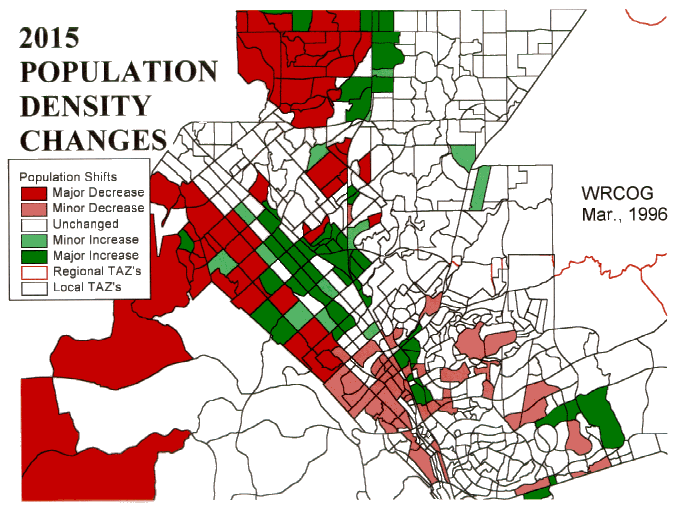
Perhaps the most dramatic use of the GIS tools was in the review and refinement of the socio-economic projection information. Groups of transportation and land-use planners from the local
jurisdictions were brought together to review the initial socio-economic projections received from
SCAG. The 600 small local zones made it possible to review population, employment and
housing projections for recognizable areas. The review process moved high density housing out
of zones which currently contain hospitals. Employment projections were increased in industrial
commercial areas near an airport and decreased in open space areas. The use of ArcView to
display and represent the information helped tremendously during these review sessions (Figure 3). This improved socio-economic data was provided to SCAG as input to future
modeling efforts.
The completed model was delivered in ArcView format to the jurisdictions. This delivery method
allowed the transportation links to be draped over land use, vegetation, general plan, or other
information. Each link in the transportation model contains attributes for volume, capacity, free-flow travel time, loaded travel time, number of lanes, etc. These attributes can be combined in
ArcView to show classifications based on congestion or traffic volume (Figure 4).
The standard TRANPLAN (© Urban Analysis Group) transportation modeling software was used
in this project. This aided in model conformity and provided the technical platform to produce
projected volumes for each of four daily periods (morning peak, afternoon peak, mid-day and
night) in each direction for each link. This project used the TPARC routines to transfer data from
TRANPLAN to ArcView, though future efforts hope to use network conflation tools to
accomplish this task.
Under California law, a "Congestion Management Authority" (CMA) is selected for each county
to oversee the provisions of the Congestion Management Plan. The CMA is responsible to ensure
the provisions of the plan are implemented. A portion of this responsibility includes making
determinations as to whether a given local model is consistent with regional transportation
modeling.
Initial results of the SouthWest Area Planning District Transportation Modeling Pilot have been
very positive:
-The priority modeling area of Temecula, Murrieta and the surrounding County area has been modeled and reviewed by the Congestion Management Authority. While we are awaiting formal notification, it is our understanding that the tests have been met for a consistency finding;
-The revised socio-economic projection information has been provided to SCAG and will be incorporated as input to the 1997 Regional Transportation Plan;
-The results of the modeling effort are already being utilized in a transportation corridor study for the I-15/215 through Temecula and Murrieta;
-The local zone structure developed for the transportation model has been supplied to the County of Riverside for use in a detailed land use planning study in the area;
-The completed model in ArcView format has been supplied to the participants for their internal use; and,
-SCAG has been very pleased with the results of this pilot project and has funded the
development of two additional local models for other Area Planning Districts in the
WRCOG region. In addition, the creation of more detailed local networks and socio-economic data has received high priority as a regional objective.
In coordination with SCAG, the local jurisdictions and other regional agencies with an interest in
planning and transportation, we look forward to completing a model for the remainder of the
SouthWest Area Planning District, and to eventually implementing a complete set of local models
for the entire WRCOG region.
Alan Crouse
, Director, Information ServicesWestern Riverside Council of Governments
3880 Lemon Street, #300
Riverside, CA 92501
(909)787-7985
(909)787-7991 Fax
www.wrcog.cog.ca.us