Performed in Strasbourg (France), the European capital, an experiment on the potential of SPOT data associated an end-user, the Strasbourg Urban Planning and Development Agency, ADEUS, and an image processing and GIS resource centre, SERTIT. This study demonstrated the operational use of SPOT data for deriving pertinent thematic information related to urban territory description and evolution. Convincing results led to the constitution of a partnership around SERTIT, federating diverse regional end-users for a common and regular thematic exploitation of remote sensing data over the Alsace Region.
Finalised in 1991, an experiment on the potential of SPOT data in the field of regional and urban planning, performed in Strasbourg, the European Capital, within the framework of the French Space Agency�s (CNES) SPOT AVAL programme, associated an end-user, the Strasbourg Urban Planning and Development Agency ADEUS (l�Agence de Developpement et d�Urbanisme de l�Agglomeration Strasbourgeoise), and the Remote Sensing, Image Processing and GIS (Geographical Information System) resource centre SERTIT (Service Regional de Traitement d�Image et de Télédétection) to whom is confided the exploitation of the data (DIEBOLD et al. 91). The first step of this programme was to demonstrate the feasability of deriving pertinent thematic information from high resolution satellite images, like SPOT-HRV data, responding to planner�s requirements of describing urban areas and their evolution. This study led to the realisation of both an illustrated brochure "Strasbourg, the City: Urban Development and Changes" printed in 1992 and a computer demonstration floppy disk edited in 1993 and both presented to potential end-users, with a particular emphasis on Alsace Region organisations (SERTIT 92). Due to their expressed interest, the transcription of the processing method, elaborated jointly with the end-users, into a specific image processing package adapted to SPOT data, was then realised by SERTIT using ERDAS-Imagine software and is actually used to process high resolution satellite images for urban territory description (THOLEY 94, THOLEY 95).
Out of the demonstrated feasability and operational use of both the satellite data and the image processing techniques, these actions received the approval of the French Infrastructural Ministry (Ministère de l�Equipement), the French Space Agency (CNES) and SPOT-Image. They led the way, through the presentation of convincing results, to the constitution, in 1995, of a SERTIT anchored end-user group. This partnership brings together diverse state services, regional authorities, local administrations, urban development agencies, and regional parks, and permits, through regular SPOT image acquisitions, the common exploitation of the data, describing the Alsace Region territory according to a common thematic system, and hence, each partner has a common information layer which is and will be similarily and regularily up-dated.
The general questions posed before this project were :
Firstly, are SPOT images capable of disassociating themes pertinent to
urban planners ?
Secondly, can these information prove complementary to traditional urban
descriptions and thus enrich an urbanist�s perspective ?
Finally, through the timely acquistion of data can one follow urban spatial
and tissue evolution ?
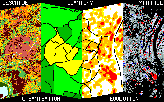
Due to this evaluation programme, it has been shown that the landcover of an urban area can be described using certain themes but these are transversal to conventional urban taxonomies (figure 1). Radiometric data recompose the urban landscape into more or less homogenous spaces in the mineral, vegetal or hydrographical domains. Therefore these spaces can be reread in complement to classical urban functions which is interesting as these information relate to the spectral characteristics of materials, to the size of objects and their inter-relative spatial distribution, thus enriching the knowledge of the global urban structure (figure 2). This structural information can describe, for example, the urban vegetal pattern, contact zones or transitions between built up and rural spaces or urban heterogeneties revealed by large developments.
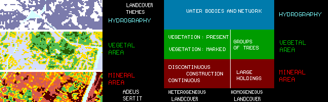
figure 1: Main landcover themes with their biophysical correspondance
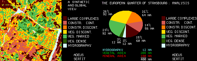
figure 2: The European Quarter of Strasbourg: Landcover description
and statistics
Urban change analysis between two dates was also part of this experiment,
which led to the following observations: present urban dynamic change analyses
are often only partial whereas, to the planner, regional and local scale
knowledge of these changes are becoming more important. Results have shown
that the urban dynamic can be ascertained, by using either panchromatic
P or multispectral XS data.
Satellite data, quasi instantaneous over a large area, are a powerful
territory analysis instrument. They permit a synthetic view of multitemporal
urban change, complementing traditional methods, and a detailed localisation
of these changes for each administrative unit (figure 3). The Strasbourg
or Alsatian projects, realised by SERTIT for its partners, are good examples.
Nevertheless careful analysis has demonstrated the interest of acquiring
data at much the same period of the year, and therefore vegetal state,
in order to minimize perceived changes not due to urban tissue dynamics.
If surface measurements of the dynamics are tenuous due to image pixel
size (10m or 20m), the extrapolation to urban quarters or blocks, of change
isolines or variation/stability indeces, constitutes a pertinent indicator
of urban modification (figure 4).
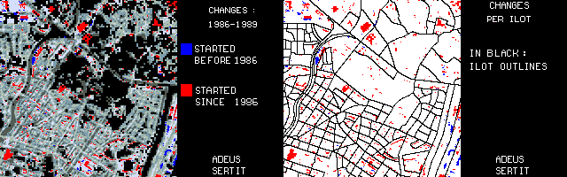
figure 3: The European Quarter of Strasbourg:Chronology of changes
by administrative units
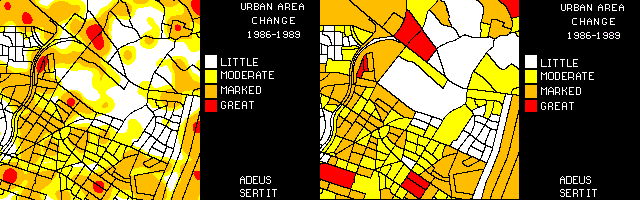
figure 4: The European Quarter of Strasbourg: Quantification
and spatialisation of changes by administrative unit
Concerning pertinent observation scales, these depend directly on the spectral richness and spatial resolution offered by SPOT or other satellite observation systems. They can meet most planning requirements in regional development projects and therefore usually correspond to a scale range from 1:100000 to 1:10000 which seems to be the extreme limit for actual SPOT image interpretation.
In order to insure the reproduction of results of such urban territory descriptions, several conditions have to be respected. This reproductibility depends on certain factors including on one hand, the similarity of image acquisition parameters like period/season of acquisition, sun illumination, and image geometry, which can be partially overcome with orthorectification procedures, and on the other hand, perfect image co-registration for further change analysis. Urban vegetation can be taken as an example: to a planner, the state of the vegetation at a given date may be less important than a good knowledge of the extent of urban vegetal surfaces which therefore, necessitates on one hand, the processing of images acquired at appropriate periods, for vegetation detection and stabilisation, and on the other hand, the comparison of similar images in order to insure the elimination of vegetation state artefacts in urban change analyses.
Further, the integration of the SPOT derived information into GIS offers interesting propects. These thematic observations, digital and repetitive, open up the possibility to urbanists and planners of regularly monitoring urban landcover and dynamics over wide areas whilst using homogenous data sources. More over, each end-user can perform or ask for specific data analysis, statistics, and representation that complete traditional urban and land planning, global and local, approaches (figure 5).
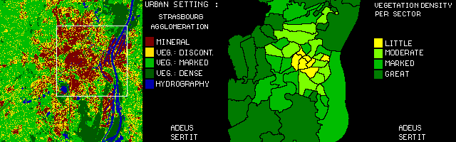
figure 5.Strasbourg : Landcover and Vegetal density spatialisation
by administrative unit
Resulting from preliminary feasibility studies, performed in order to describe urban areas with pertinent thematic information from high resolution satellite data processing, the landcover themes that were defined, and are presently extracted and furnished to end-users, are listed in nine categories:
- Hydrography
- Dense vegetation
- Marked vegetation
- Discontinuous vegetation (light vegetation in rural areas)
- Interstitial vegetation (light vegetation in urban areas)
- Light urban development (discontinuous constructions)
- Dense urban development (continuous constructions)
- Large infra-structure/commerial and mineral extraction developments (large
complexes)
- Mineral surfaces in rural areas
These classification themes relate to bio-physical surface descriptions according to their inherent nature i.e. mineral, vegetal or water:
Urban, mineral
The large infra-structure/commerial and mineral extraction developments
theme (large complexes) corresponds to highly mineralized recently
built surfaces comprising comercial, industrial and administrative sectors,
tower blocks, and extensive concrete plus tarmacadam surfaces. The minimum
size for this class is 2000m2 per object.
Dense urban development (continuous constructions)
includes heterogenous old urban quarters like town centres and dense residential
areas plus dense railway and autoroute infrastructure.
The class light urban development (discontinuous constructions)
is composed of heterogenous surfaces, mostly mineral surfaces with some
vegetal components, being comprised of residential areas fronting onto
large roads and other thoroughfares and lighter infrastructure.
Vegetal domain
The following class denotes the passage from suburbia to peri-urban
areas:
The class light vegetation corresponds to mostly vegetal surfaces
with some mineral component; it is subdivided in two classes: interstitial
vegetation for urban areas and discontinuous vegetation for
rural areas.
Discontinuous vegetation includes non continuous or sparse
vegetation, contact space between crops and rural lanes, fringes of infrastructure
or of watercourses in rural zones.
Interstitial vegetation includes mostly vegetal urban surfaces
corresponding to light density housing, small, vegetation surrounded, roads,
gardens and peri-infrastructural surfaces.
Marked vegetation is comprised of urban parks and lawns plus
rural prairies and developed crops.
Dense vegetation corresponds to groups of trees in urban areas
and to wooded massifs or forests in rural zones.
Water
The class hydrography represents the larger features of the
hydrographic network be they river or other water surfaces.
Residual theme
Mineral surfaces in rural areas regroups all non urban mineral
surfaces like bare soil and road infrastructure.
These different thematic descriptive information are extracted from high resolution earth observation data like SPOT XS and P images. The image processing methods involved in such an image classification and territory description, differs from conventional classification techniques (supervised or not); these generally encounter problems in spectrally separating typical radiometrically mixed regions like the class light urban development, which is mostly mineral with some vegetal components, and the class light vegetation (interstitial or discontinuous), which is mostly vegetal with some mineral components. Such a description involves and thus results from advanced segmentation procedures of specific thematic indices and neo-image combinations defined by SERTIT during the preliminary feasibility studies.
After having successively demonstrated to potential end-users, first the potentiality and interest, and then, the possible reproductibilty and operationality of deriving thematic urban-oriented information from SPOT images, a regional partnership of remote sensing data end-users was constitued in Strasbourg for the Alsace Region (figure 6). Beside SPOT Image, the remote sensing data provider, which regularly furnishes data acquired over the Alsace Region, and SERTIT, the value-added thematic information provider, which manages and regularly processes the images for both a predefined and up-to-date landcover description and dynamic assessment, and which assumes result validation jointly with an experienced end-user, the Strasbourg Urban Agency ADEUS, this partnership federates urban and land planning related end-users in the two Alsace departments and comprises diverse state services, regional authorities, local administrations, urban development agencies and regional parks.
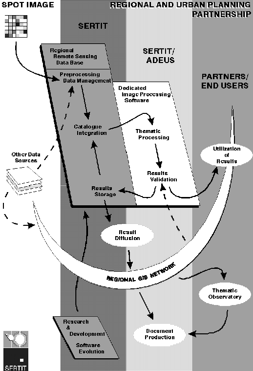
figure 6. Partnership Organisation and Information Diffusion
The advantages of such a partnership are obviously numerous. On one hand, it is to insure over the Alsace Region and its two departments, a perenity of common and regular remote sensing data acquisitions, thus progressively constituing a complete and unique centralised Alsace Remote Sensing Integrated Database, whilst on the other hand, it insures a continuous, common and regular, landcover description and updating, thus alimenting progressively a complete Thematic Regional Geographical Database which, by the way, also allows access to a regular monitoring of urban changes and evolution over the Alsace Region and its metropole and European capital Strasbourg.
In this partnership, SERTIT is the interface between the data provider SPOT Image and the end-users, and acts as a resource centre, in digital image processing and in remote sensing derived information layer integration into the end-user�s GIS. SERTIT assumes the management of the Satellite Image Database, the digital image processing chain, within its dedicated software, and the management of the Thematic Geographical Information Database. SERTIT is in charge of the geographical information diffusion inside the end-users network. According and adapted to the respective end-users needs and equipment (post-processing or analysis capacities, hardware, software and specific materials) different data types and file formats can be furnished (table 1).
|
User Practices and Data needed |
|||||
|
Statistical Information |
Cartographic Information |
Statistical Processing |
Process Georeferenced Data |
||
|
No equipment |
A |
B |
C |
D |
|
|
User Equipment |
Statistical Software |
E |
B |
E |
D |
|
Visualization/Edition Software |
A |
F |
C |
F |
|
|
GIS Software |
G |
G |
G |
G |
End-user typology:
User type A:
Technical document with statistical table outputs:
Example: landcover statistics per class and per commune, urban growth per
canton, ...
User type B:
Thematic cartography output at a given scale:
Example: Regional Landcover cartography, Departmental Change cartography,
...
User type C & D:
With SERTIT acting as a skills and resouce centre for the end-user:
Example: The user employs SERTIT�s equipment to meet specific requirements
User type E:
Alphanumerical data files produced at SERTIT are exported/integrated into
end-user�s software for their own specific post analysis:
Example: EXCEL file on landcover statistics
User type F:
Digital cartographic products exported as CAD files to the user:
Example: digital raster image file of landcover description (gif, TIFF,...),
digital vector file of thematic edges for drawing software (DXF,...)
User type G:
Digital cartography and/or statistical information, derived from remote
sensing data, are exported to the user�s GIS in their required format;
they then have full usage of the data
This organisation furnishes the various end-users homogenous and coherent information on Alsace. The data having been thematically validated, their archival enriches the database and through use the software. The diffusion of cartographic results to the regional GIS�s should contribute to make reccurent the use of SERTIT�s dedicated image processing software, and hence be favourable to its evolution, when specific demands and studies are expressed by one or other of the end-users. Finally, within the development of communication networks, the results, as obtained, would be, in term, directly integrated into the regional GIS network which is presently being put in place.
Responding to planner�s requirements of describing urban areas and their evolution, this dedicated software, operational in 1995, is used in different projects (see SERTIT�s WWW Server): observatory of the socio-economic and environmental impact of a motorway section that runs close to the Rhine in northern Alsace (figure 7), Executive Plan of the Urban Community of Strasbourg (Communauté Urbaine de Strasbourg) and of the German town Kehl, landcover and its evolution over an 8 year period for the two departments comprising the Alsace Region (figure 8), projects for which the result�s validation is jointly assured with the regional and urban planners.
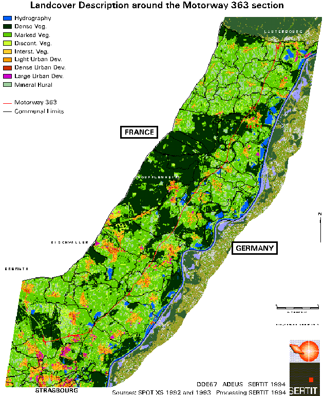
figure 7: Landcover description around the 363 motorway section
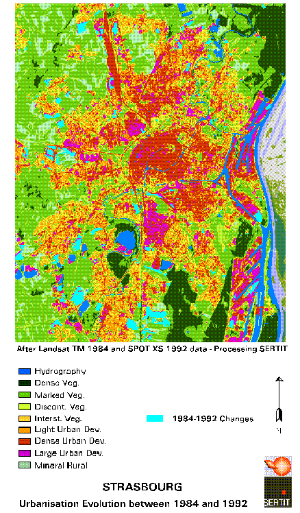
figure 8: Strasbourg, Urbanisation evolution between 1984 and
1992
This partnership has shown that, already in the case of Strasbourg and its hinterland, it is possible to transcend frontiers and differing information sources by following planning policies on either side of the Rhine in Alsace, France, and Baden-Würtemburg, Germany, whilst exploiting the same and homogenous information source.
Our common ambition for SPOT satellite data and the ERDAS-Imagine development tools combined to ARC-INFO, or other GIS post analysis capacities, in opening to other users confronted with, within other contextes, urban growth problems, regional planning, economic development combined with environmental and landscape conservation, is to bring outside administrative frontiers or state boundaries, solutions that establish remote sensing as a valuable instrument in environmental dynamic analysis, monitoring, and future territorial planning.
The authors would like to express their acknowledgments to:
- Francis DIEBOLD from the Strasbourg Urban Planning and Development Agency,
ADEUS, who contributed, within this study, to specify end-user requirements,
to validate image processing methods and results, and also for his active
animation of the end-user partnership;
- Veronique MARIETTE from the French Space Agency, CNES, who supported
this study within the framework of a SPOT AVAL programme;
- SPOT Image and Esri France for their interest on SERTIT�s projects.
DIEBOLD F., FRAIPONT (de) P. et THOLEY N., 1991 - Évaluation des potentialités des images SPOT dans les domaines de l'urbanisme et de l'aménagement, Programme SPOT-AVAL, Rapport CNES, 130p.
SERTIT, 1992 - Strasbourg, The City Cue: Urbanisation and Evolution; SERTIT - CNES - ADEUS - STU Brochure, 12 p. + floppy disk demonstration.
THOLEY N., FRAIPONT (de) P., DIEBOLD F. et SCHNEIDER J., 1994 - Mise en place opérationnelle d'un outil de traitement des données SPOT pour l'urbanisme et l'aménagement. Rapport CNES / Ministère de l'Equipement, 54 p + 40 fig.
THOLEY N., 1995 - Evaluation des produits SPOT XS, P+XS CNES, P+XS ARSIS en milieu urbain et périurbain, Programme SPOT-AVAL, Rapport SERTIT-CNES, 71p.
Nadine THOLEY, Image Processing Project Manager
Service Régional de Traitement d�Image et de Télédétection
(SERTIT)
Parc d�Innovation, boulevard Sébastien Brandt,
F 67400 Illkirch, France
tel: +33 (0)3 88 65 52 00;
fax: +33 (0)3 88 65 51 99;
email: sertit@sertit.u-strasbg.fr
http://sertit.u-strasbg.fr
Stephen CLANDILLON, GIS Project Manager
Service Régional de Traitement d�Image et de Télédétection
(SERTIT)
Parc d�Innovation, boulevard Sébastien Brandt,
F 67400 Illkirch, France
tel: +33 (0)3 88 65 52 00;
fax: +33 (0)3 88 65 51 99;
email: sertit@sertit.u-strasbg.fr
http://sertit.u-strasbg.fr
Paul de FRAIPONT, Director of SERTIT
Service Régional de Traitement d�Image et de Télédétection
(SERTIT)
Parc d�Innovation, boulevard Sébastien Brandt,
F 67400 Illkirch, France
tel: +33 (0)3 88 65 52 00;
fax: +33 (0)3 88 65 51 99;
email: sertit@sertit.u-strasbg.fr
http://sertit.u-strasbg.fr