W. Brandon Moore
In today's world, access to information is important to people. People make better and quicker decisions when they have easy access to good information. GIS (Geographic Information Systems) technology and public information has typically been limited to being maintained and used by only a few people, usually in a government setting. For example, cadastral or parcel information, both mapping and attribute information, has always been available to the public, but only in hard copy formats and at only one or two locations within a government complex. Hard copy formats meant copying and splicing maps and data together. It also meant flipping pages back and forth to look up values.
In Ashe County, North Carolina, a Parcel Land Use System is providing a wealth of information on 30,000 parcels through an easy to use program accessed by most Ashe County departments, a walk-up public access system, on-line dial-in service, and a stand-alone CD containing program and data.
Residents (especially surveyors, lawyers, real estate agents, and state and local agriculture personnel) using the public access system often comment that locating property lines and finding property owners with a click of the mouse is easy. Mapping office employees love the system, too, as their assistance locating information is needed less, giving them more time for other tasks like maintaining the County's digital mapping. The system includes county-wide digital orthophotos, parcels, roads, strucutres, streams, soils, and addresses that can be displayed, manipulated, and printed.
Clicking on any of the links below will take you to the appropriate section of the paper. Also, clicking on any of the images will take you to a larger representation of that image.
What is PLUS?
Who Uses PLUS?
Plans for Future Development
Author's Information
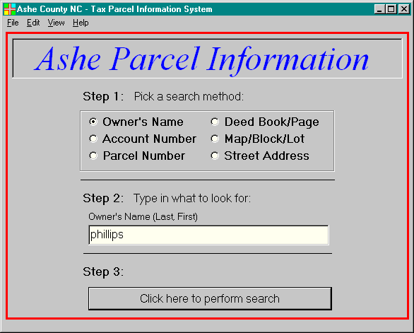
In Ashe County, North Carolina, making the County GIS data available to all citizens is important. Making it available in a quick and easy manner is the key to its success. Anderson & Associates worked with Ashe County to develop GIS layers like roads, structures, streams, parcels, addressing, soils, and digital orthophotography. Using these GIS layers, we developed a Public Access program called PLUS -- Parcel Land Use System. We used Visual Basic 5.0 and Esri's Map Objects to create a system that most anyone could sit down and use. The program has an opening screen that has three steps:
1. Select a search option (there are six options)
2. Type what to search for, such as last name or address,
3. Process the request
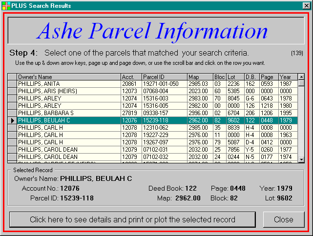
Another screen will open showing the matching results. For example, if a person types in a search by name and types "Phillips", then a list of all Phillips who own property would be displayed with information such as Parcel ID and Deed Book and Page. Now the person is asked to select one of the records and click a button on the bottom to see all the data attributes associated with the parcel.
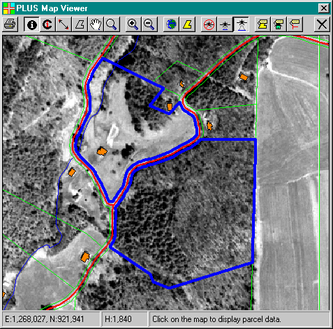
This next page displays all the data attributes related to the parcel of interest. These attributes come from the County Real Estate Department who maintains the database storing the attributes shown on the sreen below. Options are then available on the bottom of the screen to either print the data, cancel and go back to the previous screen, or plot the parcel. Plot tells the program to find the parcel in the County, pull up the mapping, and highlight the parcel.

This is the point at which Map Objects is used. The map screen has buttons which allow the user to zoom in and out, turn orthophotos on and off, identify other features such as other parcels, roads, and structures, print the map, measure distances or areas, and label features.

For years the public came to the Ashe County mapping office to look up information related to parcels. They would look up a parcel by owner's name and find the parcel ID and map number. Then they would pull out a large hard copy map of the area they were looking for and make a photocopy, then hand-write ownership information. This process was tedious when the parcel of interest fell on the corner of four tax sheets. The County mapper and employees were constantly interrupted with questions.
Now the public accesses all information digitally. One way is through a public access terminal installed at the County mapping office. Another way is by purchasing a subscription to a CD, updated every three months, which contains all the County data including 6' orthophotos. The next step the County will take will be to place the data on the internet. The system has been running for over a year and a half. It has been successful in limiting the traffic of common visitors such as attorneys, surveyors, and real estate agents.
Not only has it saved the County money by limiting interruptions, but also by helping the private sector save time and money through more efficient and improved access to digital mapping. Surveyors can cut deed and parcel research time in half. Real estate agents can respond more quickly to their clients. Attorneys save time in research for cases involving land ownership. County and State agricultural departments use it to respond quickly and more accurately to soil and farming issues. Those in the private sector who once had to make constant trips to and from the County Mapping Office stay at their office making better use of their time.
The County is taking steps to implement a Local Area Network, over which the County GIS can be shared. Currently departments are making use of the GIS through CDs.
The next goal for the County is to get the program available on the internet with the Map Objects Internet Map Server. This would then give people all over the world access to Ashe County's GIS. Ashe County is a mountainous area with the Blue Ridge parkway along one border, and has become a retirement area and vacation home for many people. By giving people access through the internet, people from anywhere will be able to search for land they could possibly purchase.
W. Brandon Moore, Geographic Information Systems Manager
Anderson & Associates, Inc.
100 Ardmore Street
Blacksburg, VA 24060
www.andassoc.com
ph. (540) 552-5592
fax (540) 552-5729
e-mail: moore@andassoc.com