I. The Harvard Map Collection: History of our GIS Activity
The Harvard Map Collection was one of the original participants in the ARL/Esri GIS Literacy Project launched in 1992. Our collection came to the project with its well known paper-based collection of 400,000 maps and 10,000 atlases. The paper collection includes extensive modern holdings along with manuscript maps; historical collections on the American Revolution, the Civil War, early Ordnance Survey maps; and representative examples of maps from the world's great cartographers. The atlas collection includes materials from the fifteenth century to the present, including authors such as Mercator, Ortelius, and Ptolemy.
In spite of these distinguished collections, our library was aware of the increasing amount of digital cartographic data becoming available from a variety of government and commercial sources. Few libraries have been able to ignore this changing technological paradigm, and we began planning acquisition, storage, and access strategies for these new cartographic information sources.
It was the 1990 Census and TIGER boundary files that initially aroused our interest in GIS technology. Essentially, we came to the data via geography, the TIGER files. We were soon using Wessex boundary files and data to create maps and watching surprised students walking away from the Library with colored maps. Student were also beginning to ask questions regarding the spatial analysis capabilities of GIS software and the ability of the software to incorporate new geographic and attribute data. The Map Collection moved rapidly from questioning if GIS technologies would work in a library environment to molding that environment in order to take advantage of GIS.
The challenge for research libraries is not whether GIS should play a role in their services, but how can they blend these new technologies with traditional historical paper based collections. Harvard's Map Collection continues to support its traditional paper collections, and its Reading Room will often have a group studying early Dutch cartography from 17th century atlases, another group studying tourist maps, and several students using digital data to create maps on our computers. However, as digital technology has advanced, students and researchers are now increasingly expecting to be able to quickly and easily access not only traditional paper information but the increasing volumes of digital spatial and attribute data as well.
Perhaps, the major issue for libraries to consider is one of access versus service to these digital cartographic data. It soon became apparent that service to digital cartographic data, just as professional reference service, would require a professional GIS Specialist. Thus, such a position was created, and we now have one full-time person whose direct responsibility it is to coordinate all of our GIS services from personal consultation to those services on the Web. Although stand-alone desktop GIS systems have become increasingly "user-friendly" and still receive high use within our collection, it is becoming easier for many libraries and others to provide access to data or maps via the Web and/or local network. However, continuing to service that data in its network applications does present additional challenges to both the user and data provider.
GIS technology also places financial burdens on the Library to acquire and update its computers; create larger storage space; acquire larger computer screens; support computer training for specialized skills; and provide high speed network connections. Libraries in general are faced with updating their facilities and computing technology, but GIS services require substantial high-end machines to operate at even the modest workstation level. While some libraries may be able to move closer to the virtual electronic library that is often discussed in the literature, the majority of research libraries have a responsibility to maintain and respect their traditional paper collections. The Map Collection views the digital technology as one additional service that we bring to our clients to provide them with the best information possible. Therefore, we believe in the following motto: Collection Drives Technology; Technology Does Not Drive the Collection. This allows the Harvard Map Collection to maintain and acquire traditional library materials and, at the same time, support digital services such as the Massachusetts Electronic Atlas.
The Massachusetts Electronic Atlas grew from our student needs to have quick access to maps of post-1990 Census data and from cooperative relationships with data providers within the State of Massachusetts. Partnerships between a variety of data providers have made the database both generally useful to a wide diversity of users and also eclectic, and it continues to provide innovative access to an excellent source of cartographic information about the state.
II. The Massachusetts Electronic Atlas: Current System, Functionality, and Use
Current System
The Massachusetts Electronic Atlas, http://icg.harvard.edu/~maps/maatlas.htm,
provides a Web interface where users of all skill levels can create, manipulate,
and download maps and data for the Commonwealth of Massachusetts. The atlas
is currently being served from a Dell Workstation 400 with 128 MB RAM and
a dual 266 MHZ processor processor with 9 GIG disk space. The internet
interface of the atlas was developed by Harvard Map Collection staff along
with Peter Girard of Esri-Boston using Esri ArcView 3.0a and Esri Internet
Map Server 1.0 technology. It is designed to be accessed by any user with
Netscape 3.0 or Microsoft Internet Explorer 3.0 or higher. Because it uses
the Internet Map Server's HTML basic interface, it does not require Java
support or any special plug-ins on the client side.
Data accessible for mapping on this site was obtained from a variety of partnerships with local, state, and federal agencies such as the Metropolitan Area Planning Council (MAPC), MassGIS, and Richard Gelpke of UMASS Boston. The data were processed, symbolized, and linked into the existing GIS ArcView project of Massachusetts data by Harvard Map Collection staff. Currently this project includes over 250 themes of GIS data and additional layers are continually added. Data categories include topics such as boundaries for various types of political divisions within the state, crime, education, employment, environment, income, population, real estate, transportation, and voting. Recently added data include population projections by town from 1990-2010; points of interest such as beaches, parks, forests, tourist attractions; updated wage, employment, and tax data; and voting data by party affiliation. Most data layers are currently available at the town level; however, different census divisions such as blockgroups and addition detailed data layers such as 1:25,000 land use, 3 meter contours, minor streets, and aerial photography will be added as more data and storage space becomes available.
Functionality: The Massachusetts Electronic Atlas web interface allows users to perform the following functions:
Map Layer Selection Page
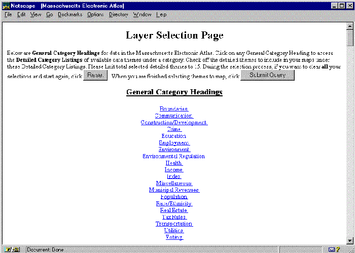
- Choose up to 15 data layers for display: From the Map Layer Selection Page, users can select data from a variety of general categories.
- Access the metadata for each layer: From the Map Layer Selection Page, the name of each data layer is a hyperlink to a metadata page describing the layer. This metadata describes the dataset, its completeness, currency of the data, and provides a contact or website of the agency providing the data. These metadata pages can also be accessed from the Map Browser page after the data layers for mapping have been chosen.
Map Browser Page
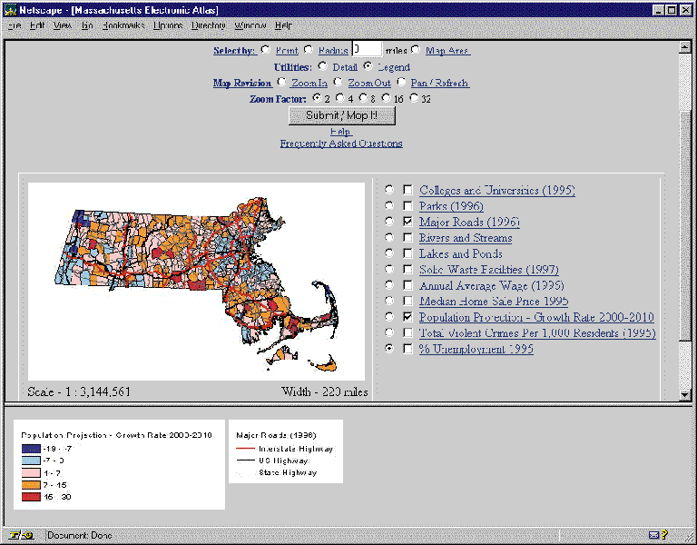
- Turn layers on and off: Users can display layers by checking the square boxes next to the layers they wish to draw. Clicking the Submit/Map It! button will redraw the map display with the new data layers.
- Zoom and Pan: The Map Revision section allows users to zoom and pan on the map. Users check the Pan, Zoom In or Zoom Out check box; choose a Zoom Factor of 2x, 4x, 8x, 16x, or 32x; and then click on the map to redraw and recenter the map on this point.
- Create a legend: From the Utilities section, users can request a legend by checking the legend box and then clicking on the map. The legend will be drawn in the lower frame.
- Query the active layer by point, radius, or map area : Under the Select By section, users can query the active layer by point, radius distance, or the entire map area. The active layer is denoted with the circular check box. The attribute data of all selected features will appear in the lower frame of the Map Browser.
- Create a detail map snapshot: A detailed "map snapshot" of an area of the map in the upper frame can be created in the lower frame. This allows users to view a detailed section of a map in the lower frame without changing the display in the upper frame.
Additional Functionality
- Access help and frequently asked questions: From the Map Browser Page, users can access hyperlinks to a detailed Help page and page of Frequently Asked Question. Each "Request" on the Map Browser Page is also a hyperlink to a short description of how to use that function.
- Select map size and data downloading options: Users can choose from creating a small, medium, or large map. Users can also choose to have attribute data displayed in a formatted HTML table or a comma delimited text table. By downloading the numeric data in comma delimited form, these data can be easily imported into other database management software for further analysis.
- Save the attribute data in the lower frame or save the map: Numeric data in the lower frame can be saved by saving the lower frame as text. The maps and legends can currently only be saved by saving the entire computer screen.
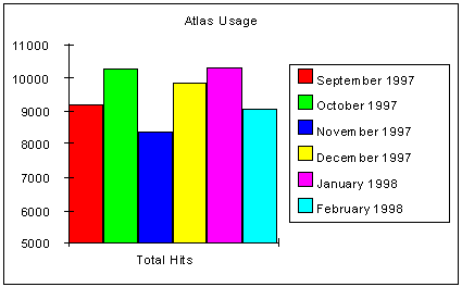
Atlas Usage
Use of the Massachusetts Electronic Atlas has totaled approximately 57,000 total hits and 4,800 unique users during the last 6 months. Categorical use of the data on the site has shown environment, crime, transportation, education, employment, and population to be the most highly used categories.
The potential uses for the Massachusetts Electronic Atlas are expected to be extensive and continue to expand. Although the atlas was first designed with a target audience of students and research scholars, a variety of business, local and state governments, nonprofits, and the public are using the atlas to evaluate their needs. For example, searches vary from property tax rates and home sale prices to elder health care needs and physical characteristics of the environment. Local town governments have already begun to use the atlas to gather data on ethnicity in terms of birth to predict changes in the school systems and to plan for future needs such as languages that may need to be taught. Many tourists and newcomers to the state are also likely to use this atlas to identify areas of interest for visiting or residence.
III. Future Directions
In the future, this atlas and others will continue to serve as extensions
to traditional map libraries. As Internet Mapping technology continues
to advance, avenues for disseminating and increasing access to spatial
data by novice uses will continue to improve. For example, in the next
version of our site, we will be using the improved IMS technology to 1)
add map downloading and printing options, 2) change to a more intuitive
Java based interface, 3) add interactive labeling, 4) support raster data
layers and larger vector files, and 4) possibly add interactive color and
range creation options to our thematic mapping layers.
By providing a "neutral site" for the collection and access to digital data for the state, libraries can continue to forge strategic partnerships and play a critical role in disseminating the increasing flood of digital information available. Through innovative Internet interfaces, users can now create maps that directly mirror their needs, rather than waiting for government agencies to print and distribute maps, libraries to acquire these maps, or spending time learning how to use often daunting stand-alone geographic information systems. The library collection of the future must continue to explore new mechanisms to allow users to access library resources "beyond library walls". As libraries accept these changing digital challenges, they will resist becoming "paper museums" and successfully continue to meet the needs of a diversity of map users.
David Cobb
Harvard Map Collection, Head
Harvard College Library
Cambridge, MA 02138
ph. 617-495-2417
fax. 617-496-0440
cobb@fas.harvard.edu.
Arlene Olivero
Harvard Map Collection, GIS Specialist
Harvard College Library
Cambridge, MA 02138
ph. 617-495-2417
fax. 617-496-0440
Arlene Olivero.