Salah Sadek and Mounia Bedran
An integrated GIS framework was developed as a decision-aid tool for a multi-criteria evaluation of route alignments. The framework integrates specialized slope stability and roadway design packages within the ArcView user friendly environment. The objective is to allow for multi-criteria analysis and evaluation of route alignments based on the integration of: topographic, geometric design, geologic and geotechnical slope stability analyses, environmental impact and community disruption evaluation.
In this paper, the methods adopted and devised for building such framework are discussed, with particular focus on the development environment, application infrastructure and integration of specifically developed codes in Avenue, SML and AutoLISP, along with specialty civil engineering software packages for cut and fill and slope stability analyses.
The use of GIS in civil engineering applications is on the rise. Engineers have come to value the relational capabilities and the potential of GIS in their respective disciplines and fields of specialty.
Many civil engineering applications involve data intensive exercises, based on geographical information that take the form of maps and aerial photographs. The civil engineer has to analyze the data in all its forms, often interpreting, linking and comparing various geographically referenced information as part of a design, or analysis task. These multi-criteria based designs and analyses are often time consuming and done on hard copy. GIS, with their spatial analysis capabilities, can make a difference by improving the methods used, and enhancing efficiency.
The task of designing or selecting the optimal route alignment for roadways and highways is a civil engineering application that can and should benefit from GIS. This engineering task is always complex and challenging: Tracing the final alignment for a roadway involves making decisions and assessments that are based on a large set of criteria, some complimentary and others competing.
In this paper we describe the integrated GIS framework which was developed as a decision-aid tool for siting roadways. Using Esri's ArcView (as the system engine), an integrated ArcView framework for roadway design, analysis and evaluation was developed and tested. The framework integrates and interfaces specialty-engineering software within the ArcView environment. In this paper we focus on the building of the framework and the development environment. The application infrastructure, and integration of the specifically developed codes in Avenue, SML and AutoLISP, along with existing widely used engineering software packages (AutoCIVIL by AutoDesk, and Slope Stability analysis software) are addressed in detail.
The data sources involved in the siting application are numerous and varied. Cadastral maps, topology maps, street maps, geology and soil maps, among others, are reviewed and combined at different scales. These sources of data have a common geographical reference, and are analyzed, interpreted and linked through the developed framework to provide the user with a set of pre-determined evaluation measures.
The framework developed uses ArcView 2.1 as the system engine. It interfaces with PC ARC/INFO 3.4.2 where some of the spatial analysis is performed. It integrates and interfaces a specialized roadway design package (AutoCIVIL by Research Engineers), and sets up the use of a specialized slope stability package when a more elaborate stability analysis is desired.
AutoCIVIL is a comprehensive civil engineering software package running within AutoCAD. Its AutoRoads module has the capabilities to analyze the roadway and calculate the volumetric quantities. The process includes vertical alignment, template design, and the calculation of cut and fill volumes. The AutoRoads outputs of interest are the cut and fill and mass-haul reports.
The slope stability package could be any commercially available or specifically developed package. XSTABL by Interactive Software was used as the preferred input file format.
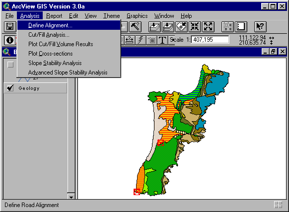
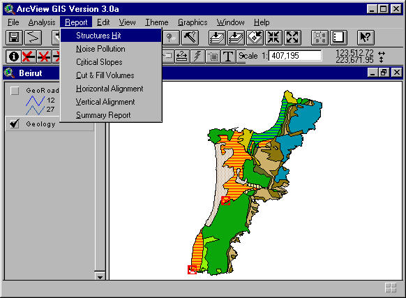
A customized ArcView menu-driven interface, tailored for this framework, is loaded as soon as the project is launched. The analysis functionalities are grouped in the "Analysis" Menu (Figure 1), while the Evaluation functionalities in the "Report" Menu (Figure 2).
The "Analysis" Menu contains six modules that go trough a step by step design and analysis of the user proposed road alignment.
The "Report" Menu contains seven functions that evaluate the proposed road alignment from the different aspect listed: environmental, geotechnical, geometric design, and report the results.
To interface all the used packages with ArcView keeping things transparent to the user, a multitude of customization languages had to be utilized. Coding specific to each package was used. Thus, the system is a mix of PC ARC/INFO 3.4.2 SML (Simple Macro Language), ArcView scripts, AutoCAD scripts as well as some AutoLISP functions.
Building the database is the most critical and time-consuming phase of the process. The quality of the analysis and its results is significantly affected by the quality of the database: is it comprehensive, complete and accurate? The database design is determined by the nature of the application and its objectives. This actually defines the study area boundary, the necessary coverages, the features required in each coverage, the attribute data needed for each feature type, and how to code and organize these attributes.
In the case of the application developed and described in this paper, the following minimum coverages are needed: Geology and Soil, Topography and Contour lines, and Existing Structures.
For the case of Lebanon, and in particular, the Beirut Metropolitan Region (BMR) in which the integrated GIS framework for road siting was tested, obtaining the necessary data and digitizing it was a very tedious and time consuming task.
This coverage is needed in order to provide guidance as to the materials that are to be excavated or filled over. This is an important aspect of the evaluation of road alignments that has important cost implications. The traditional practice is to address this aspect of the design only after a preliminary alignment is selected. The attributes necessary for this coverage, are the name and the geological reference of the various "polygons" along with an engineering evaluation as to their ease/difficulty of excavation and ability to support embankments (fill). For the case of Lebanon, for which the framework was tested, the geology map of Lebanon developed by Dubertret in 1955 was used. Since it contains both polygon features (the geology boundaries) and line features (the faults), this map was automated/modeled as 2 separate coverages:
Geology coverage (polygons) · Faults coverage (lines) Two different scales were adopted to automate the data. To obtain digital geology data for all Lebanon in an optimal time frame, the scale 1:200,000 was adopted, whereas a more detailed scale, 1:50000, was used for automating the BMR.
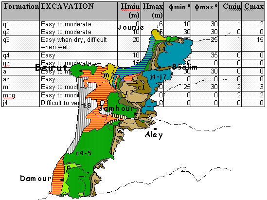
This coverage is used primarily in the slope stability evaluation phase within the GIS framework. All geotechnical analyses require a knowledge of such factors as the geological conditions of the soil under consideration, and the behavior and stress-related deformability of the soil that's being disturbed by man-made activities from its natural stable state. These can be translated quantitatively in terms of geotechnical properties, the most important being the soil unit weight (g) and its shear strength and deformation. Strength can be measured in terms of 2 soil parameters, cohesion (c), and angle of friction (f), the resistance to inter-particle slip. In this case geotechnical properties of unit weight, g, and shear strength parameters (cohesion, c and friction, f), are assigned as attributes to the various "soil" polygons. This is by no means an easy task. It relies on already existing data, but more fundamentally on a knowledge of the soil and geologic setting, and formation, along with engineering judgment. Such values can and should be updated and improved, as more data becomes available.
A topology contour lines coverage is very important in this case. The topography and natural contour of the terrain have a critical impact on the suitability and desirability of any proposed road alignment. They affect volumes of cut and fill necessary and vertical slopes among other evaluation criteria. The contour interval should be limited to practical values. For the work described in this paper contour intervals of 50m were selected, although the user could have opted to use 30 or 10m contours for example.
For Lebanon, the contour coverage was developed by Khatib & Alami. In the case of the contour line the scale 1:20,000 was adopted for digitizing the topology contour lines, resulting in 50-meter contour intervals.
This coverage is necessary in order to evaluate the environmental and community disruption impacts of the proposed road alignment on existing structures. These structures could be possibly "hit" by the alignment itself, or they could be within the zone affected by the noise and other environmental impacts of the proposed highway.
The Road Design Framework is implemented as a set of extra functions, which are integrated into the ArcView interface within the two customized menus shown in Figures 1 and 2. The next sections discuss each of these functions, its aim, structure and results.
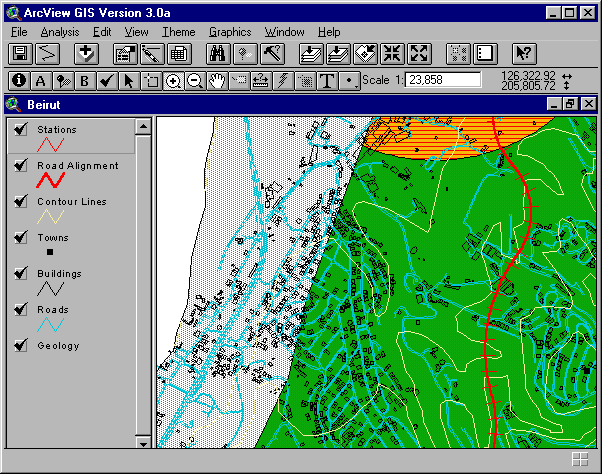
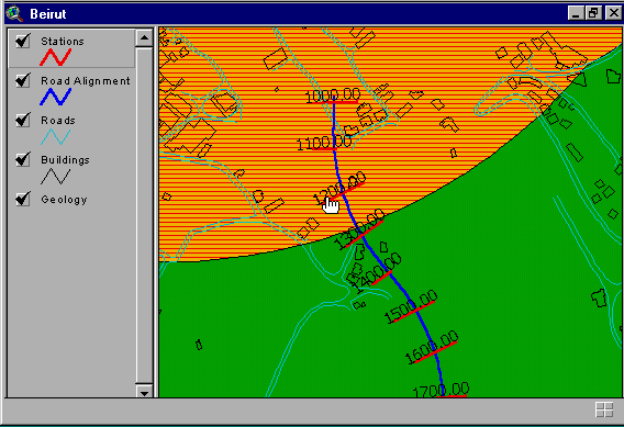
GIS advantages mostly show in this step of the road design, since the view combines most of the data needed in the decision making process (Figure 4). This function guides the user in defining a horizontal alignment, and then performs a spatial analysis to identify the underlying geology and soil formations.
The structure of this function is somehow complex because it requires extensive user interaction. In order to provide a robust application, this function is designed to expect any "unusual" response and deal with it, without abruptly terminating the application.
The first part of this function -defining the road alignment- is completely embedded in ArcView. A spatial intersection necessary to identify the underlying geology formations is performed, transparent to the user, using the PC ARC/INFO capabilities (Figure 5).

This function was developed to make use of the AutoRoads capabilities to calculate volumetric quantities of cut and fill. AutoLISP and AutoCAD scripts were developed to customize the functions within AutoCIVIL, and to exchange data between ArcView and AutoCIVIL.
The AutoRoads menu-driven interface was customized to respond to the needs set by this function: any end-user, unfamiliar with the AutoCIVIL or the AutoCAD environment, shall easily find his/her way to interactively define the road vertical alignment. The process of customizing AutoCIVIL turned out to be a very difficult task since the package is protected: the AutoCIVIL Lisp functions are in executable format, and there is no way to modify these functions or even find out their arguments. After many efforts and trials to overcome this handicap, the solution was to use the AutoCAD scripting programming interface.
Activating the "Cut and Fill Analysis" function will start a new session of AutoCIVIL, and launch the startup AutoCAD script which will setup the proper environment, and import the horizontal alignment previously defined by the user in ArcView. To efficiently make use of the memory storage and increase the speed of performance of the system, the Digital Terrain Model (DTM) of the BMR had to be divided into several files. Consequently, this script will build and assemble the required DTM files needed for the earthwork analysis of each defined alignment.
Using the customized interface, the user defines the desired geometric design criteria: template (Figure 6), horizontal curves, and vertical alignment. A sample quantities report generated is shown in Figure 6.
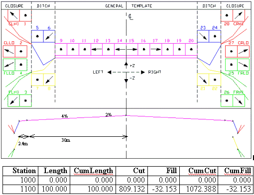
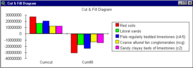
The aim of this function is to qualitatively interpret the technical data produced by AutoCIVIL, thus giving a new sense to the earthwork quantitative reports. This function translates the cut and fill reports (text file) in tabular dbf format readable in ArcView, interprets these reports by spatially combining them with the underlying geology, and finally creates a graphical representation of the results (Figure 7).
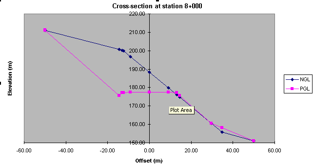
The power of this function lies in its friendly environment: the user points to a station on the view (Figure 8), and its cross-section chart will be plotted (Figure 9).
This is a somehow complex process, since the Natural and Proposed Ground Elevation (NGL and PGL) generated by AutoCIVIL are not only in text format, but they are not "compatible". Combining these two files into one table requires a linear interpolation since the offset values do not match.
This function checks the stability of the slopes of excavations and embankments induced by the cut and fill process. It loops over the left and right side of each station, identifies and calculates the different parameters involved in calculating the Factor of Safety: angle of excavation/embankment, height of excavation/embankment, underlying soil parameters, etc.
Different stability cases are considered in calculating the Factor of Safety, and the real complexity of this function is to determine which stability case to apply, and where. Relating cross-sectional elevations to underlying properties of the geology strata, cases are identified, critical Factors of Safety are highlighted on the view (Figure 10), and a stability report is generated. A typical slope stability report generated at each station is also shown in Figure 10.
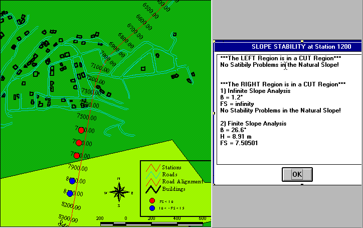
This function creates the adequate input files, at all identified critical sections, necessary for running the slope stability package (in our case the file format chosen corresponds to the XSTABL package). This step is very delicate in a sense that the input file creation is very sensitive: any unnecessary space and the running will not process correctly. To be able to run this package, the user has to be familiar with geotechnical engineering and analysis.
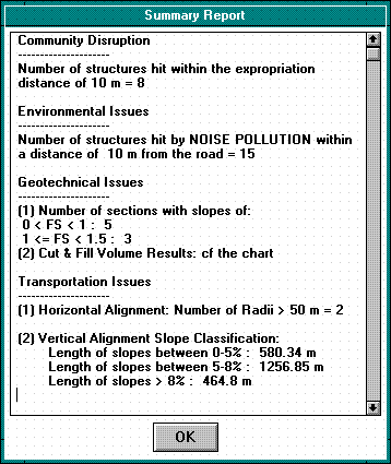
All functions within the "Report" Menu are completely embedded within ArcView and combine standard ArcView functionalities. Once the analysis is performed, all the data necessary for the running of these functions are already in ArcView format. At this stage, environmental, geotechnical and geometry assessments are only statistics! Using ArcView spatial analysis, assessments are performed and reported (Figure 11).
The reliance upon GIS based frameworks in order to expedite civil engineering application is in steadily becoming the norm rather than the exception. More importantly, this approach allows the user to gain more insight into the design process, and ask new and more probing questions.
The ability to integrate already existing and widely used civil engineering software within the GIS environment should make the transition a smoother and less painful process. The integrated framework described in this paper is a clear example of the potential in this field.
The type of application for which the approach described will work best, are applications that require the integration of a large number of data sources, and parameters into a decision/design process. The siting of roads and highways is such an application and the GIS framework made a great difference. Improvements are still possible and necessary.
Other civil engineering applications that could benefit from an approach similar to the one adopted in this paper are possibly: Identification of potential landfill sites and assessing their environmental impact, Identification of potential quarry sites and assessing their environmental impact, Mapping areas of high soil earthquake related hazards, etc.
The support of the University Research Board of the American University of Beirut is sincerely acknowledged, along with the technical assistance and support of Khatib & Alami, Consolidated Engineering Company.
Bedran, M., "A Geographically Referenced Model of the Beirut Metropolitan Region (BMR) Incorporating Pertinent Geotechnical Properties", AUB 1997.
Walley. C.D., "The Stratigraphy and Geological History of Lebanon: an Outline", AUB 1996.
Zura, M. and Lipar, P., "The Road and Traffic Environmental Impact Assessment and Optimal Room Layout Selection", Proceedings of the Fifteenth Annual Esri User Conference.
Salah Sadek
Assistant Professor
Civil and Environmental Engineering Department, American University of Beirut
Mounia Bedran
Civil Engineer- GIS Analyst, Khatib & Alami