QuickView for PALS:
A Map Objects Application with Links to ArcView
Pierce County’s Planning & Land Services’ (PALS) counter personnel use geographic data on a daily basis to serve the public in the permitting process. QuickView for PALS was designed to speed the lookup of this GIS data right at the counter reducing the need for manual search for data and data sources. QuickView for PALS was developed in PowerBuilder with embedded MapObjects controls. This interface allows counter personnel to quickly look up and perform their most common map and database queries, previously done by hand, involving multiple map and database sources, in a timely manner. Rather than re-implementing previously developed tools provided by CountyView, a county-wide ArcView application, which allows for easy access to more than 150 themes of county GIS data, the PALS Permit Counter System allows for integrated access to CountyView from within the application. This is extremely useful for checking GIS data on an ad hoc basis for individual requests at the PALS counter. Geocoding is also done through CountyView. ArcView uses a more robust geocoding implementation allowing for a higher percentage match rate of the many unusual Pierce County types of addresses. Discussion will center around the use and development of the system and some of the technical details.
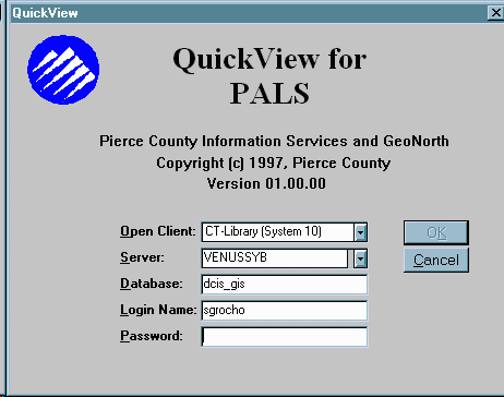
Figure 1
QuickView was developed for the Planning and Land Services (PALS) counter personnel, most of whom have had no contact with GIS prior to being trained to use this application. It was made for the "new generation" of GIS users who have for the most part never even heard of that letter combination before. Therefore it needed be easy to use and look familiar to those using it. That type of look and feel is what MapObjects does so well for applications with a GIS component in them. The only thing the user sees differently from the other applications is the fact that they can see a map. PowerBuilder, VisualBasic or other windows based interface designers, is well suited for creating applications with a consistent look and feel. Pierce County has developed a set of standards for PowerBuilder design along with a set objects available to all application developers to use, in order to maintain a common look and feel to a wide range of applications. MapObjects merely provides additional classes of objects available to the developer for use with GIS components. QuickView does display a map but its real function is to return in table format GIS data extracted using the common GIS concepts of location and proximity.
The PALS counter already uses an application to derive information about active and past building permits and this application serves it purpose well but it cannot find by itself other spatially associated data for a particular permit or parcel. QuickView is designed to fill in those holes. A User of the system logs into the database using the same login and password used to gain access to the existing system. Once logged in the user sees a screen with two blank tables some line input fields for searching and a map of Pierce County showing Cities and major roads. This window contain two tabs a Search tab and a Details tab. By default it opens to the Search tab.
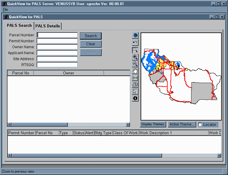
Figure 2
The Search tab allows for searches to be done on currently active permits and the associated parcels. Searches can be performed from Parcel Number, Permit Number, Owner Name, Applicant Name, Site Address and Quarter Section number. The Owner Name, Applicant Name and Address search fields can be filled with only partial information supplied, i.e. entering "w" in Owner Name will return all the names beginning with "w". Combinations of fields can also be used for searching such as all the Names beginning with "b" in Quarter Section 0318111. Once the search is entered the two data windows are populated with all the appropriately matching data. By default the first row is selected and the lower Permit data window is populated with active permits to that parcel and the map zooms to the location of and shades in the selected parcel. The data window column heading provides sort capability for the column clicked on. This is a common feature seen in most Pierce County applications.

Figure 3

Figure 4
Once located on the selected parcel the user can interact with the map in various ways. There is a set of buttons down the left side of the map. This map Tool Bar is very similar to the Tool Bar available in ArcView. As discussed below Pierce County uses a customized ArcView application called CountyView a generic GIS data viewer. Therefore those using QuickView who have also used CountyView will have no problem interacting with the tools and map in QuickView. The tools as shown below include many common GIS map tools, such as zoom in and out, pan, measure and identify. One of the useful additional tools is a maptips tool which allows the user to return information about a particular feature on the map by merely passing the cursor over that feature. This is much like what is commonly seen with buttons on windows applications.
Figure 5
Other map interaction tools include a popup menu for displaying additional layers of GIS data on the map an Active Themes button for choosing which theme will display with the identify button and a Locator Switch for changing the display of the map from being zoomed-in to the selected parcel to an overview of the County with a red box display where the current map extent is within the county.

Figure 6
A second tab for QuickView holds the real value of this application, this is the Details tab. Upon clicking the Details tab three new data windows are displayed along with the map of the selected parcel with two new sets of buttons. The new data windows are populated based upon the location of the selected parcel. These data windows return only GIS data all of which are maintained as shapefiles in the GIS database. The uppermost data window is labeled General Information and contains GIS data available for the location of the selected parcel. This is locational data which exists for the same geographic location as the parcel. Included here are city, fire district, school district, Indian reservation, Urban Growth area, zoning, frost depth, snow load and wind speed. The lower two data windows contain proximity data, such as nearest road and some of its attributes, sewer line, flood zone, volcanic hazard and wetland. All of this data previously had to be ascertained from hard copy maps most of which needed to be pulled from a map case after at another location. Now the counter person has the data at hand almost immediately. There is also a parcel navigation tool included with this tab. This tool allows the user to navigate the list of parcels returned from the search without returning to the search tab.

Figure 7
The final button is the CountyView button which allows the user access to Pierce County’s GIS browser. This feature exists because not all GIS data is available through QuickView but it is available in CountyView. Where fifteen themes are currently accessible to QuickView, CountyView allow access to over 195 themes of data. Therefore when further research is required to service the customer with his request a click of the CountyView button will start CountyView and pass to it the extent of the map display and the selected parcel using Dynamic Data Exchange (DDE). With this information CountyView can zoom to and display the selected parcel just as it appears for the user in QuickView. Once there all the county’s GIS data and all the functionality of CountyView and ArcView is available to the user.

Figure 8
A second way to access CountyView is through the search tab. When a parcel number is selected from the PALS permit database which is no longer a good or existing parcel number in the Assessor-Treasurer (ATR) parcel database then a message box appears stating that the Parcel Number is not found but would you like to try an geocode the address and find the parcel that way. If the user answers yes then the address is passed to CountyView along with the Parcel Number and CountyView attempts to geocode that address. MapObjects is capable, of course, of doing geocoding itself. However we have found that because of the many address idiosyncrasies within Pierce County, for which the GIS department has previously written special geocoding rules within CountyView, CountyView does a much better job of getting correct matches on most addresses. When a match is found in CountyView the user, with the help of a customized tool on the CountyView tool bar  , can poke around at the surrounding parcels in hopes of finding the one in question. This is necessary since the geocoding is done to the street segment not the parcel itself. Good address information for each parcel is not yet available to GIS because of quality concerns from the ATR parcel database. Though we hope to have good parcel addresses soon, presently geocoding must be done on the street segment level. From this street segment address we can get close to the parcel in question but using the <insert glasses button> tool is necessary to locate the exact parcel. The tool when used on a particular parcel will return a message box giving the original search address and the parcel number, owner name and delivery address for that parcel. Usually that information is sufficient to identify whether or not it is the parcel being searched for. When the question "Is this the parcel you are searching for is answered with a yes. The display returns to QuickView and populates the Details tab for the returned parcel.

Figure 9
This method of search also allows the QuickView user to find any parcel in the County and return its QuickView detailed information. CountyView has many methods which can locate parcels by name or number and these functions can be used to find parcels not yet in the permit database, but are required for QuickView searches. After locating a parcel the tool can be used to locate the same parcel in QuickView and return its detailed information.
A final feature of QuickView is its reporting capabilities. Once the details data windows have been populated a report can be produced showing all the detailed information along with permit and parcel data and the zoomed in display of the parcel itself. Also included is an overview map and an attractive page layout.
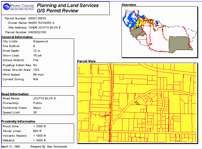
Figure 10
Technical Notes
The GIS data for QuickView resides on a UNIX server. This GIS data is the same source for both CountyView and QuickView. However one of the advantages of using PowerBuilder and MapObjects to access the data is that they can use the Universal Naming Convention (UNC) to locate the network source of the data. ArcView does not handle the UNC designation well and requires either hard coded drive mappings or system variables to locate the network source.
QuickView was designed to run on a Pentium 166 megahertz chip machine with a minimum of 32 megabytes of memory. Machines of this size or better were purchased for use by PALS personnel. Machines with less than these minimum standards have been found to be maddeningly slow especially when running both QuickView and CountyView simultaneously. QuickView was also designed to run on either Win95 or WinNt machines. A bug was found in Win95 during the testing process which would color the screen in a solid color if the zoom-in exceeded a certain factor. WinNt had no similar problem. The dynamic data exchange (DDE) connections were also more quirky under Win95. Code needed to be written especially for the Win95 installations to allow for a second try of establishing a DDE connection to ArcView in some cases.
MapObjects had some problems drawing large complex polygons. The Pierce County cities shapefile was an example of this. The unincorporated sections of the county are large polygons enclosed by polylines with many vertices because of the county boundaries following rivers and the Puget Sound. This problem was alleviated by creating a polygon shapefile containing just the cities, another with only Puget Sound, which was subdivided into six polygons, then adding a separate line shapefile for the county outline. These changes significantly improved drawing speed especially when zoomed into areas of the unincorporated county.
Another problem encountered in using MapObjects was its lack of ability to use ArcView attribute indexes on shapefiles. The only way to add an attribute index was to use the index in the PlaceLocator Object, however this allows for only one field per shapefile to be indexed and can take hours to build. In order to optimize parcel number searches this indexing procedure was determined to take too long, 5 or 6 hours on even the fastest UNIX boxes, to build over the 250,000 row parcel shapefile, a shapefile which is updated on a regular basis. Therefore a solution was developed which creates a table of the center point x and y coordinates of the each parcel polygon in the PALS Sybase database. Quick searches of that table could be accomplished using SQL to return the x and y coordinates of the parcel center. Then the MapObjects SearchByDistance Method was used to find the polygon which contains that point. The table of center points is created as part of the parcel shapefile update process and is easily generated from the parcel polygon shapefile. This method returns the parcel quickly and efficiently without having to use an attribute index. However we do hope to see attribute indexes for shapefiles within MapObjects in the future.
Acknowledgments:
I want to acknowledge the hard work and dedication put in by many different people to make this application work. Mark Budai of GeoNorth Inc. whose expertise in PowerBuilder and MapObjects provided the basis for this application. Also for Raymond Odem of Pierce County Software Development Group who assisted in making QuickView work as a Pierce County application. Also to my GIS co-workers who provide the support and guidance that only other GISers can Chuck Buzzard, Stan Gerber, Dan King. And of course Linda Gerull without whose vision none of this "GIS stuff" would ever happen at Pierce County.