ABSTRACT
The study aims to analyze the effects of the Birecik Dam, which is
being constructed on Firat (Euphrates) river in the scope of the SouthEastern
Anatolia Project (GAP), in TURKIYE, on the reservoir area. GAP is now one
of the most ambitious regional development projects ever attempted in the
world. It covers, in addition to the irrigation and hydropower schemes,
all the related social and economic sectors including industry, transportation,
mining, telecommunications, health, education, tourism, and infrastructure.
There are 29 sub-projects under the GAP, developed through the cooperation
of the GAP (RDA) Regional Development Administration
and the United Nations Development Program (UNDP). One of these 29 projects
has the title "Assistance to Rural-Urban Integration in Halfeti, Sanliurfa
and Community Development Programs". In the scope of this project this
study is an important part which will delineate the agricultural and residential
areas that will be flooded and find out the owners and site selection for
re-settlement. It will include the delineation of the settlements, vegetation,
roads , water transmission canals, energy transmission lines , etc. that
will be under the reservoir lake and to select a new site that will satisfy
the needs of the people living at those area. Geographical Information
Systems and Remote Sensing techniques are used in the study.
GAP is now one of the most ambitious regional development projects ever attempted in the world. It covers, in addition to the irrigation and hydropower schemes, all the related social and economic sectors including industry, transportation, mining, telecommunications, health, education, tourism, and infrastructure. There are 29 sub-projects under the GAP, developed through the cooperation of the GAP Regional Development Administration and the United Nations Development Program (UNDP).
One of these 29 projects has the title "Assistance to Rural-Urban Integration
in Halfeti, Sanliurfa and Community Development Programs". The scope of
the work for this project comprises the following tasks. The tasks are
: 1)Investigation of the urban structure and probable development areas,
2) Defining the socio-economis structure for the urban development strategy,
3) Development of master and implementation plans, 4) Delineation of the
settlements, infrastructure, buildings, agricultural areas that will be
flooded by the Birecik dam reservoir and site selection for re-settlement,
5) Development of master and implementation plans for urban physical infrastructure
of new settlements, 6) Development of a financial plan.
The project is conducted with a multi-disciplinary group consisting
sociologists, economists, urban planners, geologists, agricultural engineers,
surveyors, cartographers, and GIS specialists.
As a consequence of the construction of Birecik Dam which will produce
2 516 GWh electrical energy in the scope of GAP Project, 38 villages will
be flooded by the reservoir. The goal is to find out how much agricultural
and residential area will be flooded and the owners and site selection
for re-settlement. The project is presently in implementation under the
steering of a group of GAP consultants in line with the principles of sustainable
development and participation.
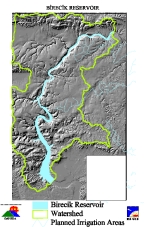
Project area covers 38 villages and approximately 30 000 population
of Birecik, Halfeti, Bozova, Nizip, Yavuzeli, Araban, Besni and Adiyaman
towns which is approximately 1200 km2 (1.6 % of the total GAP area).
After the conceptual design and development strategy completed by the
consultants, the database, staff resources and equipment resources are
designed. The data conversion and automation phase involved the incorporation
of map and attribute data from the original source maps into digital files.
The GIS data structure consists of 18 layers which are listed below:
· Elevation data from 1: 25 000 scale maps
· Slope
· Aspect
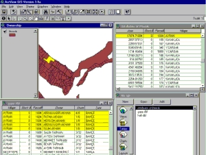
· Land records(parcels linked ownership, approximately 6000 records)
for 38 villages from 1: 5000 scale maps
· Administrative boundaries( including village, town, city, regional
limits)
· Land use ( determined using Remote Sensing techniques)
· Hydrology
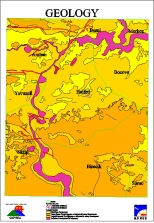
· Geology from 1 : 50 000 scale maps
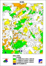
· Soil maps from 1: 100 000 scale maps
· Historical and cultural assets
· Energy transmission lines
· Irrigation facilities
· Transportation network (including railways and highways)
· Oil transmission lines
· Telecommunication lines
Using the above data the analysis described below are done :
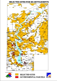
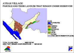
· The parcels that will remain under the lake are determined
· Site selection for re-settlements are done
· An application program is developed to execute the above analyses
for any required user-defined parameters.
METHODOLOGY
The project consists of two main analysis. For the first one, delineating the parcels which are within (pass through) the reservoir lake, the title information is linked to digitized parcels. The reservoir (lake) boundary is determined using related grid analyses. Then the parcels are overlaid with the lake boundary and the parcels within the lake area are determined. Statistical analyses are made and the amount of economic loss is calculated.
In the second analysis, site selection of re-settlements, buffer zones are created from the data ; fault lines, historical and cultural assets, energy transmission lines, oil transmission lines, reservoir boundary for protection purposes.
The coverages , slope, aspect, administrative boundaries, geology,
soil, hydrology, landuse are overlaid and a unique coverage is created
and then this coverage is erased with the buffer coverage. After a final
coverage is created for logical selection, areas for new settlements can
be delineated by user-defined parameters. An application program is developed
for this purpose.
The project is conducted in cooperation with the GAP RDA GIS group.
The computer hardware and software consists of ArcInfo and Arcview on
Sun Sparcstation 20, Arcview 3.0 on personal computers, HP 650c plotter,
scanner, and digitizing board.
|
|
|
|
|
|
Ahmet TUMAY
GIS SPECIALIST
RS GIS LTD.CO.
ZIYABEY CAD.56/11 BALGAT-ANKARA-TURKEY
tel: +90 532 354 11 63 , +90 312 284 00 24
e mail : atumay@usa.net
Ali Fuat CETIN
GIS SPECIALIST
RS GIS LTD.CO.
ZIYABEY CAD.56/11 BALGAT-ANKARA-TURKEY
tel: +90 532 354 11 63 , +90 312 284 00 24
e mail : alifuatcetin@usa.net
Ekrem OZDEGIRMENCI
GIS Personnel
GAP Regional Development Administration
UGUR MUMCU'NUN SOKAGI NO : 59 G.O.P. 06700 ANKARA-TURKEY
tel: + 90 312 446 76 56
Gamze ARICAN
GIS Personnel
GAP Regional Development Administration
UGUR MUMCU'NUN SOKAGI NO : 59 G.O.P. 06700 ANKARA-TURKEY
tel: + 90 312 446 76 56
Ilker ALAN
GIS Personnel
GAP Regional Development Administration
UGUR MUMCU'NUN SOKAGI NO : 59 G.O.P. 06700 ANKARA-TURKEY
tel: + 90 312 446 76 56