
Jules Loweff
Abstract
Increasingly, both GIS and transportation modeling packages are being used together to help develop multi-modal transportation programs. While most modeling packages continue to be used for network simulation and analysis, GIS has found a place in data preparation, visualization and further analysis. By combining the strengths of both systems, a more flexible and powerful modeling environment is created, along with an interface that facilitates user friendly visualization. The Long Island Transportation Plan to Manage Congestion, being conducted by Parsons Brinckerhoff, Inc. under the direction of the New York State Department of Transportation (NYSDOT), is an example of such an effort.
The LITP2000 study will provide an integrated multi-modal transportation program for managing congestion on the State Highway system and on selected local roadways within Nassau and Suffolk Counties in New York State. The first phase includes development of procedures for assessing the effects of alternative transportation system improvements and multi-modal strategies on existing and forecast highway congestion and mobility. These procedures include HOV and transit demand estimation, and traffic forecasting, as well as a process for utilizing the results from the TRANPLAN, TransCAD, and INTEGRATION models for the evaluation of alternative solutions. Performance measures are being computed for each of the alternatives and include air quality emission burdens. A GIS is being used to store transit route and highway segment attributes, origin/destination survey data, socio-economic data, and roadway attributes. An ArcView application will provide the interface between the modeling tools and ArcInfo GIS.
A unique feature of this application is the ability to combine the link/node performance measure output from the modeling runs with the route system/milepost information (such as roadway physical characteristics, posted speeds, capacities, traffic signals, transit routes, etc.) from the Arc/lnfo GIS environment. Programs are being written to automatically convert model performance measure outputs to route system locations that can then be combined with State Highway data for display and analysis.
Some of the functionality highlighted in this application are the integration of model output with Arc/lnfo and ArcView, the use of ArcView and its Dialog Designer extension for user interface development, and the use of Remote Procedure Calls to integrate specialized UNIX based ArcInfo routines with ArcView.
Introduction
The LITP2000 study is a major regional transportation planning initiative intended to shape future transportation policy and planning for Nassau and Suffolk Counties on Long Island. Parsons Brinckerhoff Inc. (
www.pbworld.com ) is conducting this study under the direction of the New York State Department of Transportation (NYSDOT). The project team is currently identifying existing and future deficiencies in transportation system capacity and travel mobility for both people and goods. The goal is to develop a staged plan of short-range and long-term actions to implement solutions to the identified deficiencies. When completed, LITP2000 will provide an island-wide plan for an integrated, multimodal transportation program that manages congestion on the state highway system and selected local system roadways. It will emphasize Travel Demand Management (TDM), Transportation Systems Management (TSM), and public and alternate transit solutions as complements to traditional highway capacity improvements. The Study includes the following:
The LITP 2000 Study also focuses on identifying mobility actions that can be implemented quickly and have a high probability of success. Among other measures, the following will be considered:
The Study will provide valuable and useful tools for the NYSDOT to utilize on its own, as well. It will provide procedures for assessing the effects of alternative highway improvement scenarios and multimodal strategies on congestion and mobility. Among others, these procedures will include High Occupancy Vehicle (HOV) and transit demand estimation, traffic forecasting, as well as a process for utilizing the results from the TRANPLAN, TransCAD and INTEGRATION models in an ArcView GIS environment for the evaluation of alternative solutions.
We chose to base the modeling effort on existing projects and environments rather that start at the beginning. As such, TransCAD is used by the Metropolitan Transit Authority (MTA) and the New York Metropolitan Transportation Coordinating Council (NYMTC) uses TRANPLAN and TransCAD for network modeling. We are using the networks developed by these others as a base. The INTEGRATION model performs dynamic simulation of highway networks. The initial INTEGRATION model calibration is at the areawide planning level, and provides the base for additional individual operational analysis. Corridor studies are providing additional detail for the subsequent operational analysis. The LITP2000 network has been created with 23,000 roadway links.
For the LITP study, data conversion, importing, and display of the modeling output for base year 1995, and "No-Build" 2020, as well as various build scenario runs are critical functions of the GIS. This process and the degree of its automation are the subject of the GIS effort.
A public participation program was developed early in the project. This program was designed to conform to the letter and spirit of ISTEA and MIS requirements. The requirements prescribe early and continuing proactive public outreach, including the provision of complete information and timely public notice to the broadest possible audience. The participation measures employed include: developing an overall program identity, technical advisory committees and sub-committees, newsletters, a print media program, a broadcast media program, telephone hotline, Internet Web Site, (
www.litp2000.com) an Electronic town meeting and other outreach activities, workshops, and meetings. Various GIS maps have been produced for display at the public meetings. While the LITP2000 Public Participation Program is consistent with ISTEA, its scope greatly exceeds Major Investment Study (MIS) requirements.A general review of the steps involved in supporting the LITP2000 study follows.
1 - GATHER/EVALUATE EXISTING INFORMATION
This initial technical task has been directed towards the assembly, review, and assessment of the current policies, plans, goals and objectives of relevant agencies and transportation providers on Long Island, as well as the assembly and evaluation of available demographic, socio-economic and travel data, trends, and projections. These are being reviewed to identify their status and most likely future "no-build" condition; to assess the potential effects of the policies and plans on the existing and future transportation systems; and their compatibility with the capacity/mobility goals and objectives of the NYSDOT.
The following is a description of the major geographic and attribute data items included in the study and available through the GIS interface:
Significant Project Locations:
Identifies significant development locations in Nassau and Suffolk counties. Location, type, and size identify each location. Data includes projects proposed, projected, or under construction within the primary and secondary study areas. There are 117 significant development projects, at 83 locations currently under construction or proposed and anticipated to be constructed.
Major Travel Generators:
Identifies the top 32 trip generators in Nassau and Suffolk counties. Location, number of trips in both 1980 and 1990, and travel mode for each trip identify each generator.
Origin-Destination Survey Results:
Using O-D survey data collected during prior studies, the major trip destinations and their origins are displayed by zipcode. Destinations are shown for both the AM and PM time periods. Additional O-D data generated from the modeling effort by TAZ is also converted from TRANPLAN and INTEGRATION format and plotted. Various GIS plots were produced with this data. Custom "spider" diagram Avenue Scripts were written to plot this O-D data in ArcView.
Intersection Capacity Analysis:
Ramp intersections within the study corridor were analyzed. Level of Service (LOS) and capacity levels were posted for both operational and planning analysis. The GIS is capable of displaying LOS, average delay, and approach delays. Using analyses procedures described in the Highway Capacity Manual (HCM); signalized and unsignalized capacity analyses were performed to determine prevailing levels of service at ramp intersections and arterial roadways along selected corridors. At certain signalized intersections representing ramp junctions, HCM operational LOS analyses were performed to determine existing operating conditions in detail, while the planning method was employed for the arterial intersections, as well as for the signalized ramp junctions along the north-south parkways and expressways.
Aerial - Arterial Congestion Study:
Identifies congestion locations along major arterials within the study corridor. Congestion levels were identified using aerial photographs. In the Spring of 1996, Skycomp, Inc. conducted an aerial photo-density survey of the expressways and parkways of Nassau and Western Suffolk counties. The purpose was to quantify traffic quality over all selected links of this regional highway system throughout the morning and evening peak periods of commuter travel. The information is used to support long range planning activities to optimize movement on Long Island. In addition, with this quantitative study of traffic quality on the freeway network, Skycomp conducted a qualitative assessment of traffic congestion on the arterial highway system, which comprised selected state highways with signalized intersections. Information about congested flow on the freeway system from this survey has been added to the arterial report to provide a balanced view of daily commuter congestion. Level of service ratings from A (light traffic) to F (congested traffic flows) were recorded. ArcInfo coverages representing congestion locations were created and plotted along with event data describing travel time and delay runs. Output from these reports, in the form of Postscript files, is made available in the ArcView LITP application for display.
ECO Data:
The Nassau and Suffolk Counties Employee Commute Options Data provided information on:
1990 Census Bureau Journey-To-Work data provides:
Various GIS plots were produced with this data. Custom "spider" diagram Avenue Scripts were written to plot this O-D data in ArcView.
2 - ESTABLISH THE EXISTING AND FUTURE YEARS TRANSPORTATION FACILITIES NETWORK DATABASE
Long Island's existing transportation system is comprised of several modes. The purpose of this step was to identify, define, and develop a database for multi-modal transportation facility and service planning, including establishment of a comprehensive baseline GIS transportation network. The initial roadway system includes, but is not limited to, highways on Long Island designated as a part of the National Highway System, other principal and major arterials, and local roadways of importance to the mobility of the region.
LITP Roadway Network and Database
A comprehensive database, which describes the physical and usage characteristics of the defined highway system, has been developed. The primary resources for this effort included: the most recent GIS based highway database being developed as a part of other corridor studies; the latest available Highway Sufficiency Rating Report by the NYSDOT; similar highway and transit GISs and databases from Nassau and Suffolk Counties, towns and villages of Long Island, as well as NYCDOT and MTA Bridges and Tunnels; the NYSDOT highway corridor development project reports; and the NYMTC Travel Demand Modeling Project.
The base map source is the New York State DOT County Base Mapping GIS Files. An understanding of this source is important for understanding much of the effort needed to create the modeling/GIS interface.
The NYSDOT Mapping and GIS Bureau (MAGIS) has provided an environment for all GIS users to show and analyze highway attributes on route systems. The New York State DOT's County Base Map Files cover whole counties and are separated into a number of themes. In addition to a local roads file, a Statewide Primary Roads file exists that has been created as ArcInfo dynamic segmentation route systems. A number of route subclasses exist for this layer. These include subclasses for roads maintained by NY State, the Thruway authority, and other jurisdictions. The State is also developing a Local Highway route System (LHRS) in GIS that will contain all locally owned Federal-Aid eligible roads in the state. Once completed, the LHRS will be used to produce new functional class maps and serve many GIS applications on important off-state roads (such as congestion management and transit system applications). The mapping and GIS section has built a statewide reference marker route system in 1996 for use with the NYSDOT's Statewide Primary Roads file. The route system displays the most current reference marker locations along state highways. A wide variety of NYSDOT data is collected based on reference markers including accident locations and various field surveys.
The State DOT Traffic Volume Report collects, summarizes, and interprets information on traffic volumes on the State's highway system. Data is annual average daily traffic for various traffic control sections. These sections are portions of a route system with beginning and ending mile point and reference marker locations. The NYS DOT also annually conducts a highway condition survey. The purpose is to determine the surface condition for each section of highway on both the NY State Touring Route and Thruway systems and the overall surface condition of these systems. Data is recorded based on route, control segment, county references, and milepost. Physical characteristics contained in this database include the number of travel lanes, shoulder width and type, pavement width and characteristics, and access control. Functional classifications and highway control codes are also included. Traffic information include annual average daily traffic volumes, design hour volumes, capacity, volume/capacity ratios
Route Development:
Much of the state highway related data is available in a milepost format. Route systems that allow a geographic link to this information were developed. It encompasses roads within the LITP modeling network, which will also have attached data, and is available in a GIS format. Developed criteria for selecting network roadways include: expressways, parkways, arterials with 4 or more lanes, arterials providing access to interchanges, and selected collector roads. We cleaned the network in terms of travel direction and node intersections. Roadway link attributes such as number of lanes and traffic volumes were added. Many of these attributes were first coded on to ArcInfo route systems and then transferred to TransCAD. See the discussion below for more information on issues relating to route network development.
Roadway Attributes:
The roadway attributes of major importance include those relating to connectivity and continuity of the network and other link attributes (i.e., highway/street names, travel directions, number of travel lanes by direction, posted speed limit, and highway functional class). In general the roadway information collected includes the following:
LITP Public Transportation System Network and Attributes
A network of existing public transportation systems on Long Island has been compiled as well. This includes: Long Island Railroad (LIRR), Long Island Bus system, Suffolk County Transit, HART, Long Beach Transit ferry service, and vehicles-for-hire. This study network has been created as a TransCAD database for modeling purposes. At the same time many of these networks exist as ArcInfo based systems. There have been extensive conversions between these two environments. In many instances ArcInfo was used for re-formatting and editing of the data prior to conversion. Both ArcInfo and ARC/VIEW are used for GIS data management analysis and display.
While most of the data described above are available from existing sources, the magnitude of the data and the varying formats used by different agencies/projects is likely to hinder its usefulness unless reorganized and streamlined. A user-friendly GIS application for multi-modal transportation system information storage, retrieval, and illustration is, therefore, being developed. When completed, the GIS based, multi-modal transportation application will provide the NYSDOT with an efficient and user-friendly storage, retrieval, maintenance, and updating system for the extensive transportation facility and usage data. The GIS system will be able to utilize ArcInfo, ARC/VIEW and TransCAD.
Training to NYSDOT Personnel
Once the system is developed, a significant part of this study is the provision of training to NYSDOT GIS/Database personnel on the database structure, the use of the TransCAD modeling platform and the ArcView GIS interface. NYSDOT modeling staff will be trained on the procedures developed to simulate the multi-modal network and travel demand/trip assignment process, as well.
3 - DEFINE MULTI-MODAL NETWORK ANALYSIS PROCEDURES
After base information was collected the analysis needs of the project needed to be addressed. These procedures were specifically related to the performance measures and evaluation criteria established for the study goals and objectives. The purpose was to: (1) develop a comprehensive reference base for the existing multi-modal transportation system and service conditions; (2) identify and define the deficiencies of the system in meeting existing and future personal mobility, goods movement, and air quality conformity objectives; and (3) identify, develop and evaluate the most viable multi-modal transportation programs and strategies to mitigate existing and future deficiencies and provide the most effective use of limited resources.
In order to meet the analysis needs in efficient and expeditious way, We have developed a tiered analysis procedure. The first tier represents the more expeditious analysis procedure designed to analyze a large number of conditions, alternatives, and strategies in a less detailed (i.e., more aggregate) manner. This procedure involves the conventional four steps of transportation planning - trip generation, trip distribution, mode choice, and trip assignment. The TRANPLAN model is used for highway network analyses while the TransCAD model is used for public transportation network analyses. The purpose of the second tier analysis is to overcome the limitations of the "static" trip assignments employed by the conventional travel demand model (e.g., TRANPLAN, MINUTP).
The GIS system developed in the steps above will be used to present and communicate the results of the analysis (e.g., existing and future traffic conditions) to the NYSDOT as well as to the public.
Study area and transportation network:
The study areas, traffic analysis zone (TAZ) structures, and transportation network structures were defined and developed in consultation with the NYSDOT. The regional transportation network being developed by the New York Metropolitan Transportation Coordinating Council (NYMTC) will be used as the basis in the first-tier analysis. This network was further refined for the second-tier analysis approach, using the more detailed Long Island highway network developed by recent NYSDOT corridor studies (e.g., Southern State Parkway Corridor Study, Northern State Parkway Study, etc.).
Trip generation and trip tables:
The trip generation task was performed to establish zonal person trips. The person trip tables were developed to represent a minimum of three trip purposes: home-based work, home-based other, and non-home based. The trip tables were structured to represent varying travel patterns and compositions during three different average weekday time periods, AM peak, PM peak, and midday.
4 - DEFINE EXISTING (Base Year) AND FUTURE "no-build" TRANSPORTATION SYSTEM CHARACTERISTICS
Employing the comprehensive transportation system database and an integrated analysis procedure, we next assessed the existing and future multi-modal transportation system performance characteristics and identified deficiencies. At the outset of this task, a comprehensive set of performance measures and evaluation criteria were developed. These provided a common basis for evaluating multi-modal transportation system performance. An integrated multi-modal transportation system analysis model was developed and calibrated as well. Both the performance characteristics of the existing transportation systems as well as the future "No-Build" programs, policies, and strategies were assessed.
A major component of this process is to establish specific performance measures, evaluation criteria and targets for achievement that are consistent with broader policy goals. These will form the basis in
The goal of the LITP ArcView application is to be able to present a user with the ability to display the above performance measures for the various alternatives and scenarios resulting from the modeling runs.
The major steps involved in this task, along with the significant GIS inputs are as follows:
The transportation needs and demands of the region include two broad categories: person trips made by various travel modes and commercial trips made to satisfy the needs of goods movement. In this step, the base year demand of these trips in terms of zonal trip production/attraction and geographical distribution (i.e., origin-destination trip tables) has been established. Separate trip generation/trip distribution data have been developed for person trips and to the extent that existing information permits, goods movement related trips, respectively.
The trip tables have been developed to represent at least three distinct time periods: AM peak period, PM peak period, and off-peak periods. The person trip tables have been further disaggregated to a minimum of three different trip purposes: home-based-work, home-based-non-work, and non-home-based
The results of these base year transit and highway trip assignments and operating conditions were then compared with the existing traffic conditions. Based on the statistical comparison of the simulated vs. field observed data, calibration of the multi-modal base year transportation model was performed. A key function of the GIS application is to be able to import and display the many trip tables produced from the INTEGRATION and TRANPLAN model runs.
These performance measures are being quantified to provide an overall assessment of the quality of the existing transportation system and/service as well as a sufficient level of detail necessary to identify critical deficiencies at the sub-regional/sub system levels.
Highway Network:
For the base year highway system, this includes identification of recurrent bottleneck components of the system and their adverse impacts on the total system performance.
Transit System:
For the transit system, this includes identification of overcrowded and/or underutilized routes/lines/links that adversely impact the total system performance.
Goods Movement:
For goods movement, this includes identification of warehousing and terminal facility locations, physical deficiencies, and capacity constraints for rail and truck modes of freight shipment.
In order to communicate these extensive results in an effective manner, the LITP2000 GIS application is being used to present maps of the existing transportation system/service performances. An example is an ArcView menu option to display the highway network superimposed on the GIS base map, with the highway links color-coded based on their link travel speeds. Deficiencies, such as excessive emissions levels can be displayed as well.
We are developing the future year multi-modal transportation systems performance characteristics by assigning the forecast trip tables to the future year "No-Build" transportation networks, and conducting passenger and vehicle trip assignments employing the TransCAD and TRANPLAN models established. GIS maps of these future years "No-Build" performance characteristics, by mode are being prepared.
Based on the outcome of the prior steps we are identifying the deficiencies in the future transportation systems/services and their likely causes. The deficiencies are determined by mode, with regard to stated performance criteria and targets. GIS maps illustrating multi-modal system deficiencies by mode are being produced. Separate maps are prepared for each forecast year and mode.
5 - IDENTIFY POTENTIAL TRANSPORTATION IMPROVEMENT ACTIONS
The purpose of this step is to develop multi-modal capacity and mobility strategies and actions and evaluate them with respect to performance criteria and measures, goals and objectives. In each step of this task, GIS and other applicable mapping software are used to prepare and provide sketch plans of the alternative strategies and actions. Appropriate sketch plan scales and GIS mapping and graphic media will be used for ease of presentation and discussion with project participants. Computerized aerial photo renderings, perspectives, and "before-after" photo simulation and/or traffic animation techniques will be used. Using the LITP2000 GIS, the roadway links that are anticipated to experience significant emission levels under each alternative, as output from the INTEGRATION model, can be displayed. Potential localized mitigation measures that could be incorporated into the project alternatives to reduce the number of high emission links can then be developed. The traffic emission models will then be rerun incorporating these findings, and revised emission burdens estimates will be prepared. The resulting changes in area wide and corridor specific emission burdens, when compared with future estimated "No-Build" emission burdens will be plotted to highlight air quality benefits of the project alternatives.
This step represents the first-tier (Tier 1) sketch planning and screening evaluation of the initial list of the alternatives and strategies. The specific data required for performance measurement and evaluation of the strategies and actions previously identified will be obtained from existing or new collection/monitoring efforts, and the travel assignment TRANPLAN and TransCAD model procedures. Initial "most likely" forecasts of landuse growth and changes for the "No-build" condition will be modified to reflect the different alternatives and the trip end allocation and distribution person trip tables are being modified. Up to thirty-two TRANPLAN/TransCAD network runs are being made. Eight of these will, likely, be evaluated for short-range (up to 2007), others will be run for long-range (up to 2025) conditions, and some may be tested under interim year conditions. Highway and non-highway strategies and actions will be tested separately to assess their strengths and weaknesses. Subsequent mixed mode strategy combinations will be tested to identify improvement in the overall system performance. The performance measures identified will be computed for each of the thirty-two alternatives, including mesoscale air quality emissions burdens. The ArcView based LITP2000 GIS system will be used to store, retrieve, and illustrate graphically the results of each strategy and combination of strategies for each year tested. The graphics will be designed to permit clear understanding by the public of the evaluation techniques and results.
GIS Development
A further review of the LITP2000 development efforts warrants a more detailed look at the user survey, application development scope, and functionality of the GIS.
User Survey
In order to facilitate the development of the LITP GIS, interviews were conducted to review the functional requirements and technical issues relating to the application and the implementation of the modeling/GIS platform that PB is to provide the NYSDOT.
Prior to the interviews, questions were forwarded to the users to help illicit thoughts about the functionality of the application. These questions included, for example, descriptions of the NYSDOT's expectations for this application and the job functions of system users.
Some specific examples of questions included:
What would be the most widely used functions of the application? What would be the most widely used data elements?
What is the scale of analysis that typically might be required? County wide, region wide, bus or transit route based, individual TAZ, bus or rail station, census geography, etc..?
What are the typical types of queries for transit, highway, transportation analysis zone, base map, or other database information?
Who will be accessing the information provided in the GIS and from what environment?
How many access points to the data does there need to be? Are the users who access the data different than the users who access the system through the customized interface?
Is there any raster imagery that will be needed in the system? e.g. aerial traffic density photos.
Does the NYSDOT have internal standards for the documentation or database design of attribute and spatial data (naming conventions, metadata formats, etc.. )?
Who will be responsible for updating the data or programs when enhancements are available?
Are there NYSDOT preferences for symbology, text fonts, colors, or line symbols?
One of the key elements of this project is that the NYSDOT intends to evaluate information for local jurisdictions as well as state jurisdictions. Such additional jurisdictions include: the Nassau County Highway System, Suffolk County Highway System, and local roadways that could belong to towns or villages. The NYSDOT traditionally deals with the state highway networks using information based on route system sufficiency data. Since such route system based data does not exist for non-state systems it was important for the project team to demonstrate the level of analysis that would be available for such local systems.
An example includes being able to portray performance measures on the GIS for the current and projected values of different alternatives. This will include showing segments with a Level of Service D of worse now and under alternatives, for example. These performance measures will be provided for the total network and not just the State system. Every link will have performance measures calculated from the modeling effort. While some will map to the State system, others will map to the local system. Even if there is no milepost segmentation, the NYSDOT will still be able to query the network links based on performance measures. A user will be able to show all roads that meet certain criteria regardless of jurisdiction.
The differences between the State Highway Route Network and the LITP network are important in order to understanding the nature of the issue. The State Highway network is a single line highway depiction. LITP (which is based on the County Base Map data) is directional for the limited access highway level. It has one arc for each direction. The LITP (County Base Map) coverage also has more information on interchanges. The modeling results will have directional information. Direction specific information relating to the State Highway Network is not often used. As an example, Southern State Parkway is listed as having 7 lanes and depicted with a single set of links on the State Highway Network. State data is available for the Southern State as one route segment. On the LITP system, measures are computed for both eastbound and westbound links separately and lane information is specific to the direction. Traffic measures, such as volumes and speeds are directional as well. The sufficiency data averages daily information and gives lane data in both directions for the State Network.
Since the NYSDOT will need to identify State system attributes such as pavement scoring on the LITP network, the State Highway Network has been replicated on the LITP system. The LITP network is the base for the modeling and there is a need to retain the bi-directional information generated by the modeling process and GIS applications. Data from both data sources can then be combined on a single dynamically segmented route system network. The NYSDOT will be able to assign attributes that they regularly monitor to the LITP network. They will then be able to view the one LITP network with either LITP modeling performance measures or State Highway System characteristics or even a combination of both at the same time.
Another question is on which of the bi-directional links should the State single directional data be displayed. With regard to pavement condition or construction information, for example, we will display the values on both sides. While we needed to segment the LITP network to match the State route system, it was agreed that we did not have to worry about determining on which directional link to plot the State data.
Application Development Efforts
What follows is a discussion of some of the major methods and work elements undertaken to develop the LITP2000 GIS application.
Operationally, the NYSDOT will be able to run their model simulations and generate performance results. The ASCII data of INTEGRATION or TRANPLAN will be read and formatted into either ArcInfo or ArcView where appropriate through custom, AML, Avenue, and even Visual Basic programs. For the purpose of displaying results, users won't need to transfer data to the State Network; they can just query the LITP network. If a user wants to relate data from both the State Network and the LITP network, then linking the two is necessary but it is not required to display the performance measures from TransCAD, TRANPLAN, or INTEGRATION since these measures are not based on route and milepost. The modeling effort produces directional link attribute (e.g. volumes, speeds, etc.) information, which may not be applicable to the milepost segmentation.
We wrote AMLs to take the TransCAD based networks and create ArcInfo route systems for use in ArcView. We tested the process of receiving a new set of network files from the modeling runs, extracting the relevant State Highway Route system, and moving the route system characteristics to the updated network. This process was tested with AADT data for Nassau County.
We developed automated procedures that will enable certain NYSDOT Sufficiency file data and other dynamic segmentation based data to be queried via the LITP GIS. The attributes of major concern include pavement surface condition, accident data (number by year, type), shoulder width, pavement width.
Since the 1995 and 2020 highway networks from TransCAD have been converted to route systems using dynamic segmentation procedures in ArcInfo, each link is given a unique route ID. Model runs from TRANPLAN, TransCAD, and INTEGRATION produce various performance measure output based on from and to node features of the network links. Through custom AMLs these model output results are converted to event themes that relate to the unique network route segments. For each unique link, the from measure is 0 and the to measure is the length of the link. Add event theme procedures along with offsets in ArcView are then used to link the event model files to the network.
We received the TRANPLAN files from the modeling staff with A-B and B-A records where the A and B nodes match the network we had recently created. Much of the effort was spent devising a program to identify directional information from the geographical coordinates of the nodes and determining how to plot the performance data accurately on the correct side of the arc.
Finally the user interface elements needed to be developed. Dialog Designer along with Visual Basic has been used in conjunction with Avenue scripts for this purpose. "Spider diagram" scripts from Esri have been customized for the various O-D functions.
In order to link the extensive ArcInfo programs used to import and reformat the data from the various model output to the ArcView application we wrote Remote Procedure Call routines to link the PC and UNIX based systems. The ArcView interface is used by the NYSDOT to initiate ArcInfo route development and conversion routines.
Application Functionality
The following are some examples of the queries and capabilities that are available to the user through the LITP2000 GIS application.
Transit queries. Since the transit network includes many different routes, the NYSDOT identified the six major Long Island systems for analysis. Some examples of transit queries include identifying the TAZs that are linked by bus routes or specifying an origin and asking where can a person go by bus. As an example, the NYSDOT can display logical origin/destination pairs - show all the TAZ destination zones for journey to work trips where the origin is Coram, show how Coram is connected to transit. What are the major work centers connected to Coram via transit routes? The NYSDOT will be able to overlay the transit routes on the O/D data and illustrate what major areas are not served by transit. If users know the major trip generators they can identify concentrations and potential needed transit additions. For another transit example, the NYSDOT will want to identify construction programs and identify which transit routes would be impacted.
Plot key Census information needed for trip generation and distribution purposes like households, auto ownership, income level, population, workers, and household size by TAZ.
Generate travel time contours. An analyst, for example, could fix the contour and query the time needed to reach a destination after improvements are made. Since travel times between TAZs are part of the modeling output, and links between TAZ centroids have been created, users could identify major destination points and for each TAZ, calculate average travel time to these destinations. This can be done once with a no-build scenario and then compare it with LITP alternative generated improvements illustrating the difference. This "mobility index" will be a key element in illustrating improvements. The model will produce a travel time matrix, a user will average the travel times needed to get to a certain destination(s), and the ArcView application will display the links with different levels of improvement in mobility. Since the NYSDOT intends to automate the process as much as possible, the ArcView application will provide the interface to the entire process and not just for display of results.
The ability to define the scale of the analysis. Several pre-defined corridors, such as State Highway corridors and long range planning travel flow corridors are available. A user can zoom in to various corridors to display congested segments, for example.
The ability to run the TRANPLAN, TransCAD, INTEGRATION models and produce maps through an ArcView interface that displays volumes and level of service on links for selected jurisdictions, for example.
Conclusion
The LITP2000 development study has provided an eye-opening experience in the creation of multi-modal transportation planning GIS/Modeling applications. With the growing tendency towards the integration of transit, highway, and land use planning such efforts have increased in importance. We have found, though, that no one system is perfect for all tasks. A combined effort is needed. GIS systems excel at converting, editing, manipulating, displaying, and plotting network data. The strengths of transportation modeling systems are in network modeling, simulation and analysis. At the same time we have found that significant work needs to be undertaken to enhance the compatibility of the two environments. Additional functionality is needed in the GIS environment for the conflation, attribute transfer, and manipulation of transportation road and transit networks. We have found, though, that by using ArcInfo and ArcView in conjunction with the modeling packages, we have extended the capabilities of those packages and at the same time presented a more user-friendly face to the results. It has provided a forum to show off the range of ArcInfo and ArcView technology, as well. Results from the modeling and analysis efforts can be more efficiently and easily illustrated and the data management capabilities of the GIS systems can insure that the data has uses beyond the immediate simulation tasks.
Illustrations
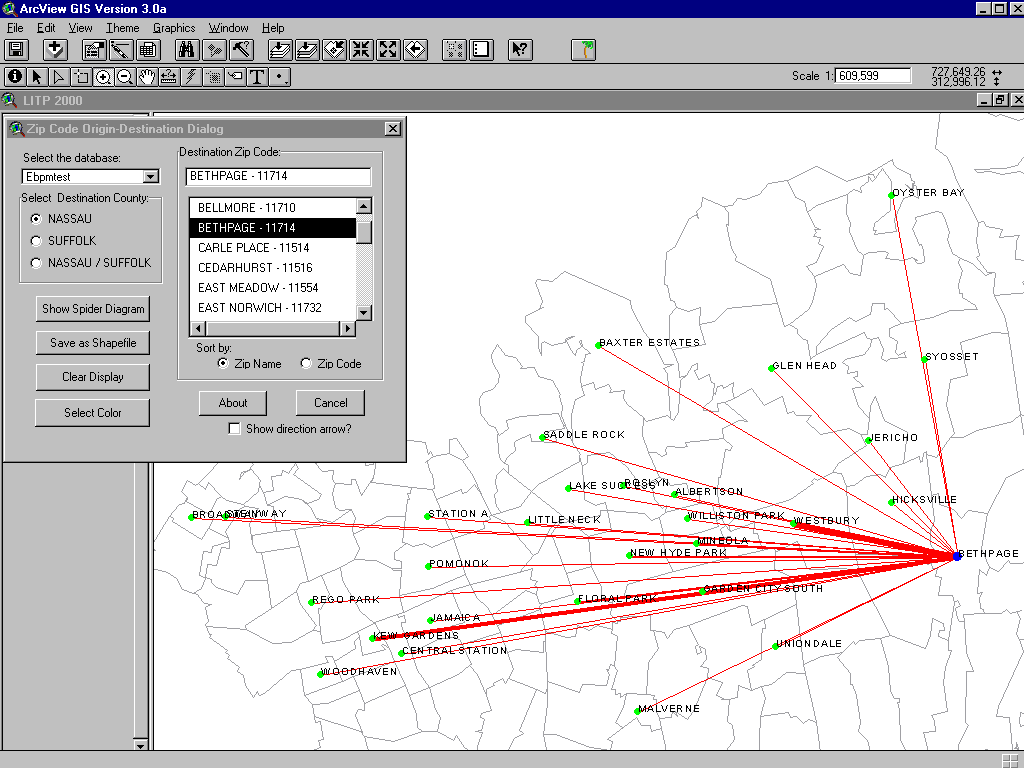
1 - The first illustration shows "spider diagrams" for zip code O-D data collected from eastbound PM survey results. The user can select the destination zip code by name or number. Options exist to change colors, display arrows, or save the results as shapefiles. The thickness of the lines varies proportionally with the number of trips from origin to destination.
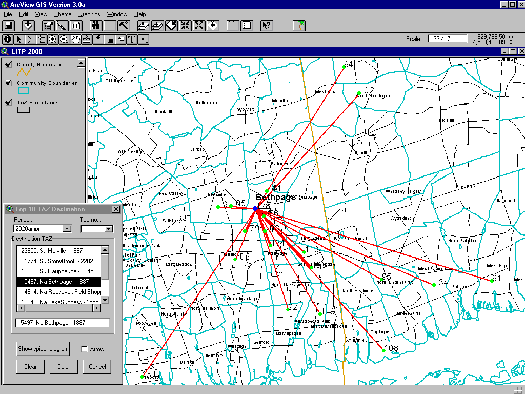
2 - The second graphic shows "spider diagrams" from the TRANPLAN Trip Table output for 2020 AM person trips by Transportation Analysis Zone (TAZ). Since there are many possible origin records, a user can select the top origins for display, varying the number selected. The thickness of the lines varies proportionally with the number of trips from origin to destination.
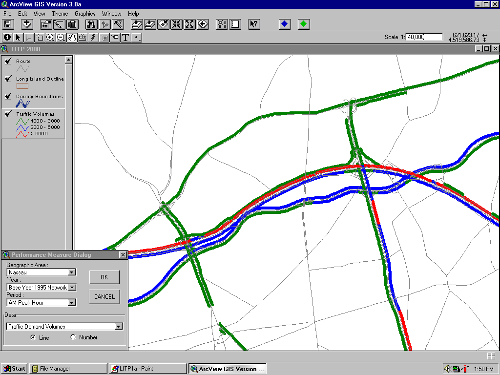
3 - The third graphic shows performance measure output from TRANPLAN for traffic volumes for the 1995 AM Peak Hour base Year network.
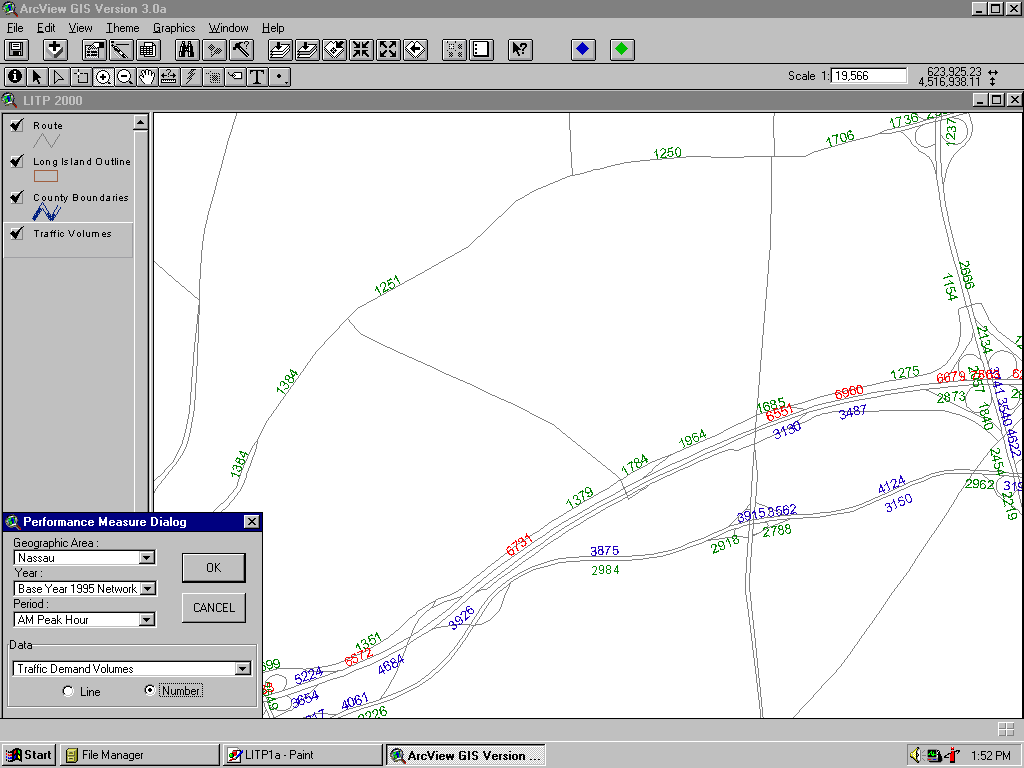
4 - Similar to the third graphic, this illustration shows that in addition to color coding the results, text display is available for the performance measures.
Acknowledgments
The following key individuals are participating in the LITP2000 Study and GIS development. Marvin Gersten - PB Project Manager, Irv Perlman - PB Deputy Project Manager, Doug Swann - GIS Specialist, Stephen Mau - GIS Application Programmer, June Kahng - PB Modeling Coordinator, Wayne Ugolik - NYS DOT Project Manager.
Jules Loweff
GIS Manager
Parsons Brinckerhoff, Inc.
One Penn Plaza
New York, NY 10119
Phone: (212) 465-5413
Fax: (212) 465-5595
E-mail: