Tadashi Ooishi1, Takashi Nanaumi1, Yoshiyuki
Takei1 and Akihito Yamauchi2
Automated Census System for Densely Inhabited Districts
Abstract
Japan has been applying Densely Inhabited Districts (DIDs) as an
urbanization index considering peoples' living environment. DIDs
serve the criteria for the Government's supporting-budget allocation
to the local authorities. However, until past few years, the census
was a manual statistical calculation which was time consuming and
cumbersome. The necessity was realized by the Management and
Coordination Agency of Japan to develop a system for the automatic
compilation of census statistics for DIDs. PASCO developed an
automated system based on ArcInfo to perform iterative calculations
for population density rankings.
1.Background for system development
The Statistics Bureau and Statistics Center of the
Management and Coordination Agency of Japan developed an Automated
Census Mapping System (CMS) by applying the Geographic Information
System technology. The geographic data of Basic Unit Block boundaries
introduced in the 1990 population census and the attribute data of
population census are registered in the database by this system,
which made it possible to understand statistical maps and
distribution maps using Graphic user interface.
The population census adopts Basic Unit Blocks as the most basic
small-data units, and thereby allows the compilation of statistical
and distribution maps (which show various information such as
population, number of households, population density, population
growth/decrease rate, percentage of employed persons by industry) for
each prefecture or municipality by processing data based on each
Basic Unit Block. It is also possible to demarcate Densely Inhabited
Districts (DIDs) and process data for small areas such as
subdivisions by cho and aza, school districts, and divisions by health
center jurisdiction or local residents association. A wide range of
applications include the tabulation of the population and number of
households in a commercial quarter within a radius of 500 m from the
station, and the calculation of population and number of riverside
households, which are prone to damages by failure of embankment, in
disaster prevention efforts.
The purpose of introducing the notion of Densely Inhabited
District (DID) was to reveal the urban population based on the
results of population census. In the traditional statistical
presentation, the terms "all shi (i.e.
cities)" and "all gun (i.e. machi (towns) and mura (villages)" were customarily used to
represent urban and rural areas, respectively. However, many towns
and villages were merged under the Towns and Villages Consolidation
Promotion Law of 1953 and the New Towns and Villages Creation
Promotion Law of 1956. This resulted in the involvement of sparsely
inhabited agricultural areas within the boundaries of "all shi" that were originally meant to represent
urban areas. The population density of the "all shi" was consequently lowered, and the term "all
shi" lost its original sense of
urbanity. It was then felt that the statistical data of DIDs were
becoming increasingly inappropriate.
Under such circumstances, the Statistics Bureau introduced a new
definition of boundaries that would clearly represent urban areas in
the 1960 population census. As a result, statistical data that were
the accurate representation of the actual state of urban population
were provided. These data are now widely used as a criterion for
calculating local allocation taxes, and as a valuable source for
establishing such administrative policies as town planning, regional
development programs, urban redevelopment programs, industrial
location planning, transport planning, public health policies and
crime and disaster prevention policies, as well as being applied in
diverse academic and private marketing fields.
At the operational level, however, the demarcation of DIDs took
more than seven months by manual operation. To overcome this problem,
the procedures for demarcating DIDs were redesigned by grouping a
number of districts evaluated as contiguous on the basis of
population and population density (as well as household density) of a
certain level.
To computerize the new demarcation procedures, experimental
studies on system development started in June 1992 based on ArcInfo,
and the development of a prototype system started in February 1993
utilizing the CMS data collected in 1990. This was followed by a
series of verification studies that started in September 1993, which
led to the modification of the prototype system in September 1994.
Furthermore, AML was implemented to suit the new conditions in May
1995, for the purpose of demarcating DIDs in the population census of
the same year. Today, the results of all these efforts are realized
in the Automated Census System for Densely Inhabited District at the
Statistics Bureau of the Management and Coordination Agency of Japan.
2.System overview
The following hardware and software were used for the
development of the Automated Census System for Densely Inhabited
District.
�@�@�@Configurations of major hardware and basic software
|
Hardware
|
RS-6000(IBM) 48H
|
one set
|
|
|
RS-6000(IBM) 25H
|
two sets
|
|
|
X2020�iNScalcomp�j
|
|
|
Basic software
|
ArcInfo
|
rev 6.1.2
|
|
|
bikan-font
|
|
The flow chart for DID demarcation is given in Figure 1.
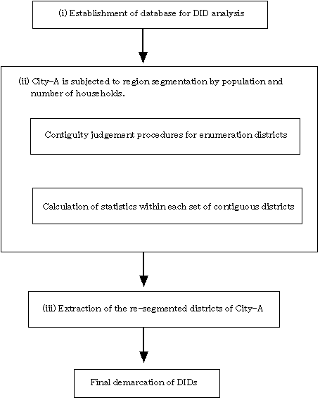
Figure 1. Flow chart for DID
demarcation
(i) Database construction for DID analysis
Flags were added to each attribute of enumeration
districts for DID demarcation. Table 1 shows the data characteristics
of enumeration districts and the respective flags.
Table 1 Condition for database construction
|
Data characteristics
|
Flag
|
|
Enumeration districts with a population density of X
X (inhabitants/ km2) or more
|
�`
|
|
Enumeration districts with a population density of X
X (inhabitants/ km2) or more in the area
excluding the surface area of urban public facilities
|
�a
|
|
Enumeration districts defined as the DIDs in the 1990
census which have a population density of Y Y
(inhabitants/ km2) or more
|
�b
|
|
Enumeration districts in which the DIDs defined in the
1990 census account for Z Z% or more and which have a
population density of X X (inhabitants/
km2) or more in the area excluding the surface
area of urban public facilities
|
�c
|
|
Any enumeration districts in which the surface area of
urban public facilities account for Z Z% or more
|
�d
|
|
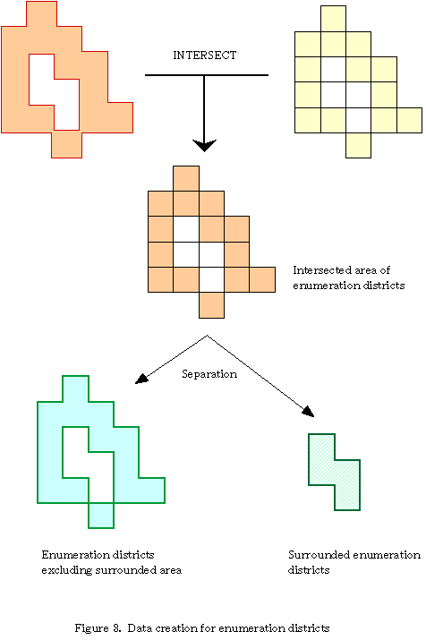
Other enumeration districts including those surrounded by
the districts defined as above (see the data processing
procedures shown in Fig. 3), and those involving isolated
lands
|
�e
|
|
* The following thresholds have been set here as an
example.
X X as 4000, Y Y as
2000 and Z Z as 50
|
|
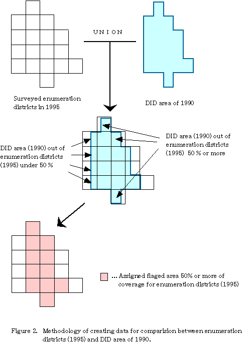
The flow charts given in Figure 2 and 3 were adopted to create the
data shown in Table 1. Figure 2 shows the database construction
procedures that are adopted for cases where the DIDs of 1990 and the
enumeration districts of 1995 are different. For example, if the
boundaries of a district do not match, as shown in the figure, the
district is demarcated with a threshold of 50%.
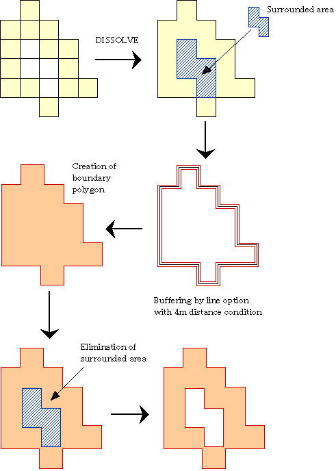
Figure 3 shows procedures for judging whether an area surrounded
by DIDs should be included in the DID. For example, if its surface
area is less than 0.5 km2, it is included in the DID, but
left as a blank area if its surface area is more than 0.5
km2.
�@
(ii) Segmentation of City-A
For detailed statistical analysis of a city, region
segmentation is performed on the basis of population, number of
households, and the contiguity of enumeration districts.
1) Definition of the contiguity of enumeration districts
The contiguity of enumeration districts is defined as
follows:
|
�P
|
Those adjacent to each other at a point or on a side are
regarded as contiguous
|
(top left in Fig. 4)
|
|
�Q
|
Those separated by a distance of 8 m or less are regarded
as contiguous
|
(bottom left in Fig. 4)
|
|
�R
|
Those surrounded by other enumeration districts that have
a total surface area of less than 0.5 km2 are
regarded as contiguous
|
(top right in Fig. 4)
|
|
�S
|
Where all the districts apart from water enumeration
districts of a municipality are regarded as contiguous, the
whole area of the municipality including the water
enumeration districts is regarded as a single DID
|
(bottom right in Fig. 4)
|
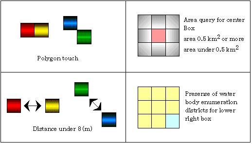
Figure 4.
Definition of contiguity
2) Evaluation criteria for contiguous districts
Searching the districts defined as contiguous in the
way described in the table above, the contiguous districts are
evaluated based on the statistics. Three thresholds are set: a
population of Level A or more, Level B or more and less than Level A,
and Level C or more and less than Level B.
* The following thresholds have been set as an example here.
�@�@�@Level A as 5000, Level B as 3000, Level C as 1000
(iii) Extraction of the re-segmented districts of City-A
The contiguous districts are marked with DID numbers.
In this way, several districts with a dense population within a city
can be modeled as shown below.
The comparison between the old procedures and the new system is
given in Table 2, which demonstrates the efficiency of the latter.
Table 2. DID numbers and their conditions
|
Naming
|
�c�h�c No.#
|
Conditions
|
|
�c�h�c
|
�P�`�T�O
|
The total population of the contiguous districts is Level
A or more (Numbers are given, starting from 1, in the order
of decreasing population).
|
|
Quasi-�c�h�c
|
�T�P�`�V�O
|
The total population of the contiguous districts is Level
B or more and less than Level A (Numbers are given, starting
from 51, in the order of decreasing population).
|
|
Planed districts
|
�V�P�`�X�X
|
The total population of the contiguous districts is Level
C or more and less than Level B (Numbers are given, starting
from 71, in the order of decreasing population).
|
* See "2) Evaluation criteria for contiguous districts" for
the details of Level A, B and C.
Figure 5 shows contiguous block patterns regarded as DIDs
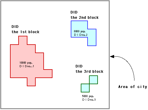
Figure 5 Contiguous block model with DID numbers
3. Demarcation display
Below is an output example of DID demarcation of a
city carried out in 1995. The area bounded by blue lines is defined
as a DID which is the final target area of demarcation. Red lines
represent the DID boundaries defined in the 1990 census, which
demonstrates well the changes during the five years. The tint black
lines represent enumeration districts. This boundary map of DID shows
well that the city is being divided into small districts.
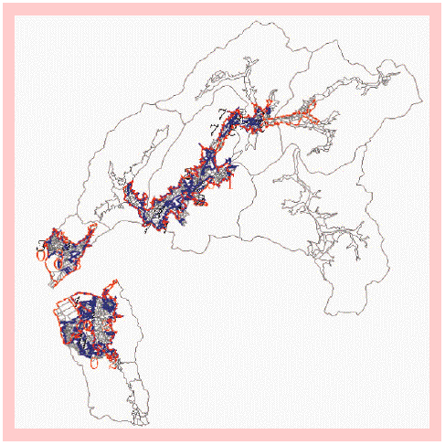
Table 3. Comparison between the new system and old
procedures
|
|
Old manual procedures
|
Automated Census System for Densely Inhabited District
|
|
Data entry
|
Enumeration districts maps: A-2 size each
|
By means of the CMS (for each municipality)
|
|
Area calculation
|
Reading of the planimeter twice
|
By means of the basic functions of ArcInfo
|
|
Calculation of population density
|
By means of the host computer (ACOS)
|
By means of EWS (RS-6000)
|
|
Boundary demarcation
|
Transferring onto the topographical maps drawn on a scale
of 1: 25000 produced by the Geographical Survey Institute,
the Ministry of Construction.(Certain errors are produced
because the enumeration districts maps are on the plane
rectangular coordinates while the topographical maps are on
the Universal Transverse Mercator system.)
|
Demarcation data are saved as attributes.(The data are
archived on the plane rectangular coordinates.)
|
4. Conclusions
PASCO developed an Automated Census System for Densely
Inhabited District based on GIS to enhance the efficiency of
procedures which was time consuming demarcation and cumbersome manual
process. The highlighted results include: (i) demarcation period was
reduced from 7 months to 3 months (less than a half); (ii) surface
area accuracy of data was improved from the conventional accuracy of
around 1:25000 by compiling on more accurate scales including 1:
2500; (iii) it became possible to avoid human errors by utilizing
computers; and (iv) certain demarcations that had hitherto been
regarded difficult to be performed by other GIS systems were made
possible by employing various overlay functions of ArcInfo.Future
objectives include the establishment of DID calculation for cases
where districts are divided by man-made facilities such as railways
or by natural boundaries such as rivers, as well as the further
improvement and application of the GIS technology.
Acknowledgment
In developing this system a great deal of assistance was received
from the Population Census Division of the Statistical Bureau of
Management and Coordination Agency.
Reference
(i) Population Census of Japan (Densely Inhabited Districts), 1990
(ii) Population Census of Japan Analytical Series No.3 (Densely
Inhabited Districts), 1995
Author Infomation
Name
Tadashi Ooishi1, Takashi Nanaumi1, Yoshiyuki
Takei1 and Akihito Yamauchi2
Title
Automated Census System for Densely Inhabited Districts
Address
1PASCO CORPORATION 1-1-2, Higashiyama, Meguro-ku, Tokyo
153, Japan TEL:+81-3-3715-1530, FAX:+81-3-3715-1470
E-mail:tadashi_ooishi@sed.pasco.co.jp
2 Management and Coordination Agency Government of
Japan 19-1, Wakamatsu-cho, Shinjuku-ku, Tokyo 162, Japan
TEL:+81-3-5273-1134, FAX:+81-3-3203-8358