Integrating Landscape
Structure Programs with ArcInfo
Joseph K.
Berry, David J. Buckley, and Kevin McGarigal
ABSTRACT
Most approaches in integrating geographic information
systems (GIS) and existing forest management programs use import and export of data
exchange files between distinctly separate programs requiring considerable programming
knowledge of system syntax, file types and formats, custom conversion programs and
operating system procedures. Intimidating and confusing mechanics of the linkage has
severely limited effective use of GIS in landscape analysis. A tight integration of data
and processing capabilities are vital to successful resource applications. Coding
landscape structural analysis within a GIS environment provides significant advantages in
data conditioning, processing speed, and extended analysis capabilities. Users interact
through cascading graphical menus to easily identify geographic extent, map features,
processing parameters and output specifications for their study. Computer processing takes
advantage of the set of mathematical, statistical and spatial operators within GIS
programming languages to expedite program development, increase performance and enhance
traditional landscape indices. This integration of raster and vector techniques also
provides new indices, such as considering "effective distance" in computing
proximity-related metrics. This paper discusses the differences in application development
between loosely and tightly integrated approaches in linking GIS and landscape analysis.
Examples using the FRAGSTATS*ARC system linking the ArcInfo and FRAGSTATS programs are
used to reinforce the concepts presented.
Introduction
How will forest vegetation change in response to natural
succession, imposed disturbances, and proposed management actions? How will these changes
affect ecosystem values? How do changes in the shape, pattern and arrangement of forest
parcels modify flows of energy, materials and species? Answering these questions requires
a synthesis of scientific knowledge about important ecosystem components and a means for
integrating the knowledge in a format useful to resource managers.
Ecosystem management at any scale requires comprehensive
data sets and robust analysis procedures. Currently the most common landscape analysis
scale being used is at the watershed level. The question now is whether resource managers
can take advantage of the large investments in detailed geo-referenced data at the stand
level in developing advanced analytical techniques for ecosystem management at larger
scales. A major obstacle is the procedural complexity of an integrated environment for the
storage, processing and display of mapped data used in forest simulation and landscape
analysis. Currently the linkage involves a litany of independent and specialized programs
that severely limit rapid map displays and comparisons of future conditions for direct
interpretation by forest managers. Communication between these systems and GIS data has
been left to end-users and requires considerable programming knowledge of both
systems’ syntax, file types and formats, custom conversion programs and operating
procedures. The intimidating and confusing "mechanics" of the linkage has
severely limited the effective use of GIS, particularly in landscape structure analysis.
This paper describes the major considerations affecting
successful integration of landscape structure analysis and GIS systems. The FRAGSTATS*ARC
software (IGIS 1997) is used to demonstrate the linkage of the U.S. Forest Service’s
FRAGSTATS program (McGarigal and Marks 1995) to the ArcInfo GIS (Esri 1992). The tightly
integrated system utilizes a graphical user interface that controls program specification,
data management, data processing and output display. The structure and organization of the
menus form an intuitive, "wizard-like" approach that leads a user, step by step,
through program specifications needed to perform the analysis identified by the user.
Linking GIS and Landscape Analysis
Capabilities
FRAGSTATS is an extensively used program that derives a
comprehensive set of useful landscape metrics. The ArcInfo system (Esri 1992) is a
powerful, workstation-level GIS that is widely used by natural resource agencies,
organizations and companies. Many agencies and companies have spent much of the last 10
years compiling expensive and comprehensive vegetation inventories that describe their
areas of responsibility. However, most often this wealth of descriptive data has only been
utilized for basic mapping purposes. The benefits from analyzing this data, using GIS
analysis functions or by using externally developed analysis models or programs, has yet
to be realized. However, most GIS systems were justified and acquired based on these
analysis expectations.
Internal Versus External Linkage Techniques
Two basic programming techniques exist for linking
landscape analysis models with ArcInfo. These are:
 |
internalizing the model/program
by programming with ArcInfo functions using the GIS' programming languages, e.g. AML,
GRID, etc.; or |
|
maintaining the external programs
outside of ArcInfo and communicating with the model/program through
inter-application communication techniques. |
Internalization of the landscape analysis model/program is
typically desirable. Most GIS software, and in particular ArcInfo, provides rich
programming languages, (e.g. AML, GRID), and a comprehensive suite of spatial analysis
functions. There are several advantages to this approach including:
|
data formatting and management
requirements are minimized since the GIS inherently takes care of these data
integration requirements; |
|
a comprehensive suite of spatial
operators and functions is available; |
|
seamless support for both vector and raster data formats
and processing techniques; |
|
typically faster processing performance; and |
|
hardware / operating system platform independence of the
application. |
The primary disadvantage of internalizing the model/program
is that frequent re-programming of an existing model, e.g. coded in FORTRAN, C, etc., is
cost prohibitive. In many cases the model has been developed over many years and can be
fairly large. Significant effort would be required to duplicate the model in the
GIS. This effort is typically viewed negatively - why re-code the model when it is already
done ? As well, an extensive knowledge of ArcInfo is required before any internalization
can be undertaken. In many cases this level of expertise is not readily available to the
researcher or scientist.
If a substantial amount of development has already been
undertaken on an external model/program it is usually desirable to maintain the model outside
of ArcInfo. However, this approach requires developing a mechanism for ArcInfo to
interact with the model. Interaction requirements usually involve data input and
definition, data conversion (to a format the model can read), passing of parameters for
the model run, execution of the model/program, and conversion of the model output to an
ArcInfo compatible format for display purposes. In most instances a graphical user
interface (GUI) is developed with ArcInfo, historically ARC Macro Language (AML) based.
The easiest approach is to utilize the ArcInfo application GUI as the front end
for the model execution. The GUI does not directly interact with the model during
execution , but rather is used to define parameters for the model run. The passing of
parameters to the external program can occur in a variety of ways. The number of
parameters will help determine the most appropriate method for passing arguments and
parameters to the external program. In cases where numerous parameters are required the
use of ASCII parameter files is best. In many cases ASCII parameter files are
already used by the external model. In this regards, the ArcInfo GUI is simply used to
write parameters files and for display of output.
The public domain version of vector FRAGSTATS developed by
McGarigal and Marks utilized the external program approach. Much of the data input and
processing was done with ArcInfo AML, but the indices calculation was done with C
programs, i.e. edge contrast metrics. The ArcInfo AML code utilized functions to prepare
the spatial data for analysis, converted the data into ASCII files, and then called
the C programs for calculating metric output. In this context no direct interaction
occurs, other than ArcInfo executing the C program.
More recently inter-application communication (IAC)
capabilities have been added to the ArcInfo AML affording more direct interaction between
external programs and ArcInfo. These techniques allow spawning of multiple
independent tasks, i.e. model runs, simultaneously from the ArcInfo GUI. This is ideal
for batch like processing. In this regard the client GUI is released after
initiating a model run. The external program acts like a server process echoing
messages back to the GUI depending on status. The GUI is free to interrogate previous
model run output. The GUI can communicate with the model server at any time by sending
requests to the server process. This is ideal for changing parameters during iterations of
a model.
The IAC approach is ideal for integrating complex
simulation models having many parameters with ArcInfo. Multiple simulation runs can be
started at once, and parameters can be changed interactively through the GUI to adjust the
model based on interpreted output. This approach has been successfully implemented with
the CAPARS system that integrates sophisticated atmospheric dispersion models with
ArcInfo for emergency response to chemical disasters (Buckley et all 1997).
A primary requirement for managing model/program
integration with a GIS is a meta-data system. Whether the implementation approach utilizes
internal or external linkages, there is a requirement to maintain meta-data information
about each model/program run. A meta-data approach ensures that information about each run
is captured and maintained by the application. This meta-data affords users the ability to
re-visit runs for display, interpretation and/or evaluation. The meta-data tells the user
about the specific model/program run by storing input parameters, characteristics and
output data. A suite of model run management tools is required to aid the user in
managing model run output.
The FRAGSTATS*ARC Integration
Approach
Previously, communication between FRAGSTATS and ArcInfo
has been left to end-users and required considerable programming knowledge of both
systems’ syntax, file types/formats, custom conversion programs and operating system
procedures. Unfortunately, these intimidating and confusing "mechanics" of the
linkage has severely limited the effective use of landscape analysis, in particular
FRAGSTATS, in natural resource planning and management.
A fully integrated link between ArcInfo and FRAGSTATS has
been developed with a single user interface that controls program specifications and
operation, data integration, and output display. The "seamless link" provides a
user-friendly, and intuitive, graphical menu system consisting of scroll lists, toggles
and buttons to facilitate program specifications and automatically generate appropriate
tables, charts and maps for enhanced interpretation of the results. The FRAGSTATS*ARC
interface develops such an environment by controlling:
| 1) the selection of input data; 2) provision of a suite of tools to interrogate and manipulated
ArcInfo spatial and attribute data;
3) selection of FRAGSTATS indices to be calculated, and
definition of required metric parameters;
4) program execution and creation of output data in
ArcInfo formats;
5) creation of meta-data files for control and tracking of
multiple runs; and
6) display of results in a variety of tables, charts and
map displays. |
The FRAGSTATS*ARC interface focuses primarily on internalization
of the FRAGSTATS program. To take advantage of the inherent data management and processing
capabilities found within ArcInfo all indices calculations have been internalized and
programmed in AML. All C code has been eliminated. This results in better data and file
management, and also in significant performance enhancements. Internalizing the program
calculations has been designed to take advantage of the inherent database management
(DBMS) table capabilities inherent in ArcInfo. With this approach specific indices are
only calculated once for the entire data set. DBMS table calculations inherently work on
all features (polygons/records) with a single command. Previously with the public domain
version of FRAGSTATS each indices was executed separately for every feature. Accordingly,
execution times are significantly reduced with average program runs taking minutes instead
of hours. This provides an operational framework for adding many new indices to FRAGSTATS,
and embedding FRAGSTATS within other analysis applications, such as timber supply models,
or harvest planning applications.
FRAGSTATS*ARC also utilizes the inter-application
communication (IAC) approach for program integration. Under a comprehensive meta-data
framework multiple FRAGSTATS program runs can be initiated using IAC methods. The IAC
method has been implemented to afford batch processing of program runs. Individual
FRAGSTATS runs are queued up as separate FRAGSTATS servers freeing up the interface
for use.
( Click on the image to view
more detail ) |
|
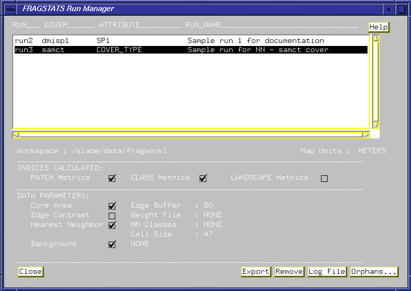
Figure 1. The FRAGSTATS
Run Manager provides users a meta-data based framework for referencing FRAGSTATS runs. The
suite of tools allows the user to manage existing runs, and select an active run for
review. The main parameters of each run are stored as meta-data and can be recalled at any
time by the user by simply selecting from the list of existing runs. Each new FRAGSTATS
run will automatically add meta-data about the run to the meta database. |
The FRAGSTATS*ARC Application Desktop
The FRAGSTATS*ARC desktop interface provides a common
processing environment and graphical interface for running FRAGSTATS within ArcInfo. User
specifications for input data, FRAGSTATS analysis parameters and ArcInfo output options
are made by toggling options in a series of procedural, step-by-step, menus. The general
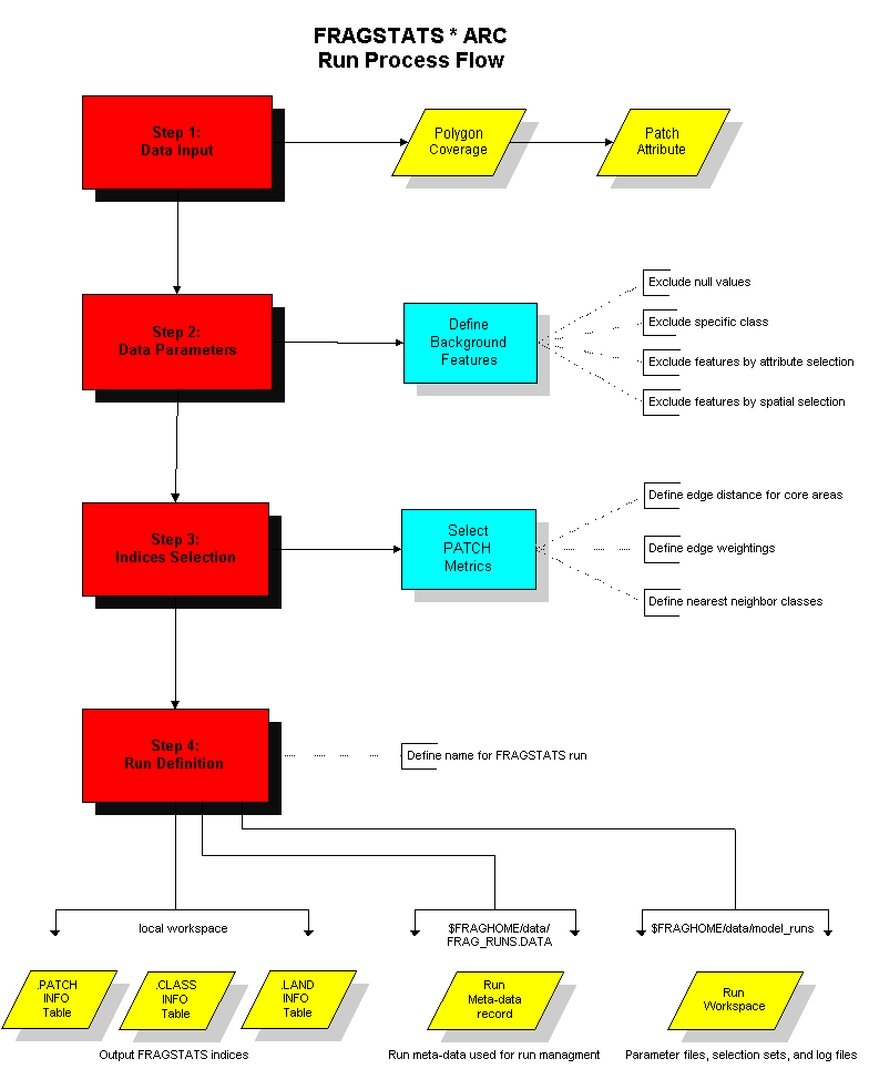
FRAGSTATS run process flow is illustrated in Figure 2.
|
Figure 2. The primary
interface for initiating a FRAGSTATS run involves a series of procedural, step-by-step,
tasks. These are presented to the user as a Wizard like interface that prompts the user
through the selection of input data, indices for calculation, and parameter definition.
This flowchart illustrates the basic steps in initiating a FRAGSTATS run. |
The FRAGSTATS*ARC desktop enables scientists and managers
to interact with both FRAGSTATS and ArcInfo without extensive procedural knowledge of
either system. It tightly integrates both systems in a friendly environment allowing users
to directly concentrate on ecological planning and management implications, without the
distracting "mechanics" of program control and output generation.
FRAGSTATS*ARC has been designed with a fixed format menu
interface that mimics the conventional Windows interface by placing main menus at fixed
positions on the screen. This approach is often referred to as a desktop. The
diagram shown below illustrates the basic desktop with relative menu areas and positions.
The basic premise of the desktop interface is the definition between graphics windows
space and popup menu space. The desktop utilizes a percentage of the screen, to the left
and below the main menu, for popup menus. The remaining area is designated for the
graphics window.
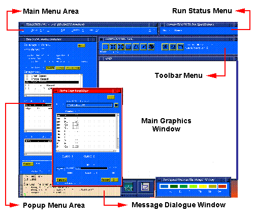
|
Figure 3. The
FRAGSTATS*ARC desktop partitions the screen into distinct areas for different functional
components. This figure illustrates the basic organization of the desktop using the Basic
Interface (see below). |
Basic Versus Advanced Interface
The FRAGSTATS*ARC interface has been designed to
accommodate users with two different levels of ArcInfo experience. The Basic interface
will accommodate most users who have a working knowledge of the ArcInfo data model. The
Advanced interface is intended to supplement the Basic interface capabilities by providing
a more comprehensive suite of ArcInfo data manipulation tools. The more experienced
ArcInfo user, or those needing a complete range of data manipulation and pre-processing
capabilities, will find the Advanced interface more appropriate. The primary capabilities
for pre-processing your data, running FRAGSTATS, and reviewing FRAGSTATS output are
available in both the Basic and Advanced interface. The Basic level is a simplified
pulldown main menu with all the capabilities required to run FRAGSTATS.
The Advanced interface provides a more comprehensive main
menu that also provides access to numerous ArcInfo data management and manipulation
capabilities. These advanced tools provide access to virtually any ArcInfo command. The
Advanced level is intended to satisfy the needs of the more experienced ArcInfo user. In
many situations significant data pre-processing is required before it is ready for
FRAGSTATS processing. A number of data integrity checks have been built into the
FRAGSTATS*ARC data selection tools that notify the user of topological and spatial errors
in the selected input data set. The Advanced interface provides a comprehensive suite of
tools to aid the user in correcting these spatial errors prior to running FRAGSTATS.
Click on the image to view in
more detail |
|
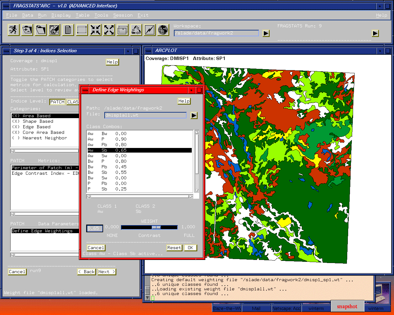
Figure 4. The Advanced
interface of the FRAGSTATS*ARC desktop combines a main pulldown menu with an embedded
toolbar. Step 3 : Indices Selection of the Wizard interface is shown. |
Selecting Landscape Structure
Indices
The step-by-step Wizard interface for FRAGSTATS focuses on
the seamless linkage of indices selection and required parameters. Users are automatically
prompted for required parameters when a specific category of indices are selected for
calculation. Table 1 presents the general categories of indices currently available within
FRAGSTATS*ARC. A user simply has to toggle on the category of metrics they are
interested in to see a list of individual indices for the PATCH, CLASS and LANDSCAPE
level. If a data parameter is required, the user will automatically be prompted through a
popup menu to define the parameter(s).
 The
design of the GUI for metric selection reflects the inherent synchronization between
metrics and required parameters. This mechanism provides an inherent flexibility for
extending indices as the product develops and ensures that required parameters are
automatically linked to categories of metrics for the user. The approach minimizes the up-front
knowledge required from the user, and also instills an understanding of the relationships
between data parameters and indices values with the user. An obvious extension is to
provide the capability for users to add their own indices to the metrics list with future
releases of FRAGSTATS*ARC.
The
design of the GUI for metric selection reflects the inherent synchronization between
metrics and required parameters. This mechanism provides an inherent flexibility for
extending indices as the product develops and ensures that required parameters are
automatically linked to categories of metrics for the user. The approach minimizes the up-front
knowledge required from the user, and also instills an understanding of the relationships
between data parameters and indices values with the user. An obvious extension is to
provide the capability for users to add their own indices to the metrics list with future
releases of FRAGSTATS*ARC.
Figure 5. The indices selection menu enables users to
select categories and levels of indices to be calculated. The required parameters are
automatically identified and prompted for.
Figure 5 shows the main metric selection menu. By toggling
on a category(s) for calculation, the list of individual indices, and required data
parameters, are refreshed in the lower scroll lists. The Categories, representing logical
orderings of individual indices, and data parameters are linked at this level. It was
decided that the provision of required data parameters menus for individual indices would
be information overload for the average user, and would result in a less than
intuitive interface.
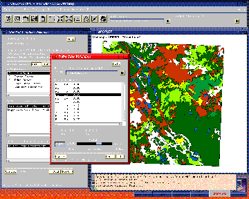
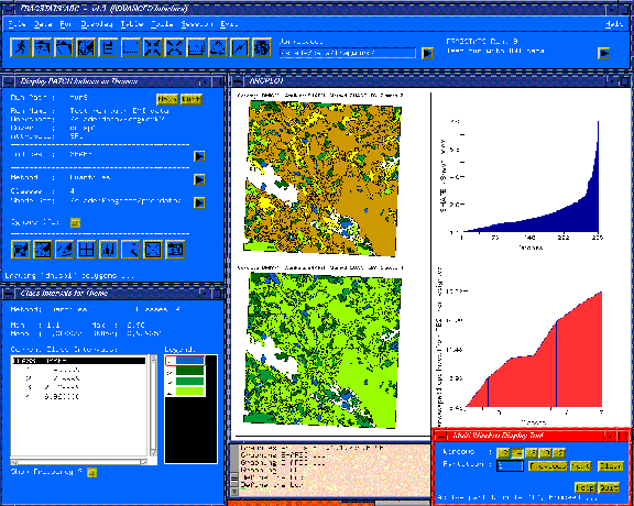
Intregrated Query and Display
Capabilities
Another inherent advantage of internalizing the FRAGSTATS
program into ArcInfo is the availability of the GIS' display and query functions. A major
impediment of the public domain FRAGSTATS is the lack of integration with the GIS display
tools, and the substantial ArcInfo knowledge required to convert FRAGSTATS output to a
compatible format needed to generate meaningful displays.
With FRAGSTATS*ARC the output metric tables are seamlessly
linked with the input polygon coverage providing an array of query, listing, reporting,
and display capabilities. A full range of table listing and reporting tools are provided
that transparently operate on the FRAGSTATS output tables without the user requiring
knowledge of file names or command syntax. Users simply select a FRAGSTATS run (through
the meta-data interface) and the query, display or reporting tools automatically use the
output for the active run. In addition to the table reporting tools, a robust thematic
mapping interface is provided allowing users to generate multiple displays of output
indices. Also, a tool is provided to aid the user in defining an appropriate legend
(definition of classes intervals) based on the frequency distribution of the individual
metric. Figure 6 presents an example of the primary thematic mapping tool.
Click on the image to view in
more detail |
|
Figure 6. The thematic
mapping tools provided with FRAGSTATS*ARC seamlessly link output metric tables with the
ArcInfo input coverages to facilitate display and interrogation of landscape indices.
Tools are provided for graphing, thematic mapping, and automatic calculation of optimal
class intervals for quantitative output. |
In addition to the thematic mapping tools, a comprehensive
query environment is included. The query tools seamlessly link the output metrics with the
input ArcInfo coverage and provide a robust interface for querying FRAGSTATS results. A
full range of query capabilities are provided including attribute, spatial and topological
query functions allowing the user to address virtually any query requirement. This
includes the overlap of other data sets, ( roads, riparian buffers, etc.) with the source
polygon data coverage. The query environment is designed around a query ladder that
automatically tracks the user's query logic in a step-by-step manner. Users can walk up
and down the query ladder revising their logic and query specifications as desired
based on the results of query steps. This approach provides maximum flexibility for
defining queries, and modifying them based on the characteristics of a specific data set,
or the results of the FRAGSTATS analysis. The thematic mapping and formatted reporting
tools are seamlessly integrated with the query environment allowing users to generate maps
and reports based on query subsets. Query logic can also be saved across sessions and
restored for future query sessions.
Click on the image to view in
more detail |
|
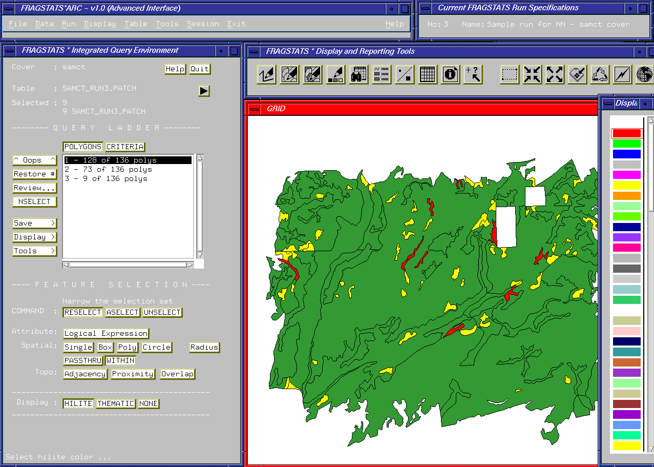
Figure 7. The
FRAGSTATS*ARC query environment provides a desktop for querying FRAGSTATS output metrics
linked seamlessly with the ArcInfo coverage. The Query Ladder approach automatically
tracks the user's query steps and presents those in a scroll list. Query steps can be
added at any time by using the primary attribute, spatial and topological query functions.
The combination of these functions with the query ladder approach provides unlimited
flexibility for addressing virtually any query need without a requirement for advanced
ArcInfo knowledge by the user. |
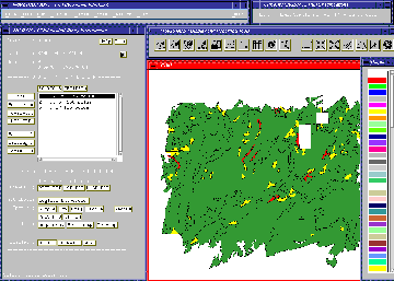
Figure 7 illustrates an example of a query for small,
irregular aspen stands. This example is composed of three simple attribute (by logical
expression) steps where the output PATCH indices where queried for:
- Dominant species = Aspen
- Area less than 15 ha
- Shape index greater than 2.0 (fairly irregular).
These areas are displayed as RED in the figure. Using the
topological functions this query could easily be extended to address concerns of
proximity, adjacency to other features, e.g. roads, or where queried features overlap with
other features, such as high suitability areas.
The query environment provides tools to help the user in
flexibly defining their own query logic, and modifying the logic as they dictate based on
their interpretation of the query results. This approach is intended to guide the user
without imposing fixed processing steps, or a prerequisite knowledge of ArcInfo analysis
commands. It is expected that more comparative functions will be added with future
releases to further aid the user in interpreting FRAGSTATS output.
Extending Landscape Analysis
Capabilities
Landscape ecology provides a strong conceptual and theoretical
foundation for understanding landscape structure, function and change. These factors can
be defined as: "structure" is the spatial relationships among the
distinctive ecosystems, or spatial elements, present; "function"
identifies the interactions among the spatial elements; and "change"
is the alteration in the structure and function of the ecological mosaic over time (Forman
and Gordon 1986). The ability to quantify landscape structure is prerequisite to the study
of landscape function and change. For this reason, considerable emphasis has been placed
on the development of landscape metrics.
Many of the relationships can be expressed by indices derived
through analysis of the shape, pattern and arrangement of three landscape element "levels":
1) individual patches (e.g., vegetation polygon), 2) classes of related patches (e.g.,
polygons of the same type/condition), and 3) entire landscape sets (e.g., all polygons).
In addition to characterizing landscape indices by the level of spatial elements, they can
be grouped by broad "categories" identifying the nature of the
processing. These categories include area, patch density/size/variability, edge, shape,
core area, nearest neighbor, diversity and contagion/interspersion metrics (see Table 1).
Table 1. Metrics computed in FRAGSTATS, grouped by
subject area. See McGarigal and Marks. (1995) for mathematical definition of each metric.
(mu) represents map units (meters or feet).
Category
Metric |
Acronym |
Metric Description
(units) |
| Area Metrics |
|
|
| Patch |
AREA_HA |
Area (ha) |
| Patch |
LSIM |
Landscape
similarity index (%) |
| Class |
CA |
Class area (ha) |
| Class |
PLAND |
Percent of
landscape (%) |
| Class/landscape |
TA |
Total landscape
area (ha) |
| Class/landscape |
LPI |
Largest patch
index (%) |
| |
|
|
| Patch
density, patch size and variability Metrics |
|
|
| Class/landscape |
NP |
Number of
patches (#) |
| Class/landscape |
PD |
Patch density
(#/100 ha) |
| Class/landscape |
MPS |
Mean patch size
(ha) |
| Class/landscape |
PSSD |
Patch size
standard deviation (ha) |
| Class/landscape |
PSCV |
Patch size
coefficient of variation (%) |
| |
|
|
| Edge metrics |
|
|
| Patch |
PERIM |
Perimeter (mu) |
| Patch |
EDCON |
Edge contrast
index (%) |
| Class/landscape |
TE |
Total edge (mu) |
| Class/landscape |
ED |
Edge density
(m/ha) |
| Class/landscape |
CWED |
Contrast-weighted
edge density (mu/ha) |
| Class/landscape |
TECI |
Total edge
contrast index (%) |
| Class/landscape |
MECI |
Mean edge
contrast index (%) |
| Class/landscape |
AWMECI |
Area-weighted
mean edge contrast index (%) |
| |
|
|
| Shape
metrics |
|
|
| Patch |
SHAPE |
Shape index |
| Patch |
FRACT |
Fractal
dimension |
| Class/landscape |
LSI |
Landscape shape
index |
| Class/landscape |
MSI |
Mean shape
index |
| Class/landscape |
AWMSI |
Area-weighted
mean shape index |
| Class/landscape |
DLFD |
Double log
fractal dimension |
| Class/landscape |
MPFD |
Mean patch
fractal dimension |
| Class/landscape |
AWMPFD |
Area-weighted
mean patch fractal dimension |
| |
|
|
| Core Area
Metrics |
|
|
| Patch |
CORE |
Core area (ha) |
| Patch |
NCORE |
Number of core
areas (#) |
| Patch |
CAI |
Core area index
(%) |
| Class |
CPLAND |
Core area
percent of landscape (%) |
| Class/landscape |
TCA |
Total core area
(ha) |
| Class/landscape |
NCA |
Number of core
areas (#) |
| Class/landscape |
CAD |
Core area
density (#/100 ha) |
| Class/landscape |
MCA1 |
Mean core area
per patch (ha) |
| Class/landscape |
CASD1 |
Patch core area
standard deviation (ha) |
| Class/landscape |
CACV1 |
Patch core area
coefficient of variation (%) |
| Class/landscape |
MCA2 |
Mean area per
disjunct core (ha) |
| Class/landscape |
CASD2 |
Disjunct core
area standard deviation (ha) |
| Class/landscape |
CACV2 |
Disjunct core
area coefficient of variation (%) |
| Class/landscape |
TCAI |
Total core area
index (%) |
| Class/landscape |
MCAI |
Mean core area
index (%) |
| |
|
|
| Nearest-neighbor
metrics |
|
|
| Patch |
NN_DIST |
Nearest-neighbor
distance (mu) |
| Patch |
NN_POLY |
Nearest
neighbor polygon id (patch id) |
| Patch |
PROXIM |
Proximity index |
| Class/landscape |
MNN |
Mean
nearest-neighbor distance(mu) |
| Class/landscape |
NNSD |
Nearest-neighbor
standard deviation (mu) |
| Class/landscape |
NNCV |
Nearest-neighbor
coefficient of variation (%) |
| Class/landscape |
MPI |
Mean proximity
index |
| |
|
|
| Diversity
Metrics |
|
|
| Landscape |
SHDI |
Shannon's
diversity index |
| Landscape |
SIDI |
Simpson's
diversity index |
| Landscape |
MSIDI |
Modified
Simpson's diversity index |
| Landscape |
PR |
Patch richness
(#) |
| Landscape |
PRD |
Patch richness
density (#/100 ha) |
| Landscape |
RPR |
Relative patch
richness (%) |
| Landscape |
SHEI |
Shannon's
evenness index |
| Landscape |
SIEI |
Simpson's
evenness index |
| Landscape |
MSIEI |
Modified
Simpson's evenness index |
| |
|
|
| Contagion
and Interspersion metrics |
|
|
| Class/landscape |
IJI |
Interspersion
and Juxtaposition index (%) |
| Landscape |
CONTAG |
Contagion index
(%) |
Processing approach and data handling procedures ultimately
determine the efficiency and capabilities of an integrated system. As a stand-alone
system, the metrics in the original FRAGSTATS program were calculated both in AML macros
and for more complex indices, in external C programs. Data preprocessing was performed in
the GIS and specially formatted import files were used to transfer data to C programs.
Internal processing involved a series of programming loops that operated on individual
spatial items (polygon features). Results were written as a formatted report, with no
provisions for viewing the results in map form. Some capabilities exist to unload
the output reports into ASCII delimited files that could be loaded into a DBMS of choice.
However, this process is manual and in-direct. As noted in the previous sections of this
paper, the primary operational limitations of such a loosely integrated system were its
procedural complexity and ineffective presentation of results. The major technical
limitations included inefficiencies in program development, maintenance, performance and
extension.
Vector Versus Raster Processing
Techniques
Most of the metrics identified in Table 1 can be evaluated
in both vector and raster data structures. The original public domain version of FRAGSTATS
was available as two distinct programs to support vector or raster data formats. The
vector version supported ArcInfo polygon coverage format through a loose integration
between AML and C programs. The raster version is a stand-alone C program that supports a
small array of raster data formats. No direct support for ArcInfo GRID format is
provided. Accordingly, considerable effort was involved in developing, modifying and
maintaining the two programs. Additionally, specific indices were only available in the
raster version, and not the vector version.
In contrast, the FRAGSTATS*ARC system is programmed
entirely within the GIS macro language (AML). This approach replaces the AML/C integration
of the vector version (and the C code of the raster version) with a single development
environment using direct GIS function calls. This approach significantly streamlines
program development and maintenance and affords seamless integration of vector and raster
data processing techniques. This provides a programming framework for extending the list
of metrics fairly easily in the future. The next version of FRAGSTATS*ARC will provide a
suite of new indices, and will provide capabilities for the user to create their own
indices. In this regard, the list of metrics is user extendable. This flexibility
is made possible the internalization into the GIS programming language and taking
advantage of the inherent GIS functional capabilities.
With this design the user does not need to be aware of the
processing technique (vector versus raster) that will be utilized to calculate a
particular metric. The software automatically converts data on-the-fly to/from
vector-raster input sources depending in the requirements of the category of indices
selected for calculation. The current version supports vector polygon data input and
converts to raster GRID's as required. This accommodates the growing list of metrics that
are inherently raster based. The next version of FRAGSTATS*ARC will also support direct
raster input data, and provide vector polygon conversion where required.
In addition, the GIS programmed version realizes
significant increases in performance. The performance of the core FRAGSTATS metric
calculations has been significantly enhanced. Calculations are now done directly on linked
data tables reducing run times to minutes from hours ! In addition, run times for large
data sets (coverages) do not increase linearly. Run times for large coverages only
increase a minor amount due to the use of the DBMS table calculation techniques inherently
available in the GIS. For example, Table 2 reflects the results of tests undertaken on a
small and medium size data set with the new FRAGSTATS*ARC software versus the public
domain version.
Table 2. Comparison of processing times for FRAGSTATS
programs.
Data
Set Size (polygons) |
FRAGSTATS*ARC |
Public
Domain FRAGSTATS |
80 |
27
seconds |
6
minutes |
600 |
45
seconds |
1 hour
20 minutes |
Future Efforts
The extended spatial analysis operations in most GIS
packages provide new opportunities for extending data handling and analytic capabilities.
For example, vegetation maps at different years can be compared, the transition zones
isolated as a new set of spatial elements, and the structural character of the derived
data set analyzed. The "effective proximity" operator in most grid-based GIS
systems can be used to extend many of the indices. For example, the "nearest
neighbor" metrics identified in Table 1 currently uses simple proximity based on
straight-line connectivity to establish distance among spatial elements. Under this
limiting assumption, two elements will be identified as close (as the crow flies),
although they are divided by open water that restricts seed, animal and other movements
between them. By simply introducing a direct call to the extended set of spatial
operators, such as effective proximity, new and more realistic indices are easily
developed.
Similarly, spatial statistics provides new
"tools" for comparing and summarizing the results of structural analysis. For
example, the maximum, minimum, range and average of indices can be easily derived through
"region-wide (zonal)" operators for subsets of a project area, such as all
locations with steep, northern slopes. Comparative and predictive spatial operators, as
well as descriptive statistics, can provide new and useful "views" of landscape
structure relationships. Most GIS systems provide investigative tools, such as clustering
and regression, as direct function calls. These tools readily extend landscape structure
analysis to other spatially dependent variables, such as the distribution of animal
populations.
Extending Landscape Metrics
An extension project for FRAGSTATS*ARC is planned to
provide additional landscape structure indices and new capabilities for generating custom
queries and rapid comparison of landscape indices. It will enable a user to launch several
landscape structure analyses, then generate comparative statistics and output these
results as a variety of tables, charts and map displays. For example, a user might compare
three harvesting scenarios for an area to determine which indices significantly change and
output the results a map of affected landscape units.
In addition, development of a Windows 95/NT version (a GIS
platform independent version based on Esri MapObjects software) is under consideration.
This version will link to standard desktop mapping systems, supporting formats such as
ArcView and MapInfo, as well as ArcInfo. This version will have the additional advantage
of not requiring an ArcInfo license to operate. This will provide greater
flexibility of deploying FRAGSTATS to the end user's desktop. Most importantly, several
new indices and modifications, such as the lacunarity index and various other texture
metrics, will be incorporated within the FRAGSTATS*ARC extensions environment.
Conclusions
The quantification of landscape structure provides a new
set of tools for understanding complex spatial patterns and interactions among landscape
features. They promise new approaches for visualization, formulation and solving of
real-world problems. However, the tools must be tightly integrated into a system designed
for use by resource managers, scientists and other end-users with minimal procedural
knowledge of the programs involved. Several advantages are realized by programming within
the GIS environment:
1) spatially dependent processing is expedited and
extended,
2) program development, maintenance and modification are simplified,
3) data handling is in a common environment, and
4) user interaction with the system is streamlined.
The FRAGSTATS*ARC system tightly integrates FRAGSTATS and
ArcInfo capabilities into a common graphical user environment for storage, processing and
display of mapped data and results germane to landscape structure analysis.
Acknowledgments
Three groups are collaborating on the FRAGSTATS*ARC system.
The original author of FRAGSTATS, Dr. Kevin
McGarigal, provide ecological expertise, algorithm design and computational code
testing. Innovative GIS Solutions, Inc. (IGIS) are the primary software developers for
this project under the direction of David Buckley.
Berry and Associates // Spatial Information
Systems (BASIS) provides project coordination and expertise in GIS modeling and spatial
statistics.
The FRAGSTATS*ARC system extends the original FRAGSTATS
effort supported by the Coastal Oregon Productivity Enhancement Program of which the USDA
Forest Service Pacific Northwest Research Station (PNW) is a major partner.
References
Esri, 1992. Understanding GIS: the ArcInfo method. Redlands,
California: Environmental Systems Research Institute.
Forman, R.T.T. and M. Gordon. 1986. Landscape Ecology. New York:
John Wiley & Sons. 619 p.
Li, , H. 1990. Spatio-temporal pattern analysis of managed forest
landscapes: a simulation approach. PhD. Thesis, Oregon State University, Corvallis,
Oregon. 166 p.
McGarigal, Kevin and Barbara Marks. 1995. FRAGSTATS: spatial pattern
analysis program for quantifying landscape structure. Gen. Tech Rep. PNW-GTR-351.
Portland, Oregeon: USDA Forest Service, Pacific Northwest Research Station. 122 p.
O’Neill, R.V., J.R. Krummel, R.H. Gardner, G. Sugihara, B.
Jackson, D.L. DeAngelis, B.T. Milne, M.G. Turner, B.Zygmunt, S.W. Christensen, V. H. Dale,
and R.L. Graham. 1988. Indices of landscape pattern. Landscape Ecology 1:153-162.
Turner, M.G. 1990. Spatial and temporal analysis of landscape
patterns. Landscape Ecology 4:21-30.
Turner, M.G. and R.H. Gardener (eds.). 1991. Quantitative Methods in
Landscape Ecology. New York: Springer.
Wykoff, W.R., N.L. Crookston, and A.R. Stage. 1982. User’s
guide to the stand prognosis model. General Technical Report INT-133. Ogden, UT: USDA
Forest Service, Intermountain Forest and Range Experiment Station.
Joseph K. Berry, President, Berry & Associates, Inc.
( jberry@innovativegis.com )
David J. Buckley, Principal Consultant, Innovative GIS Solutions, Inc. ( buck@innovativegis.com )
Kevin McGarigal, Assistant Professor( McgarigcalK@forwild.umass.edu
)