Andrew Battin
Russel Kinerson, Ph.D.
Mohammed Lahlou, Ph.D.
EPA's Better Assessment Science Integrating Point and Nonpoint Sources (BASINS) - A Powerful Tool for Managing Watersheds
The US EPA's Water Programs and State environmental agencies have increasingly emphasized
watershed- and water quality-based assessment and integrated analysis of point and nonpoint
sources of environmental pollution. This is a significant departure from traditional approaches in
which watershed is broken down into several separate tasks - involving the application of several
different models and analytical tools. BASINS was developed consistent with the new approach
which makes watershed and water quality studies much easier by bringing key data and analytical
components in one framework, thereby, eliminating the numerous problems that are encountered
in the piecemeal approach. BASINS takes advantage of recent developments in software, data
management technologies, and computer capabilities, and uses Arcview-Geographic Information
System (GIS) as the integrating framework to provide the user with a fully comprehensive
watershed management tool particularly for developing the Clean Water Act (CWA) Total
Maximum Daily Loads (TMDL) which require the integration of both point and nonpoint
sources. This paper demonstrates that BASINS can be used to (1) facilitate examination of
environmental information; (2) provide an integrated watershed and modeling framework; and
(3) support analysis of point and nonpoint source management alternatives.
Introduction
Imagine you work for a state environmental agency with the responsibility for water quality
issues in your state. Your state has a history of water quality problems that have not been
resolved as quickly as concerned citizens and environmental groups desire. Through your day-
to-day contacts you discover rumblings about a little used section of the Clean Water Act (CWA)
which when invoked requires state and federal environmental agencies to calculate Total
Maximum Daily Loads (TMDLs) within water quality impaired watersheds. You recall that over
the past 20 years or so your state has developed fewer than 5 TMDLs. You soon find that the
rumblings you heard manifest itself in the form of a lawsuit that results in a consent decree
thereby requiring your office to develop 500 TMDLs over the next 5 years.
This is not a hypothetical situation. Over 40% of U.S. waters are not attaining their designated
uses. The result is more than 50% of the State Environmental Agencies are being sued by a
variety of organizations to force the development of TMDLs for water bodies not attaining their
designated use. Some states are under court order to develop greater than 100 TMDLs per year
(e.g., Georgia, Idaho). This is an enormous increase in work based on the relatively small
number of TMDLs that had been developed prior to 1995.
While provisions for the development of TMDLs have existed since the CWA was put in place
over twenty years ago, only recently has it gained popularity as a measure to force state and
federal environmental authorities into taking more active measures to achieve water quality
standards.
A TMDL is defined as: TMDL = WLA + LA + MOS
Where:
TMDL = lbs/day (or similar units)
WLA = Sum of Waste Loads (point sources)
LA = Sum of Loads (nonpoint sources)
MOS = Margin of Safety
Under Section 303(d), EPA has the responsibility to perform the TMDLs if the States fail to do
so. How can states and EPA meet such a significant workload increase? What technological
tools are available to assist in meeting the stringent deadline? Prior to 1996 neither the states or
EPA had the tools and information readily available to develop cost-effective TMDLs. This
became more apparent with the increased number of court ordered TMDLs.
Background
The history of Geographic Information Systems (GIS) and water quality modeling evolved
separately. Only within the last few years has a true integration, and widespread availability been
achieved based on advances in GIS technology, particularly at the desktop.
The U.S. Environmental Protection Agency's water programs and their counterparts in states and
pollution control agencies are increasingly emphasizing watershed- and water quality-based
assessment and integrated analysis of point and nonpoint sources. Better Assessment Science
Integrating point and Nonpoint Sources (BASINS) is a system developed to meet the needs of
such agencies. It integrates a Geographic Information Systems (GIS), national watershed data,
and state-of-the-art environmental assessment and modeling tools into one convenient package.
BASINS addresses three objectives: 1) to facilitate examination of environmental information,
2) to provide an integrated watershed and modeling framework, and 3) to support analysis of
point and nonpoint source management alternatives.
It is designed to support the development of total maximum daily loads (TMDLs), which require
a watershed-based approach that integrates both point and nonpoint sources. BASINS can
support this type of approach for the analysis of a variety of pollutants at a variety of scales, using
tools that range from simple to sophisticated. Overcoming the lack of integration, limited
coordination, and time-intensive execution typical of more traditional assessment tools, BASINS
makes watershed and water quality studies easier by bringing key data and analytical components
together "under one roof."
Originally released in September, 1996 (BASINS version 1.0), the heart of BASINS version 2.0
is its suite of interrelated components essential for performing watershed and water quality
analysis. These components are grouped into five categories:
- National databases with local data import tools;
- Assessment tools (TARGET, ASSESS, and Data Mining) that address needs ranging
from large-scale to small-scale, and Watershed Characterization Reports;
- Utilities including Data import, Land use Re-Classification, DEM Reclassification,
Watershed Delineation, and Water Quality Observations Data Management Utilities;
- Watershed and water quality models including NPSM (HSPF), TOXIROUTE, and
QUAL2E; and
- Post-processing output tools.

BASINS Data Products
The data products for BASINS v2.0 have been updated and recompiled to support local data
integration (Table 1). All spatial data are delivered in a decimal degree (unprojected) NAD83 shape file
format with the exception of River Reach File 3 (RF3) which is ArcInfo coverage format to
preserve topology and support analytical functions such as dynamic segmentation. ArcView then re-projects these data in
any user-specified projection upon installation of BASINS 2.0. This enables users to easily
integrate data based on their own commonly used projection. In addition, a greatly expanded set
of data for 477 weather stations (WDM files) for the nation are included. This makes it more
likely that data from a weather station local to the watershed will be available. Other noteworthy
new datasets include: the aforementioned, USEPA Reach File Version 3 Alpha (RF3 Alpha),
DEM elevation data, and STATSGO soils.
BASINS also supports the import and use of various data sets. In addition to standard import
routines for viewing data, BASINS enables import and use of attribute data for use as input files
for the Non-Point Source Model (HSPF). Users can import their own vector datasets such as 5th
and 6th field hydrologic basins delineations, or new vector land use datasets.
Table 1. BASINS Data Products
Spatially Distributed Data
- Land use/land cover (GIRAS)
|
|
| - USGS Hydrologic unit boundaries
|
- Urbanized areas
|
|
| - Drinking water supplies
|
- Populated place location
|
|
| - Dam sites
|
- Reach File, version 1 (RF1)
|
|
| - EPA region boudaries
|
- Reach File, version 3 (RF3)
|
|
| - State boundaries
|
- Soils (STATSGO)
|
|
| - County Boundaries
|
- Elevation (DEM)
|
|
| - Federal and Indian Lands
|
- Major Roads
|
|
| - Ecoregions
|
Environmental Monitoring Data
- Water quality monitoring station summaries
|
|
| - USGS gaging stations
|
- Water quality observation data
|
|
| - Fish and wildlife advisories
|
- Bacteria monitoring station summaries
|
|
| - National Sediment Inventory (NSI)
|
- Weather Station Sites (477)
|
|
| - Shellfish Contamination Inventory
|
- Clean Water Needs Survey
|
|
| |
Point Source Data
- Permit Compliance System
|
|
| - Resource Conservation & Recovery Act (RCRA) sites
|
- Industrial Facilities Discharge (IFD) sites
|
|
| - Mineral Availability System/Mineral Industry Location
|
- Toxic Release Inventory (TRI) sites
|
|
| - Superfund National Priority List sites
|
BASINS Analytical Tools
TARGET is a watershed targeting tool that allows environmental managers to make a
broad-based evaluation of a watershed's water quality and/or point source loadings. It operates
on a large area such as a region or a state.

ASSESS operates on a single watershed (cataloging unit) or a limited set of watersheds and
focuses on the status of specific water quality stations or discharge facilities and their proximity
to water bodies.
Data Mining dynamically links different data elements of water quality or discharge facility using a combination of tables and maps.
This unique linkage adds significant informational value to the raw data on water quality and
loadings. Data Mining is a powerful a tool that can assist in the integration and environmental
interpretation of both geographic and historical information simultaneously.

The Watershed Characterization Report function allows the user to produce hard copies of maps
and summary tables for any watershed or user-delineated sub-watershed, by following a few
simple instructions. A user may generate reports on STORET water quality data for any water
quality parameter at monitoring stations within the study area, and produce a map of the station
locations. Similarly a user can produce a summary of Permit Compliance System dischargers
and loadings of any constituent. Additional reports can be produced to summarize: land use
types (by either Anderson Level I or Level II land use classification system); state soil series
data, and elevation.

BASINS Utilities
A Watershed Delineation Tool allows a user to delineate a sub-watershed from within an 8-digit
cataloging unit using simple mouse point-and-click inputs. With this tool, a user can target any
area within a cataloging unit for more detailed modeling and analysis. In BASINS version 1.0, a
user could only do nonpoint source modeling on the whole cataloging unit. In BASINS 2.0,
Avenue script have been developed to automatically extract geographic information from within
the delineated area, which is then re-formatted as input files for use with the NPSM.

The Land Use Reclassification Tool allows a user to reclassify land use polygons from one land
use category into another. For example, a user may reclassify a single land use polygon from
agricultural to urban. Similarly, the user may select an area using Arc-View's Select Tool and
reclassify the selected area into a different land use category. This features allows a user to
weigh the potential significance of land use changes on water quality.

The DEM Reclassification Tool performs topographic reclassification on a watershed. It allows
users to define a level of detail for reclassification and for nonuniform reclassification to capture
and display key topographic features of the watershed. By assigning different classification
intervals for the hilltop zone and valley zone, users can create suitable topographic
classifications to describe the relief of the watershed being evaluated.

The Water Quality Observation Data Management Utilities can be used to access and
manipulate the default database of BASINS. They can be used to add new stations, delete
unnecessary stations, relocate misplaced stations, and incorporate new water quality observation
time-series data. An export utility is included to provide the capability to generate a text report
of water quality observation data for selected water quality monitoring stations, which can be
used for postprocessing and visualization.
The Data import function facilitates the import of a user's own data. This capability was
developed specifically to enable the integration of user developed watershed boundaries and
Land use data. Additional import capabilities exist for digital elevation and stream data.
BASINS Modeling System
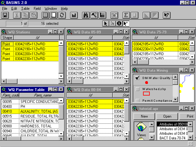
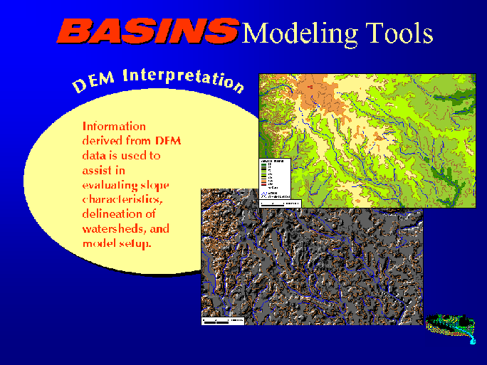
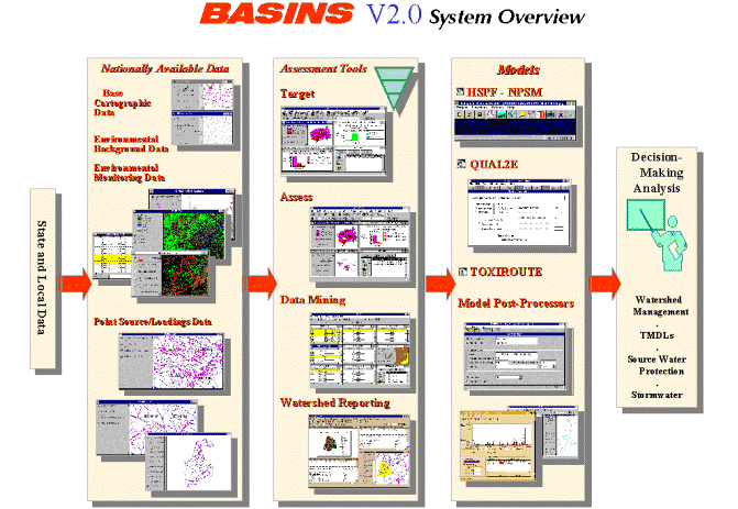
Three models are integrated into BASINS within an ArcView GIS environment. This allows the
user to assess watershed loadings and receiving water impacts at various levels of complexity.
ArcView geographic data preparation, selection routines, and visual output streamline the use of
the models. A post-processor graphically displays model results.
The Nonpoint Source Model (NPSM) estimates land-use-specific nonpoint source loadings for
selected pollutants at a watershed (cataloging unit or user-defined subwatershed scale). The
model uses landscape data such as watershed boundaries and land use distribution to
automatically prepare many of the input data it requires. NPSM combines a Windows-based
interface with EPA's Hydrologic Simulation Program-FORTRAN (HSPF) model, and is linked
to ArcView.
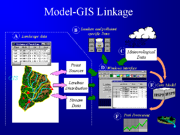
The NPSM also allows a user to simulate both the routing of flows and water quality behavior
through a connected network of reaches (this includes streams, rivers, lakes, and reservoirs).
The current version of the NPSM is specifically designed to work with RF-1, however, a user
may specify their own reach network or edit an existing RF-1 network from within the NPSM
user interface.
A user can also simulate point source contributions in HSPF via the NPSM. Using one of the
more advanced features in HSPF, the NPSM can now create an HSPF input file that can
simulate both point and nonpoint source contributions for an area of interest. This is a simplified
implementation in that only a single value of flow from the facility and pollutant concentration
(based on a NPDES permit limit) can be specified. Future enhancements will allow users to
simulate time varying flows and pollutant concentration.
QUAL2E model is a one-dimensional, steady-state water quality and eutrophication model. It is
integrated with ArcView through a Windows-based interface. It allows fate and transport
modeling for both point and nonpoint source loadings. Nonpoint source loadings can be
generated by HSPF and then fed into QUAL2E through an internal procedure.
TOXIROUTE is a screening-level stream routing model that performs simple dilution/decay
calculations under mean or low flow conditions for a stream system within a given watershed
(cataloging unit). TOXIROUTE can also integrate nonpoint source loadings calculated by
HSPF within ArcView, as well as point source loadings computed from the effluent monitoring
data.
Post Processing
The BASINS modeling system includes a post processing tool to facilitate the evaluation and
analysis of model output. The graphical interface allows the user to select data sets, parameters,
and location; define output scales; and overlay multiple graphs and management scenarios. The
post-processor makes it easier to compare model runs of HSPF with each other, and it can
incorporate monitoring data to make calibration easier. The post-processor can also incorporate
averaging periods, using arithmetic or geometric means, and can calculate the number of
exceedances of a user-defined threshold and an averaging period.

Minimum System Requirements
Table 2. BASINS Hardware and Software
Requirements
Hardware/Software |
|
Minimum Requirements |
|
Preferred Requirements |
| Processor |
|
133-Mhz Pentium Processor |
|
200-Mhz Pentium Processor |
| Available hard disk space |
|
For a single 8-digit watershed (cataloging unit), allow
for 150 mb (20 mb for BASINS system, 10 mb for temporary
file processing space, and 120 mb for BASINS Environmental
Data) |
|
540 mb (20 mb for BASINS system, 20 mb for temporary
file processing space, and 500 mb for BASINS Environmental
Data for approximately one state) |
| Random Access Memory (RAM) |
|
32 mb of RAM plus 32 mb of permanent virtual memory
swap space |
|
64 mb of RAM plus 64 mb of permanent virtual memory
swap space |
| Compact disc reader |
|
Quad speed reader (one-time use) |
|
24X reader (one-time use) |
| Color monitor |
|
Configured for 16 colors |
|
Configured for 256 colors |
| Operating System |
|
Windows 95, Windows NT* |
|
Windows 95,Windows NT* |
| ArcView |
|
ArcView, Version 3.0a and ArcView Dialog Designer |
|
ArcView, Version 3.0a and ArcView Dialog Designer |
*Except for QUAL2E model which is not ported yet in Windows NT
Example Applications
The BASINS system was applied to the evaluate the nonpoint source contribution in James
River Watershed, Virginia. This planning level application assisted in determining loadings
from various subwatersheds and in identifying priority areas. These loadings were used as input
to a 3-D hydrodynamic model of the estuarine portion of the river.

The BASINS system was also applied to evaluate bacteria loadings under time varying
conditions to provide the technical basis for the formulation of TMDLs in Georgia and West
Virginia. The evaluation of the source loading contributions and the resulting in-stream
concentrations of bacteria was necessary for the development of TMDLs for the selected high
priority waters.

Future Enhancements
BASINS version 2.1 will include an ArcView implementation of USDA's (Soil and Water Assessment Tool) SWAT model. The
ability to use USDA developed and supported modeling approaches in parallel with the EPA
and USGS supported HSPF model will increase the comfort level of the agricultural community
as we deal with nonpoint source dominated TMDLs.
BASINS version 3.0 (and beyond) will include a lake process model to deal with nutrient
problems such as eutrophication and various related end points. This model should be capable
of being configured in 1, 2, or 3-dimensions. The Environmental Fluid Dynamics Code (EFDC) is a candidate because it can be used for 2
or 3-D situations and for tidally reversing flow. EFDC is also being used to develop the
Sediment Modeling Toolkit which will be incorporated into BASINS in the future. A field scale
model is envisioned that will allow natural resource managers to explore the effects of specific
combinations of Best Management Practices (BMPs) and land management practices on
controlling NPS loadings to water bodies. In addition, the Cornell Mixing Zone Expert (CORMIX) model and
the Storm Water Management Model (SWMM) also may be added in future years to meet
identified needs of a broad user community.
Conclusions
The availability of analytical tools such as BASINS gives EPA and its state partners some level
of confidence that they will be able to meet the ominous task of developing TMDLs. Lessons
learned through the development process can be summarized as follows:
BASINS will make TMDL and watershed analysis easier, never easy - and perhaps more
interesting. There are enough data to begin the analysis, and over time data availability and
technical capability will improve.
References
BASINS 2.0 Users Manual
http://www.epa.gov/OST/BASINS
Andrew T. Battin
Russel Kinerson, Ph.D.
Office of Water, Office of Science and Technology
US Environmental Protection Agency
401 Mth Street SW
Washington, DC 20460
Tel. 202-260-3061 Fax. 202-260-9830
Email. battin.andrew@epamail.epa.gov
Email. kinerson.russel@epamail.epa.gov
Mohammed Lahlou, Ph.D.
Tetra Tech, Inc.
10306 Eaton Place, Suite 340
Fairfax, VA 22030
Tel. 703-385-6000 Fax. 703-385-6007
Email. lahlomo@tetratech-ffx.com