Conservation Site Selection: Ecoregional Planning for Biodiversity
Mark Anderson, Frank Biasi, and Steve Buttrick
ABSTRACT
This paper describes the approach used by The Nature Conservancy’s Eastern Regional Office to develop a strategic plan for conserving biodiversity in the Northern Appalachian-Boreal ecoregion. The methodology involves defining conservation targets, setting conservation goals and criteria, selecting sites, and evaluating sites. It relies heavily on GIS maps and analyses, a synthesis of expert knowledge, public datasets, and the new national vegetation classification system. It also utilizes a new spatial unit, termed an ecoblock, to select sites and form the basis of a multi-purpose ecological census for conservation planning.
INTRODUCTION
The mission of The Nature Conservancy (TNC) is to preserve the plants, animals, and natural communities that represent the diversity of life on Earth by protecting the lands and waters they need to survive. TNC manages the largest private system of nature sanctuaries in the world, with more than 1,600 preserves in the United States. Since 1953 it has protected 10 million acres in the U.S. and 60 million acres in Latin America, the Caribbean, and the South Pacific. TNC currently owns 1.5 million acres in fee or easement, on which it conducts a wide range of ecological management and research.
Historically TNC has conserved land through a somewhat opportunistic and state-by-state approach. Although the focus has always been on preserving good examples of rare and vulnerable species and communities (elements), TNC and others have realized that this approach has not and will not capture the full range of biodiversity threatened by human development. Loss of species and communities is increasing rapidly despite efforts by public and private conservation organizations. These disjointed "tactical" efforts have left many gaps in the element representation on protected lands. Moreover, inclusion within a small isolated conservation parcel does not ensure the permanent viability of an individual occurrence, much less an entire species or community type. It is now understood that conservation planning and action must be done at larger scales in order to preserve the landscape patterns and processes that these elements of biodiversity depend on.
With this understanding, and new theories on conservation biology, TNC is beginning to strategically redesign its preserve portfolio and think broadly about the entire portfolio of conservation and public lands in order to most efficiently preserve every species and community type. It is developing a strategic approach to biodiversity conservation which is focused on ecoregions rather than political jurisdictions. The overall goal is to assemble a portfolio of managed areas that represents and preserves the full biological diversity of every ecoregion. An ecoregion can be defined as an area of similar climate and vegetation. Each portfolio will contain multiple viable occurrences of all native species and community types, in sufficient number, distribution, and quality, to ensure the element’s existence and variablity within the ecoregion (Redford et al. 1997). The portfolio will not be limited to TNC properties, but will include land owned by other public and private entities. It will be based on an ecoregional assessment and plan which summarizes the current portfolio and outlines where and how land should be protected and managed to fill gaps in element representation and maintain the ecological integrity of the ecoregion.
This paper is intended to describe the approach being developed by TNC’s Eastern Regional Office to assemble an ecoregional portfolio of conservation sites. It relies heavily on GIS maps and analyses, a synthesis of expert knowledge, public datasets (especially Natural Heritage Network data), and the new national vegetation classification system (Grossman et. al. 1998; Anderson et. al, 1998). It also utilizes a new spatial unit, termed an ecoblock, to select sites and form the basis of a multi-purpose ecological census for conservation planning. The approach described here is a work in progress rather than a complete and tested methodology. The ecoregion of interest is the Northern Appalachian/Boreal ecoregion which includes 31 million acres of generally forested land in northern Maine, New Hampshire, Vermont, and New York. Our approach has benefited from extensive review, discussion, and modification by the Northern Appalachians Community Working Group made up of TNC and Natural Heritage Network ecologists (see Acknowledgements).
ECOREGION-BASED CONSERVATION
The process of assembling an ecoregional portfolio is complex, and it varies depending on the ecology and data available for a given ecoregion. There are pilot projects being conducted by several TNC offices, each of which is using a somewhat different approach to the process. However, they all have the following four steps in common:
This process is assumed to be iterative, with modifications to the portfolio being made as new information becomes available or sites are unable to be protected. Note that these steps do not include the related process of site conservation planning (a.k.a. site design) that defines the boundaries of each portfolio site and which areas within the site will receive various types of protection and management. It must also be noted that the portfolio we assembled depends on the ecoregion remaining in a generally forested condition, meaning that if the forest between the sites were destroyed or severely degraded, the sites would have to be much larger and the number of sites would have to increase substantially.
The first step in ecoregion-based conservation is to define exactly what we want to capture in the portfolio. If the overall goal is to represent all elements of biodiversity, then we must identify which species and habitat types occur in the ecoregion. Historically TNC and its partners have been good at identifying and tracking rare animal and plant species. Over the past 25 years TNC has worked with state, provincial, and federal agencies to establish a network of 82 Natural Heritage Programs and Conservation Data Centers throughout the western hemisphere. These groups inventory, map, and monitor threatened and endangered species and communities using a standard methodology and data structure. The Biological and Conservation Data System (BCD), includes both global information pertaining to an entire species or community type, as well as local information about specific occurrences of each element within a state or province.
Because of this database, TNC has a fairly good inventory of rare species, and to a lesser degree, rare communities. However, the goal of ecoregion-based conservation is to represent all native species and community types, including the common ones. Since it is difficult and expensive to develop a comprehensive inventory of common species, it was deemed appropriate to use natural communities as a "coarse filter" for capturing common species. This rationale assumes that if we capture good examples of all community types, we will also capture the common plant and animal species that depend on them. The coarse filter approach is a good complement to the "fine filter" strategy of protecting isolated occurrences of rare elements. Using this two-pronged approach, the complete target list for the ecoregion consisted of 125 natural community types, 30 imperiled plants, and 14 imperiled animals.
One difficulty with using communities as conservation targets is that, until recently, there was no standard classification system defining them. This led to communities being named and defined differently between states, with some types being lumped in one state and split in others. To resolve these discrepancies and allow data to be aggregated across states, TNC has developed a national community classification system, which is analogous to the species taxonomy (family/genus/species) used to classify organisms. This system defines hierarchical classes beginning with the community’s gross structure (e.g. forest, shrubland, grassland) and ending with its overstory and understory plant species composition (e.g. Maple-Beech-Birch/Hobblebush forest). The Federal Geographic Data Committee has designated it the official national vegetation classification system to be used by federal agencies for mapping and classifying vegetation (Grossman et. al. 1998; Anderson et. al, 1998).
Community targets were set at the association level of the hierarchy, which is defined by the overstory and understory species composition and environmental setting. The Heritage database contained 1087 occurrences of 125 associations. We also used 435 occurrences of 44 imperiled or threatened species as potential portfolio targets. Of the total 1,522 element occurrences, 878 were filtered out as not being viable examples on which to base the portfolio. Our methods for determining occurrence viability and setting representation goals are described below.
Step 2. Setting Conservation Goals and Criteria
Viability
Determining which occurrences should become the framework points for constructing a reserve portfolio is a central question in ecoregional planning. To protect conservation investments in sites, we must set criteria for what constitutes a "viable" occurrence of the element. Viability is defined as the ability of an element occurrence (EO) to persist over time. This means that the occurrence is in good condition and has sufficient size and resilience to survive occasional natural and human stresses. The predicted viability of a species or community occurrence is currently addressed through the development and application of element occurrence ranks (EO Ranks). As recently defined, EO Ranks are meant to provide a succinct assessment of estimated viability based on the occurrence’s size, condition, and landscape context (Element Occurrence Data Standards, Working Draft, February 5, 1997 The Nature Conservancy in cooperation with the Network of Natural Heritage Programs and Conservation Data Centers). These criteria apply to animal and plant species as well as communities, although they are assessed differently for each element type.
Size is a quantitative measure of the area and/or abundance of an occurrence. Components of this factor for species include area, population abundance, population density and area of occupancy, and population fluctuation (average population and minimum population in the worst foreseeable year). For communities size is simply a measure of the occurrence’s patch size.
Condition is an integrated measure of the quality of biotic and abiotic factors, structures, and processes within the occurrence, and the degree to which they affect the continued existence of the occurrence. For animal and plant species this includes reproduction (evidence of regular, successful reproduction; age distribution for long-lived species). For species and communities it includes species composition and biological structure (presence of exotics), ecological processes (changes in hydrology or natural fire regime, etc.), degree of human disturbance, and abiotic factors (stability of substrate, water quality, etc.).
Landscape context is an integrated measure of the quality of biotic and abiotic factors, structures, and processes surrounding the occurrence, and the degree to which they affect the continued existence of the occurrence. Components of this factor include landscape structure and extent (e.g. pattern, connectivity, measure of fragmentation/patchiness, measure of genetic connectivity) and condition of the surrounding landscape (i.e. development/maturity, species composition and biological structure, ecological processes, abiotic physical factors).
Under the new EO standards, size, condition, and landscape context are integrated to create the EO Rank, which is defined as follows:
A = excellent estimated viability
B = good estimated viability
C = fair estimated viability
D = poor estimated viability
These ranks are routinely assigned by the Network of Natural Heritage Programs, and updated and maintained in BCD. Appropriate thresholds for size, condition and landscape context vary for each element type, as defined by EO Rank specifications written by experts on each species or community. Over the years EO Rank specifications have been developed for rare species, allowing ranks to be objectively assigned to all species occurrences in BCD.
In general, however, EO Ranks have not yet been developed for natural communities. Until 1997 there was not even a standard taxonomic classification of communities, so no communities have written EO Rank specifications. Thus, few community occurrences have EO Ranks. Since occurrence viability is so important in developing a long-term portfolio, we found it necessary to develop interim specifications that could be applied to broad groups of communities. We determined that the most meaningful way to group communities for viability assessment should be based on the typical patch size in which they occur on the landscape.
Patch Size
Communities vary greatly in terms of their size of occurrence and ecological specificity, with some types covering huge areas of varying topography, geology, and hydrology, while others exist only in small patches under unique environmental conditions. Based on these qualities, we classified all communities into one of three types, referred to as matrix, large patch and small patch. Matrix (or dominant), communities form extensive cover, often blanketing 80% of the undeveloped land, and covering 100 to 1 million contiguous acres. These types have broad ecological amplitude and are driven by regional scale processes. They are important as coarse filters for wide ranging fauna such as large herbivores, predators, forest interior, and migratory birds. Examples include Red Spruce-Balsam Fir forests and Maple-Beech-Birch Northern Hardwood forest.
Nested within the matrix forests are smaller scale "patch" communities with more specific ecological amplitudes and often more restricted species. Large patch communities may form extensive cover, up to 1,000 acres in some places, but usually their boundaries are correlated with a single dominant local process such as hydrology or fire regime. These communities often have a set of characteristic fauna associated with them, and likely serve as resource patches for fauna associated with the matrix communities. Examples include Red Maple-Black Ash swamps, Rich Northern Hardwood forests, and Black Spruce bogs.
Even more restricted are small patch communities which have very specific ecological amplitudes and occur where a number of local conditions come together in a precise way. Although their boundaries are often easy to delineate, these community types are inextricably linked to the landscapes in which they occur. Thus they may not be viable over the long term without preservation of the larger system in which they are embedded. Small patch communities often occur in stressful or unusual conditions, serving as refuges for species which are poor competitors (including many rare species). They also serve as a coarse filter for a very specific invertebrate fauna. Examples in the Northern Appalachians include Slender Sedge fen, Acidic Rocky summit, and Calcareous cliff.
Of the roughly 105 community associations in the northern Appalachians, about 5% are matrix types, 40% are large patch types and 55% are small patch types. If we consider the communities relatively equal in biodiversity value then clearly most of the biodiversity of the ecoregion is concentrated in the patch communities making them natural targets for reserve selection. However with regard to land cover, the 4 matrix forests likely cover close to 75% of the remaining natural landscape, while the large patch may cover an estimated 20%, and the small patch communities probably cover less than 5% of the landscape. Clearly the matrix types are important targets for the maintenance of the biological integrity and fundamental structure of the region. Note also that most matrix and some large patch communities are mainly threatened by degradation and fragmentation while small patch communities are generally more susceptible to the hazards of rarity. Thus the different occurrence types call for different viability criteria and conservation strategies.
Community Viability
Classifying community types by patch size enabled us to set reasonable thresholds for the size, condition and landscape context of viable occurrences. The relative weights of these criteria differed based on whether the community was a matrix, large or small patch type. In addition to being stable, persistent and resilient over time, our coarse/fine filter strategy makes it necessary for community occurrences to be functional as coarse filters for all associated common and uncommon species. By maximizing our viability thresholds we believed we could achieve both goals. The thresholds we set and their justifications are described below.
A. Size
The size of an occurrence is fundamental in determining both 1) the stability and resilience of the community occurrence and 2) the diversity of species within the occurrence (both component plant species and all associated faunal species). The theoretical reasoning behind this is relatively straightforward although the actual acreage needs are still somewhat elusive
A1. Size effects on Stability, Persistence and Resilience
Essentially communities are dynamic systems driven by the demographics of the component species. For the communities to persist over time and space, the species within it must find adequate resources for consumption and have adequate area to establish, reproduce, disperse and die. As these functions require area, the stability and resilience of an occurrence increases with size.
For matrix forming communities the concept of minimum dynamic area (Pickett and Thompson 1978) is useful for referencing the area needed to maintain the internal dynamics of the system. In the N. Appalachian ecoregion these processes include single tree gap replacement, shifts in successional states following natural catastrophic disturbances, or larger scale mortality caused by chronic stress (including pollution and degradation). Major stress and disturbance factors in this region include hurricanes, insect outbreaks, disease, fire and acid rain. These may range in effect from less than an acre to over 5 million acres (Stevens 1996, Mello 1987).
For patch communities, which occur in a more discrete and scattered way a metapopulation model is more useful in thinking about long term persistence. The focus then becomes identifying which occurrences are sources (Pulliam 1988) e.g. good habitat where local reproductive success is greater than local mortality and the occurrence may be a source of emigrating propagules, and which occurrences are sinks e.g. poorer habitats with populations maintained from immigrating sources. We assumed that occurrences that are large and in good condition are generally sources.
A2. Size effects on Diversity
Large occurrences are generally more diverse in associated species for several reasons. Firstly large occurrences are often correlated with more landscape diversity, more available habitats and microhabitats (patch communities), and more internal variation within the community itself. Secondly, and especially for matrix communities, the larger the occurrence the more likely it is to be utilized by area-sensitive species. This includes species with very large home ranges, such as large predators with territories defined by the abundance of prey species. Small home range species often avoid small occurrences of forest also as they are more vulnerable to predation or parasatism by edge related predators. Additionally many small home range species are loosely colonial and prefer to inhabit patches of habitat which contain other members of their species. Thirdly although many small occurrences may provide enough area for the day to day movements of many species, seasonal movements such as migrations or, more importantly, dispersal by juveniles or seeds may become restricted within small occurrences and ultimately isolate the population. Lastly low density populations may be absent from small occurrences by chance alone, as the probability of the species encountering the patch decreases, the smaller and more isolated the occurrence is. As our coarse filter target implies both the common and uncommon species, this last point is reason enough to be cautious about small isolated occurrences as a central point for building a portfolio.
Solution (Table 2): Based on the above reasoning and examples we set the following size minimums for primary occurrences in the Northern Appalachian /Boreal ecoregion:
|
PATCH TYPE |
MINIMUM SIZE (acres) |
|||
|
Forest |
Woodland |
Shrub |
Herbaceous |
|
|
Large Patch |
100 |
100 |
50 |
50 |
|
Small Patch |
20 |
10 |
5 |
1 |
|
Matrix |
25,000 acres (assumes a mosaic of matrix forest types) |
|||
The size of a community occurrence is a standard field in the Heritage element occurrence database. However, since there were few records of matrix communities in BCD and since good matrix occurrences should be contiguous, we used block size as a surrogate. Blocks are contiguous areas bounded by roads, powerlines, and shorelines.
B. Condition
A variety of observable features affect the condition of an element occurrence, primary among them are fragmentation, invasion by exotics, anthropogenic manipulation of the occurrence (e.g. cutting, grazing, mowing), poor habitat quality, and subsequent poor development of the community. These factors are quite interrelated although they are discussed separately below.
Fragmentation: Forman (in Hunter 1996) has described the overall process of fragmentation as having four phases 1) dissection of an area by roads or other fragmenting features, 2) perforation of the area by conversion of pieces of the natural system to agriculture, developed land or clearcut, 3) fragmentation as the perforation stages grows more extensive and pieces of the natural systems become isolated from one another and 4) attrition where the new "matrix" of converted features comes to dominate the area in terms of extent and connectivity. Although we evaluate an occurrence based on its current state, fragmentation is a dynamic process and its current state may indicate position along this trajectory.
A major issue in measuring the fragmentation of a matrix (or any) community occurrence was determining which features: highways, dirt roads, powerlines, railroads, trails, etc. are fragmenting and which are not. Evidence is accumulating to suggest that virtually all of the features listed are fragmenting to some species and some populations. It is perhaps easier to conceive of the cumulative effect of a variety of fragmenting features as a filter for certain species. Species which are disproportionally affected by fragmentation include those that are naturally rare and occur in small, low-density populations, those that have low reproductive rates and are slow to recover from a disturbance, those that are poor dispersers, those that are wide ranging and require a lot of contiguous cover and, those that are dependent on unpredictable or patchy resources (Meffe & Carroll 1994).
A second effect of fragmentation is an increase in "edge" in relation to total area. This is a problem because the conditions on the edge are often quite different than in the interior of a community. Typically edge habitats have increased solar radiation, wind desiccation, and evaporation rates. Subsequently tree mortality is higher on the edge leading to expansion of the edge habitat over time. Edge habitat often provides access into a community by small predators and brood parasites such as foxes, skunks, raccoons and cowbirds which can be particularly destructive to ground nesting or interior nesting birds. Additionally the edge conditions often provide routes for certain exotic species which may displace or compete with native species. The negative effects of edge habitat has been a major contributor to the corridors controversy as long narrow corridors connecting sites together effectively increase the amount of edge habitat.
Multigenerational Features, Biological Legacies and Reservoirs:
A second measure of condition is the evaluation of an occurrence for features which take multiple generations to develop. In forests, for example, these may include the presence of: 1) fallen logs and rotting wood , 2) a well developed moss/herbaceous understory, 3) structural complexity in the canopy and understory layers, 4) a reservoir of soil organic matter for nutrient storage, 5) seed banks, and 6) redundancies that stabilize critical cycles (e.g. nutrient cycles, micorrhizal interactions and pollination/dispersal vectors). In forested systems, often the single best predictor of these features is the presence of old trees (e.g."old growth") however the development of many of these features may take considerably longer than the life span of a single cohort of trees (sometimes hundreds to thousands of years). As very few current restoration efforts can guarantee success over such long time frames it is crucial to identify and target these occurrences for conservation action.
Solution:
We evaluated condition differently for matrix and patch communities.
For each potential matrix block we rated the block as high, medium, or low in terms of the following attributes:
1) Roadedness
2) Current forest condition (including cutting history, % land in clear cut, agriculture or development)
3) Amount and extent of old growth
4) Condition of the lakes and ponds when known
For patch communities we ranked each occurrence on a simple 3 point scale:
1 = high, no signs of anthropogenic disturbance, no exotics, no obvious fragmenting features.
2 = moderate, some signs of anthropogenic disturbance, exotics, some fragmenting features.
3 = poor, obvious signs of anthropogenic disturbance, lots of exotics, obvious fragmenting features.
Old Growth:
We also had a flag for certain patch types to indicate that the occurrence represented an old growth site (defined here as having trees 180 years old or greater).
C. Landscape Context
Surrounding is particularly an issue for the patch community types and rare species. For these targets, the presence of the occurrence in the landscape often indicates a particular intersection of environmental features such as local hydrology, water chemistry, local disturbance regime, bedrock type, and available propagule sources. Alteration of any of these features, most of which are maintained by processes outside the actual occurrence, may result in loss of the occurrence at the site. This concept is well understood by many applied ecologists who have observed the degradation and disappearance of many interesting community occurrences when fire regimes were altered (e.g. pine barrens), the surrounding hydrology was interrupted (e.g. fens and pond shores), water chemistry was altered from agricultural runoff (e.g. freshwater wetlands and ponds) , seasonal disturbance regimes were altered (e.g. rivershore grasslands and ice-scour communities) and even when contact with bedrock was prevented by the invasion and subsequent litter fall of a new species (e.g. serpentine barrens and Pinus virginiana). Wetland, floodplain and other lowland communities are particularly susceptible to this as lowland features tend to accumulate, concentrate and depend on materials from outside their own systems. Conversely, high elevation or locally elevated features may be more isolated and thus more tolerant of degradation or changes in the surrounding landscape.
Solution: For each occurrence we ranked the quality of the 1000 acres surrounding it on a 1-4 scale:
1 - surrounded by 1000+ acres of intact matrix or large patch communities
2 - surrounded by forest or undisturbed communities but may have developed land or clearcutting nearby
3 - surrounded by fragmented forest, agricultural land or rural development
4 - surrounding area intensely developed
When the condition of the landscape was unknown we approximated it by examining the size of the surrounding block (see below) which contained the occurrence. We used the assumption that if the occurrence was contained in a block less than 1000 acres there was reason to be skeptical of its long term persistence. Additionally we assumed that if the occurrence fell within a selected matrix site its landscape condition was probably good. We also examined the spatial patterns of the patch community occurrences to identify concentrations of good (primary target) occurrences. These concentration areas likely indicate areas with intact large scale landscape processes suggesting that we adopt a mega-site or matrix-like approach to conservation in these areas.
D. Synthesis Of The Criteria
For patch communities, four possible combinations of landscape context, current condition and size were used to identify primary target occurrences (Table 3). First we systematically and objectively applied the criteria to all occurrences in the database, then we reviewed the results in detail with state Heritage ecologists and TNC staff during a series of state by state meetings. During this review process approximately 15% of occurrences were included or precluded as primary targets based on further information about the occurrence. The condition combinations were intended to maximize the probability that the occurrence was viable, functional as a coarse filter, and was associated with a reasonably intact site.
Table 3. Acceptable criteria combinations for community occurrences in the Northern Appalachian/Boreal Ecoregion. For example: for large patch forest communities, an occurrence was included as a primary target if its condition was 1, landscape context was 1, and its size was greater than 100 acres. However, if its landscape context was 3 then its condition had to be 1 and its size had to be greater than 200 acres. Matrix types had to be greater than 25,000 ac. in all cases, with condition of 1, but landscape context could be 2.
|
Viability Criteria Combination |
Landscape Quality (1-4) |
Current condition (1-3) |
Size: Large Patch (acres) |
Size: Small Patch (acres) |
||||
|
Forest / Woodland |
Shrub / Herbaceous |
Forest |
Woodland |
Shrub |
Herb. |
|||
|
Combination 1 |
1 |
1 |
100 |
50 |
20 |
10 |
5 |
1 |
|
Combination 2 |
2 |
1 |
100 |
50 |
20 |
10 |
5 |
1 |
|
Combination 3 |
1 |
2 |
100 |
50 |
20 |
10 |
5 |
1 |
|
Combination 4 |
1 |
3 |
200 |
100 |
50 |
50 |
10 |
10 |
|
Matrix types |
1 |
1 or 2 |
25,000 with at least 50 acres of old growth |
|||||
Stratification of the Ecoregion and occurrence placement
Once we decided which elements to target and what qualified as a viable occurrences, we had to decide how many occurrences were needed to preserve the element in the ecoregion, and what spatial stratification was necessary to represent its environmental and genetic variation. We determined that the number of occurrences should be driven by the spatial representation goals for each element. To determine the proper placement and distribution of occurrences it was necessary to first examine the patterns of ecological and species diversity within the ecoregion. In particular, identifying what the major ecological gradients are and how they are distributed across the landscape is useful in thinking about placement of a reserve system. Using maps and discussion, we examined patterns of elevation, climate, soil types, topographic diversity, bedrock types, maritime influence, disturbance regimes, land use, and community distribution.
We found the US Forest Service subsections (Keys et.al. 1996) to be a good unit for representing variations in environmental gradients and community distributions. To make the subsections more useful as a stratification tool we developed a hierarchical model partitioning the ecoregion into increasingly finer units using the same methodology and data we used to define the ecoregion itself (Table 4). In general, the ecoregions, subregions and sections represent statistical clusters of USFS subsections, that are more related to each other in terms of community types than to other subsections. This was based on community/subsection intersection tables developed by TNC and Heritage ecologists for the US Forest Service.
Table 4. Stepwise stratification of the USFS subsections
|
Northern Appalachian-Boreal Ecoregion |
|||||||
|
Northern Appalachian Mountains |
Boreal Hills and Lowlands |
||||||
|
Adirondacks & Tughill |
White & Green Mts. |
Northern Boreal Hills |
Southern Boreal Hills |
||||
|
Tughill M212Fa-b |
Adirondacks M212Da-f |
White Mts. M212Ac-g |
Green Mts. M212Ba M212Ca,d |
St. John Upland M212Aa-b |
Aroostook- New Brunswick 212Aa-b |
Fundy Coastal & Interior 212Ba-b |
Central ME Embayment 212Ca-b 212Da |
To set spatial representation goals for community occurrences we overlaid the estimated subsection distribution of the community on the hierarchical model of ecoregion gradients, and examined the intersection of community distribution and ecoregion gradients. The hierarchical nature of the model allowed us to stratify some community types more finely (the restricted and limited types - see below) and others more coarsely (widespread and peripheral types).
Distribution and Restrictedness
Because of the variation in occurrence size, how characteristic a community is of an ecoregion is not a function of its dominance or abundance within the ecoregion but rather of its restrictedness and fidelity to that ecoregion. To gauge how many occurrences of each community we wanted to protect, and how intensively we needed to stratify their distribution, we grouped the communities into four groups based on the relative restrictedness of the element to the ecoregion. Communities which were restricted (endemic) to the ecoregion, and thus depend entirely on protection efforts within the ecoregion for long term conservation, were allotted more occurrences and these were stratified more rigorously with regard to spatial distribution. Conversely, widespread occurrences which will ultimately be conserved by a group of ecoregions acting in concert were allotted less occurrences within the ecoregion and these were stratified less rigorously. Ultimately stratification of widespread communities will be based on a multi-ecoregion stratification scheme.
We examined the distribution of each community across the entire region and country basing at least part of our analysis on community by subsection maps. We assigned each community association to one of four common distribution patterns relative to the Northern Appalachian/Boreal ecoregion: Restricted (e.g. the community occurs only within the ecoregion), Limited (the community typically occurs within the region but also occurs in a few adjacent regions), Widespread (the community is typical of the ecoregion but also occurs in most other ecoregions, and Peripheral (the community does occur within the ecoregion but the core of its distribution is within another ecoregion). Our information was supplemented with range maps of the dominant species or key indicator species, and maps of associated habitat features such as particular bedrock types, climatic isoclines, distribution of high elevation summits, etc..
Synthesis: Setting benchmark amounts
To set benchmark levels for amount and stratification of community occurrences we begin by discussing the dynamics of a hypothetical restricted small patch community which occurred throughout the ecoregion. First we decided that as a bare minimum we would need some occurrences in each of the 4 major subregions to insure representation of the internal and landscape context variability of the type, buffer against degradation in one subregion or another, and to allow for possible geographic range shifts over time (Hunter 1996). Thus we set the minimum stratification level for a restricted community at 4 (meaning we wanted some occurrences in each of the four subregions). Next we assumed that at least a handful of source occurrences in each subregion (which are roughly 8 million acres each) would be necessary to insure some communication between occurrences as well as buffer against the effects of chance events which might unexpectedly eliminate certain occurrences. Thus we set a bare minimum of 5 occurrences per subregion, which totals 20 occurrences for the ecoregion stratified into 4 subregions which we adopted as a reasonable minimum benchmark for the type. From this number we worked backwards to the other types decreasing the amounts and stratification levels for the larger and less restricted community types (Table 5).
Our final set of numbers represent the Minimum Conservation Benchmark for each community type. Attempting to meet these benchmarks will provide us with a solid twenty years of conservation effort and should stimulate some excellent inventory, protection work and partnerships. However, we do not know if they are truly adequate to preserve biodiversity in the ecoregion. We are in relative agreement about one point: that these numbers are not likely to decrease and are very likely to need upward revision as the future unfolds.
To some extent these benchmarks might be thought of as an "equation" of which the actual portfolio is the "solution". Note, that there may be many acceptable portfolios that provide adequate solutions to the equation. The actual location of the reserve sites is fixed only by the availability and location of target element occurrences from matrix to small patch to species. The minimum conservation benchmarks also allow us to systematically assess, for any version of the portfolio, the degree to which it meets the goals. This is discussed further under the heading Evaluating the Portfolio.
The sub-selection and exact spatial arrangement of the primary target element occurrences (PTEOs) is left to the understanding and judgment of the state Heritage Programs, TNC Field Offices, and other partners. Hopefully this will stimulate experimentation and maintain flexibility. Several theoretical approaches to finer-scale arrangement of the target EOs were discussed including:
These issues, while interesting, are, at this stage, mainly theoretical as for most communities we do not have enough primary target occurrences available to meet our goals in each subregion, let alone to sub-select from. Additionally primary target occurrences which are already protected or primary target patch occurrences which nest within matrix or other larger sites are already preselected for inclusion. Thus at this stage of development we are rather limited in our ability to arrange the occurrences into idealized configurations. For the purposes of the current portfolio all primary target occurrences are selected whether part of a matrix site, a cluster of patch sites, or on its own with a 1000 acre buffer surrounding it. Some plans for additional analyses and a second iteration of the portfolio are described below under Next Steps.
Summary - Our general model for setting community conservation goals (Table 5) was:
Table 5. Minimum conservation benchmarks for communities as a function of patch size and restrictedness.
|
Minimum stratification level |
Minimum primary target occurrences per subregion |
||
|
Matrix 2 |
Large Patch 4 |
Small Patch 5 |
|
|
Restricted 4 |
8 |
16 |
20 |
|
Limited 2 |
4 |
8 |
10 |
|
Widespread 1 |
2 |
4 |
5 |
|
Peripheral 1 |
2 |
4 |
5 |
Conservation Goals for Species
As was noted above, the viability of species occurrences was known through Heritage-assigned EO Ranks. Thus we were able to eliminate all D-ranked occurrences as being nonviable. The question of how many occurrences to protect should be applied over the species range, but rangewide occurrence data is difficult to assemble. In general, the more common a species is, the more likely it is to be protected through the adequate conservation of plant communities (the coarse filter). The rarer a species is the greater the need to target individual occurrences. Using this line of reasoning we decided that for the most imperiled species (ranked G1 by the Network of Natural Heritage Programs), the conservation goal should be the protection of all occurrences with an estimated viability of fair or better (occurrences with an EO Rank of A, B or C). For G2 species the goal should be the protection of all A and B ranked occurrences, and for G3s, all A ranked occurrences. The coarse filter of communities was used to capture G4 and G5 species, except in the case of certain G4 endemics, declining species, or disjunct populations that are on the edge of their range. Table 6 summarizes our conservation goals for species occurrences.
Table 6. Conservation goals for species based on rarity (Element rank) and viability (EO Rank)
|
Element Rank |
Target occurrences |
|
G1 - Imperiled |
all A, B, and C occurrences |
|
G2 - Threatened |
all A and B occurrences |
|
G3 - Rare |
all A occurrences |
|
G4 - Widespread |
case by case decisions (endemics, disjuncts, rapidly declining species etc.) and/or protect through community conservation |
|
G5 - Common |
protect through community conservation |
We decided to make subsections the geographic filter by which we will capture genetic and ecological variability. To do this we need to add to these goals the necessity of conserving at least one viable occurrence of each imperiled species in each subsection where it occurs. This means that for G2 elements C-ranked occurrences would be targeted if they were the best occurrences in a subsection. Similarly, for G3 elements B-ranked occurrences would be targeted if they were the best occurrences in a subsection and if there are no Bs, than Cs would be targeted.
The goals for G1-G3 species are considered minimum conservation benchmarks. These goals are likely to be modified as rangewide assessments are done. Goals will also be modified based on the number and distribution of A and B ranked occurrences. For instance, if a G2 species has very few A or B occurrences, the planning team might decide that more C ranked occurrences than one per subsection should be targeted.
Often, G3 elements are not tracked within a state. If that is the case, the goal remains the same but the target becomes the community type(s) that these species occur in and not the species themselves. After a portfolio has been developed, the sites should be evaluated to see if they meet all the goals for G1, G2 and G3 elements. Inventory will probably be necessary in order to validate whether goals for G3 species have been met.
Step 3. Selecting Sites
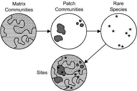
The three occurrence types typically nest and interdigitate to form complex mosaics reflecting the environmental heterogeneity of the landscape. Thus virtually all sites are mosaics of community types. Perhaps the ideal reserve consists of a large, viable example of matrix forest communities embedded with many interesting large and small patch communities and rare species occurrences (Figure 1).
Figure 1. The ideal conservation site consists of a mosaic of matrix, large and small patch communities, and rare species occurrences.
In reality, not all types of patch communities or species are found within the large matrix sites. Thus we needed to develop reserves at a variety of scales, some targeting matrix communities and others targeting patch communities not accounted for by the matrix sites. Because sites needed to represent matrix communties are much larger than those needed to preserve patch and species targets, and because good matrix sites will also include many of the smaller targets, it made sense to begin portfolio assembly by selecting matrix sites, and to conduct a "sweep analysis" to see what other targets were captured.
Selecting Matrix Sites
The backbone of the proposed reserve system consists of a network of large reserves targeting the matrix forest communities and selected to meet the following three criteria:
To assess this we assembled and integrated a variety of GIS datalayers and developed a series of 8 x 6 foot wall maps of the ecoregion at 1:320,000 scale. We then conducted a series of interviews with state Heritage ecologists and appropriate TNC field office staff to evaluate and discuss each potential matrix site. The datalayers consisted of:
We analyzed the information in a series of joint Heritage/TNC meetings performed state-by-state. Using a wide variety of paper maps, atlases, imagery, and reports we looked at every block larger than 25,000 acres and assessed the boundaries and interior roads to determine if they were truly barriers. Based on these assessments and field knowledge we split or aggregated blocks to form a draft site boundary (mega-block). We then compiled the following attributes for each site based on expert opinion and data analysis. Note that these attributes are a rudimentary version of the full ecoblock model that we are in the process of developing, which is outlined in Table 6.
Identifiers:
Block name
Block ID
Subsection
Subregion
Size:
Condition:
General condition of forest including amount of clear cut, agriculture and developed land
Roadedness, amount and type of dangling inroads
Roadedness rank (high-medium-low)
Diversity:
Other potential element occurrences
Amount of upland diversity (high-medium-low)
Amount of wetland diversity (high-medium-low)
Geologic features of note
Types and condition of lakes
Known conservation sites
Amount of Managed area
At this point our purpose was not to collect truly objective and comparable data on each block but to review the blocks systematically using the available experts, maps, and reports to produce a final potential site rating for each block. Blocks were ranked into 5 categories Yes (meets all the criteria), Maybe Yes, Maybe, Maybe No, and No. The Yes blocks were selected as the matrix sites for the first iteration of the portfolio.
Selecting Species and Patch Community Sites
All primary target occurrences which were not contained within the matrix sites were given their own portfolio sites. If a TNC site design had already been developed for the target occurrence then we adopted it as the default portfolio site. Other sites were simply identified as needing a site design over the next year. Clusters of sites, particularly those within a 1000 acre proximity of each other will be reassessed as larger scale mega-sites. When all sites and target occurrences had been identified the complete portfolio was measured against the conservation goals set for each species and community.
Selection Results
A total of 63 potential matrix blocks were evaluated, representing blocks larger than 25,000 acres and containing known EOs. Of these, 30 were identified as meeting the criteria, an additional 12 were considered "maybe-yes", and 8 more were ranked as "maybes". The rest were ruled out as not meeting the criteria. The 30 matrix sites total a little over 2 million acres in size, accounting for about 7% of the 31 million acre ecoregion. Collectively they contain about 43% of all the primary target occurrences. The other 57% of the primary target occurrences fall within 230 existing conservation sites (of which TNC managed areas and private reserves account for 20). Over 50% of the selected matrix block area falls within existing managed areas. Thus, influencing land management will be an important conservation strategy.
Step 4. Evaluating the Portfolio
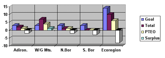
A complete evaluation of the first iteration portfolio towards meeting our conservation goals is not yet complete for every element. The assessment is relatively straightforward as explained here for one community, Red spruce-balsam fir/snowberry swamps (Picea rubens-Abies balsamea /gaultheria hispidula/sphagnum forest )red spruce-balsam fir swamps - Fig 2) This is a restricted large patch community which occurs throughout the ecoregion . A target goal of 3 occurrences was set each subregion with 2 more occurrences being reserved for unrestricted placement. This adds to a total of 14 for the ecoregion. In the White and Green mountain region a total of 7 occurrences are known of which 4 meet the PTEO criteria, thus there is a surplus of one EO in that region. In the Adirondacks a total of 2 occurrences were known of which 1 met the PTEO criteria leaving a deficit of 1 in that region. In the Northern Boreal Hills a total of 1 was known and it met the PTEO criteria leaving a deficit of 1. In the Southern Boreal Hills there were no known EOs although the community does occur there. If one of the unrestricted EOs is allocated to the White/Green Mt. subregion than the total for the ecoregion equals 6 leaving a deficit of 8 occurrences. Thus we have inventory needs in the Adirondacks, N. and S. Boreal Hills, but inventory of spruce-fir swamps is adequate in the White/Green Mt. subregion
Figure 2. Evaluation of the Oct. 31,1997 NAP portfolio towards the protection of Red spruce-Balsam Fir / Snowberry Swamps. The community is a restricted, large patch community. For each subregion the Goal column represents the conservation goal for the subregion. The Total column represents the current inventory total, the PTEO column indicates the number of element occurrences which meet the primary target occurrence criteria and the Surplus column represents the surplus or deficit between the goal and the available PTEOs.
Despite the fact that the portfolio does not come close to reaching our representation goals for most elements, it identifies plenty of areas in which to focus our work over the coming years. In addition to further inventory, this work will include a conservation feasibility assessment and site design for each portfolio site. It will also involve the analysis of potential corridors to provide ecological connectivity between sites. In developing the portfolio we came to realize that there are many parts of the ecoregion about which we know very little. Even within the selected blocks there are likely to be potential target occurrences which we are unaware of. There are likely to be better occurrences of some elements than are currently inventoried. We will identify new occurrences through field and aerial reconnaissance, photo and video interpretation, as well as predictive vegetation modeling. Additional plans for filling knowledge gaps and refining the portfolio are described below.
NEXT STEPS:
As the above methodology makes clear, we relied heavily on existing databases and expert opinion to assemble the portfolio. A lack of data content and quality and a short time-frame prevented us from conducting more sophisticated and objective GIS analyses. However, as we are evaluating the first iteration of the portfolio, we are beginning to collect new data and design analyses that will greatly inform the next iteration. Our plan is to fill in data gaps and to develop the Blocks coverage into an Ecoblocks coverage that contains extensive ecological attributes for every block, not just those greater than 25,000 acres. This coverage will represent an ecological census of the entire ecoregion which can be used to assess, select, and compare potential conservation sites and corridors, and to target areas for Heritage field inventory. It will also allow us conduct rapid ecological assessments of parcels that come onto the market to determine whether they fit into the existing portfolio, or possibly warrant revising the portfolio to incorporate them.
We will apply many of the attributes and criteria we used for communities to ecoblocks. Using blocks as a sampling unit, we will develop the following indices for every block in the ecoregion – Size, Condition, Diversity, and Landscape Context. These indices will be based on a variety of attributes derived from GIS analyses (Table 6). Classified satellite imagery, the 90 meter DEM, and the blocks coverage itself will be used to derive new datasets (e.g. developed land, slope position, interior forest), which will be summarized for each block. The ecoblock coverage will also contain lakes and major river polygons with relevant aquatic attributes, such as water quality, amount of undeveloped shoreline, stocking history, etc.. Proximities and adjacencies between ecoblocks will be used to select and group blocks into sites and corridors. Potential corridors can also be identified by intersecting blocks with streams and ridgelines.
Table 6. Potential ecoblock indices, attributes, and values used for conservation site selection.
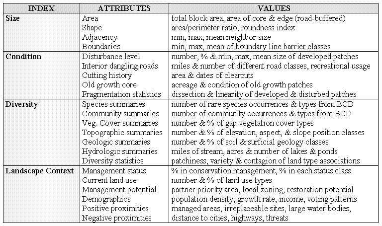
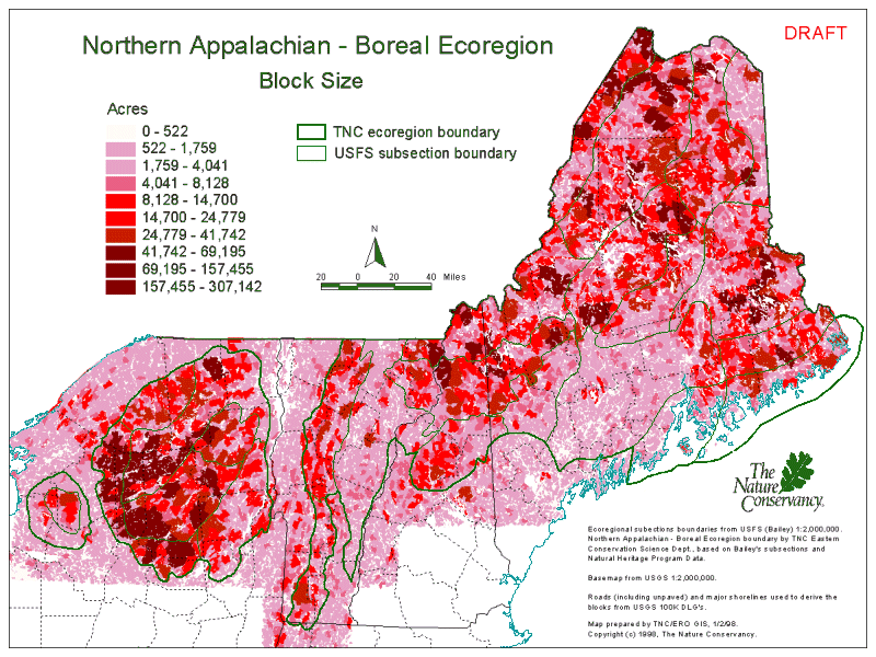
The Size index will be based on total area (Figure. 3) as well as the areas of core and edge polygons derived by buffering roads based on class. Shape, adjacent block sizes, and surrounding road classes will also factor into the Size index. Condition will be based on the amount and distribution of developed and disturbed land and roads within each block. The Diversity index is determined by the amount of biological, topographical, hydrological, and geological diversity that falls within the block. Landscape Context incorporates current and potential protection status, land use, and human demographics, as well as positive and negative proximities. Varying weights will be applied to these criteria to target specific elements or emphasize different portfolio development strategies (i.e. size vs. condition, clustered vs. dispersed). In order to compare blocks of varying sizes, many of the values listed in Table 6 must be represented as ranks or normalized values rather than absolute numbers. Much trial and error is still needed to define appropriate values for each of these attributes to allow them to roll-up into composite indices. However, the basic framework is in place and we will experiment with alternative values, attributes, and indices.
The core concept is that humans have altered the landscape dramatically, and that block boundaries and attributes provide a useful way of assessing the ecological importance of what natural areas remain. Other conservation site selection projects have used watersheds, regular grids, or political jurisdictions as sampling and selection units. However, watersheds are not directly applicable to terrestrial elements, and grids and political boundaries have no ecological significance. None of these other units bring us close to conservation site, parcel, or zoning boundaries, as blocks do. Moreover, ecoblocks place appropriate emphasis on the impact that humans have on biodiversity.
Figure 3. Map showing ecoblocks displayed by size. These blocks are defined by roads (including unpaved), powerlines, and major shorelines (river and lake polygons) from USGS 1:100,000 Digital Line Graphs (DLG).
Some other advantages of ecoblocks are as follows. They are discrete, objectively defined features which are ecologically meaningful units for conservation planning. They are easily recognizable to staff, decisionmakers, and the public. They are based on easily accessible public data, which are updated regularly by various organizations. They are an efficient unit for a biological census because they are easy to locate in the field. Similarly, they are easy to register with remotely sensed data since a basemap of roads and hydrography is built into the coverage. They are well correlated with parcel, zoning, census, and conservation site boundaries making them good surrogates for sites. In contrast to watersheds, blocks contain rather than divide peaks and ridges, allowing these features to be treated as whole units. Blocks also have meaningful area and boundary attributes such as size, shape, road widths and traffic volumes. They can be heirarchically nested based on road class, and they can be used effectively at local and regional scales. It is also useful to evaluate how ecoblock attributes change based on plans for the construction of new roads and powerlines or the closing of existing roads.
Ecoblocks also have limitations for conservation site selection. Although they include lake and river polygons, which hold different attributes than land blocks, they do not work as well for aquatic elements as for terrestrial ones. For this reason we intend to develop a parallel census of watersheds using similar indices and attributes meaningful for aquatic elements. Ecoblocks also tend to highlight mountainous areas, which are difficult to develop and are often already in conservation. Thus it is necessary to have representation goals and perhaps lower criteria for lowland areas. Another limitation of ecoblocks is that they require periodic revisions as roads and powerlines are built or abandoned. However, this provides useful information about landscape changes. The wide variation in block size also makes it difficult to compare blocks unless attributes are normalized by block area. Blocks coverages can also require substantial editing to close polygons caused by roads that do not edgematch or stop short of waterbodies. Some of this editing can be done through semi-automated snap and extend operations. Additional editing is also needed to correct misclassified roads and trails.
Despite the limitations, ecoblocks have proven to be useful units for conservation site selection, which deserve further research and application. We will be developing and applying them from the beginning in assembling a portfolio for the Central Appalachian ecoregion of Virginia, West Virginia, Maryland, and Pennsylvania. There we will also test the use of automated site selection algorithms in comparison to an expert-derived portfolio.
CONCLUSION
There are many possible approaches to assembling an ecoregional portfolio, all of which require an extensive database of element occurrences or meaningful surrogates. TNC is using a coarse-filter/fine-filter approach that targets all native species and communities found within each ecoregion. We have classified communities based on species composition, patch size and restrictedness, and we have set clear goals for amounts and spatial distribution of every element, as well as criteria for what constitutes a viable occurrence. Sites for matrix communities were selected first, using blocks as surrogate features. Ecological attributes were developed for large blocks based on expert interviews and data analysis. Matrix sites were selected interactively from the set of large ecoblocks, and sweep analysis was performed on selected matrix blocks. Additional patch community and species sites were then added until their goals were met or occurrences ran out.
The assembled portfolio provides a good representation of most targeted elements, but there is still a considerable amount of inventory needed to meet goals for all elements. We plan to develop additional data on communities and ecoblocks to guide inventory work, assess potential new sites, and identify potential corridors between sites. Although the amount of future conservation and science work represented in the portfolio is enormous, we now have for the first time a measurable strategic blueprint for conserving the biodiversity of the ecoregion.
Acknowledgements:
This documents outlines the approach, methodology and justifications of the natural community working group for the Northern Appalachian-Boreal ecoregion: Barbara Vickery, Sue Gawler (ME), Dan Sperduto (NH), Liz Thompson, John Roe, Eric Sorenson (VT), David Hunt, Kathy Regan (NY), Mark Anderson, Steve Buttrick (ECS). Certain portions have benefited from extensive comment by Karen Poiani, Janet McMahon, Lesley Sneddon and Alan Weakley.
Literature Cited:
Anderson, M.G. and Smith, M.L. 1998. Correlation and complementarity among a vegetation and an ecosystem classification. (in prep)
Anderson, M., P. Bougeron, M.T. Breyer, R.Crawford, L. Engelking, D. Faber-Langendoen, M. Gallyoun, K. Goodin, D.H. Grossman, S. Landaal, K. Metzler, K.D. Paterson, M. Pyne, M. Reid, L. Sneddon, and A.S.Weakley. 1998. Terrestrial vegetation of the United States. Volume II: list of vegetation types. The Nature Conservancy, Arlington, Virginia, USA.
Austin, M.P. and Helyligers, P.C. 1989. Vegetation survey design for conservation: Gradsect sampling of forests in North-eastern New South Wales. Bio. Cons. 50, 13-32.
Brody,A.J. and M.P. Pelton. 1989. Effects of roads on black bear movements in western North Carolina. Wild. Soc. Bul. 17:5-10.
Bissonette, J.A., R.J. Fredrickson and B.J. Tucker. 1991. American Marten: a case for landscape-level management. in Rodiek, J.E. and E.G. Bolen (eds) Wildlife and habitats in managed landscapes. Island Press. Washington, DC
Hunter, M.L. Jr. 1996. Fundamentals of Conservation Biology. Blackwell Science, Cambridge, MA. 482 pp.
Grossman, D.H., D. Faber-Langendoen, A.W.Weakley, M. Anderson, P. Bourgeron, R. Crawford, K. Goodin, S. Landaal, K. Metzler, K.D. Patterson, M. Pyne, M. Reid, and L. Sneddon. 1998. International Classification of Ecological Communities: Terrestrial Vegetation of the United States. Vol. 1: The National Vegetation Classification Standard. (in press)
Keys et al 1995. Ecological units of the eastern United States: first approximation. USDA Forest Service, 1995.
Mader, H.J. 1984. Animal habitat isolation by roads and agricultural fields. Biol. Conserv. 29:81-96.
Mader, H.J. , C. Schell and P. Kornacker. 1990. Linear barriers to movement in the landscape. Biol. Conserv. 54:209-222.
Meffe, G.K., and C.R. Carroll. 1994. Principles of Conservation Biology. Sinauer Associates, Sunderland MA.
Mello, R.A. 1987. Last stand of the red spruce. Island press. Washington, DC.
Newmark, W.D. 1987. A land-bridge island perspective on mammalian extinctions in western North American parks. Nature 325:430-432.
Newmark, W.D. 1987. Animal species vanishing from U.S. parks. Internat. Wild. 17:1-25.
Noss, R.F. , 1991. Effects of edge and internal patchiness of avian habitat use in an old-growth Florida hammock. Natural Areas J. 11:34-47.
Oxley, D.J., M.B. Fenton and G.R. Carmody. 1974. The effects of roads on populations of small mammals. J. Appl. Ecol. 11:51-59.
Pickett,S.T.A. and J.N. Thompson. 1978. Patch dynamics and the design of nature reserves. Bio. Cons. 13:27-37.
Pulliam, H.R., 1988. Sources, sinks, and population regulation. Am. Nat. 132:652-661.
Ranney, J.W., M.C. Bruner and J.B. Levenson. 1981. The importance of edge in the structure and dynamics of forest islands. In R.L. Burgess and D.M. Sharpe (eds.) Forest Island Dynamics in Man-dominated Landscapes, pp.67-95. Springer-Verlag, New York.
Redford, K et al., 1997. Designing a Geography of Hope: Guidelines for ecoregion-based Conservation in the Nature Conservancy. Ecoregional Working Group. The Nature Conservancy.
Robbins, C.S., D.K. Dawson and B.A. Dowell. 1989. Habitat area requirments of breeding forest birds of the Middle Atlantic states. Wild. Monogr. 103:1-34.
Shaffer, M.L.1981 Minimum population sizes for species conservation. BioScience 31:131-134.
Sneddon, L.A., M.G. Anderson and K.J. Metzler. 1996. Community Alliances and elements of the Eastern Region, April 11, 1996 review draft.
Sneddon, L.A., M.G. Anderson, and K.J. Metzler. 1994. A classifcation and description of terrestrial community alliances in The Nature Conservancy’s Eastern Region. Boston, MA: The Nature Conservancy-Eastern Region. .
Stevens. M.S. 1996. Wind disturbance of trees and the forest floor in old-growth and logged forests, Five Ponds Wilderness Areas, Adirondack Park, New York. M.S. Thesis, University of Vermont.
Wilcove, D.S., C.H. McLellan and A.P. Dobson. 1986. Habitat fragmentation in the temperate zone. in M.E. Soule (ed.), Conservation Biology: The science of scarcity and diversity, pp237-256. Sinauer Associates, Sunderland MA
Authors:
Mark Anderson, Regional Ecologist - manderson@tnc.orgThe Nature Conservancy, Eastern Regional Office; 201 Devonshire Street, 5th floor, Boston, MA 02110
voice: 617-542-1908 ext.240 (FB); fax: 617-482-5866; TNC website: http://www.tnc.org
Copyright (c) 1998, The Nature Conservancy