Michael Sweeney
Thomas Quinn
Barbara Quinn
Richard Allen
In June of 1996, the Hamilton County Environmental Priorities
Project (HCEPP) began a two year collaborative effort. Based in
Cincinnati, Ohio, its purpose is to set a course toward identifying
and effectively addressing impacts that will measurably improve
the county's environment. Over 200 active members with broad interests
and backgrounds including business, industry, health, education,
research, government, utility, and environmental activism, volunteered
their time to meet and work together toward assessing and developing
action plans covering 99 identified issues. Among the volunteers
were concerned citizens, not necessarily possessing degrees or
credentials in such disciplines as toxicology, biochemistry, or
civil engineering, but nonetheless possessing equally valued insight,
knowledge and experience required by and incorporated into the
issue assessment process.
The primary accomplishments of the HCEPP were: 1) a shift in the
familiar debate about the causes and effects of environmental
degradation and their solutions from confrontation to consensus;
and, 2) acquire or link a large amount of water quality data sets
from diverse sources and, in turn, sharing them with the community
using a geographic information system (GIS). In order to bring
more clarity to the complexity of environmental issues, especially
the equality ones, GIS was introduced to the project as an important
tool used for organizing and sharing information. With the assistance
of the Cincinnati Area Geographic Information System (CAGIS) consortium,
the Metropolitan Sewer District (MSD) of Greater Cincinnati and
other agencies designed and contributed over 60 map coverages
essential to the analysis and rating work. GIS provided the single
best means of depicting the multitude and relationship of impacts
and the most effective means of communicating them between and
among the working groups, HCEPP as whole and the public. Building
on the success of this foundation, HCEPP staff is beginning to
provide these and additional coverages on the Internet serving
the community as an interactive environmental atlas of Cincinnati
and Hamilton County.
This paper presents a brief case history of the HCEPP with emphasis
on the water quality portion of the county-wide environmental
impact assessment and action strategy processes with the important
commensurate GIS information generation and sharing approaches
used to determine and assess 28 water quality issues.
The Hamilton County, Ohio area is 414 square miles and includes
the city of Cincinnati and 34 other municipal jurisdictions. It
features significantly urbanized areas surrounded by suburban
and rural areas residing in predominantly hilly terrain along
the Ohio River. From a water resource perspective, three main
tributary streams ranging in water quality from a designated state
and national scenic river to a nationally known threatened urban
stream, are present. Approximately 65 percent of the area is served
by public sewers with the remaining area either undeveloped or
served by private on-site systems. Settled in the 1780's, the
Cincinnati area is witness to a long legacy of environmental impacts
resulted from various aspects of activity, urbanization, commercial
and industrial development and include wide degrees of water quality
degradation.
Along with these complexities were the many intricacies related
to relationships that existed between the multi-jurisdictions
present. Additionally, natural barriers existed between persons
of differing disciplines, interests and experience. Bridging the
difficulties presented by these compounded effects further exacerbated
by differing understanding and/or opinion of the technical, societal
or perceptual nuances regarding environmental impacts (many of
which were not fully understood or quantified) made the HCEPP
an especially challenging and unique process worthy of examination.
Building these bridges was help significantly by GIS serving as
a shared communications medium.
Briefly, the HCEPP project goals were:
Four working groups were initially formed and included Water,
Land, Air, and Environmental Decision Making and Public Participation.
The latter group focused on developing issues related to enforcement
and environmental justice. Each group created a vision statement
and formed several committees to more effectively carry out the
intial phase of the HCEPP, which involved impact identification
and assessment. The project has successfully completed the first
phase and is in the process of completing collaborative action
plan development by mid-year, 1998.
The challenges were many as the groups volunteered much of their
own time gathering, discussing and understanding large amounts
of information, developing communications methodologies. The goal
was to reach the highest degree of consensus possible. The task
was immense in that much data had to be collected, discussed (sometimes
needing lengthy interaction) and evaluated in a very limited time
and issues "translated" into non-scientific terms so
that most everyone can understand. Each group had to address issues
in five "concern" categories: Human Health, Quality
of Life, Ecosystem Health, Economic Health, and Equality of Environmental
Impact.
Phase 2 of HCEPP involves the identification of action strategies that addresses a total of 99 issues characterized in phase 1 and then to reach consensus on which action strategies to select for collaborative implementation (phase 3). As subsequently explained GIS coverages played a critical role in identifying, characterizing and assessing these issues. Phase 2 featured an expansion of the original working groups and their integration into four standing committees or groups:
Working Groups. Increasing from four in phase 1 to seven in phase 2, these include Indoor and Outdoor Air Pollution, Land Use, Public Participation, Contaminated Sites, Waste Generation and Management, Sewage and Flooding, and Natural Environment.
Technical Resource Committee. This group is responsible for developing the tools used by the Working Groups and the Consensus Forum, including questions to be answered, report formting, and the criteria for selection action strategies for implementation.
Consensus Forum The group meets monthly to review the emerging recommendations of the Working Groups to ultimately reach consensus on preferred strategies for implementation. It is comprised of 21 persons that included representatives of each working group and other volunteers representing the various stakeholders.
Board of Trustees This Board secures funding to complete the HCEPP phases and seeks agreements from key stakeholders to implement the selected collaborative actions.
HCEPP Staff Volunteers and paid staff that support the
efforts of the groups above. These include professionals, graduate
students, and private citizens. GIS expertise and support is primary
derived from this group and from knowledgeable working groups
participants.
Each working group followed an issue generation and evaluation protocol that involved researching a set of critical questions within a standardized matrix. Knowledge was obtained from evaluating available data and reports as well as personal interviews. The devised HCEPP methodology began with water working group participants identifying and investigating applicable "stressors" central to the critical questions. Stressors were defined as particular chemical, physical, biological, or behavioral agents or categorical sources causing an environmental impact. Two noteworthy examples of stressors related to biocontamination were wet weather induced overflows (from combined and sanitary sewer overflows) and discharges from poorly functioning private household sewage systems.
Related stressors were grouped into "cause" categories
(such as biocontamination) and examined against each of five "concerns"
categories chosen and shared by all working groups for comparison.
The concern categories (previously mentioned) were human health,
quality of life, ecosystem health, economic health, and equality
of environmental impact. Descriptions of the cause and concern
interactions of related stressors were summarized and designated
as "issues".
The HCEPP issue matrix required the examination of each causes
against each of the five concerns. The method forced the inclusion
of effects from multiple viewpoints and, thus, incorporated public
perception and tolerance (lack of) with available data and analysis.
This approach assisted in more fully characterizing each issue
in a balanced fashion and minimized the chance of omissions of
issues important to practitioners, subject matter experts and
citizen participants. Once issues were defined, brief reports
(typically from 1 to 3 pages) of the important cause and concern
interactions were prepared by committees of the water working
group and incorporated representative data and viewpoints, map
presentations and reference citations. Of the 99 issues, 28 were
identified as water environment issues by the water working group
and listed in Table 1.
The issues were discussed by the consensus forum and at several
"town meetings" with the community-at-large. The consensus
forum, with the help of community input, rated each issue as to
its current criticality and approved subsequent action plan development
methodology for each issue and the plans themselves. Described
in the next section is how the GIS-based information was depended
upon at the participant and community levels.
In order to bring more clarity to the complexity of environmental
issues, especially the equality issues, GIS was introduced as
an important tool used for organizing and sharing information.
With the primary assistance of the Cincinnati Area Geographic
Information System consortium and the Metropolitan Sewer District
of Greater Cincinnati, many contributions were delivered and included:
Using CAGIS database as a basic foundation, the HCEPP staff and
volunteers generated over 60 maps, utilizing over 20 different
themes, in its library. The maps were used by volunteers as an
assessment tool and are used by project staff for numerous public
presentations. Data was acquired from outside information sources
including USEPA, Ohio EPA, FEMA, Ohio Kentucky Indiana Regional
Council of Governments (OKI), Cincinnati and Hamilton County Health
Departments and other local environmental and public health agencies.
Themes covered by maps that have been published for the project
include:
HCEPP acquired Census Bureau data which allowed overlays of social and economic data with the themes above and with excellent results. This exciting capability provided an opportunity for social and physical scientists contributing to the HCEPP to collaborate and find new synergistic interpretations and insights. More views with the above themes are continuing to be generated. The next section presents some example coverages integral to the on-going success of the project.
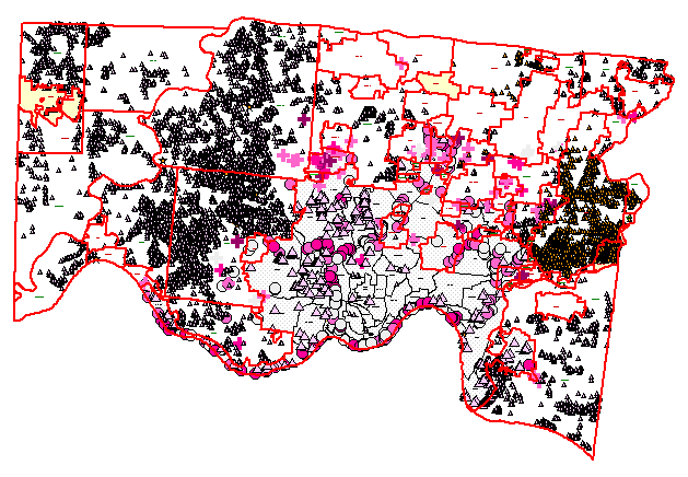
Figure 1: Hamilton County Pollution Concerns. These include
failing private household sewage systems (triangles), combined
and sanitary sewer overflows. Other concern maps included the
themes listed above.

Figure 2 Water Quality Monitoring - Fecal Coliforms. Water
quality data from MSD's on-going stream quality survey data showed
the influence of urbanization and land use. The Cincinnati urban
area is shown in pink. Pie chart position denote location of sampling
site and the pie slices are percent of fecal coliform samples
within a given concentration range. Other similar analytical data
includes metals and organics. This coverage showed significant
contamination occurring within and upstream of some urban areas
from non-point sources.

Figure 3 Failed Private Sewage Systems. This map incorported
the county health department inspection database using its failure
code attributes. Areas of multiple failed systems were observed
and influenced a "high" rating of related water quality
issues.

Figure 4 Suburban vs. Urban View of Contrasting Sources of
Contamination. This map showed different but significant water
quality stressors in suburban (western half) and urban (eastern
half): the suburban private sewage systems and the combined sewer
overflows and sanitary sewer overflows found in the urban area.
Income level from census data is also overlaid and helped to understand
environmental justice issues (darker green denotes higher income
levels).
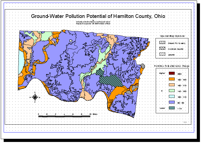
Figure 5: Ground Water Pollution Potential. Output of a model using soil and hydrology layers indicated where the most vulnerable aquifers existed.
As action plans were researched and developed, a series of meetings
were conducted in communities within the county to present the
project findings and to obtain feedback. Map coverages assisted
community residents in understanding and monitoring the impacts
and action plans potentially affecting their neighborhood. The
benefits were numerous and included better communication, a new
understanding of many environmental issues and a growing library
of databases and information, and useful anecdotes to share. Enthusiasm
emanated from participants and the public when recognizing familiar
graphic features of their own neighborhoods or communities coupled
with new information in the context with various environmental
themes and background graphic attributes. An improved awareness
of these impacts resulted from spatial presentation and, in turn,
lead to a more rapid (exceeding most individual predictions) consensus
in defining and rating the issues.
The most important outcome of this issue defining and rating process
was an increased respect, understanding and appreciation of diverging
viewpoints. The process proved to be as important as the product
(consensus) itself. Once again, GIS provided the single best means
of depicting the multitude and relationship of impacts and the
most effective means of communicating them between and among the
working groups and the public.
The GIS, provided an invaluable information repository, and an
analytical and viewing tool by placing large amounts of attribute
data in a common framework of location, (i.e. by neighborhood,
community, watershed) and in context with other familiar features
and impacts. The GIS also served as the only expedient way to
present, analyze and clarify environmental equality issues, especially
delineating potentially vulnerable areas due to their location,
population density, income status and/or potential cumulative
effects. When the HCEPP final report is completed this year, the
GIS data sets become part of the Cincinnati Geographic Information
System (CAGIS) framework. Also, a planned expansion of the HCEPP
Internet site will provide a ready means to track the progress
of implementing each phase 2 action plan. The site will utilize
ArcView IMS and MapObjects to include the support of user-defined
spatial queries. A neophyte HCEPP map site is found at http://www.queencity.com/hcepp.
Special thanks go to Bob Babbs and Evring Francis for MSD, HCEPP
Staff and Water Working Group members especially Xinhao Huang,
Bruce Koehler, Terry Hull, Dan Peterson, Tina Hayes, John and
Helen Hunter, Jim Kriesel, Pat Timm, Jan Ruebens, Amy Shollenberger,
Bob Temple and Brandon Brown to name a few.
Hamilton County Environmental Priorities Project
2828 Vernon Place
Cincinnati, OH 45219
phone: 513-221-8853
fax: 513-221-4820
email: environmental_priorities@pol.com
web: http://www.queencity.com/hcepp
Michael Sweeney, Ph.D., P.E.
Deputy Director
Metropolitan Sewer District
1600 Gest Street
Cincinnati, OH 45204
phone: 513-244-5120
fax: 513-244-1399
email: michael.sweeney@cinmsd.rcc.org
Thomas Quinn, P.E.
Director
Metropolitan Sewer District
(same address)
phone: 513-244-5121
fax: 513-244-1399
email: tom.quinn@cinmsd.rcc.org
Barbara Quinn
CAGIS Administrator
138 East Court Street
Cincinnati, OH 45202
phone: 513-352-1641
fax: 513-352-3557
email: barb.quinn@cagis.rcc.org
Richard Allen
MAGIC
810 Matson Place
Cincinnati, OH 45204
Phone: 513-921-2568
email: rich.allen@cagis.rcc.org
Human Health Issues
Quality of Life Issues
Ecosystem Issues
Economic Issues
Equality of Impact Issues