| Discussion It became apparent to
the students in our studio that everyone involved in the development review process
(including the public, the developers, and the government employees/elected officials)
could benefit from increased access to the GIS data being used now by a only a few of the
participants. The advent of widespread use of web browsers on home and office PC's is
actually the key element which provides the great potential for applications like our
prototype to be realized.
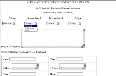
The prototype GIS-enabled web site application implemented
by the students demonstrates that by using ArcView IMS, it is possible to provide the
benefits of GIS data access to the public efficiently, affordably, and effectively. The
prototype also demonstrated to us that the development of these types of applications
could be accomplished rather quickly because it was relatively easy to learn how to use
ArcView IMS if one already knows how to use ArcView GIS.
Not surprisingly, the students found that, in general, many
steps of the development review process would benefit from the availability of a more
comprehensive GIS database. The studio participants believe that by making existing GIS
data more accessible, it may be easier to build support for the development of a more
comprehensive GIS database because the potentially many new users will better understand
the potential benefits of a GIS. By focusing on the comprehensive GIS data needs of the
development review process, the need for, and benefits of coordination between agencies
and departments also became more obvious.
Finally, we learned a few simple, and practical lessons for
implementing an IMS application. First, analyze your target audience carefully, and then
design your ArcView 'project' so that each view addresses only one, or at most two, of the
needs or objectives of your potential users. It is easy to get 'carried away' with too
many themes and too much information in any one 'view', in which case you will be more
likely to confuse many of your potential users. Second, use the 'Comments Field' in your
view properties dialog. Your comment will appear in the Map Cafe dialog box. It is easy to
do and can provide the user with special instructions for using the view. Finally, if your
tabular data fields have 'cryptic' names and/or values, make an alias for the items that
is more descriptive, and/or use self-descriptive attribute values. Also use the 'hide
field' feature to prevent fields such as the 'shape' field item(which is meaningless to
most users) from showing up when the 'identify' button is used. We found that implementing
these very simple steps helped make our more effective and less confusing to users.
If you have any further questions or comments regarding
this prototype, please feel free to contact Brad Scott at brads@geoplan.ufl.edu
Acknowledgements
Studio Members: Valentine Boycheva, Don Browning,
Eric Finnen, Jessica Green, Mark Nelson, Brian Pessaro, Mario Ripol, Brad Scott, Brent
Wilson
Studio Instructors: John Alexander, J. David
Lambert
We would like to thank the following people for their
contributions to this project:
City of Gainesville: Stewart Pearson, Public Works
Department; Maki Brown, Graphics Coordinator; Allison Fetner, Gainesville Public Works;
Officer Sterling Keys, Gainesville Police Department; Meg Neiderhoffer, Arborist,
Department of Parks and Recreation; Chad Reese, Gainesville Regional Utilities; Daniel
Starbuck, Fire Protection Technologist; Building Inspection Department; Marcie Stenmark,
Bicycle and Pedestrian Coordinator; Brenda Strickland, Permit and Development Coordinator;
Kathy Winburn,Community Development Department;
Gainesville Regional Utilities: Ellen Underwood, Services Coordination; Rich
Watkins, GIS Manager
Alachua County: Ann Ayers, Planning Department; Bob Bates, Property
Appraiser’s Office; Russ Bedell, School Board Student Services Information Database;
Brenda Cochrane, Planning Department; Michael Drummond, Environmental Protection
Department; Penny Hauck, Environmental Protection Department;
Development Community: Ralph Eng, Eng, Denman, and Associates
John F. Alexander, Ph.D.
Professor and Director
GeoPlan Center
431 ARCH
Department of Urban and Regional Planning
University of Florida
Gainesville, Florida 32611
voice: 352-392-0997
fax: 352-392-3308
email: johngeo@ufl.edu
J. David Lambert, M.S.
Research Associate and Project Manager
GeoPlan Center
431 ARCH
Department of Urban and Regional Planning
University of Florida
Gainesville, Florida 32611
voice: 352-392-2056
fax: 352-392-3308
email: dlambert@ufl.edu
Bradley J. Scott
Research Assistant
GeoPlan Center
431 ARCH
Department of Urban and Regional Planning
University of Florida
Gainesville, Florida 32611
voice: 352-392-0997 ext 228
fax: 352-392-3308
email: brads@geoplan.ufl.edu
|