The Egyptian
Central Agency For Public Mobilization And Statistics (CAPMAS) and GIS
Center (GISC)
ENG. MOUSTAFA
M. AHMED
ENG. TAREK M. A. HASSAN
CHIEF
MANAGER OF GISC
PROJECTS MANAGER - GISC
1. INTRODUCTION
The Egyptian Central Agency For public Mobilization
And Statistics (CAMPAS) is considered, the official source for providing
all the country organizations, universities, research centers, individuals
and international organizations, with data, statistics and information
that help in planning, development, evaluation, policy formulation and
decision making purposes. The agency with its huge human capabilities,
technical expertise and advanced equipment is considered one of the most
important agencies in the country at a time data and information represent
the most important factor to achieve success and development in every area
and activity.
The agency is carrying out several and various responsibilities
in every fields of statistics, public mobilization, and information systems
and the related activities, through conducting field surveys, technical
studies, systems analysis, designing, collecting data from its resources,
and conducting data processing and tabulation for these data. The agency
is considered as an experience house at the national level in the field
of statistical data, spatial data and information, and is always keen to
provide accurate data in suitable time and form.
One of the important internal centers in the Agency
is the Geographic Information System Center (GISC) which is established
to provide all the tasks, the applications and the consultant related to
the spatial data, also to provide very high quality services in GIS field.
2. GEOGRAPHIC INFORMATION SYSTEM CENTER (GISC)
MISSION
This center consists of large computer network depend
on TCP/IP LAN, X25, and Internet services, which links the different branches
in governorates with CAPMAS and covers the various activities that help
in all planning and following up operations.
This network allows the exchange of data among these
governorates to support decision making and policy formulation. Eight governorates
have been already included in this network, (Great Cairo, Alexandria, Port
Said, Ismaillia, Suez, Gharbia, Dagahlia and Fayoum) and the remaining
governorates will be gradually included in the network.
We can brief the main mission of the center in the following:
-
The provision of base maps that are needed in undertaking the national
Censuses.
-
Linking the statistical data to its geographic features for better presentation
in the lower administration level and performing all the needed analysis.
-
Building Digital Base Map (DBM) in all the knowing format and make
it available for governmental and private sectors which work in the GIS
field.
-
Building regional geographical statistical Database for each governorates
to help in local decision making.
-
Providing any consultant help for any governmental and private sectors
to build their own GIS centers or to build their own GIS applications.
.
3. CURRENT GISC PRODUCTS
-
Producing the Analogue and Digital Base map of the urban areas for seven
governorates (Great Cairo, Alexandria, Port Said, Ismaillia, Suez, Gharbia
and Dagahlia), to use in the cartographic purposes, scale 1:5000. Produced
in 96, updated in 98, available in different formats.
-
Producing the Digital Base map of the urban areas for the governorates
to use in the GIS purposes, base map contains about 70 layers describes
all the available landuses and activities (schools, hospitals, factories,
etc.), available in ArcInfo, MAPINFO and GENAMAP formats.
-
GISC produces general and detailed maps with different scales suitable
for statistical work and censuses.
-
GISC builds Turn Key solutions for government and private organizations
and agencies in the field of GIS and Information system.
4. SOME APPLICATIONS OF GIS WITH GISC
4-1 GIS AND CENSUS 96
In this application we connected all the required census
96 data to the three administration levels (Governorate, Section and Subsection)
maps produced in different scales (1:500,000 and 1:5000), for displaying,
retrieving, inquiring and analyzing the census data in spatial methodology.
Geographic Coverage:
Egypt with 1:500,000 maps and 1:5000 for second and third administration
levels maps
Application Capabilities:
-
Displaying various information layers of the Arab Republic of EGYPT such
as (main high ways, wells, oil fields, airports, etc.)
-
Displaying all the available population census data on the different administration
levels.
-
Joining some layers with Multimedia movies set as another dimension of
the spatial data.
-
Making all the needed spatial and network analysis.
-
Printing and plotting all the needed maps and reports.
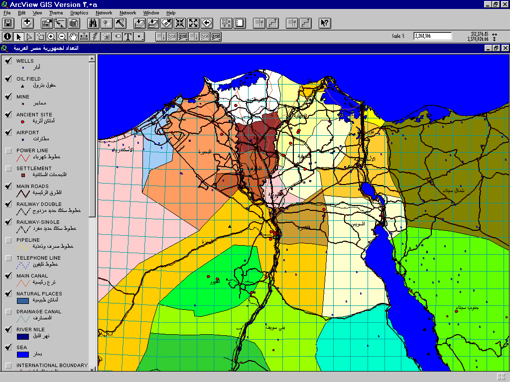 figure (1) Egypt governorates
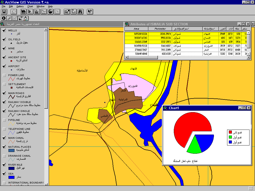
figure (2) sections and subsections of Ismaillia city
4-2 ARAB REPUBLIC OF EGYPT SPATIAL URBAN DATA BASE
The purpose of this application is to build a nation
spatial urban database in the level of all urban areas in the governorates
of the Republic, we finished seven governorates (Great Cairo, Alexandria,
Port Said, Ismaillia, Suez, Gharbia and Dagahlia) till now and working
in the Arial photographic processing and the conversion for the rest.
The system contains about 70 different Information layers such as (schools,
hospitals, streets with different categories, etc.), this layers consider
the main base for any GIS application such as Streets layers which consider
as separate application used in all network applications (Marketing, Emergency,
etc.)
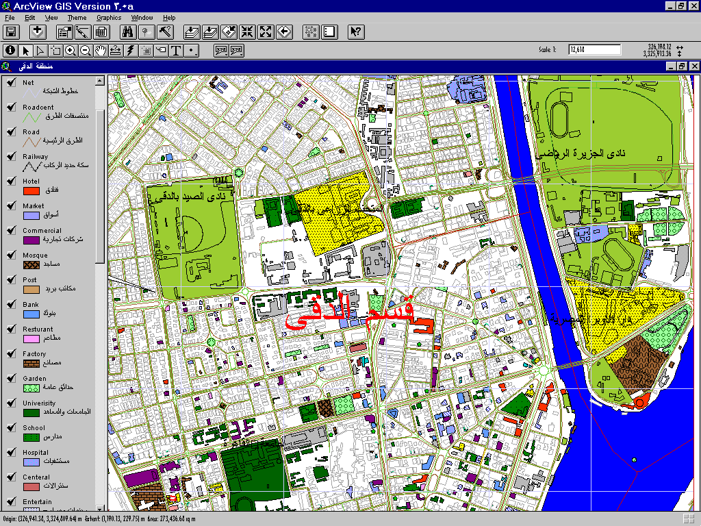
figure (3) land use of Dokki section
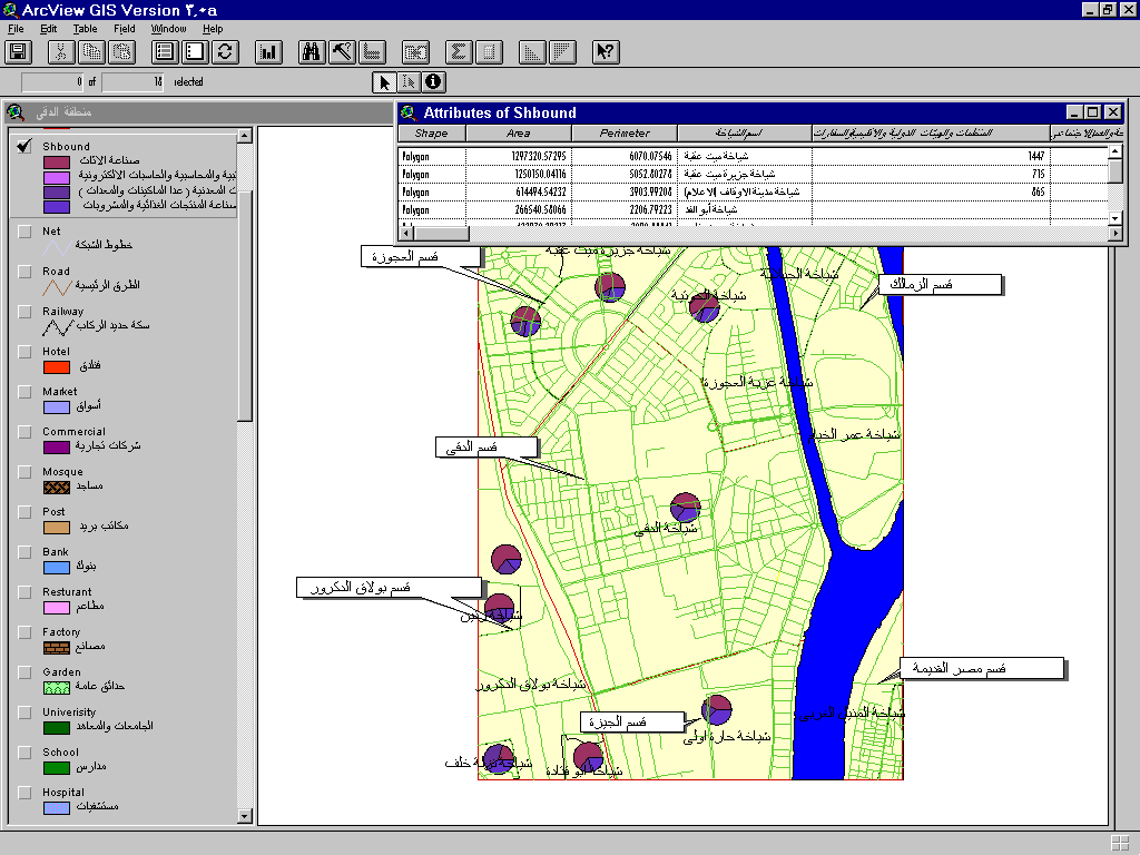
figure (4) the activities distributed in subsections for
part of Giza governorate
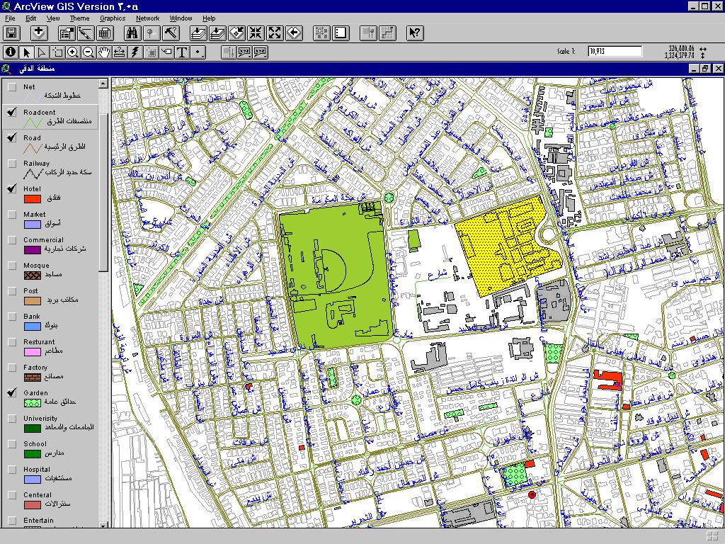
figure (5) the complete set of streets in specific area
in Dokki section
4-3 SALE-TAX GIS APPLICATION
In this application we connected the recent database
of the SALE - TAX Organization (GSTAX - INFORMIX based) which contains
the registration information and daily operations of the customers to their
geographical locations of each customer, also the application is depended
on the basic layers of base map (Hotels, Commercial units, Factories, etc.).
Geographic Coverage:
Great Cairo with 1:5000 maps
Application Capabilities:
-
Displaying all customer locations and the detailed data (name, registration
number, address, registration office, daily operation, etc.).
-
Inquiring and finding any entities (customer, registration office, new
address, etc.) by their attributes.
-
Making all the needed spatial and network analysis such as finding the
best route of movement from the registration office to a group of customers.
-
Joining some layers with Multimedia movies set as another dimension of
the spatial data.
-
Printing and plotting all the needed maps and reports.
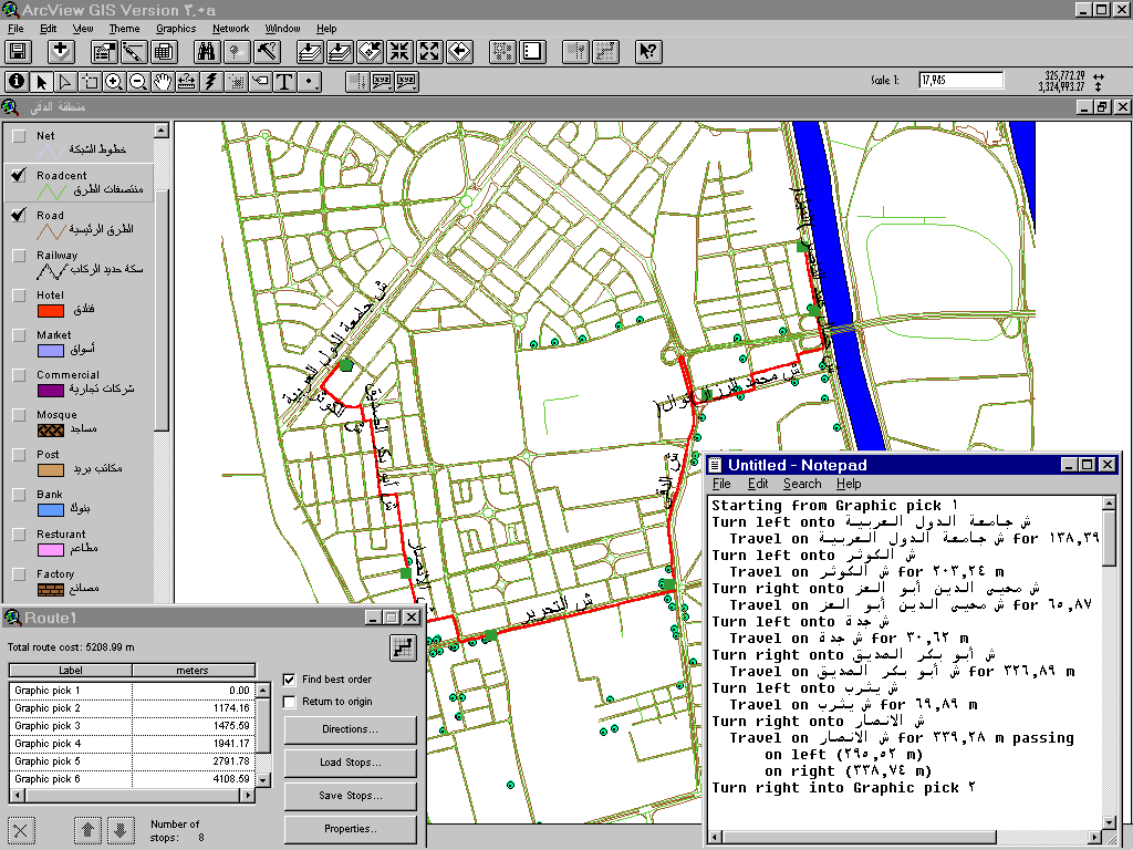 figure (6) Network Analysis (SALE - TAX Application)
5. CONCLUSION
The most important conclusion we can draw from the above discussion is
that GIS is a very important tool in Government work. Almost anybody can
be an end user and can benefit from the system.
Also, it is evident that statistics and national census data are considered
as the basic component in planning, development, policy formulation and
decision making. So using GIS with statistical and census databases reduce
the data blindness due to the multidimensional.
Finally, coordination with all GIS working organizations must be considered
to insure integrating information from different organization for planners
and decision-makers, management and technical cooperation is required to
ensure that common GIS standard and procedures are developed and followed.
ENG. MOUSTAFA M. AHMED ENG. TAREK M. AHMED HASSAN
capmas1@idsc1.gov.eg
thassan@hotmail.com
CENTERAL AGENCY FOR PUBLIC MOBILIZATION AND STATISTICS (CAPMAS).
P.O. BOX 2086
SALAH SALEM ST., NASR CITY, EGYPT