Abstract
Daily, KNMI processes a huge amount
of heterogeneous spatial data involving models, observations,
radar and - increasingly - satellite imagery. In order to link
up with internal and external user needs, existing tools appear
to be too dedicated and, hence, fail to allow for flexible data
integration, exchange and visualisation. When KNMI started its
METEOGIS project in 1997, experience with GIS at meteorological
offices was limited. Since then, a number of studies has been
initiated to demonstrate the value of GIS technology for the KNMI.
Besides the introduction and implementation of GIS software in
the existing technological infrastructure, the METEOGIS project
has focused on e.g. the conversion of data stored in formats prescribed by
the World Meteorological Organization (WMO) and integration
(a fog sensitivity analysis).
Background
Founded in 1854, the Royal Netherlands Meteorological Institute (KNMI) is the national expert centre for weather, climate and seismology. Besides providing daily weather forecasts to the public and professional users (e.g. aviation and shipping), KNMI unfolds initiatives for (international) research in the above-mentioned areas of interest. The huge amount of data that has to be processed each day to meet the operational and scientific requirements is impressive, and acts as an incentive for the continuous improvement of the data infrastructure. The Observations & Modelling department is the "data pillar" of the institute and is, as such, responsible for the acquisition, processing, validation,storage and distribution of meteorological data. These data can be ordered in the following categories:
A dedicated data and computer system
infrastructure safeguards the operational tasks, i.e. the continuous
monitoring of the weather pattern. Most of the data used in these
processes are stored in binary formats such as BUFR (Binary Universal
Form for the Representation of Meteorological Data) and GRIB (Gridded
Binary), in accordance with the guidelines issued by the World Meteorological
Organisation (WMO) .
The heterogeneousness of the described data sources and the desire to combine, analyse, visualise and otherwise manipulate the diverse data - beyond operational applications - has aroused the interest in GIS. Meteorological data are in essence spatio-temporal but this fact notwithstanding, the majority of meteorological institutes hasn't adopted GIS as a main part of their data processing infrastructure. The reasons why KNMI decided to invest in these tools are multiple and can be summarized as follows: to
The ideas have taken shape with the
start of the Meteogis project in April 1997. Over a period of
2 years, efforts are directed to the embedding of GIS technology
in the existing IT-infrastructure. Being halfway through the project,
this paper will report on the first results of a case study. In
addition, it will clearify the considerations that have played
a decisive role during the introduction of GIS "from scratch".
The Meteogis project
In view of the presence of large amounts
of spatio-temporal data, the absence of commercial GIS packages
at meteorological institutes is striking. From an exploratory study,
preceding the introduction of GIS at KNMI, it appeared that only
a small group of national services in Europe had acquainted themselves
with this particular software (e.g.
Météo France ,
DNMI from Norway).
Two important short comments can be
given on this fact. In the first place, climatological research
institutes are known to be more familiar with GIS than operational
services - the exploration of the "historical" databases
lends itself particularly well for a geographic approach. Secondly,
there exist numerous "GIS-like" applications, especially
developed for meteorological purposes and establishing seamless
links with current operational tools by the ability to process
WMO data formats directly. The ECMWF for example (European Centre
for Medium-Range Weather Forecasts) distributes its Metview
software freely among its member institutes, including KNMI. The advantages
of such dedicated software notwithstanding, there remains a need
for indeed less customized but therefore more flexible and open
GIS tools, as pointed out in the previous section. (Another example of
dedicated meteorological software is Zebra).
In the framework of the Meteogis project, a user requirement analysis has been conducted. Five different classes of requirements were taken into account, to wit:
After an extended weighing of all the
contributed criteria and an even more elaborated study of commercial
GIS packages, KNMI decided to buy Esri and Erdas products. As a start, both for Unix and Windows95, 2 licenses Arcview,
including 1 Spatial Analyst, were purchased - together with one license ArcInfo (with GRID and TIN). After an implementation
and training stage, involving a limited but enthusiastic group
of "pioneers", the Meteogis project started with its
first case study to inform interested persons on the possibilities
of GIS. Because the results of such a "pilot" are far-reaching
as far as the receptivity of potential users is concerned, a topical
and meteorologically interesting subject has been selected: the
fog sensitivity of highway sections, directly relating to severe
traffic accidents.
Case study: a fog sensitivity analysis for
western North-Brabant
Objectives
The case study focuses on the derivation
of a fog sensitivity map, thereby illustrating the potential of
GIS when dealing with meteorological and climatological issues.
The usefulness of these tools may be beyond dispute in geo-disciplines,
in meteorology it is only starting to find its niche. As an example,
consider the fact that a search on the Esri Internet site resulted
in only slightly more then 10 hits! Eventually, the fog project
could arouse the interest of different authorities in order to start a study
to identify possible risky road sections on a more structural basis.
The application of such information in the development of well-balanced
fog detection and traffic control systems is easily imaginable,
given the fact that dangerous and suddenly looming patches of fog are held
responsible for tragic accidents involving many road casualties .
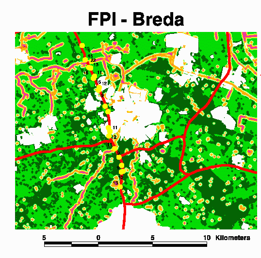
Study area
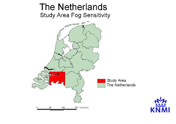
The area on which the case study is
focused is part of the province of North-Brabant (figure 1). A
closer look is taken at the surroundings of Breda, because of
a serious and tragic accident in 1990, as a direct consequence
of treacherous fog reducing visibility values dramatically. Since
then, visibility sensors have been installed along that particular
road section thus providing valuable reference data for the case
study.
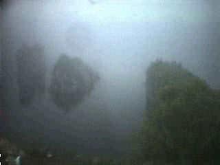
Fog
Fog often manifests itself as a "cloud
near the earth's surface", thereby seriously hampering visibility
values (less than 1000 meter) by the presence of small drops of
water in the atmosphere (figure 2). Meteorologists make a distinction between
several types of fog: advection fog, frontal fog, hill fog and
radiation fog, for example (Musk, 1988). In this particular paper,
the latter is considered because it is held responsible for the
suddenly looming and dense fog banks in which motorists are caught
(mostly between October and March) causing severe traffic accidents.
Radiation fog is caused by an interaction of different processes:
The above description of the development
of radiation fog is simplified. In fact, the process of emitting
long-wave radiation from ground to atmosphere (loss of heat) is
complicated and affected by several factors. Especially the very
first steps in the development of radiation fog are hardly understood
(Wessels, 1993). In general, the most favourable meteorological
conditions for the occurrence of radiation fog can be summarized
as follows, according to Musk (1988): clear night sky (loss of
radiation), moist air at sunset (automns and winter, after rain
or near open water) and a weak wind (vertical mixing of misty
layer to spread cooling upwards).
Nowadays it has become clear that not
only meteorological factors play a role in the development of
radiation fog. The availability of sufficient moist near the surface
is dependent on the climatological history of an area (e.g. the
amount of rainfall during the last 24 hours), but the characteristics
of the soil (e.g. sandy or clay-soil) and the ability of vegetation
to hold moisture are decisive as well. The cooling of the earth's
surface is determined by the coverage of the soil and the soil
type itself, although Wessels (1993) correctly states that this
factor is less leading because the emission is stronger above
sandy (and thus relatively dry!) grounds.
The assessment of fog sensitivity for the study area has adopted two different methodologies, to wit the soil moisture approach and the Fog Potential Index (Dixon, 1989; Musk, 1988). Both methods consider non-meteorological factors, such as soil type and topography, and are in general well-documented. For the considered case study, concepts have been translated in GIS fuctionality such that an arbitrary road section can be subjected to either of two approaches. It is emphasized that relating actual meteorological parameters with physiographic characteristics in a GIS environment is beyond the scope of this paper, although it is perceived as a logical follow-up in the research project.
Methods
The derivation of a fog sensitivity map is achieved according to the following two approaches:
The former results in absolute estimates
of fog sensitivity, expressed as the possibility that visibility
values decrease to less than 200 meter. The latter method compares
the differences between road sections by assigning an index number
between 0 and 100, with higher values corresponding to potentially
more (fog-)sensitive locations. Terpstra et al. (1997) note that
high values do not necessarily mean risky road locations as this
may depend also on road conditions (windings, congestion...).
GIS tools
For the fog sensitivity analysis, both
Arcview and ArcInfo are used. The latter has been applied mainly
for preprocessing tasks (e.g. joining and editing map sheets)
whereas Arcview has been selected as the environment in which
the actual demonstration has been developed. Obviously, the learning
curve of Arcview is far more steeper than ArcInfo's (remember
that KNMI started from scratch!) - an advantage for the newly
entered GIS operators who had to work under stiff time limitations!
The Spatial Analyst has proved to be of the utmost importance
for KNMI-applications, especially when extending its functionality
with Avenue scripts.
Approach 1: soil moisture
Originally, soil type is taken as a
measure for the amount of moisture that is present near the surface.
As stated previously, soil type is important as it is related
to the humidity of the surface and the capacity of that surface
to radiate heat - and thus contributes to the prerequisites for
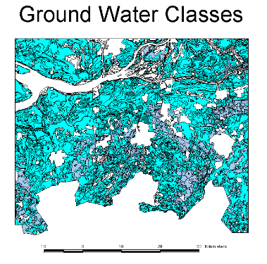
the development of radiation fog. In this study, however, soil
type is only indirectly applied - here more objective ground water
levels (as indicated on the soil map of the Netherlands 1:50000)
are choosen as a starting point (see figure 3). Table 1 shows the classification
of ground water levels that has been adopted during the study.
Four soil moisture classes have been discerned, after discussions
with meteorologists of KNMI.
In theory, the class values can be inserted in a formula with which permillage fog is derived, that is, the permillage of time that is characterized by a visibility of less than 200 meters (dense fog) :
The above formula is the result of a regression (Wessels,
1993), based on visibility measurements recorded by fog detectors
along the A-16, a highway intersecting the study area. The fog
sensitivity map resulting from the soil moisture method is not
converted to these quantitative classes, however, because it is
felt that more statistical material (prolonged visibility measurements
along highway sections) are needed for a reliable estimation.
Moreover, the soil mositure classes which are applied in the regression
are based on soil types, not on ground water levels as is the
case in the present case study! The soil moisture map as derived from the ground water
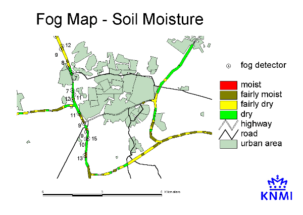
level map is shown in figure 4.
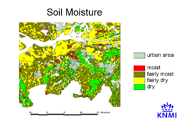
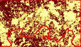
The resulting map is shown in figure
5. Some topography is added for reasons of orientation. The
highways are shown in a colour that corresponds with a moisture class
that is representative for the direct surroundings of these roads.
Moist spots are noticed there where the highways cross meadow-land
whereas dry sections are identified near the dry sandy grounds.
The general impression of the map complies with the existing ideas
based on extended field-work. As a reference (but given the limitations mentioned earlier)
a number of mean annual fog detector observations are provided (as a promille). It becomes
clear that in the open area northward and southward of the city of Breda, higher values are
more likely to occur. But again, it is hardly possibly to draw any conclusions from these data!
At the same time it is admitted that there are probably more criteria to reckon with in order
to obtain a more reliable image. Consider for example the proximity
of factories emitting large quantities of water vapour or the
presence of a pine forest that more or less dissolves the patches
of fog!
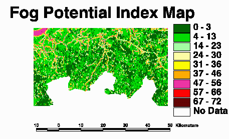
Approach 2: Fog Potential Index
Musk (1988) describes a method to index the susceptibility of a particular area to thick radiation fog. He expresses this Fog Potential Index as a function of four predictors:
with
dw = a measure for the vicinity of water (brooks, rivers, lakes) and the extensiveness of
these water surfaces;
tp = a derivative of local topography - height, slopes, curvature of the terrain;
sp = a function of the position of the road itself (height, e.g. an embankment);
ep = a factor describing environmental characteristics that either help or hinder the
development of radiation fog (e.g. the proximity of urban areas and industry).
Musk (1988) has applied his method for
study areas in Great-Britain and the exact weighing of the above-mentioned
parameters is still not completely understood. Weights of 10,
10, 2 and 3 respectively are used in the original study, while
the value of the parameters themselves varies between 0 and 4. The
literature fails to provide rules for the assignment of these
5 classes to each of the predictors; without sufficient clues,
comparisons between different FPI-studies remain hazardous operations!
In consultation with experts of KNMI, the following grouping
has been assessed (table 2). Notice that we have initially distinguished
between small and large water surfaces - eventually, the value
for dw is determined by picking the maximum predictor
value for either dw small or dw large.
| |||||
From table 2, a number of observations
can be made. In the first place, a higher value for the predictor
means a higher potential contribution to the development of radiation
fog. From this, it becomes clear that the environmental characteristics
only consider the vicinity of urban areas and forests ("dissolving"
fog) and exclude the presence of steaming industrial complexes
(factories that are seriously producing water vapour are not identified
in the study area). Next, information about the position of the
road, relative to its surroundings, is lacking completely. The
results of the present study will hopefully lead to a situation
in which these valuable data (administered by the Dutch Directorate
General of Public Works and Water Management - Rijkswaterstaat)
come at the disposal of meteorological and climatological institutes.
Finally, a remark can be made with respect to tp. The
susceptibility for radiation fog is severe in those areas that
are concave and characterized by a certain minimum slope angle.
These values appear to be critical for cold air masses that descend
from higher spots and subsequently flow to lower situated road sections.
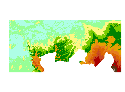
Figures 6 to 11 give an visual impression
of the predictors. As can be seen from figure 7, the influence
of the terrain is negligible - at least when using height data
at the considered resolution! Only the red spots would
contribute to the susceptibility for radiation fog, and they are at a
considerable distance of highways.The height map (figure 6) is obtained from
interpolating point data to a 50 meter grid (using ArcInfo, thereby
reducing CPU time considerably), but more detailed data would
possibly reveal interesting micro-rellief.
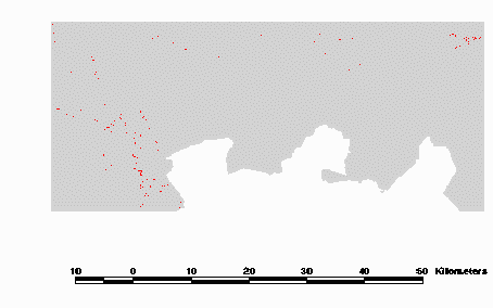
The vicinity of water, especially lakes,
rivers, brooks and ditches seems to be of more importance for
the fog susceptibility of the study area. It is interesting to note that
small but characteristic ponds, e.g. as digged in the neighbourhoud of cloverleafs, are emerging
in a very pronounced way from the map (figure 8, small and dark spots).
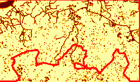
The environmental predictor (figure 9) can be interpreted according to the same legend as the previous one. Clearly,
the proximity of urban area has a counteracting ("positive") effect on the sensitivity of the area with respect to radiation fog. Here, values are low
and thus hardly contribute to a high index number.
The resulting FPI-map, summarizing all three predictors (remember that the road topography
could not be evaluated, unfortunately) and weighing all contributions according to the earlier mentioned weights, shows a pattern
that reveals a high correlation with the "water map"
(figure 10).
References
Dixon, J.C. (1989): Current techniques
for assessing (indirectly) the localized incidence of fog on roads.
Meteorological Magazine, 118. pp. 99-104.
Musk, L.F. (1988): The assessment of local fog climatology for new motorway and major road schemes. Proceedings of the International Conference on Meteorology and road Safety. Florence, November 1988. pp. 779-797.
Terpstra, J.M., D. Blaauboer & P.A.T.
van Es (1997): Mistonderzoek A-58 ten zuiden van Breda (in Dutch).
Wessels, H.R.A. (1993): Meteorologische
evaluatie van de zichtmetingen langs de A-16. KNMI Technische
Rapporten: TR-157 (in Dutch).
About the Author...
Frans J.M. van der Wel
Royal Netherlands Meteorological
Institute
Observations & Modelling
Department - Satellite Data Division
P.O. Box 201
3730 AE De Bilt
The Netherlands
Telephone: +31 30 2206822
Fax: +31 30 2210407
welvdf@knmi.nl