 Tripod Data Systems "Solo" unit
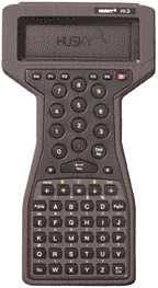
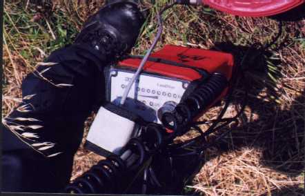
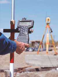
These components make up the GPS unit used in this project. The Husky unit is the main input device and the Racal unit communicates with the DOD satellites and receives the differential correction signal
This paper describes how firemen in Euless, Texas, are using GPS to collect hydrant locations and in-the-field data that is then imported into Arc/Info to be processed. Afterwards, it is fed into the Fire Dept.'s pre-plan software to help with fire suppression scenarios. The data is also used by Public Works to identify hydrants that may be out of service due to line repairs and relay that info to the dispatchers so that the pre-plan scenarios can be automatically updated by the FD's software.
In an effort to facilitate incident reporting and computerize their response pre-planing, the Fire Department aquired a new management software called 'Firehouse'. This software has an open-ended database that allows external data to be imported. The first use of this feature was to import all of the addresses for all of the city's homes and businesses so that a pick list would be available on the incident report screen. This data came from the GIS, where it has been tested and used for the past 10 years.
Then a request came in for fire hydrant data. More specifically they wanted to assign a unique identifier and capture the lat/long of the hydrant locations. The first response from the GIS staff was that before we went to the trouble of importing this data, we would need to do a hydrant inventory to be sure that all of the hydrants were accounted for. Sounded like a lot of work, so we figured we'd add to it. Why not collect condition and manufacture date while your there? What else can we collect? More thought needed to be put into what we didn't know about the hydrants before anything was imported into the 'Firehouse' software.
Tripod Data Systems "Solo" unit
These components make up the GPS unit used in this project. The Husky unit is the main input device and the Racal unit communicates with the DOD satellites and receives the differential correction signal
Coincidentally, the GIS department had aquired a GPS receiver for use in a utility collection project. The plan was to collect the location for visible features of the water, wastewater and storm drain systems. The GPS system is made by Tripod Data Systems and allows for the creation of a custom collection interface. It uses the Racal satellite receiver for on-the-fly data correction to give real time differential GPS accurate to 1 meter. It's also a lightweight system that's fully inclusive on the stick (no back packs or belly bags). Finally the light went on. Fire hydrants are a visible feature of the water system! We could utilize the manpower of the Fire Department to help accomplish one of our own projects. (Hmmm, sounds like less work for me) The GIS staff quickly met with the firemen and proposed them using the GPS receiver to collect the lat/long of the hydrant as well as filling out a form of other hydrant features they wished to collect.
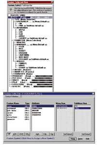
The menu for attributes to be collected in the field is created in the Solo software.
There was a whole host of fields they wanted to populate in their 'Firehouse' database, but it was way too much for the firemen to type in while standing in the hot sun. That's where the cooperative effort with the GIS staff paid off. If the firemen were willing to collect some data in the field, the GIS staff were willing to populate the remainder from the existing water system map. Field data to be collected included year of manufacture (cast into the side of the hydrant's base), the make, the general condition, the street the hydrant faced, a memo field of what maintenance was performed, and if the blue reflector was correctly placed in the street. Oh yeah, and the GPS location of the hydrant. Only six items, but that was about the limit of what one could observe about a hydrant while standing in front of it. They would also stamp a metal tag with the hydrant's unique identifier and rivet this to the barrel of the hydrant.
Training the firemen to use the GPS proved to be extremely simple. The original plan was to team them with the GIS staff for the first day and then be on call for followup training after that. After collecting data at three or four hydrants, the firemen were comfortable with using the system and had no further questions or the need for any further training. (I still got to spend a 1/2 day playing on the fire truck, though!)
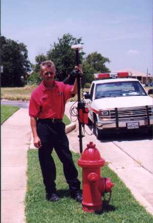
The firemen were given a map of known hydrant locations with their assigned ID numbers. Then they located them in the field.
More data existed already in the GIS's database, and when the field data was combined with the GPS location point and the water system maps, the remainder of the desired info was pieced together. This included adding a unique ID, a street address, size of the feeder main, fire response zone, hydrant model, fire district, nearest station, and the lat/long translated from state plane. In all, eighteen fields were populated and transfered into the 'Firehouse' software.
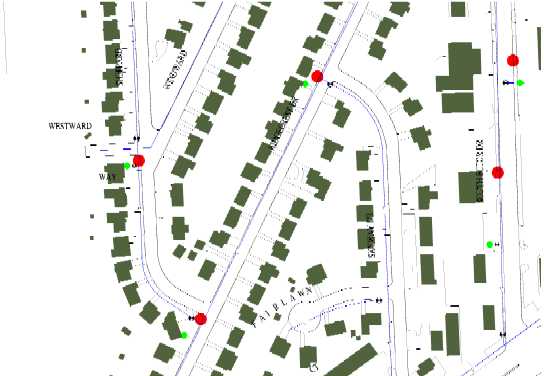
The map on the left shows the raw data shown in ArcView. After a shapefile conversion, the data is updated in Arc/Info to contain data relating to the water system. Green dots are where we thought the hydrants were - red is true location
In addition to the useful data we were able to pipe into the Fire Dept.'s software, the GPS location of the hydrant was handy in helping to increase the accuracy of the water map. New hydrants were added, bogus hydrants were removed, and most others were shifted slightly to correctly represent their true location. Later, when the same procedure is done on valves, the accuracy of the water maps will be increased even more.
Besides that obvious benefit, there were some other benefits that helped other departments. Public Works, for example, often has to describe to Police/Fire dispatch the location of hydrants that are being taken out of service for water line repairs. Their descriptions were often "the one in front of the third house on the left north of the intersection", and usually left dispatch confused about exactly which hydrant was out. Now they reference the hydrant by it's unique identifier placed on the barrel and very quickly are clear which one is down. We can also identify lat/long locations in the city quickly based on the nearest hydrant. Firemen are thinking that they can provide this lat/long to the Care Flight helicopter ambulance so that it can find their location faster. This theory hasn't been tried yet, but it did sound plausable.
As an experiment, Public Works is using ArcExplorer to look up hydrants by their street address or by pointing in order to identify their number. This helps them identify hydrants that require additional maintenance that the FD would not normally do. The look-up feature works pretty well, but every time you re-start ArcExplorer, you have to re-populate the address geocoding fields. This is causing some problems, but they are learning to live with it.
About 1/2 the city had been done at the time this article was written so not all of the ramifications of the project have been fully realized, but the payoff is already there and the future can only bring more benefits. The next step for GIS will be to coordinate with Public Works to collect location points for the remainder of the visible features of the water system, then on to sewer and storm drains. The firemen will wrap up their project soon and are searching for additional uses that they may have for the GPS. Actually I think they just had too much fun playing with the cool new technology!