Sub-regional Detention Siting- A Methodology Using GIS
Abstract
The Mt. Scott watershed in northern Clackamas County, Oregon is an urban watershed that lies inside the Portland metropolitan urban growth boundary. Urbanization of the watershed began in the early 1970's and has recently accelerated. A landscape level analysis of the urbanization process was combined with the results of a recently completed storm water master plan for the area. The project resulted in the identification of potential locations for combined detention and water quality facilities. It also served to further justify the recent revision of surface water management rules and regulations to include requirements for lower release rates from detention facilities, riparian and wetland buffers, and restrictions on seasonal construction activities on steeper slopes.
GIS was used extensively throughout the project to provide data input into the XPSWMM model that was used to analyze storm water flows and to identify infrastructure needs and requirements. In addition, GIS played a pivotal role in analyzing the potential cumulative effects of the urbanization process on overall stream health in the basin. The results of this analysis project will be used in the continuing effort to develop a water quality monitoring program within the basin in the face of on-going development and continued urbanization.
Introduction
Integrated environmental management is a concept that is most often applied to the management of natural resources. The concept implies that management decisions need to be made in a larger ecological context versus employing a single-objective oriented and therefore, inherently fragmented approach. Most professionals do not believe that it is possible or even necessary to apply environmentally integrated management to a highly altered ecosystem such as an urban watershed (Cairns, 1995).
On the contrary, in urbanizing areas, increasingly land use decisions are made in order to accommodate a growing human population. Many of these decisions will result in the creation of large amounts of impervious surface and as a consequence a 40% to 60% increase in the amount of urban runoff (Urbonas and Benik, 1995). Runoff from urban areas has been found to contain high concentrations of heavy metals, pesticides, phosphorous, fecal coliform, oil and grease, and is a direct consequence of an ecosystem being paved (Cairns, 1995).
Individual development projects may have geographically-limited and often transitory adverse effects on adjacent streams and tributaries. However, the combined effect of multiple projects spread across the landscape over time may cumulatively affect the long-term integrity and functionality of the aquatic systems within the basin. Integrated management evaluates not only the environmental effects of a single land use action, but also the potential cumulative effects of multiple land use actions in the watershed. Because of the growing concern about non-point source pollution and resultant degradation of aquatic systems, integrated environmental management is increasingly becoming applicable in urban environments.
Urban runoff is only one of the many adverse consequences of urbanization, but its effects on aquatic habitat and aquatic life can be severe if appropriate and effective mitigation measures are not taken. The most effective techniques and strategies for surface water management address basin-wide issues rather than site-specific problems. Examining the urbanization process and its affect on aquatic systems from a landscape perspective provides a viewpoint from which the full impact of the development process may be accessed. Effective strategies can then be developed and water quantity/quality control facilities can be located in the watershed where they will be most effective.
Geographic Information Systems (GIS) can be thought of as being both the means of storing and retrieving data about the aspects of the earth's surface, and systems by which the data can be transformed and manipulated interactively for studying environmental processes and the impacts of planning decisions. GIS is ideally suited for studying the processes and impacts of diffuse pollution and have been used extensively in this research project (Connors-Sasowski and Gardner, 1991;DeRoo, Hazelhoff and Burrough, 1989; Evans and Miller, 1988; Potter, Giliand, and Long, 1986).
Scope and Major Objectives
This paper presents the results of a landscape level analysis of the urbanization process in the Mt. Scott watershed in Portland, Oregon. Results of the recently completed storm water master planning effort for the basin are also presented. In order to gain a better understanding of the possible connections between urbanization and declining aquatic health, several components of the urbanization process were analyzed at the landscape level. The results of this analysis were then overlaid with potential Capital Improvement Projects (CIP) identified during the surface water master planning effort for the basin. This was done in order to evaluate the overall benefit these projects might have on aquatic health of the watershed as a whole.
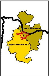
The effect of urban runoff on aquatic systems in this area is particularly important to study due to the March 1999 National Marine Fisheries Services' extension of federal protection to Chinook salmon and Steelhead in the Lower Willamette Evolutionarily Significant Unit or "LWESU". All watersheds draining to the Lower Willamette and Columbia Rivers (including Mt. Scott creek) are affected by this listing. No one knows exactly how the new listings will affect local residents but proposals are on the table to require all new developments to be designed in a manner, which prevents storm water runoff from discharging directly into streams and rivers (Figure 1).
The objectives of the study
were three-fold: to demonstrate how the on-going urbanization process is
occurring in the watershed; to identify the potential cumulative effects
of urbanization on the aquatic habitat within the watershed and analyze
the results of the hydrologic and hydraulic modeling that was performed
in the basin prior to the completion of the first two objectives. The XPSWMM
(Stormwater Management Model; U.S. EPA, 1971, Heaney and Huber, 1973) modeling
effort (July 1997) resulted in the identification of potential problem
areas within the existing storm water network; and identify potential locations
for both conveyance improvements and combined sub-regional detention and
water quality facilities. GIS was used to analyze the spatial aspects of
urbanization, identify significant changes that have occurred, and to provide
data input for the XPSWMM modeling effort.
Study Area
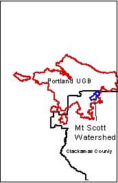
The Mt. Scott watershed is located in northern Clackamas County, within the Portland urban growth boundary and is typical of many of the urban watersheds found in the area (Figure 2). It is approximately 3380 acres in size and about 2/3 of the land base is currently urbanized. The watershed is hourglass shaped and bounded on both the north and the south by steep hilly terrain that drains primarily via well-defined channels, streams, ditches and culverts. Soil infiltration capacities are generally low causing most of storm generated runoff to be transported as surface water flow. The in-land valley areas, which form the headwaters and lower reaches of Mt. Scott creek, slow the rate of runoff causing ponding and flooding in several areas (Mt. Scott Surface Water Master Plan - MSSWMP, 1997).
In the early 1900's, land within the study area was primarily rural and consisted of forested land, cultivated fields, and pastures (MSSWMP, 1997). A 1976 aerial photograph of the watershed shows a landscape dominated by agricultural fields, forested land, and scattered pockets of well-established rural residential development in both the northeast and southeast sections of the watershed. Over the past 23 years, both high and medium density residential housing developments have been constructed in this watershed. Commercial and industrial development has been generally confined to the lower 1/3 of the watershed.
Riparian canopy densities ranged between 75 and 100 percent along most of the stream's length. A recent fish survey conducted by Oregon Department of Fish and Wildlife (ODFW, 1997) found a disproportionate number of tolerant fish species (reticulate sculpin, redside shiner and speckled dace) present in Mt. Scott creek and its tributary streams. Tolerance refers to a physiological resistance to high water temperature, sedimentation, and organic pollution (Hughes and Gammon 1987; Friesen and Ward 1996). According to the survey, Mt Scott creek does support small numbers of salmon and trout throughout the year and reproducing populations are probably present (ODFW, 1997).
Adequate gravel/cobble substrate for spawning and incubation is necessary for the survival of salmonid populations and does not appear to be a limiting factor within the creek. Channel erosion and siltation of the channel substrate may be a contributing to the mortality of developing steelhead eggs. Wydoski and Whitney (1979) report that suffocation due to siltation is a principle cause of steelhead egg mortality.
Based on site visits, channel incision and large deposits of construction-related sediment are most pronounced in the lower reaches of Mt. Scott creek and in one of the tributary streams (Mel Brook) these stream reaches generally flow through or are piped underneath large tracts of residential development. A recently completed survey of the stream indicates changes in channel stability are associated with changes in storm flow volume (MSSWMP, 1997).
Monthly water quality grab samples have been taken by Water Environment Services (WES is the agency responsible for surface water management in northern Clackamas county) since September of 1994. The elements sampled include temperature, TKN, E-coli, BOD, Phosphates, Ammonia, Nitrates, oil and grease and several heavy metals including: Zinc, Cadmium, Copper and Lead. To date, these data have not been analyzed in-depth; however, preliminary analysis indicates that a trend toward higher concentrations of several pollutants does exist. The findings of a recent Oregon Department of Fish and Wildlife survey of the creek reported an absence of aquatic habitat diversity, and a general lack of macroinvertebrate species in the creek.
Figure 1. Figure 2.
METHODS
Identification of contributing factors
Urban development
The urbanization process can be broken down into two distinct phases: the construction phase and the post-construction phase. In the Mt. Scott creek drainage, both phases are occurring simultaneously. Each phase can produce distinct effects on stream channel morphology. During the construction phase, excessive soil erosion causes sediment delivery to exceed channel transport capacity, which can result in increased aggradation within channels or on flood plains (Leopold, 1973; Graf, 1975). Post-construction expansion of impervious surfaces results in increases in the volume and rate of storm runoff. Increase in runoff volume enlarges the stream channel and erodes the stream bank and bed (Nanson and Young, 1981; Douglas, 1985). The amount of channel enlargement is directly related to the percent of the urbanized area in the drainage basin (Hollis and Luckett, 1976; Morisawa and Laflure, 1979; Roberts, 1989). Other factors including topographic characteristics of the watershed, the spatial distribution of the urban development, and artificial drainage modifications play a role in the enlargement of the stream channel (Neller, 1989).
Researches including Rhoades (1987) and (Novotny, (1994) have indicated that the transformation of an area from a natural to an urban condition produces three major changes in the hydrological characteristics of streams: (1) an increase in flow volume, (2) a decrease in time of concentration, and previously discussed (3) an increase in peak discharge. The time of concentration is the amount of time it takes surface runoff to reach the receiving water system from the furthest point in the watershed. The decrease in time of concentration is due to the increase in impervious surface; and the creation of an elaborate drainage network designed to efficiently remove surface water from these impervious surfaces. As the water moves efficiently through the system, it arrives at the receiving water system more quickly producing a peakedness of the hydrograph (Graf, 1977).
Stormwater network
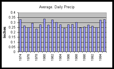
The development of a drainage system capable of efficiently transporting increased runoff and pollutants from impervious surfaces expands the contributing source area in an urbanizing watershed. Falk and Niemczynowicz (1978) identified impervious surfaces as the most important contributors to flows in an urban area. Pitt (1979) found that directly connected impervious areas contribute most of the runoff flows and pollutants during small rains that are of most concern for water quality studies. Pervious surfaces were found to contribute substantial flows and pollutants after about 0.4 to 1.0 inches of rain. Preliminary analysis of 25 years worth of daily precipitation data gathered at the Tri-City Water Pollution Control Plant (WPCP) indicates the most common storms in the area (72%) are less than 0.35 inches in size (averages derived from all non-zero values only - Figure 3).
Figure 3.
Change in contributing area
Increasing amounts of impervious surface and therefore, expansion of surface water runoff contributing area is an inevitable by-product of urbanization. An analysis of the level of connectivity (i.e. that portion of the watershed that is either directly or indirectly connected to the stream network) was conducted in an effort to estimate the change in the amount of contributing area within the basin that has occurred in the last 22 years. An increase in the amount of area contributing runoff can result in downstream flooding if the existing storm water infrastructure is inadequate.
The focus of the surface water master planning effort for the Mt. Scott basin was the identification of both the potential problem areas in the existing network and potential site locations for sub-regional detention facilities. The location and design specifications of combined sub-regional detention and water quality facilities within the basin must address both the environmental impacts of increasing development and the down-stream impacts of increased runoff and pollutant loads.
Analysis of land use change and development pattern
A landscape level analysis of the land use changes that have occurred in the Mt Scott watershed since 1976 was performed utilizing ARC/Info GIS software, land use data and aerial photography. Current land use data and 1998 digital orthophotos were used to classify taxlot polygons into six land use categories (Table1). The classified polygons were checked using the 1998 digital photography and updated based on known locations of more recent development. An ARC/Info coverage of the 1976 land use pattern in the basin was created utilizing scanned and rectified 1976 aerial photography and taxlot polygons. Taxlot polygons were attributed using the aerial photography as a background image. Field personnel provided additional information to facilitate the correct interpretation of the scanned imagery.
Land use in the watershed has shifted from primarily forested areas (22% in 1976 to 16.7% in 1998) and agricultural fields (49% in 1976 to 3.3% in 1998) to residential neighborhoods on one-half to one-quarter acre lots (12% in 1976 to 52% in 1998).
| Land-use |
|
|
| Unknown |
|
|
| Commercial |
|
|
| Industrial |
|
|
| Farm/tract |
|
|
| Forest |
|
|
| Multi-Family |
|
|
| Roads |
|
|
| Residential |
|
|
Table 1.
Each land-use category was then assigned an impervious surface percentage utilizing a classification scheme developed by the Portland Metropolitan Area Regional Development Council - METRO (the publicly elected regional planning council for the Portland metropolitan area). An area weighted impervious surface percentage for the entire watershed was then calculated.
Percentage of impervious surface has been recognized as a key indicator of impacts to watersheds due to urbanization. Arnold & Gibbon (1996), discussed the two major advantages of impervious surface as an environmental indicator. First, it is measurable and readily estimated. Second, impervious surface is a major component of pollutant-generating land uses as well as a principal contributor to hydrologic change in a watershed. According to Schueler (1994), the percentage of impervious surface is an indicator of stream channel stability and stream health and correlates highly with urban watershed pollutant loads.
The land-use change analysis
performed for the Mt Scott watershed showed that impervious surface area
for the watershed as a whole was approximately 12% in 1976 and is currently
estimated at 30% reflecting a 100% increase in the amount of impervious
surface in the watershed in the last 22 years (Table 2).
| Land Use Class |
Impervious
Surface Percentage
|
| Commercial (vacant) |
5%
|
| Commercial (non-vacant) |
90%
|
| Industrial (vacant) |
5%
|
| Industrial (non-vacant) |
90%
|
| Farm (vacant) |
5%
|
| Farm (non-vacant) |
20%
|
| Forest |
5%
|
| Multi-Family |
65%
|
| Roads (buffered to 30' width) |
90%
|
| Residential 0-.25 ac |
35%
|
| Residential .26-.5 ac |
30%
|
| Residential .6-1 ac |
25%
|
| Residential > 1 ac |
20%
|
Loss of wetland and riparian habitat
Numerous studies have found that wetlands are essential for healthy hydrology and the ecology of watersheds. Wetlands prevent floods, cleanse waters, and recharge ground-water aquifers. They retain nutrients and other pollutants which are then incorporated into the wetland biomass (Kadlec and Hammer, 1980; Nichols, 1983, Watson et al., 1989). Studies by Oberts (1982) documented that nutrient exports from watersheds with a significant amount of wetland area (10% to 20% of the total area) were much lower than the export from watersheds where the wetlands were drained. Wetlands are also ecological assets due to their provision of habitat for waterfowl, animals, and vegetation.
Research indicates that riverine wetlands and adjacent floodplain form natural corridors in which floodwater is stored and held back. Plausrine wetlands that receive surface runoff from a surrounding watershed will attenuate the runoff peaks (Novotny 1994). These characteristics and abilities make wetland areas especially important assets in urbanizing watersheds.
The METRO regional planning council recently approved the requirement of vegetative buffers along stream courses and around wetland areas in all watersheds in the metropolitan area. The so-called "Title 3" buffer widths vary dependent on several factors including presence of adjacent steep slopes and/or the amount of area being drained by the sensitive feature (i.e. wetland or stream reach).
Much of the Mt. Scott watershed was developed with minimal buffer requirements (25 feet in most cases). In an effort to analyze the amount of riparian and wetland habitat that has been lost to development over the past 22 years, current landuse was overlaid with these newly required buffers. Analysis indicates that 160 acres of now protected riparian and wetland habitat has been impacted by development. This equates to roughly one-half of the area now protected by vegetated buffers in the watershed.
Much of the Title 3 -buffered wetland areas are located in the upper reaches of the watershed, which is currently under-going rapid development. The protection these wetland areas offer to the downstream sections of the creek in terms of mitigating flows is essential to maintaining the current level of aquatic health and channel stability in the watershed.
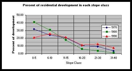
Development on steep slopes
A time-trend analysis indicates that as the watershed moves closer to full built-out conditions, more residential development is taking place on steeper slopes (Figure 4). Where residential development has already taken place in the steeper sections of the watershed, an elaborate network of French drains, detention pipes and retaining walls have been built in order to effectively deal with the amount of surface and sub-surface drainage taking place. These neighborhoods are characterized by large homes on small lots with very little pervious surface area remaining.
 Figure
4.
Figure
4.
Connectivity and contributing source area
The concept of variable source area contribution as applied to natural watersheds suggests that the amount of surface area that is hydrologically active (i.e. generating surface runoff) is directly related to the recurrence interval of the storm. The hydrologically active area will be smaller for storms with a small recurrence interval and will increase with the magnitude of the storms and their recurrence interval (Novotny, 1994). This concept applied to urbanizing areas would suggest a direct relationship between the amount of surface water runoff generated and the amount of impervious surface present.
During common small rains, directly connected impervious surfaces contribute much of the flows and pollutants to an outfall (Pitt, 1979). Impervious surfaces that drain across adjacent pervious surfaces and subsequently, into soils are considered to be partially connected or not connected dependent upon the length of the pervious surface, soil type and length of travel path.
In order to estimate the change in contributing source area since 1976, the impervious surface percentage of each land use polygon was classified based on its level of connectivity to the stormwater network or receiving water system. Forest and farmlands within the watershed were considered disconnected. Industrial areas were classified as directly connected based on detention requirements that were in place at the time most of the facilities were built. Commercial properties were classified as partially connected. All roads within the watershed were buffered to 30-foot widths and classified as partially connected. Residential areas served by detention pipes were classified as directly connected while areas served by on-site detention ponds and those having no known detention facility were classified as partially connected.
Classifying areas served by on-site detention as partially connected is a conservative approach. The Mt. Scott watershed is dominated by clay soils with marginal to poor infiltration characteristics due to low permeability, high water table mainly during the winter months, shallow soil, or steep slope. Field observations indicate that stormwater exiting on-site detention ponds often travels for short distances across open channels with a clay substrate before outfalling into the main receiving water system (i.e. Mt. Scott creek or tributary streams).
Pitt (1979) suggests that impervious surfaces draining to pervious areas obviously lose additional runoff before the flow reaches the drainage system. Most of the impervious area runoff could be lost to infiltration if it flows over long pervious drainage paths while little additional infiltration would occur if the drainage path were relatively short. Clay soils with a clay hardpan or clay layer at or near the surface require either a longer flow length over pervious areas or relatively small impervious to pervious area ratios for significant infiltration losses to occur.
Results of the connectivity analysis of the Mt. Scott watershed for both the 1976 and 1998 landscapes indicates that approximately 12% of the 1976 landscape was either directly or partially connected to the surface water drainage network. In 1998 the level of connectivity rises to approximately 28% of the total watershed area (4.7% directly connected and 23.3% partially connected). Given the soil types and slope characteristics of the watershed, the total amount of directly connected contributing area in the watershed could potentially be much greater.
Given the level of connectivity now present in the basin and the expectation of continued development, it is critical to identify existing and potential surface water conveyance problem areas and to find possible location for sub-regional detention facilities.
In 1995, WES began the process of developing a surface water master plan for several basins including the Mt Scott creek watershed. The focus of the project was to identify existing surface water conveyance problem areas, (given a full build-out scenario) and propose locations for CIP projects. These projects would be designed to provide adequate conveyance capacities and propose strategic locations for sub-regional detention/water quality facilities that would help mitigate the impending consequences of continued development within the watershed.
Surface Water Master Plan
and XPSWMM Modeling
XPSWMM Model
The Environmental Protection Agency (EPA) XPSWMM model (Huber and Dickinson, 1988) was used to compute the flows for the 2-, 5-, 10-, 25-, 50-, and 100 year recurrence interval storm events for the Mt. Scott Creek watershed. The model was run under current land use conditions and using a full build-out scenario based on METROs 2040-development plan. Several flood control and water quality facility alternatives were analyzed using the model.
The SWMM model employs both the standard Soil Conservation Service (SCS) method for rainfall-runoff computations and a simulation routine for hydrologic accounting (MSSWMP, 1997). This simulation is appropriately applied to developed or developing areas and as such, is well suited for use in the Mt. Scott watershed.
Catchment Delineation
ARC/Info GIS was used to develop the spatial data layers needed to run the XPSWMM model. The catchment areas within the watershed were delineated using two-foot contour maps, land use, hydrology, and the existing storm sewer network. For this study, catchment areas averaged approximately 50 acres in size. Delineating the basin at this level allows the individual hydrologic characteristics of each catchment to be defined (Figure 4). Each catchment was characterized with parameters that define how surface water flows into and out of, the system. The SCS method was used to generate an individual storm flow hydrograph for each catchment. These hydrographs were then merged to form one hydrograph for the whole system.
Design Storm Criteria
Total 24-hour rainfall volumes for each of the storm recurrence intervals (2-, 5-10-, 25-, 50-, and 100 year) were determined from National Oceanic and Atmospheric Administration (NOAA) isopluvial maps. Isopluvial maps depict the volume of rainfall over a 24-hour period for a given geographic area. The SCS 1A rainfall developed for western Washington and Oregon was used due to its widely accepted use in the sizing of conveyance facilities.
Impervious surface and land use
One of the primary factors that increase flow as an area becomes developed is the overall percentage of impervious surface. The higher the percentage, the larger the volume and intensity of runoff. Impervious surface percentages were calculated based on current and 2040 projected land use. Corresponding curve numbers further define the flow patterns for both pervious and impervious surfaces. These values were determined from SCS tables that relate runoff curve numbers to soil types and land use conditions. The soil types were determined from SCS soil maps for Clackamas county and a GIS-based soils layer. These data combined with calculations made to estimate time of concentration for the basin under both existing and future land use conditions provided all of the hydrologic parameters needed to calculate the area's flow volume, flow pattern, and timing and size of flow peaks.
Hydraulic Analysis, Detention Storage and Pollutant Reduction Potential
The hydraulic components of a stormwater system include the pipes, ditches, and open channels that convey water out of the system. Partial coverage of the existing stormwater network was already in GIS. This network coverage was combined with a field survey of pipes/culverts 15 inches in diameter or larger and measured cross sections of channels in the primary routing system. On average cross sections were taken every 200 feet. Data collected for each pipe included material, length, diameter, upstream and downstream inverts, upstream and downstream elevations and general condition (MSSWMP, 1997).
For the model analysis, detention storage was analyzed by incorporating storage nodes with stage discharge curves based on the orifice equation. Pollutant loading and reduction potential at the pollutant reduction facility options were evaluated using the storage/treatment block of the XPSWMM model (MSSWMP,1997).
Model Results and Identification of CIP projects
Three alternatives for reducing flooding problems and addressing water quality were evaluated based on their cost and technical feasibility. The preferred alternative takes advantage of maximum detention in the upper basin. This is critical to achieve a reduction in potentially severe downstream flooding that may occur as maximum build-out is achieved. A total of 22 CIP projects were identified in the Mt. Scott creek watershed (Figure 5). The projects were designed to either: improve existing conveyance capabilities where problems currently exist or have the potential to exist given the full build-out scenario employed; retro-fit onsite detention facilities to enhance their water quality benefits, or provide sub-regional detention to areas of the watershed that are projected to see increased development. The proposed sub-regional facilities would provide detention during rare flood events and could be combined with either a pollutant reduction facility or provide recreational benefits during low flow.
The advantages of detention facilities include the reduction of costs for conveyance systems downstream, the potential for dual use, and mitigation of the effects of higher peak flows due to urbanization. In a fully developed watershed, the opportunities for locating sub-regional detention facilities are fairly limited due to a reduction in the availability of large tracts of land. All proposed sub-regional detention facilities were located based on several factors including the amount of area that could be served, topography and availability of land.
Evaluation of the continued viability of identified CIP projects
Eleven of the 22 identified CIP projects may no longer be viable based on the findings of the landscape level analysis (CIP 's,15, 20,25,50,55,85,90,95, and 135). The eleven proposed projects would either encroach upon current Title 3 buffers or, they are designed as in-line structures, or both. In-line or "in-stream" structures often act as barriers to fish passage and may no longer be a viable alternative given the recent federal listing of Steelhead and Chinook salmon in the Lower Columbia and Willamette River ESU's. Encroachment of Title 3 buffers is allowed where no reasonable or feasible option exists. Whether or not these projects would qualify for an exception to the "no encroachment" rule would have to be decided on a project by project basis.
Two of the conveyance improvement projects (CIP #'s 90,85) involve widening of natural channels to improve conveyance capacity. The benefits of these projects in terms of increased capacity may have to be weighed against the potentially detrimental effects of altering natural channels.
Proposed sub-regional detention facilities
Sub-regional detention facilities in the upper basin are still necessary and desirable given the level of channel incision and sediment deposition occurring in many of the downstream sections of Mt. Scott creek and its tributaries. The detention/water quality facility that has been proposed for the Happy Valley Park area (CIP #5) is still a viable alternative because it does not overlap with Title 3 buffers nor is it designed as an in-stream structure. This facility would be located below an area that is scheduled for development. The facility is proposed as a conjunctive use detention/water quality facility that would provide important peak flow reductions for a 295 acre drainage area, which forms the headwaters of Mt. Scott creek. A forebay on the upstream end of this facility would allow for good suspended solids removal by slowing flow velocities enough for the suspended solids to settle out. Flows from adjacent development could also be routed through this facility. The surface area required would be approximately 3 acres with a maximum depth of 5 feet (MSSWMP, 1997).
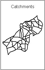
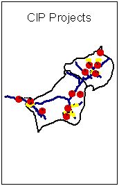
Figure 4. Figure 5.
CIP #60 is designed as a retrofit of an existing off line detention facility. This facility is located in an adjacent basin just above the confluence of Mt Scott and Phillips creeks. The current facility was designed as to detain flows in exceedance of the 10-year storm event along Phillips Creek. Changing the size of the orifice to provide a 2-year pre-development release rate and providing detention for a two-year and greater event could enhance the efficiency of the facility. The facility could also be used in conjunction with the North Clackamas Regional Flood Control facility (NCRFC) for better downstream flood management. The NCRFC is downstream from the confluence of Phillips and Mt Scott creek and is 87 acres in size. This facility provides detention for a 17-year storm event with a storage capacity of 112-acre feet.
Three of the remaining CIP
projects are designed as retrofits to existing on-site detention facilities
(#'s 27,40,30,45). Currently, these facilities are providing little if
any detention or water quality benefit due to either their design specifications
or lack of maintenance. The proposed retrofits include the development
of a forebay on the upstream end of the facility, excavation for increased
detention and the maintenance low flow velocities (to enhance solids removal).
The detention and water quality benefit of these facilities would be improved
if they were retrofitted with a control structure designed to regulate
flow to a 2-year pre-development release rate. Regularly scheduled maintenance
of these facilities is key to preserving the water quality benefits that
would be gained at these sites.
Conclusions
Over the past twenty-three years, the Mt Scott watershed has been transformed from a rural watershed dominated by agricultural fields and forest to an urban area. During that process wetlands have been drained and filled, riparian areas and streams have been culverted, piped, and covered over with sidewalks, streets, and residential neighborhoods. As a result, a significant portion of all incoming rainfall is converted directly into surface runoff, which flows rapidly and expeditiously via an elaborate storm sewer network into Mt. Scott creek and its tributary channels. These channels are now eroded and incised in several locations. Although an adequate amount of salmonid spawning substrate does exist within the creek, the dominate fish species present are those that are tolerant of high temperatures, sedimentation, and organic pollution.
In the lower reaches of Mt Scott creek, the accumulated storm water flows have severely incised the channel, covered the creek bed with layers of fine sediment and dumped tons of urban refuse and garbage. Water quality sampling at various locations within the watershed shows a trend toward increasing loads of urban pollutants including nutrients and heavy metals. Continued development will only add to decline of the aquatic habitat within the watershed unless attempts are made to refine detention requirements and provide water quality treatment of the urban runoff generated within the watershed.
On-site detention facilities within the basin currently are designed to allow flows generated from five-year return interval storms and smaller (3.2" in 24hrs.) to pass through unimpeded. Analysis of local precipitation data indicates that the majority of the storms that occur within the basin (72%) are .35 inches or less (based on daily precipitation data). Based on this information it is possible to conclude that the majority of the surface runoff that is generated in the basin is flowing unimpeded into Mt Scott creek and its tributary streams.
WES recently revised on-site detention rules and regulations in newly developing areas to require two-year pre-developed release rate and one-half of the two-year pre-developed release rates in problem areas. Whether or not these revised regulations will be more effective at detaining surface water runoff remains to be seen. The results of the analysis of localized precipitation data indicate that WES's water quality and detention rules and regulations would be more effective if they were geared toward detaining and providing treatment for the more common small storms (less than 0.4 inches in 24hrs) that contribute relatively higher amounts of pollutants and flows in the watershed.
Water Environment Services
is responsible for surface water management in northern Clackamas County.
As the urban area within the county continues to expand, so will the challenges
of surface water management. By working directly with the Clackamas County
Planning department to develop innovative ways of providing adequate housing
and services while minimizing the amount of urban runoff generated, WES
could more effectively integrate the management of surface water with the
protection of aquatic health in urban streams.
RECCOMENDATIONS
References
Kedlec,R.H.,and Hammer,D.E., "Wetland Utilization for Management of Community Wastewater," 1979 Operations Summary, Houghton Lake Wetland Treatment Project, NTIS PB80-170061, February 1980.
Nichols, D.S., "Capacity of Natural Wetlands to Remove Nutrients from Wastewater," Journal of the Water Pollution Control Federation, 1983.
Watson, T.J., Reed, S.C., Kadlec, R.C., Knight, R.L., and Whitehouse, A.E. "Performance Expectation and Loading Rating for Constructed Wetlands," Constructed Wetlands for Wastewater Treatment: Municipal, Industrial and Agricultural, Lewis Publishers, Chelsea, Mich., 1989.
Oberts,G.L.(1982) "Impact of wetlands on nonpoint source pollution", in Proceedings, International Symposium of Urban Hydrology, Hydraulics and Sediment Control, University of Kentucky, Lexington, KY., pp. 225-231
Novotny,V (1994), Water Quality Prevention, Identification, and Management of Diffuse Pollution Van Nostrand Reinhold, New York.
Kellog-Mt.Scott Creeks Surface water master plan, July 1997.
McCuen, R.H., "A Regional Approach to Urban Stormwater Detention," Geophysical Research Letters, 72-128, pp.321-22, November, 1974.
Urbonas, B.R., Glidden, M.W.,
"Potential Effects of Detention Policies," Proceedings of the Second Southwest
Regional Symposium on Urban Stormwater Management, Texas A & M University,
November, 1983.
Authors Information
Carol Murdock - Systems Resource Specialist, Water Environment Services, 16770 SE 82nd Drive, Suite 200,Clackamas, OR 97015, (503)557-6462, FAX (503)650-3026
Catherine Neumann Phd. - Department of Public Health, Oregon State University, Corvallis,OR.
Jim Burch - Surface Water Technician, Water Environment Services, (503)557-6493.
Karen Streeter - Surface Water Technician, Water Environment Services, (503)557-6468.