Shuk-Han MAK
Identify Sites for Accommodating Open Storage Uses: A GIS-based Modeling Approach
ABSTRACT
In the last decade there has been dramatic changes in the rural landscape of Hong Kong. One of most evident changes is the frenetic conversion of fallow fields into open storage uses. Open storage uses are referred to those massive materials along the highway, or on idle agricultural land or in filled fish ponds. About 50% of an open storage site is uncovered and used for the deposition of containers, construction materials, scarps and wrecked cars. These materials are not unwanted but just too space consuming to be accommodated in warehouses located in urban areas. The huge profits in leasing the land and the low agricultural returns have rendered many landowners to sublet their paddy fields and farmlands in serving such a purpose. The sprawl of these activities has destroyed the rural beauty of the landscape and impinged on areas of ecological importance. However, these uses cannot be simply eradicated because the excessive demand for storage space is an inevitable consequence of the economic activity of Hong Kong. More practical approach is to accommodate these tipping materials in a designated area where better provisions are facilitated to manage and organize them. In this regard, GIS will be used to examine, analyze the problems associated with open storage operations; further, a GIS-based model will be used to simulate a site-selection process for identifying permanent sites to accommodate the open storage uses.
The Extent of Open Storage in the Rural Area of Hong Kong
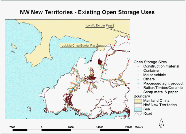
The sprawl of the open storage uses causes an eyesore to most rural part of Hong Kong especially the NW New Territories. The locations of the operations are more related to population concentrations or construction sites. Concentration is usually found in near the Pat Heung area when the two major roads, Fan kam and Lam Kam, converge. In most regions of NW New Territories, the proliferation has mostly occurred in ribbon form along main roads, especially those network connecting two major border passes (between Hong Kong and Mainland China): Low Wu and Lok Ma Chau Pass (Figure 1). It is therefore concluded that easy accessibility for these trucks to load and unload tipping materials is a vital condition to these open storage operations. The Open storage uses can be roughly classified into seven types including construction material, container, motor vehicle, processed agricultural product, rattan/timber, scrap metal and others. The region has taken almost a total of 353 hectares for open storage uses (Figure 2).
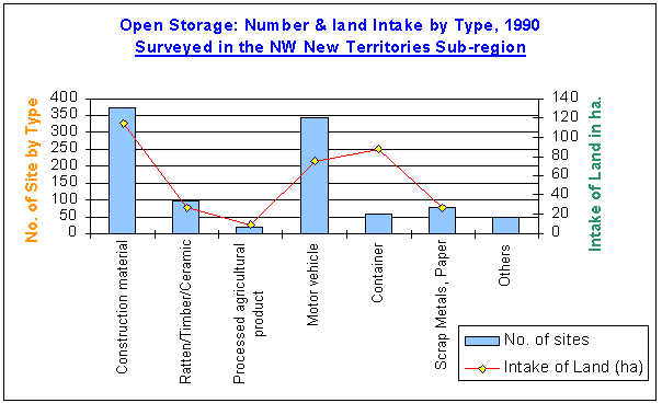
Figure 2 The number and the intake of open storage uses by their types
GIS-Modeling Approach for Site-selection Process
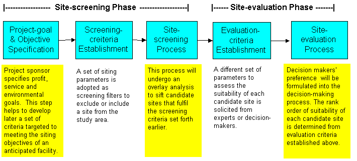
As one can see, there are different types of open storage uses and each type is associated with a different set of siting requirements. The objectives and criteria involved in siting of one type of operations will be different from those in other setting. Therefore, it is advisable to settle them all under one roof. The challenge here is to develop a universal site-selection procedure that is general enough to accommodate for individual differences and particulars. In urban planning, site-selection is a frequent decision-making exercise for a wide range of activities; ranging from locating nuclear power plant to individual home purchase. Unlike many planning tasks that a regular handling method is not available, site-selection practices are fairly standard regardless of the situations and the nature of the tasks. The process, typically, involves two main processes (Findikaki, 1990; Williams & Massa, 1983; Zyma, 1991; Keeney, 1980):
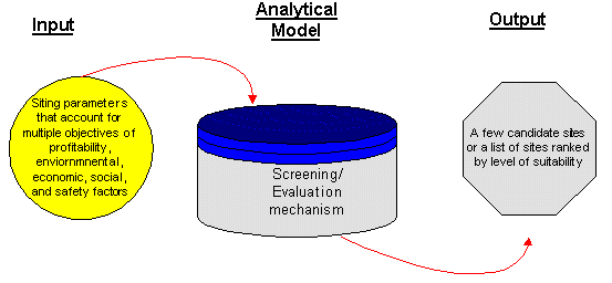
Site-screening phase that identifies a small number of candidate sites from a broad geographic area and range of factors; and
Site-evaluation phase that examines each candidate sites in depth in search of an optimum site.
It was also found that siting procedures, in a computerized setting, mostly employed GIS in phase 1 to screen a list of suitable sites (USGS, 1996; Murata, 1996; Cargin and Dewyer, 1996). Likewise, multi-criteria decisions making (MCDM) and related decision methods were employed to discriminate an optimum site in phase 2. This general practice is justified by the fact that GISs provide a feasible means of managing spatial databases while MCDMs furnish capabilities to soliciting values, preferences and risk attitudes from decision-makers to launch a more objective decision (Sarin, 1980; Mills, 1989; Aubert, 1986). The integration of GIS and MCDM has been an active research area in facilities siting exercises (Janssen and Rietveld, 1990; Pereira & Duckstein, 1993; Jankowski & Richard, 1994). However, these studies concentrate largely on the technical aspects of the integration; tend to overlook the modeling process that guide the users in their choices of criteria for selecting a site, nor give advises for the course of action in the searching process (Fischer & Nijkamp, 1992; Goodchild, 1991; Openshaw, 1990). A site-selection model is proposed here to integrate the two methodologies and also provide a systematic guidance to run the siting process.
The two phases, namely, the site-screening and site-evaluation, can be seen as two independent input-output models (Figure 3). The input-output model is an open system that commands a defined set of data in a fixed input and output format. The inputs to both the site-screening and site-evaluation model are those siting criteria that are used to measure the suitability of an ideal site. The system itself undergoes a series of actions such as the overlay analysis for a series of screening-models and the MCDM process for supporting siting decision, that would eventually generate one or several site alternatives as the output(s). The input parameters, dictated by different scenarios of siting objectives and conditions, would lead to a dissimilar set of output locations. Proper operation of the model, therefore, hinges on a thorough and factual establishment of the goal and objectives of the siting project on the outset.
Figure 3 An input-output model for facilities siting
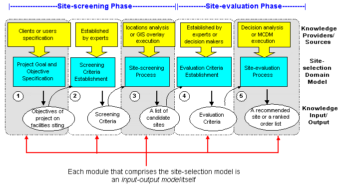
Goal, objectives, criteria and corresponding siting processes all lock in a closely related process forming the site-selection model. The formulation of goals (towards which efforts and resources are directed) and objectives (the more precise and measurable steps needed to achieve the goals) are translated into inexact criteria that correspond to existing or acquirable map data. The set of criteria would then be used as inputs to fuel up the two siting procedures (namely, the site-screening and the site-evaluation) to generate solutions that satisfy stated goals and objectives. In this regard, the author envisages that the site-selection process is a model of five clearly identifiable modules as illustrated in Figure 4.
Each stage of the site-selection process is an independent module itself commending a fixed set of input and output knowledge. Incidentally, the knowledge input of one module is the knowledge output of the preceding module. The site-selection model is able to support three types of functions: 1) The model represents as a framework to secure essential steps in undertaking the siting task. 2) The site-selection model entails a knowledge acquisition (KA) paradigm that enables the landuse planners to follow to develop their knowledge into the system. The elicited knowledge can be retained in the system for further justification or for consultation when retrieval. Along the same line, 3) novice users could also follow the same terms and relationship to obtain the required knowledge as the reference to their own siting problems. Figure 5 and the subsequent paragraph would illustrate how these five modules carry out these functions with the emphasis on the input and output knowledge of the model.
Interfacing Siting Knowledge to the site-selection model
The site-selection model on the whole represents a conceptual model that brings the users and the system into interaction. However, it is only a structural and functional definition of the process itself. It is rather skeletal in nature and does not infer any concrete (or operation) knowledge to fuel up the site-selection process. This implies that the model needs to be instantiated. The instantiation of the knowledge will rely on some tools to interface more precise and ‘operational’ knowledge from recognized sources and field experts. These tools or interfaces, called here as KA tools, allows the site-selection model to run routine tasks while acquiring more refined knowledge for individual cases.
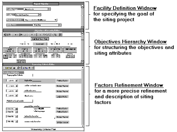
The main KA tools interfacing to the domain model is a form-filling scheme which emulates a "paper and pen" environment, in which the planner enters strings and numbers into fixed fields on the screen and selects primitives from option boxes. Form-based interface is an intuitive method to leverage large amount of knowledge (Gruber & Cohen, 1988; Musen et al., 1987; Sinclair, 1990), as the user can simply uses the mouse or cursor to move between fields and modify data as he wishes. The site-selection model serves as a graphic menu that enables users to pass easily between the modeling environment to the form-based environment in furnishing details. Knowledge solicited from these declarative forms will be stored as an individual case and collected in a centralized database. Figure 6 shows how the site-selection model interfaces to different declarative forms. There are totally three types of declarative plans: The Project Definition form extended from the module of Project-goal & Objectives Specification, the Screening-criteria Form from the module of the Screening-criteria Establishment and the Evaluation-criteria Form from the module of Evaluation-criteria Establishment. These forms are further discussed below.
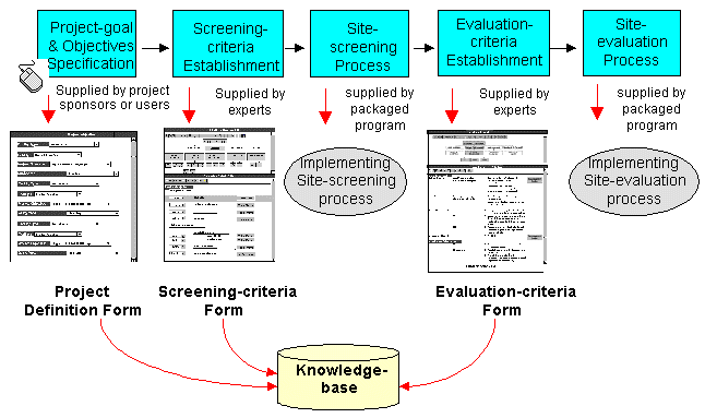
Figure 6 The site-selection domain model allows the user to pass easily between the modeling environment and the forms-based part of the system. By using the mouse, the user can invoke an appropriate form to instantiate the required details there. Three types of form are specified here: Project Definition Form, Screening-criteria Form and Evaluation criteria form.
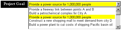
Project Definition Form
Project Definition Plan is mainly for the landuse planners or the project sponsors to define the goal and objectives of their project. The role of this form resembles the conventional Project Definition Plan, which is generally adopted in many facilities planning (William & Messa, 1983). Such a plan provides information on the characteristics of the facility like the facility type, the size, the capacity, the service scope and the siting requirement (Minnesota Environmental Quality Council, 1978). It serves as a blue print for the later development of the proposed facility.
This form-filling interface corresponds to a "filling-the-banks" interface. The left part prompts the user's answer on the right part. The entry is often assisted by dropdown list so the user does not require creating answers from the void. If his desirable answer is beyond the fixed list of items, he can often pick up the closet option and modify the content but keep the syntax of the primitive. As illustrated in Figure 7, the user selects the project goal from a list of given options.
Screening Criteria Form
In the Screening-criteria Form, planners are asked to formulate a set of screening criteria in defining the suitability of eligible sites. The criteria form attempts to find a reliable model to establish the multiple, related objectives and criteria in a model that landuse planners will use. Hereby a hierarchy structure is used to organize a random or sequential list of siting criteria in a hierarchy on the outset and then match these criteria to existing or acquirable map data. The intent of this approach is accomplished by three viewing Windows (Figure 8) in the screening-criteria form:
Figure 8 The Screening-criteria Form combines three viewing windows: the project definition, the Objective Hierarchy and the Factors Refinement.
If the area is higher than 1000 ft,
Then the area is not a candidate for a container back-up site
A transparent program would translate it into a symbolic notation called frame:
(Rule x (AKO ($Value (Preprocessing_Rule)))
(Precondition ($Value (> area_relief 1000)))
(Consequent ($Value(Eliminate_candidate))))
When the knowledge is expressed declaratively as a segment of rule, both the experts and users could make changes to the segment or update it without affecting the entire system. Also, the subsequent model (i.e. the site-screening process) could understand it and run the requested procedure. Such a knowledge representation allows algorithms, strategic knowledge and problem-solving strategies to interact in a more intricate manner that facilitates both system automation and the process of knowledge acquisition.
Benefits of the GIS-based Modeling Approach
GIS is capable to formulate a variety of development scenarios, a series of ‘what ifs’ can be rapidly updated and changed to accommodate the opinions and interests of different concerned groups. However, it often lacks the facility to support an objective assessment in choosing the best site. MCDM is able to fill up the gap by assisting the decision-maker in selecting the best alternative among a number of feasible choices. The proposed GIS modeling approach is able to integrate these two methodologies to simulate a process of site-selection. Moreover, the model is able to accommodate a wide range of siting projects, and, at the same time, allow rooms for maneuvering individual cases. This approach is demonstrably superior for those projects with diverse siting objective like the open storage uses. Further, the land use planners can now render their knowledge directly into the system and their knowledge and reasoning of selecting the criteria can now be retained in the system. The retained knowledge can also be retrieved for open scrutiny or awaiting for further justification, and the knowledge represented there can be advice to novice user in their choice of siting criteria for defining the searching scope.
Conclusion
The analysis presented in this thesis is a modest beginning in an attempt to understand the task and the task elements involved in the site-selection process. Much work remains to be done especially in the area of implementation. For example, this research has not discussed the methods or programs used for transforming the strategic knowledge from its declarative format into an operational format. The research has not dealt with the technical integration of various standalone systems including GIS and MCDM system. However, with advances in software engineering and a wide range of full-blown commercial shells, the implementation details could be left to application programmers who can identify and develop these computational modeling in a more efficient and proficient manner. The author, take a formal analysis of the site-selection process, and from there, discover "chunks" of knowledge that can be formulated into concepts, processes, definitions or relations. This discovery would lead to the development of a universal site-selection routine that enables human planners to apply it to their site-selection tasks.
Reference
Aubert, P. J. (1986). The Siting of Nuclear Power Plants in the Netherlands: on the Possible Use of Multicriteria Decision Methods in energy Policy. Energy Science Project, Department of Inorganic Chemistry, State University of Utrecht, the Netherlands.Cargin, J. & Dwyer, 1996). J.
Pennsylvania’s low-level radioactive waste disposal facility siting project: data in,
data out.
http://www.Esri.com/resources/userconf/proc95/p036.html. Retrieved
on May 24, 1996,
Findikaki, I. (1990). SISES : An expert system for site selection. In J. R. Wright, L. L. Wiggins, R. K. Jain & T. J. Kim, Eds. Expert Systems in Environmental Planning, pp. 125-131. New York: Springer-Verlag.
Fischer, M. M. & Nijkamp, P. (1992). Geographic Information Systems and spatial modelling : potentials and bottlenecks. In J. Harts; H. Ottens & H. Scholten, Eds. EGIS ‘92, Proceedings of the Second European Conference of Geographical Information System, pp. 214-225. Utrecht: EGIS foundation.
Goodchild, M. F. (1991) Progress on the GIS research agenda. In A. Harts; H. F. L. Ottens & H. J. Schoten, Eds. EGIS’91, Proceedings of Second European Conference on Geographical Information Systems, 1, 342-350. Utrecht: EGIS Foundation.
Gruber, R. T.; Cohen, P. R. (1988). Design for acquisition: principle of knowledge-system to facilitate knowledge acquisition. J. H. Boose and B. R. Gaines, Eds., Knowledge acquisition tools for expert systems, pp. 131-147. London; San Diego: Academic Press.
Keeney, R. L. (1980). Siting Energy Facilities. New York: Academic Press.
Mills, N. L. (1989). A multi-phase approach to site selection. Site-selection and Industrial Development, 158(3), May/June, 769-773.
Minnesota Environmental Quality Council, (1978). Visual Sensitivity of river Recreation to Power Plants, prepared with EDAW Inc., April.
Musen, M. A.; Fagan, L. M.; Combs, D. M.; Shortliffe, E. H. (1987). Use of Domain model to drive an interactive knowledge-editing tool. International Journal of Man-Machine Studies, 26, 105-121.
Murta, M. (1996). A GIS application for power
transmission line siting.
http://www.Esri.com/resources/userconf/proc95/p061.html.
Retrieved on May 24, 1996.
Openshaw, S. (1990). A spatial Analysis Research Strategy for the Regional Research Laboratory Initiative. Regional Research Laboratory Initiative Discussion Paper No. 3. Newcastle-upon-Tyne, UK: University of Newcastle-upon-Tyne.
Sarin, R. K. (1980). Ranking of multi-attribute alternatives with an application to coal power plant siting. In G. Fandel and T. Val, Eds. Multiple Criteria Decision-making: Theory and Application. Proceeding of the Third Conference on Multicriteria Decision-making, Hagen/Konigswinter, West Germany, 1979. New York: Springer-Verlag.
Sinclair, M. A. (1990). Subjective assessment. In J. R. Wilson & E. N. Corlett, Eds., Evaluation of Human Work: A Practical Ergonomics Methodology, pp. 58-88. London: Taylor &Francis.
Schaenmann, P. S.; Muller, T. (1974). Measuring
Impacts of Land Development: an Initial Approach. Washington: Urban Institute.
USGS (1996). Site selection. http://www.usgs.gov/research/gis/applications3.html. Retrieved on May 24, 1996.
Williams, E. A. & Massa, A. K. (1983). Siting of Major Facilities. U.S.: McGraw-Hill Book Company.
Zyma, R. A. (1991). Performing environmentally sensitive siting studies. Site-selection and Industrial Development, October, 1082-1087.
Shuk-han Mak
University of Hong Kong
Dept. of Geography & Geology,
University of Hong Kong
Pokfulam Road,
HONG KONG
Tel: 852-2859-2311
Fax: 852-25598994
e-mail: annshmak@hkucc.hku.hk