Authors: Tamia C. Rudnicky, Carl Hershner, and Marcia Berman
Preservation Targeting for Wetlands using GIS Techniques - A Model in the Chickahominy River Watershed, Virginia
Tidal and non-tidal wetlands can be associated with a suite of functions and values which they perform in a natural landscape setting. These functions vary in importance depending upon their position in the landscape and the surrounding land use. For land use decision makers, it is critical that individual wetlands be characterized with respect to their values, and targeted for preservation if necessary.
A GIS application was developed which implemented a set of preservation protocols to model the relative importance and opportunity for a wetland to perform any one of five different functions in the landscape. Functions were limited to: sediment control, bank stability, water quality improvements, habitat, and flood control. The application combined land use/land cover data with National Wetlands Inventory information. A set of criteria defined a suite of possible rankings based on wetland type, adjacent land use, position in the watershed, and external factors within the region which may influence the ability of a wetland to perform a function. These criteria were determined with simple GIS techniques. The model output creates a database suitable for land use planners and managers to assist in their planning activities.
The Chesapeake Bay Program Wetlands Initiative is part of a comprehensive plan to identify wetland areas on a watershed basis and to bring local governments and watershed associations together to target the preservation and restoration of key wetlands. This initiative meets some of the provisions of the 1987 Chesapeake Bay Agreement related to protection, enhancement and restoration of the natural resources of the Chesapeake Bay Watershed (Chesapeake Bay Wetlands Initiative Report, 1998). The Chesapeake Bay Program Wetlands Work Group has developed a model that utilizes readily available data to identify potentially important wetlands based on their type and the surrounding land use. The protocol recognizes eight general types of vegetated wetlands (Table 1) and evaluates the potential of each wetland to perform any one of five functions. The functions include water quality improvement, habitat quality, flood buffering, bank stability, and sediment control. A wetland can improve water quality and control sedimentation by acting as a filter slowing the movement of water and allowing sediments and associated chemicals to settle to the ground. The diverse nature of wetlands offer good habitat for many species, providing food and shelter to a variety of migratory birds, threatened and endangered plants, and animals. Wetlands with high quality habitat boast aesthetic merits such as bird watching, hiking, and hunting. Wetlands can intercept storm runoff, slowing the speed and volume of the water and reducing downstream flooding. Bank stabilization is closely tied with flood protection. By reducing storm runoff and flooding, the potential for bank erosion and suspension of sediments is decreased. Wetlands also act as buffers to retard wave energy and reduce erosion of the fastland.
Table 1
General Wetland Types
Estuarine (tidal)
	Estuarine Emergent (EEM) - characterized by persistent emergent vegetation that is erect, rooted, and herbaceous.
        Species generally remain standing until the beginning of the next growing season. Example: Cordgrass
Estuarine Shrub-Scrub (ESS) - characterized by woody vegetation less than six meters tall. Example: Marsh Elder
Estuarine Forested (EFO) - characterized by woody vegetation greater than or equal to six meters tall. Palustrine (inland nontidal) Palustrine Emergent (PEM) - characterized by emergent vegetation, Example: Cattails Palustrine Shrub-Scrub (PSS) - characterized by woody vegetation less than six meters tall. Example: Buttonbush Palustrine Forested (PFO) - characterized by woody vegetation taller than six meters. Example: Red Maple Riverine (in and along rivers) Riverine Emergent (REM) - characterized by wetland habitats contained with a channel. Limited to nonpersistent
emergent vegetation. Examples: Water Lilies, Wild Rice
Lacustrine (associated with lakes) Lacustrine Emergent (LEM) - characterized by wetland habitats contained in a depression or dammed river channel. Limited to nonpersistent emergent and aquatic bed vegetation. |
The goal of the Chesapeake Bay Program is to develop a tool for the assessment of wetlands, and the identification of the most important wetlands for restoration or preservation. This tool needs to be useful as a guide for watershed associations, local governments, planners and developers.
Study Area:
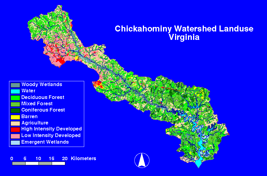
Three watersheds in the Chesapeake Bay where selected to test this assessment tool. The Chickahominy Watershed was chosen to be the test site of the protocol in Virginia. The Chickahominy River discharges into the James River Watershed which drains into the lower portion of the Chesapeake Bay (Figure 1 Study Site Location). It is a principal source of water for the city of Newport News (population 170,000) with a drainage area covering approximately 790 km2. The upper portion of the watershed is primarily forest, residential, and urban with remote areas of agriculture and silviculture (USFWS, 1994). The middle section is predominantly forested with remote sections of agriculture, silviculture, urban, and residential development. The lower portion of the watershed is mainly forested with patches of agriculture, relic fields, and residential development (Figure 2 Chickahominy Land Use).
Methods:
The methodology follows the three phases outlined in the draft January 1998 Chesapeake Bay Wetlands Initiative Report. Phase 1 uses regionally available GIS data bases to assess and score each wetland type on its ability to perform each of the five functions. Phase 2 refines the initial phases by incorporating local scale GIS data. The final phase includes a ground assessment of the wetlands and evaluates the GIS protocol. The first two phases require extensive use of Geographic Information Systems (GIS) techniques, and customized Arc Macro Language (AML) programs to run the protocol in ArcInfo. Eight different AMLs were written to complete the analysis. Several of these AMLs are modified versions of programs developed by Gannett-Fleming (EPA contractor) in Pennsylvania for the previous two pilot projects located in the Hunting Creek Watershed, Maryland, and Lititz Run Watershed, Pennsylvania.
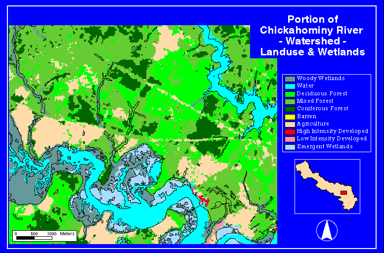
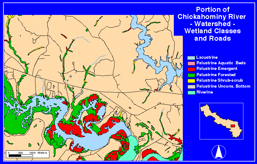
The initial step in Phase 1 of this protocol assembles available GIS data. Wetlands are derived from the National Wetlands Inventory (NWI) database, and serve as the base line data set (Figure 3 Closeup of Land Use and Wetlands). The NWI coverages are mapped to 1:24,000, 7.5 minute USGS quadrangles. Twenty two coverages were appended together to create one seamless data layer and then clipped to the watershed boundary. Other GIS coverages assembled for the protocol include: land use interpreted from Thematic Mapper (TM) satellite imagery (U.S. EPA 1996, multi-resolution land characterization (MRLC)), roads and streams extracted from the 1992 Tiger/Line data (Figure 4 Wetland Classes and Roads), and headwater streams and riparian forest buffers obtained from the Chesapeake Bay Program. A plume coverage delineating an area susceptible to sedimentation and bank erosion was created by intersecting roads and streams.
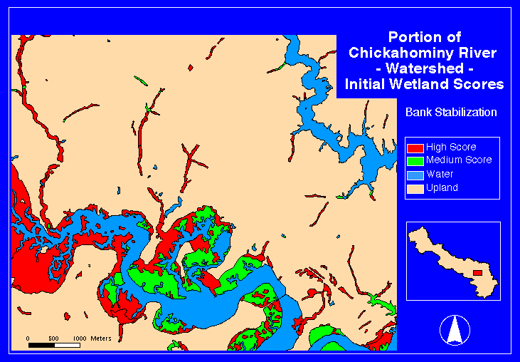
The next step begins the analysis using the AMLs written for the protocol. The first AML creates and adds five new variables to the NWI wetland coverage and scores each wetland on its ability to perform each of five functions: bank stabilization, flood control, habitat quality, sediment control, and water quality improvement. An initial score of 1, 2, or 3 (1 = low, 3 = high) was assigned to each wetland polygon based upon its probable importance of performing a selected function (Table 2) (Figure 5 Original Wetland Scores). Only vegetated wetlands from the NWI data base were selected and scored in this analysis.
Table 2
Probability Scores That a Given Type of Wetland Is Performing a Selected Function
(1=Low, 2=Medium, 3=High)1
|
Wetland |
Habitat |
Water
Quality |
Flood
Protection |
Bank
Stabilization |
Sediment
Control |
| Estuarine Emergent | 3 | 2 | 1 | 3 | 3 |
| Estuarine Shrub-Scrub | 3 | 2 | 2 | 3 | 3 |
| Estuarine Forested | 3 | 2 | 2 | 2 | 2 |
| Palustrine Emergent | 3 | 3 | 2 | 2 | 3 |
| Palustrine Shrub-Scrub | 3 | 3 | 3 | 3 | 3 |
| Palustrine Forested | 3 | 3 | 3 | 3 | 3 |
| Lacustrine Emergent | 3 | 3 | 2 | 2 | 2 |
| Riverine Emergent | 3 | 3 | 1 | 1 | 2 |
1Values were determined by the Chesapeake Bay Program Wetlands Initiative Workgroup.
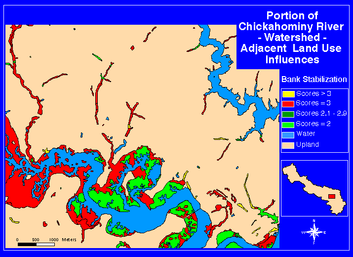
The second step searches for all land use types surrounding each wetland polygon. The original score either remains the same or is adjusted up or down by a value between -0.5 to +0.5 to reflect the influence of the land use on the wetland's ability to perform each function. This step assumes a high degree of functionality is maintained by the wetland. Table 3 shows the functions carried out by the various classes of wetlands at a high level (score of 3 or higher) when adjacent to a variety of land uses. A 3 meter buffer strip around the wetland polygon was intersected with land use coverage. The land use adjustment value for each wetland was determined based on the proportion of different land uses within the buffer. The adjusted scores for each function are written to new attributes in the NWI wetlands coverage. Scores for each function and step are kept separate from the others, because the protocol purposely avoids calculation of composite scores.
Table 3
Wetland Functions* Performed at a High Level
When Adjacent to Different Land Uses
Land Use/Cover -> Wetland Types |
Urban | Residential | Fields | Crops | Forest |
| Estuarine Emergent | B,S | B,S | H,B,S | H,B,S | H,B,S |
| Estuarine Shrub-Scrub | B,S | B,S | H,B,S | H,B,S | H,B,S |
| Estuarine Forested | - | - | H | H | H |
| Palustrine Emergent | W,S | W,S | H,W,S | H,W,S | H,W,S |
| Palustrine Shrub-Scrub | W,F,B,S | W,F,B,S | H,W,F,B,S | H,W,F,B,S | H,W,F,B,S |
| Palustrine Forested | W,F,B,S | W,F,B,S | H,W,F,B,S | H,W,F,B,S | H,W,F,B,S |
| Riverine | W | W | H,W | W | H,W |
*Wetland functions: H Habitat, W Water Quality, F Flood Protection, B Bank Stabilization, S Sediment Control.
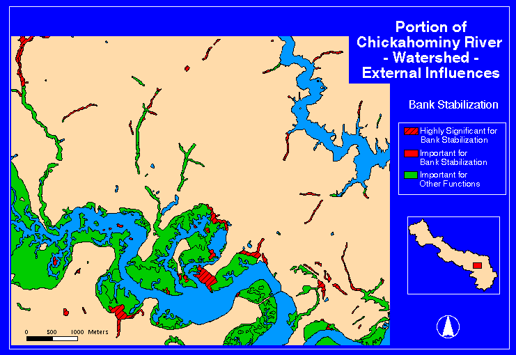
Step three calculates the effects of external influences on wetlands. External influences considered include the proximity of roads, riparian buffers, headwater streams, reefs, submerged aquatic vegetation (SAV), and highly erodible soils (Table 4). Each of these landscape elements are available as GIS coverages. Wetlands falling within predetermined distances of these selected data layers have their scores further adjusted. The adjustment rules and buffer sizes developed by the Chesapeake Bay Wetlands Workgroup are reported in Table 4.
Table 4
Rules for Adjusting Wetland Scores
Based on External Influence Coverages
|
External Influences |
Buffer Size |
Effect on Wetland Score within Buffer Distance |
| Aquatic Reefs | 1 km | +0.5 for Habitat & Water functions |
| Oyster Reefs | 1 km | +0.5 for Sediment function |
Hydrology Plumes dam or road/stream intersection |
1 km
downstream
0.5 km wide |
-0.5 for Bank function |
| Headwater Streams | 0.5 km | +0.5 for Water & Flood functions |
| Roads | 1 km | -0.5 for Habitat function |
| Riparian Forest | 300 m | +0.5 for Water & Flood functions |
| Submerged Aquatic Vegetation (SAV) | 1 km | +0.5 for Habitat, Water, & Sediment functions |
| Soils (high erosion capacity) | NA | +0.5 for Sediment function |
| Palustrine Wetlands > 10 ha. | NA | +0.5 for Habitat function |
There are no aquatic reefs, oyster reefs, or submerged aquatic vegetation within the Chickahominy Watershed. Therefore these coverages are not used. Scores obtained from the external influences analysis are written to new attributes in the NWI wetlands coverage. The number and amount of influence can vary with each wetland function combination. To account for this, extra attributes were added to the NWI wetland coverage to act as tally columns. The computer program is then able to sum the occurrences (positive and negative) of each wetland polygon and for each function independently, and then calculate the final score (Chesapeake Wetlands Initiative, 1998).
The final step of phase 1 is to create maps for each of the five functions showing the change in wetland importance for each step. The final external influence maps highlight the top ten percent of scores based on total number of wetlands that are highly significant for performing a given function. If the number of the wetlands with the highest score is less than ten percent of the total, the number of wetlands with the next highest score is added until ten percent is reached. In most cases this technique results in more than ten percent of the wetlands being highlighted for importance.
Phase 2 follows the same basic steps as outlined above. The scoring is further refined by incorporating GIS information obtained from counties within the watershed. Examples of digital data obtained from localities involved in testing this protocol include hydric soils maps, current zoning maps, farm plans, wetland/watershed management plans, roads and other impervious cover maps, and wastewater treatment plants.
Phase 3 uses information gathered in the field to assess the accuracy of the protocol. Differences between the field assessment and the protocol may indicate errors in the database or an area of importance for restoration. The field evaluation technique used is the Evaluation for Planned Wetlands (EPW) developed by Bartoldus (1994). This method assesses current wetland functions and ranks them on a scale from 0 (lowest) to 1.0 (highest). If EPW shows high function, and the protocol shows low potential, then the protocol is in error. If EPW shows low function, and the protocol shows high potential, then the wetland is a good candidate for restoration.
Discussion:
Of the eight wetland types the protocol recognizes, only three where found in the Chickahominy River Watershed: palustrine emergent, palustrine shrub-scrub, and palustrine forested. All three wetland types began with a high score of 3 with one exception. Palustrine emergent has a medium score for flood protection and for bank stabilization.
The interaction of the surrounding land use on the ability of a wetland to perform its function spread the scores from a low of 2 to a high of 3.6 (Figure 6 Adjacent Scores). The addition of the external influences further separated the wetland scores over a range of 1.5 to 4.5. This protocol is only interested in targeting wetlands with high potential to perform a function. Wetlands with scores that fall within the top ten percent are highlighted as important. Unfortunately to reach the ten percent criteria, a number of lower scores had to be included (Figure 7 External Scores). For the Chickahominy Watershed, this resulted in a range of 14% to 66% of the wetlands being highlighted as important. If we look only for the top five percent of the scores, the numbers shaded as significant decrease. In this case the range becomes 5.5% to 52%.
The use of nationally available data to run the protocol has proved satisfactory. The major limitation found in the previous two pilot studies, and corroborated in this study, is the accuracy of the wetlands data. While this data is generally good, it is not 100 percent accurate, nor is it up to date. During photo interpretation, small wetlands can be easily missed in wooded areas, and some wetlands can be misidentified. Misinterpretation of tidal areas is also possible. The mouth of the Chickahominy River is tidal, however, NWI has classed the emergent wetlands as palustrine instead of estuarine. Landscapes are not static, and in areas with high human influence, wetlands may change, disappear, or be created. These changes are not likely to be reflected in the national database. The NWI data for the Chickahominy Watershed comes from aerial photography dated between 1974 and 1990. In some cases digital wetlands data may not be available. In Virginia, 67 7.5 minute topographic quads of digital NWI data are not currently available (Virginia has a total of 810 topos). Plans have been made to complete the remaining quads within two years. Phase 3 field assessment examined 10 wetlands, four of these were mis-classified. Reclassification, however, did not result in changes to the original protocol scores.
The input of local data is important to the accuracy of the model. County digital data can be of better quality than national data. Roads in particular can be more accurate at a local level than from a source taken from a 1:100,000 scale map. The types of local digital data available for addition into the model depends upon the locality and their involvement in GIS development. Not all counties within a watershed are likely to have the same types or quality of additional data.
Phase 3 evaluations of the protocol scores show that the model is capable of choosing wetlands of value for the five functions. The EPW field survey examined 3 of the 5 functions (Table 5). All ten sites received high EPW scores for performing sediment control and habitat quality functions. Nine of the sites received high EPW scores for water quality. The other site received a medium score. The protocol method begins by giving all Palustrine wetlands high scores for these three functions. The final protocol scores for the ten sites remain high for the sediment and water quality functions. Four sites retained their high score value for the habitat function, the remaining six wetlands dropped into the medium-high score range. Overall, the general predictive capability of the model is good when compared to the EPW's assessment of current function. Model and EPW scores begin to separate when the model is forced to choose the top scoring wetlands (i.e. the top ten percent). In this case, half of the wetland predicted scores agree with the assessment scores for sediment control, three of ten agree for water quality and four of ten agree for habitat quality. Additionally, the highest site scores for EPW do not match the highest site scores for the protocol.
The basic purpose of the model is to act as a preliminary planning tool to help planners and managers target wetlands for potential preservation and/or restoration. To this end, the Wetlands Initiative Protocol is a good conservative approach. It is designed to use regionally available data as its primary source, although it will accept local data sources for refining classifications. The AMLs are not so complex that they can not be modified to accept new data types. Its ease of use should appeal to the end user.
Table 5
EPW and Wetland Initiative Protocol (WIP) Scores* for the 10 Evaluation Sites in the Chickahominy Watershed, Virginia
| Sediment Control | Water Quality | Habitat Quality | ||||
| Site | EPW | WIP | EPW | WIP | EPW | WIP |
| 1 | 0.9375 | 3.0 | 0.6025 | 4.0 | 0.7874 | 3.0 |
| 2 | 0.9375 | 3.1 | 0.8400 | 4.1 | 0.7009 | 2.8 |
| 3 | 0.9375 | 3.0 | 0.8400 | 4.0 | 0.7605 | 2.9 |
| 4 | 0.9125 | 3.2 | 0.9338 | 3.7 | 0.7584 | 2.8 |
| 5 | 0.9375 | 3.1 | 0.9100 | 4.1 | 0.7709 | 2.9 |
| 6 | 1.0000 | 3.0 | 0.7500 | 4.0 | 0.6895 | 3.0 |
| 7 | 1.0000 | 3.0 | 0.7325 | 4.0 | 0.7803 | 3.0 |
| 8 | 1.0000 | 3.1 | 0.8410 | 4.1 | 0.7742 | 2.8 |
| 9 | 0.9188 | 3.1 | 0.8250 | 3.6 | 0.8918 | 2.7 |
| 10 | 0.8325 | 3.0 | 0.6625 | 4.0 | 0.7295 | 3.0 |
*Score Ranges for the two systems are as follows:
| Range | EPW | WIP |
| High | 0.67 - 1.00 | 3.0 - 4.5 |
| Medium | 0.34 - 0.66 | 2.0 - 2.9 |
| Low | 0.0 - 0.33 | 0.5 - 1.9 |
References:
Bartoldus, C.C., E.W. Garbish, and M.L. Kraus. 1994. Evaluation for Planned Wetlands. Environmental Concern, Inc. St. Michaels, Maryland. 327 pp + appendices.
Chesapeake Bay Wetlands Initiative (Unpublished data and report). 1998.
Eckles, D. 1994. Landscape Structure: Status and Changes - Chickahominy Watershed, Virginia 1953 and 1994. USFWS Report
U.S. E.P.A. 1996. EP Region III Land Cover Data Set: MRLC. Philadelphia, PA, 7pp.
Author Information:
Tamia C. Rudnicky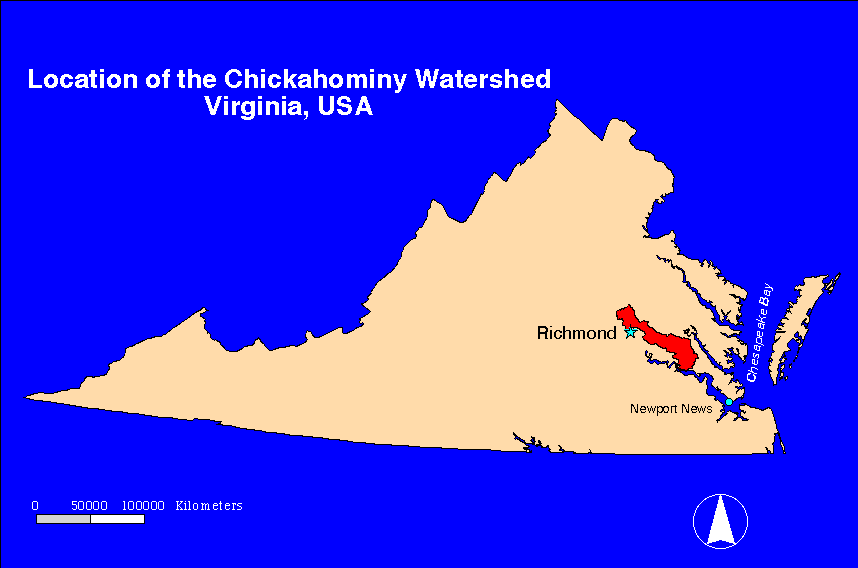