Geography education based on exploring real-world issues is well-suited to make a significant contribution to our students, communities, and world. The use of geographic information systems (GIS) technology and methods has tremendous potential to incorporate issues-based and inquiry-based education, and to increase the relevancy and utility of the disciplines in which they are used. Geographic information systems make the process of presenting and analyzing geographic information easier, so they accelerate geographic inquiry" stated the participants of the Geography Education Standards Project (1994: 45). An increasing number of educators consider GIS to be one of the most promising means for implementing educational reform, by using teams of students who construct their own analyses and geographic representations of real-world data.
Empirical evidence is critically needed that indicates whether GIS tools are simply another promised technical solution to education whose rewards may never materialize, or whether GIS can enhance the acquisition of geographic skills and knowledge. Research is needed to move the educational community to an understanding of whether GIS tools can lead to a more effective use of spatial technology to enhance critical thinking skills. What are the educational settings and learning styles where GIS can be effective? A rigorous, qualitative and quantitative assessment of these lesson modules is necessary to understand the effect of the technologies on the knowledge of geographic content of selected secondary school geography students. How can evidence be generated that would lead to a more effective use of GIS technology to teach geography?
In order to address these concerns, this research seeks to assess the effects of inquiry-based lesson modules that use GIS technology on teaching and on the acquisition of standards-based geographic content and skills. Unless an examination of how lesson modules based on these technologies can be developed and tested, progress toward true assessment of GIS cannot be made. Educators also need practical, usable research results. Research needs to include the practical component of developing modules that teachers can test in their own classrooms. Teachers will be able to use the evidence and lesson modules developed through this research to understand the potential of GIS tools to begin transforming geography teaching and learning.
This research postulates four hypotheses:
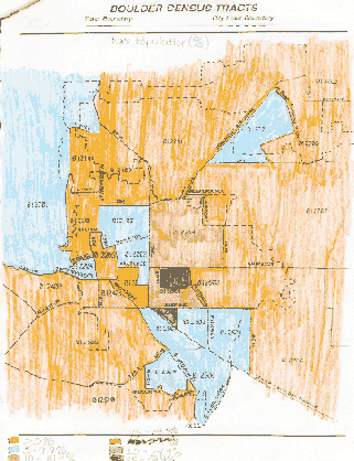
During the summer of 1996, Boulder High School purchased Esri's ArcView K-12 Schools and Libraries package. GIS-based lessons began with an Advanced Geography unit called "The Hill Neighborhood Analysis" during the 1996-1997 academic year. This unit, through Spring 1999, has now been conducted for three academic years. In this unit, students examine 1990 census housing and demographic data to compare "The Hill" neighborhood in Boulder to other neighborhoods in the community. A 1972 article in the Journal of Geography identified The Hill neighborhood in Boulder as an urban ghetto (Mason 1972). Lack of spatial mobility, crowded conditions, and low income were among the variables cited as evidence for the claim that the area was a ghetto. This is unexpected reading, particularly in an affluent community such as Boulder, and one that all students from the high school had familiarity. This lesson is online at http:///bvsd.k12.co.us/schools/BHS/departments/socialstudies/hill/hill.html.
Students are asked to analyze four demographic characteristics and discuss whether the author's claims were true in 1972, and whether they are true today. After an introductory lesson on the definition and applications of GIS, the students are then asked to select and map 12 to 16 variables to support their position. This unit was expanded during the 1998-1999 year to include a temporal component - - students compared historical demographic data from the 1970 census and 1980 census to that from the 1990 census.
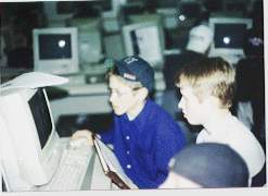
During the 1997-1998 academic year, GIS was introduced into the Geography 1 course for Grade 9 students with a regional geography unit on Africa. This unit was expanded in its second year. The Africa regional geography lesson, online at: http://bvsd.k12.co.us/schools/BHS/departments/socialstudies/africa/afrmeta.html, is comprised of seven modules. It was originally selected because a pretest had revealed that students had demonstrated less knowledge about Africa than any other continent. ArcView-based module topics included surface features and physical characteristics, population and cultural characteristics, human and natural resources, and natural hazards.
Each Africa module requires from one to two days of computer lab time. The first module occurs after a three-day lab session in which students work through the ArcView Quick Start tutorial. Students in each module construct maps from the database provided, and use these to answer a series of questions.
The 1998-1999 year marked the implementation of a new unit called "Earthquakes
Everyday," where students analyze the spatial pattern of earthquake data
from the past five days, comparing it to plate boundaries, fault lines,
cities, and GNP. This earthquake unit was given to the Geography
1 classes. It is online at:
http://bvsd.k12.co.us/schools/BHS/departments/socialstudies/earthquake/earthquake.html.
A summary of experiments conducted is as follows:
|
|
|
|
|
|
|
|
|
|
|
|
|
|
|
|
|
|
|
|
In experiment 1, two classes were taught using the class textbook, a preprinted list of earthquake locations, and the class atlases. Students plotted the latitude and longitude locations of recent earthquakes using pencils and a printed map, and use the atlases for the additional data such as plate boundaries and cities. The other two classes were taught the same earthquake lesson using the Internet and GIS. ArcView GIS plotted the earthquake locations as an event theme. The list of questions were identical between the two groups.
In experiment 2, two classes were taught using only a textbook and atlases, while two other classes were taught the same Africa lesson using GIS. Again, the list of questions were identical.
The control group was comprised of class Periods 1 and 3, while the experimental group was class Periods 5 and 7 for both the earthquake and Africa units. The "Non-GIS" classes (control group) did not use GIS at any time during the entire semester for these or any other units.
In experiment 3, one class was taught "The Hill" unit with GIS. The results for this class, with those from GIS-based classes from 1997 and 1998, were compared with the results for the same unit completed by 1994, 1995, and 1996 Advanced Geography classes. These 1994-1996 classes represented the control group that did not use GIS.
Non-GIS students used the same textbook and atlases that they used in other class activities. Therefore, much more than the GIS students, they were familiar with the learning tools.
Each group was given two types of pre-tests and post-tests. The first type was comprised of selected multiple-choice questions from a test from the National Council for Geographic Education (NCGE). These questions (53 for Grade 9 and 75 for Grades 11-12) were selected by the teacher for two reasons. First, they were the ones that most closely aligned with the Boulder Valley School District's K-8 curriculum, and therefore, they would cover topics that students were most familiar with. Second, the questions were selected that were "timeless" in the sense that they did not refer to a place that had changed names or otherwise give an indication that the test was over 10 years old. Questions on both physical and human geography were included.
The mean score on the NCGE pre-tests showed that there was no significant difference at the beginning of the semester between the classes scheduled for GIS and those scheduled for traditional methods. Out of a total of 53 questions, the average correct was 33.81 (63.8%) and 34.4 (64.9%) for the two non-GIS classes, and 32.6 (61.5%) and 30.8 (58.2%) for the GIS students. Therefore, no significant difference between the control and the experimental groups existed before the start of the experiment.
The second test was a 15-minute spatial analysis exercise that required students to rank factors that were important in siting a new location for a hypothetical restaurant named "Spiffy's." Students analyzed five maps of an urban area showing major and minor streets, existing Spiffy's Restaurants, locations of high schools, percent of population aged 15-24, median household income, and zoning. Students were required to plot three points for the locations of their top three choices for the restaurant, and to rank the variables in order of importance from one (most important) to six. Finally, they were required to write a narrative explaining how they chose their top three locations for Spiffy's. In contrast to the NCGE test, Spiffy's had no single correct answer, although some locations could clearly be in error. Examples of locational errors in locating the restaurant include the middle of a freeway interchange or an area zoned as residential.
 To assess the difference that GIS made in the curriculum, a comparison
was made between the NCGE pre-test versus post-test results, between the
Spiffy's Spatial Analysis pre-test versus post-test results, by comparing
the papers turned in by the control and the experimental groups, and by
a case study of each of the groups.
To assess the difference that GIS made in the curriculum, a comparison
was made between the NCGE pre-test versus post-test results, between the
Spiffy's Spatial Analysis pre-test versus post-test results, by comparing
the papers turned in by the control and the experimental groups, and by
a case study of each of the groups.
NCGE Pre-tests versus Post-tests
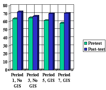 Post-test scores for the NCGE test for the non-GIS students increased by
a mean of 8.5% and 2%, respectively, for each class. Scores for GIS
students increased by 8.5% and 12.5%, respectively. Thus, the GIS
students exhibited a significantly greater amount of improvement over the
non-GIS students.
Post-test scores for the NCGE test for the non-GIS students increased by
a mean of 8.5% and 2%, respectively, for each class. Scores for GIS
students increased by 8.5% and 12.5%, respectively. Thus, the GIS
students exhibited a significantly greater amount of improvement over the
non-GIS students.
Spiffy's Pre-Tests versus Post-Tests
A scoring guide was created to assess the Spiffy's Spatial Analysis tests,
shown in the table below. Points in each box indicate the total possible
for that element. The maximum score was a 15.
|
|
|
|
|
|
|
|
|
|
|
|
|
|
|
|
|
|
|
|
|
|
|
|
|
|
|
|
|
|
|
|
|
|
|
Tests for those who were the highest and lowest three students in the class were assessed. These students were identified after their entire semester's work had been completed and assessed. Thus, they represent the top three and bottom three students in demonstrated and assessed skills in each class.
The average pre-test score for all Grade 9 classes was 9.8 and the average post-test score was 10.9. Scores for Period 3, one of the non-GIS groups, was not included, because the students did not have an adequate time to record the explanations for the locations they chose in the post-test. The control group's average pre-test score was 9.2, which rose by 2.5 points to 11.7 for the post-test. The experimental group's average pre-test score was 10.1, which rose by 0.4 points to 10.5 for the post-test. Thus, students who used GIS during the semester did not demonstrate a higher score or a higher level of improvement as demonstrated by their ability to consider factors in locating a fast-food restaurant.
However, a comparison of the students by demonstrated skill level showed that GIS may benefit students with lower skills more than those with higher skills. Scores of the lowest-skilled students using GIS increased by 1.7 points over the semester, versus a decline of 0.2 points for the highest-skilled students. While the same trend was noted in the control group, this suggests that the use of GIS should not be confined to classes of highly gifted students. Indeed, it was noted in classroom observation that many students of low-to-average skill levels became enthusiastic about geography only after the introduction of GIS. During the Fall semester 1998, special education students at Boulder High School became quite proficient at GIS, citing its graphics and step-by-step methodology as the reasons for their enthusiasm.
Earthquake and Africa Experiments
For the earthquakes unit, the non-GIS modules required one to two days
to complete. Equivalent GIS-based modules required two to three days
to complete. In all units, students using traditional tools
finished each module faster than the students using GIS. However,
"faster" is not necessarily "better." Non-GIS students learned the
content, but GIS students learned new skills in addition to the content.
Furthermore, the additional time required for GIS-based lessons presents
a challenge for teachers confronted with the challenge of teaching "depth"
versus "breadth."
 GIS
groups spent three days completing the ArcView tutorial. The tutorials
were used so the students could establish familiarity with the program
and develop a comfort level. They learned simple skills, but they
did not learn all skills required for the modules. Therefore, they
encountered new problems during the modules that required them to construct
their own solutions.
GIS
groups spent three days completing the ArcView tutorial. The tutorials
were used so the students could establish familiarity with the program
and develop a comfort level. They learned simple skills, but they
did not learn all skills required for the modules. Therefore, they
encountered new problems during the modules that required them to construct
their own solutions.
In the earthquakes unit, control group students spent an entire class period plotting locations of epicenters by latitude and longitude coordinates on a paper map. Experimental group students also had a labor-intensive task to perform, that of editing the earthquake data from the Internet. These data had to be formatted into a comma-delimited text file that ArcView could use. This may appear to be a substitution of one monotonous task for another. However, the students using GIS were learning important skills. First, they learned how to change data from one format to another. Second, they learned how to use data from the Internet to create new data, and to analyze their new data in a separate application. They could begin to imagine other spatially-referenced data on the Internet and in textbooks that they could analyze in the context of a GIS. However, the danger in the GIS-based method was for the students to overlook errors in their editing of the table that could lead to plotting in the wrong location. A tendency for the computerized map to be viewed as "perfect", even when it might not be, was noted.
Because of the process of making maps in GIS required students to view information with greater frequency, such as boundary locations, students did a better job in putting the shapes and names of Africa countries together as well as the relative locations of countries. This refutes the notion that GIS does not teach students traditional locational content knowledge.
"The Hill Neighborhood Analysis" Experiment
The "Hill neighborhood analysis" required seven days of laboratory time, including two days to complete a majority of the ArcView tutorial. This compares to five days required without GIS. However, the GIS-based version represented an expanded lesson over the traditional lesson. During the Spring semester 1999, GIS-based students were permitted to spend more than seven days on the project. One reason was that the chronological component had been added.
It took longer during 1999 than 1998 for students to become comfortable with the technology. Classes normally vary in these characteristics from year to year. However, the 1999 students made better judgments about the combinations of attributes to display on the same layout.
GIS-based maps in layout form took time to create, just as preparing choropleth maps by hand did in the past. Students were given a limit on how many maps they could make - - between 12 and 16 maps. This upper limit caused students to think and plan. However, the lower limit allowed students to have some creativity in which to choose the variables they were to map. Because more variables could be mapped faster and more completely, the depth and thought behind answers improved.
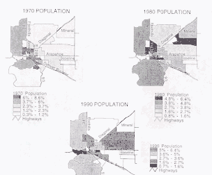
The first example below is one hand-drawn map of Boulder Census Tracts before GIS implementation. The next example shows a student's layout that included three views from the 1970, 1980, and 1990 census.
When the students first started the unit, they could only create one view in a class period. After three days, the students could compile multiple views and create multiple layouts per class period. The process of mapmaking with GIS caused the students to look more carefully at their selections of attributes they chose.
Until they became comfortable with the process, they considered their choices more carefully to avoid having to make more maps than were needed. By the time they became comfortable with the mapmaking process, students had spent quite a bit of time thinking about attributes so that as they progressed, the level of concentration on the maps increased. The quality of the maps increased as well.
GIS students demonstrated a better integration between the process of making the maps and the process of analyzing the maps. The GIS process encouraged more thinking about how attributes connected to answering the questions. The limit on the number of maps required some thought about what was needed, yet still allowed room for "creative selections." Discussions with the students revealed that they were thinking ahead while making maps as to how they would answer the questions. There was processing on a deeper level of the information at an earlier stage of the project with the use of GIS, than the non-GIS students
The students who scored higher incorporated two levels of analysis.
First, they decided which attributes fit with which part of the model.
Second, they had to decide which attributes were related, and which attributes
and the corresponding view should logically be plotted together on the
same layout.
Project maps improved in several ways as the days progressed.
The mechanics of the layouts improved.
The spacing and sizing of the maps improved. There were better legend
components and color selections. Most significantly, more concern
was given to pairing maps in the layouts containing data with logical comparative
attributes in the layouts. For example, students compared median
income with age, rather than unrelated items. Therefore,
while working through the modules, the skills and analysis required became
progressively more advanced. In this way, both the skills
in using GIS and the thinking process are
pushed to higher levels.
Students did not want to waste time creating maps that they did not need. Therefore, students behaved like managers of a data project, and developed an essential workplace skill.
.
GIS also allowed for an easier expansion and revision of a project.
Revision is an important factor when striving for sustainable projects
- - those that can be re-created and re-used. Sustainable projects
are important when using GIS because of the large "up-front" time commitment
required to gather and load data, create lessons, test computer-based instructions,
and configure computer systems.
GIS-based students continue to produce work of higher quality across all grades and units than non-GIS students. According to the teacher, C-grade papers using GIS are better than C-grade papers by the non-GIS students. This implies that the teacher's expectations for the project have increased: Because it is easier for students to produce maps, they are expected to spend more time in analytical thinking. Therefore, with a lesson that has a limited time frame, students are able to discover a greater number of relationships between attributes. Understanding these additional relationships leads to a better understanding of how physical systems and human systems are connected (Africa and Earthquake lessons) and how demographic and housing characteristics are related (Hill lesson).
GIS not only changed the number and type of maps that the students prepared - - it altered teaching and learning of the entire project. Due to the use of hand-colored maps, the number of variables that could be mapped and analyzed was limited. When the Hill project was done manually, students were not anxious to analyze 12-16 variables, since analyzing four or five required an entire week to do. The problem was solved by introducing GIS into the project. GIS increased the amount and expanded the types of data available to students. Rather than giving the students four variables, over 60 variables were provided, and it was now up to the students to decide which ones supported their position. If a variable did not exist, the students were able to calculate it using ArcView's table calculation function. The paper-and-pencil maps were replaced by ArcView layouts, which allowed for faster map production, permitting time for analysis without extending the project time.
Therefore, GIS led to a much better project than was envisioned when it was first created. Neither the temporal component nor the analysis of 60 variables from the 1990 census were possible before the advent of GIS. The projects were strengthened with GIS, because more data was readily available to do analysis with. With GIS, students could review a larger data set, and be able to make a better decision about which variables to choose to prove their point.
Because students selected their own variables, they had much more ownership of the project with the GIS component added. There was a marked increase in the frequency of referring to the maps as analytical tools after GIS was added. Before GIS, students viewed the construction of maps and the writing of the essay as two distinctly separate activities. Referring to the maps in the analysis is significant, as it indicates progress in spatial reasoning. Most students reacted favorably to GIS, even those who claimed a dislike to computers.
The
process of GIS itself fosters more analytical thinking, because it comes
across in a more scholarly, formal way.
It is more sophisticated approach. It causes students to reflect
more about what they are doing.
With GIS-based lessons, the need to follow directions precisely was found
to be critical. No shortcuts are possible to achieve the desired
results. The students were repeatedly told, "Do what the directions
say, not what you think they say." Students must listen to the instructor
and read the computer procedures carefully. Most of the student's
questions arose because they had not read the directions.
Most students were familiar enough with computers to know that computers
do not always work the way they are supposed to. With only a few
exceptions, the students were generally patient. Many students attempted
to solve problems that were not part of the original lesson by themselves,
using the teacher as a "last resort." Surprisingly, even though Spring
1999 marked the end of the third year of GIS at the school, technological
problems still arose. The bulk of these problems involved transferring
and using files on the network. Only occasionally when there were
system-wide errors did the process interfere with learning. Even
then, a method was found to work around the problem was usually found,
sometimes by the students themselves.
The second hypothesis was also supported: Instructional methods that are required when teaching with GIS are more closely aligned with the key tenets of modern educational reform than traditional, non-GIS methods. Certainly, teachers can use these methods without GIS, but GIS "forces" a class to deal with lessons with unknown results. GIS requires reformist methods such as posing real-world questions in a problem-solving, team-based, inquiry-based, open-ended environment, where the teacher is a facilitator of knowledge, rather than a dispenser of it. GIS is more than a technology, it is a method of instruction.
However, it must be pointed out that the evidence at Boulder High School indicates that teachers who use GIS might not be changing their original teaching style. This is because they already used reformist teaching methods before the introduction of GIS into their curricula. This indicates that teachers who are willing to adopt GIS are already pre-disposed to methods that offer teaching in a new way, with uncertain results, including real-world data and problem-solving techniques. At Boulder High School, several units were fairly well structured, particularly the Africa units. A teacher that relies primarily on traditional, structured lessons could use GIS in this way with his or her customary teaching style. However, this research indicates that these teachers might not be attracted to using GIS in the first place.
The third hypothesis - - that the introduction of GIS-based lessons and methods will increase the geographic skills as measured by national geography standards of selected secondary-school geography students to a greater extent than do the same modules that do not include GIS - - was supported by the results of the NCGE test. It was not supported by the Spiffy's spatial analysis test. However, the Spiffy's test indicated that students with low-to-average geographic skills have the potential to benefit even more by GIS than those with the highest skills.
The fourth hypothesis, that the use of GIS strengthens inquiry-based, standards-based skills, rather than traditional locational geographic knowledge, was supported only in part. GIS does strengthen standards-based skills and encourage spatial analysis. Students ask geographic questions, and acquire and organize the information necessary to analyze and answer geographic phenomena. However, locational geographic knowledge was also increased, as the NCGE tests showed and classroom observation supported. For example, by becoming immersed in the GIS lesson on Africa, students were able to identify and locate features of the cultural and physical environment to a greater degree than before they began the unit. One reason is likely due to the fact that students are immersed in GIS-based lessons for a longer time than the same lessons that do not use GIS. More "time on task" enabled the students to have a better understanding of absolute and relative location as a result. Another reason might be that the students pay more attention to an image on a computer screen than an image on a paper map in an atlas or textbook.
It was assumed that geographic skills of secondary students as measured by the national geography standards can be accurately assessed by the administration of a series of pre-tests and post-tests. The implementation of these tests in this experiment did not indicate anything otherwise. Although the Spiffy's test was an attempt to assess the students' spatial analysis skills, it must be recognized that it is extremely difficult to measure spatial reasoning, cognition, and analysis.
Research on the incorporation and assessment of GIS in the curriculum is still in its infancy. It is hoped that this study will encourage others to pursue avenues of research and development to take advantage of this technology and method to improve the quality of education. The quality of education in Boulder High School's geography program has been enhanced with the incorporation of GIS. GIS fits in well with the school district's goals of increasing the use of technology, higher-order thinking skills, and subject-matter synthesis across the curriculum. Additional research will be conducted by the authors to ensure that this quality is sustained over the long-term future in Boulder High School, and that it is considered in schools across the country.
Geography Education Standards Project. 1994. Geography for Life: National Geography Standards. Washington: National Geographic Society Research and Exploration, 272 p.
Mason, Peter F. 1972. Some characteristics of a Youth Ghetto in Boulder, Colorado. Journal of Geography, National Council for Geographic Education. 71(9): 526-540.
National Council for Geographic Education. 1986. Competency-based Geography Test, Secondary Level, Form 1. Indiana, PA: National Council for Geographic Education.
303-442-2430
Voice
303-447-5317
Fax
Doctoral Student
Department of Geography
University of Colorado
Campus Box 260
Boulder CO 80309-0260 USA
http://ucsu.colorado.edu/~kerski
joseph.kerski@colorado.edu
303-202-4315 Voice
303-202-4137 Fax