
John C. Shovic, Ph.D.,
April A. Caldwell
Electrical Engineering and Computer Science
Washington State University
Pullman, WA 99164-2752
509-335-2126, FAX 509-335-3818
jshovic@eecs.wsu.edu, http://www.eecs.wsu.edu/~jshovic
Henry F. Shovic, Ph.D.
Gallatin N. F.
Box 130
Bozeman, MT 59715, USA
406-587-6714, FAX 406-587-6758
hshovic/r1,gallatin (Forest Service)
hshovic@wtp.net (INTERNET)
INTRODUCTION
Next decade may very well be the "the Decade of the Sensor". The proliferation of inexpensive sensors for climate, environment and position and the wide availability of remote sensing data from satellites is starting to dramatically change the way data is gathered and displayed. Because of the high computational nature of many GIS tasks, special thought is needed to integrate real-time data into GIS based visualization and analysis systems.This paper focuses on the computational constraints and the dataflow of real-time data in such a system. A prototype system has been constructed utilizing Esri Map Objects in C++ .
RESEARCH LONG RANGE OBJECTIVES
To study and develop software methods and objects for incorporating real time remote sensing data from a variety of sources into Geographic Information Systems (GIS) for improving command and control response time and effectiveness. To develop methodologies and software structures to facilitate the adding of real time sensor data into geo-referenced software systems.
RESEARCH SPECIFIC GOALS
To (1) examine and categorize forms of available real time sensor data into various types and data uses, (2) derive methods and models for incorporating appropriate data into GIS systems, (3) do systems engineering, analysis modeling, and the object oriented design of the proposed database oriented GIS system and (4) develop a prototype Real Time Sensor Based GIS (RTSB-GIS) system for proof of concept and methodology verification.
TECHNICAL BACKGROUND
Currently, our ability to collect intelligence and sensor data has outstripped the ability to disseminate and utilize it. One possible solution for part of this problem is to incorporate the incoming real time sensor data into a data stream that can be handled by existing GIS systems. An object oriented approach to this problem is proposed to allow high levels of software re-use when changing sensor types or data evaluation and interpretation modules. This data can then be distributed via real-time links to provide tactical commanders with a common tactical picture. These real-time links may also allow mission planning while the mission is in progress.
SOFTWARE ARCHITECTURE
The software being developed is called the Spatial Analysis System (SAS). SAS is the integration of a specialized GIS system with the following main features:
A screen shot of the main program is given below:
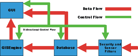
The overall program architecture is shown below:
The Graphics User Interface (GUI) main features are:
From a system perspective, SAS has significant issues with processor loading. As the system is designed to be moved to a severe resource limited environment (i.e. a palmtop computer), substantial attention needs to be paid to processor loading and thread contention. SAS is built with three threads running simultaneously as shown below:

These threads are dynamically balanced by the program depending on loading based on processor workloads, user commands and by sensor commands.
FUTURE DIRECTIONS
The SAS program is being moved to Windows CE 3.0+ in an attempt to move the system to a smaller form factor computer. The GIS portion of this program will need to be rewritten in order to use less resources.
CONCLUSION
SAS type applications are becoming possible to implement on desktop and on palm top computers. One of the major difficulties with this process is load balancing and resource allocation. Displays and storage space are becoming a significantly smaller problem. As internet (or network) aware applications become more common, there will be a strong drive to move GIS applications to smaller form factor computers. The ability of a properly designed object oriented design to be self modifying allows many new applications.
ABOUT THE PRIMARY AUTHOR
Dr. John Shovic has been involved in
technology and software for twenty five years. He has been active in software
and hardware design for most of that time. Dr. Shovic is a founder of two
companies, Advanced Hardware Architectures, a semiconductor company and
TriGeo, Inc., an Idaho based GIS company. He currently is on the Computer
Engineering Faculty at Washington State University and directs a new laboratory
for Computational GIS located in the Electrical Engineering/Computer Science
department.