John Woodcock, Israel Tauber, Michael Denesiuk
A small organization with a limited budget is restricted in its capacity to absorb new technologies. Existing employees must carry the burdens of project management, standards establishment, database administration, and field checking of new data, in addition to their ordinary functions. End users must often learn "in-service" rather than by formal courses. The ability to adjust standards and procedures on the fly is all-important. Success can depend on the capacity of the site expert. Much initial application development is driven by user needs. Examples are given from our Forest Department's GIS project, begun in 1995.
Introduction:
The operational word in this paper's title is "small". It is our belief than an organization's size is one of its most significant characteristics in the acquisition of new technologies like GIS. Size influences both the rate at which new technologies can be absorbed and the strategies that an organization must adopt if the technology is to be integrated successfully. There are many questions that touch on this issue. What are the characteristics of a small organization, which impede the implementation of GIS? To what aspects of this technology do small organizations find it difficult to adapt? What is the impact of the introduction of GIS on a small organization? How can such an organization solve successfully the issue of integration, within budgetary and manpower constraints?
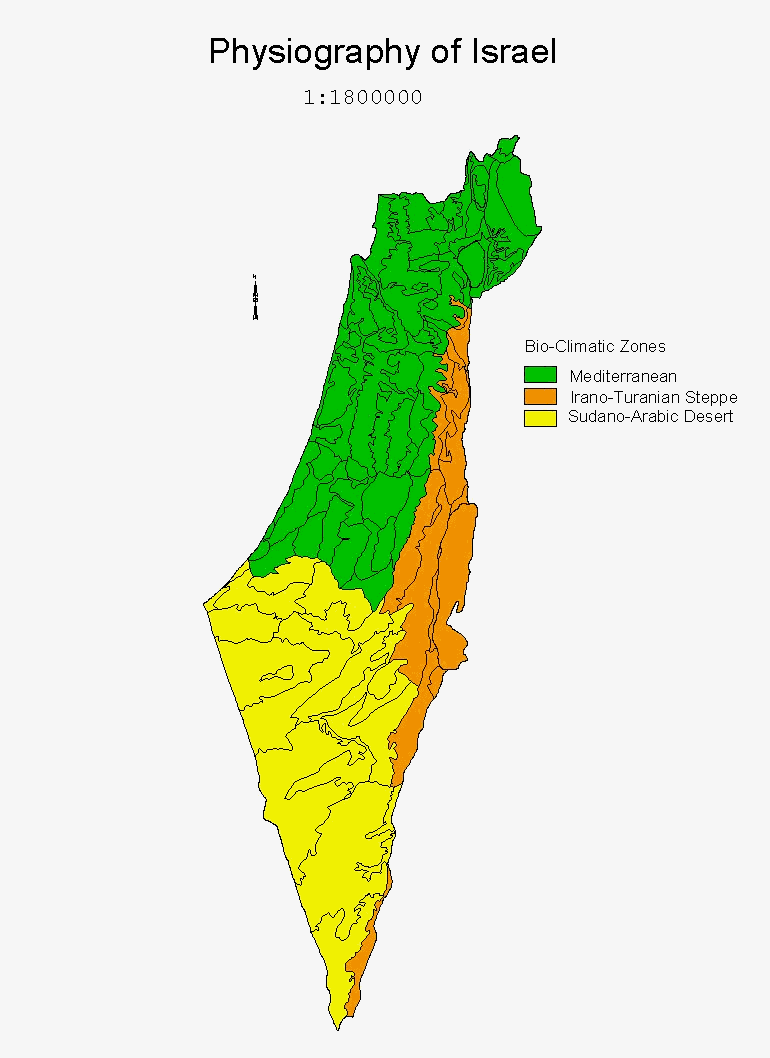
The meaning of "small" is, of course, relative. It is important to be specific here and note that the process being discussed is taking place within an organization with responsibility for forests on a national level. Such organizations, no matter the size of the country, are likely to have similar list of responsibilities, though in countries of highly varied physiography, like Israel, this list may be longer due to the variety of forestry activities (Fig. 1 Israel Physiography). Given a limited budget and manpower, this means that workers in a small national forestry organization will tend to have a broader range of responsibilities. A particular topic may only be one of the tasks of a single worker in the forest department of a small country, while in a much larger country a team of workers may be devoted to it. This situation affects significantly the way in which a new technology like GIS is approached, as we shall see below.
We want to make clear at the outset that what is reported below are not the results of research, but rather reflections on a process that we have observed over the past five years. Thus, we will not attempt to reach any general conclusions, and concentrate instead on noting specific "lessons" or "rules of thumb" which have aided the process of GIS integration in Israel's Forest Dept. Whenever possible we will illustrate the matter at hand with examples from our GIS project. We also wish to mention our indebtedness to the USDA Forest Service. Through consultation, professional exchange and contact in the early stages of our implementation, the sound advice of Mr. Ray Johnston of the Forest Service Southern Region and others got us off on the right track. Much of our understanding of this process is built on the sound base they gave us.
Who will implement GIS?
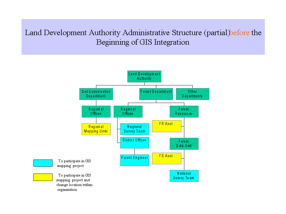
One of the first issues facing managers in an organization which has decided to begin integrating this technology is what mix of contract and in-house labor to use in GIS implementation. This is a complex issue and we raise it only in order to make a basic point. The management of information in any organization with professional responsibilities depends on its employees' capacities in two areas: the data management area and the professional area (in this case forestry). This means that the pivotal people in GIS implementation must have a good professional background as well as knowledge of data management. For a country like Israel, with a single organization dealing with forestry (there are no private forests here), we thus had to find within the Forest Dept. professional people with the capacity to lead the process of GIS implementation (Fig. 2 Administrative Structure Before).
To continue our story, we must now change emphasis and provide a framework within which the process under consideration may be clearly seen.
The Mapping Project
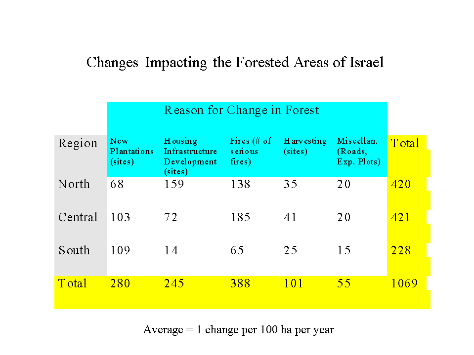
It is both natural and proper that any introduction of new technology be driven by need. In our case, the clear and pressing need was for up-to-date maps for use by our foresters and managers. Over the past two decades Israel's forests have come under increasing pressure from a growing population. In addition, there has been a severe decline of one of our main forest species due to a pest outbreak. Forest maps became out of date due to the inability of the traditional updating process to keep pace with this increasing rate of change in our forested areas (Fig. 3 Change Table). This led to a situation in which existing maps lost much of their utility.
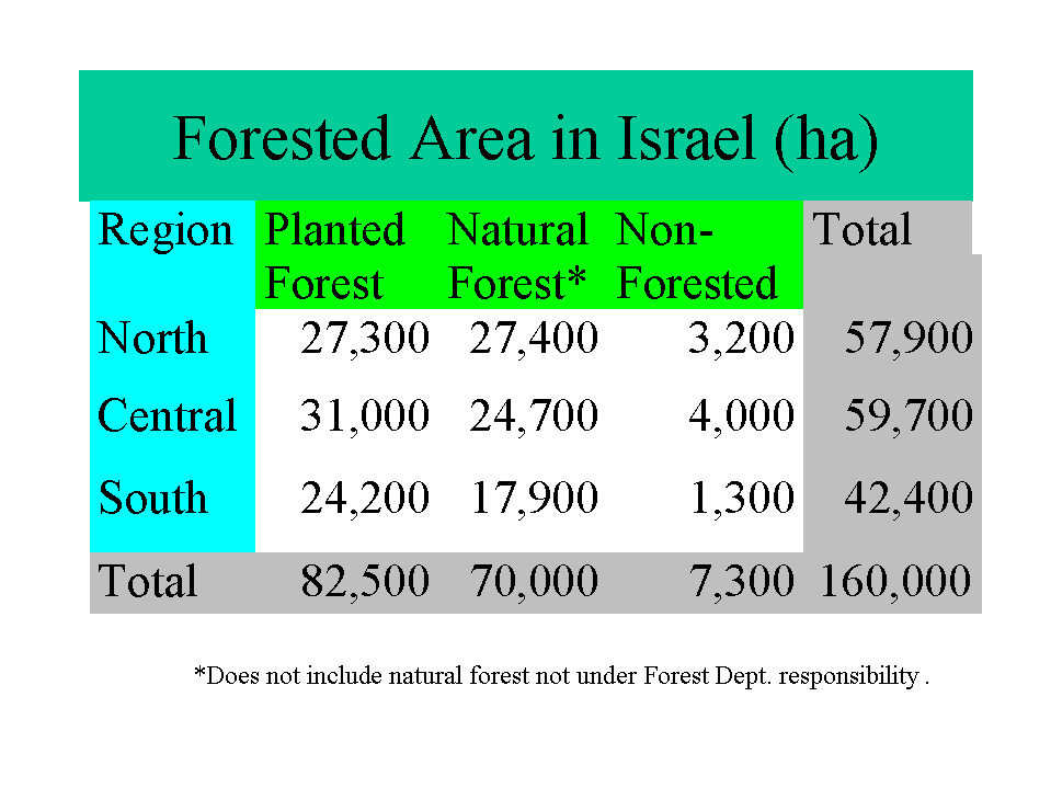
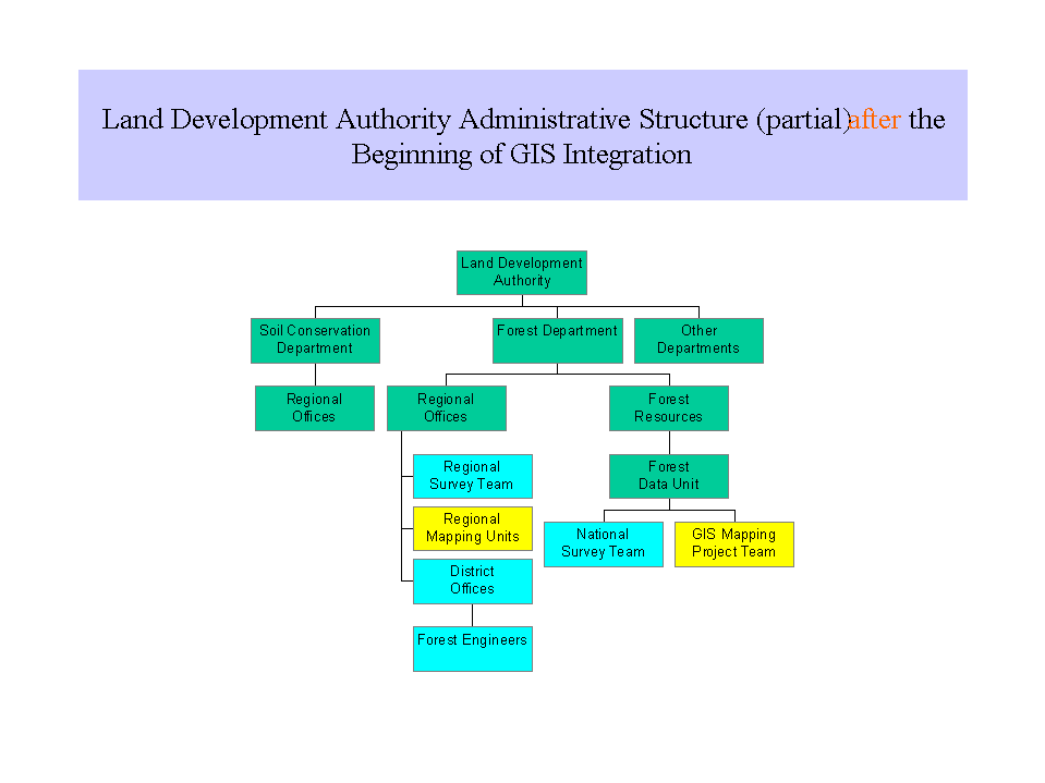
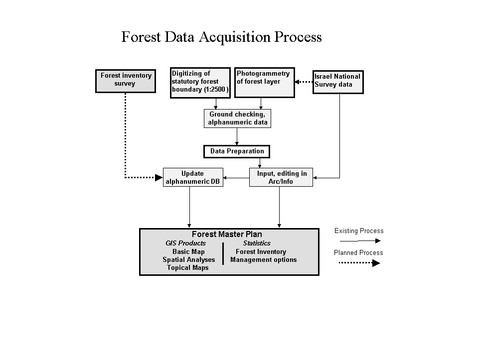
Thus the focus of the introduction of GIS into the Forest Dept. became a project to re-map all of Israel's forested areas (Fig. 4 Forest Area Table). The team chosen to carry out this project was made up of, for the most part, existing department employees with contracted support for the development of initial applications (Fig. 5 Administrative Structure After). A pilot study enabled the team to gain experience and aided managers in deciding what layers to include in the data base, in determining data standards, and in establishing standard procedures for data acquisition. In January 1996, the mapping project began in earnest (Fig. 6 Project Flow Diagram).
Cooperating on Standards
An early decision was to adopt the mapping standards of the National Survey of Israel, which was already engaged in a national GIS mapping project. The standards adopted related both to the accuracy (1:5000, 2-meter) and basic coding of base map features during photogrammetric analysis. For small organizations, we highly recommend this approach of "building on the work of others", despite some limitations. It speeds up some of the initial stages of the project and facilitates the data sharing between organizations. In fact, when the forest mapping project is complete, a generalization of our data will be used by the National Survey for forested regions. This is due to the high accuracy that results from our intensive field checking.
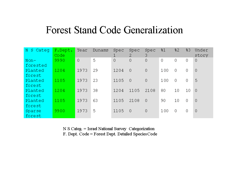
Cooperation between the mapping projects of different organizations does require a greater effort at coordination. An absolute requirement is that data acquisition and updating of each layer be the responsibility of a single organization. In principle, this is not so hard since, for example, the Forest Dept. has special interest and expertise in forested areas and thus can take national responsibility for this layer. It can also carry out more detailed mapping of forested areas for professional purposes, as long as these can be generalized into the agreed standard categorization (Fig. 7 Forest Codes).
Coordination can be more difficult since the order of priorities of an organization, as dictated by its objectives, affects the mapping process. A case in point is our road layer. In principle, this layer is under the responsibility of the National Survey, with the Forest Dept. using a generalization, since our forest maps don't need to show all the categories of highway needed on a public road map. This neat arrangement comes apart because of differences in order of priorities in two areas:
![]() Which areas of the country should be mapped first? The Forest Dept. has a natural tendency to give priority to more forested areas of the country, whereas the National Survey's priorities derive from other needs. Since both mapping projects are being carried out over the same period, and since forest roads are in fact the "" of the (planting sites are normally bordered by roads), the Forest Dept. realized that it must map both forest roads and those leading into the forest. The central objective here is to provide useful data as quickly as possible to users, who won't have to wait for crucial layers from an outside agency.
Which areas of the country should be mapped first? The Forest Dept. has a natural tendency to give priority to more forested areas of the country, whereas the National Survey's priorities derive from other needs. Since both mapping projects are being carried out over the same period, and since forest roads are in fact the "" of the (planting sites are normally bordered by roads), the Forest Dept. realized that it must map both forest roads and those leading into the forest. The central objective here is to provide useful data as quickly as possible to users, who won't have to wait for crucial layers from an outside agency.
![]() How important are forest roads? As can be concluded from the foregoing, the Forest Dept. gives high significance to the accuracy and completeness of the forest road layer. This is not only emphasized to our photogrammetry contractor, the data is also checked on the ground and supplemented by GPS survey in cases where forest canopy hides the roads. For Israel's National Survey, accurately and completely mapping forest roads has low priority and the Survey does very little ground checking. Thus, even in those areas mapped first by the Survey, we must re-map the forest roads.
How important are forest roads? As can be concluded from the foregoing, the Forest Dept. gives high significance to the accuracy and completeness of the forest road layer. This is not only emphasized to our photogrammetry contractor, the data is also checked on the ground and supplemented by GPS survey in cases where forest canopy hides the roads. For Israel's National Survey, accurately and completely mapping forest roads has low priority and the Survey does very little ground checking. Thus, even in those areas mapped first by the Survey, we must re-map the forest roads.
The case of the road layer is an exception, though an important one. Most of the other basic layers in our database are being bought from the National Survey including: topography (DTM), structures, non-forest open land, streams and water bodies, infrastructure, and various annotation layers. Other important data layers are being obtained from the appropriate organizations, such as soils from the Agricultural Ministry.
A Special Database
The unique characteristics of a Geographic Information System result in the need for data administration to be carried out by professionals (in forestry, in our case), as mentioned above. Since a GIS is often looked at as adding prestige to the unit responsible for it, this often results in a conflict between the professional unit charged with this task and the "computer systems department" which has traditionally had responsibility over data systems in the organization. We took seriously warnings from our U.S. Forest Service colleagues about the problems of being "held hostage by the experts", and this aided the decision to give the responsibility for GIS implementation to forestry professionals. We also continue to invest effort in explaining the special characteristics and needs of spatial databases to our systems administration. This conflict must be resolved, not only for reasons of overall harmony, but also because these two departments will have to work together on what can be a complex issue for a small, yet national, organization: database architecture.
The complexity of the issue of the architecture for a spatial database for our forests arises out of four factors:
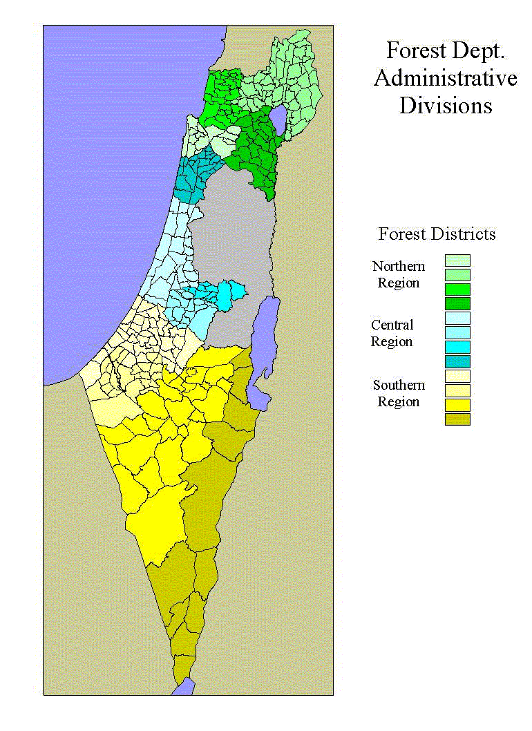
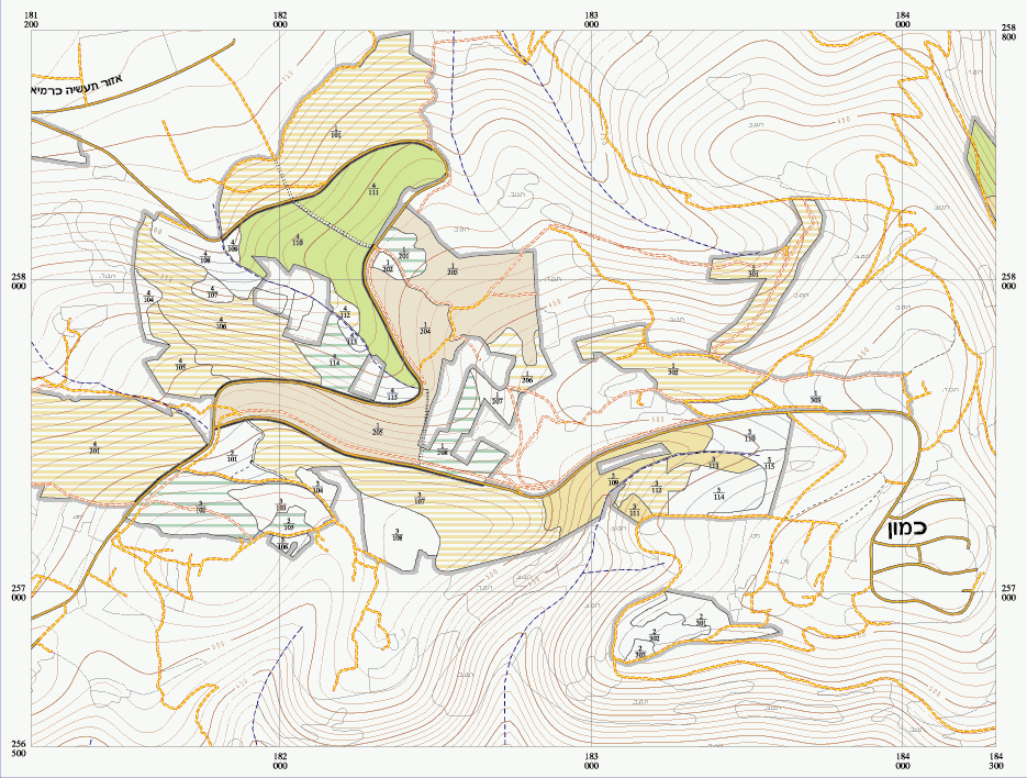
Our Forest Dept. is divided into three administrative regions (roughly parallel to National Forests in the U.S.), each of which is divided into three districts which have direct responsibility for forest management (Fig. 8 Region Map). As a compromise between the first two factors above, we decided early in the data acquisition process that database building and maintenance would be carried out by each region, whereas field checking and initiation of the updating process would be the responsibility of the districts. Our national forest database is thus split into three and located on regional servers. We thus must provide a mirror site for users in the national office (Fig. 9 Database Architecture).
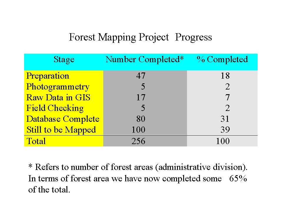
The database has been built by "forest area", administrative units dividing the whole country. At present, this division continues to be maintained in the directory structure of the database. Data acquisition should be complete within two years (Fig. 10 Progress Table). As a national organization managing "continuous" data, we must soon face the task of employing architecture and software, such as SDE, which will allow for the combination of such data into a single layer while allowing user access to a chosen "clip". It is in this task that our capacity for interdepartmental (GIS team and systems administration) cooperation will receive its critical test.
Users are the Key
Just as technological change must be driven by real need, the end-users, who supply that need, are the linchpin holding the GIS implementation together as well as the power to enable its progress. In the Forest Dept., this process was initially driven by the need for forest maps, which have been provided by a special AML application which is run as soon as the mapping process has been completed (Fig. 11 Forest Map Section). These maps are very popular and are in use at all levels of the department. Other needs have been slower to surface. Two factors have stood in the way:
![]() Acquisition of software has been extremely slow. Arc/Explorer freeware has been employed as much as possible, and Arc/View has recently begun to be used on the regional level.
Acquisition of software has been extremely slow. Arc/Explorer freeware has been employed as much as possible, and Arc/View has recently begun to be used on the regional level.
![]() Users are still relatively unaware of the potential of GIS to serve their needs. This is in part due to the first factor, but also derives from a lack of support for sufficient in-service training, which could be utilized as a framework for demonstrating, in detail, the sorts of product GIS tools can provide.
Users are still relatively unaware of the potential of GIS to serve their needs. This is in part due to the first factor, but also derives from a lack of support for sufficient in-service training, which could be utilized as a framework for demonstrating, in detail, the sorts of product GIS tools can provide.
Our low-budget, small-organization, adaptation to this situation has been to maintain a responsive interaction to users through whatever means are available and whenever a situation with potential arises. Three examples follow:
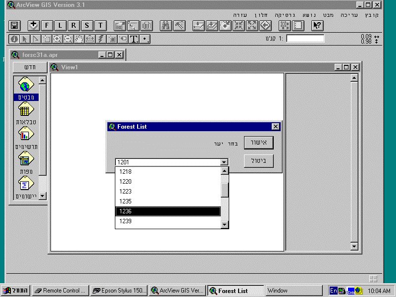
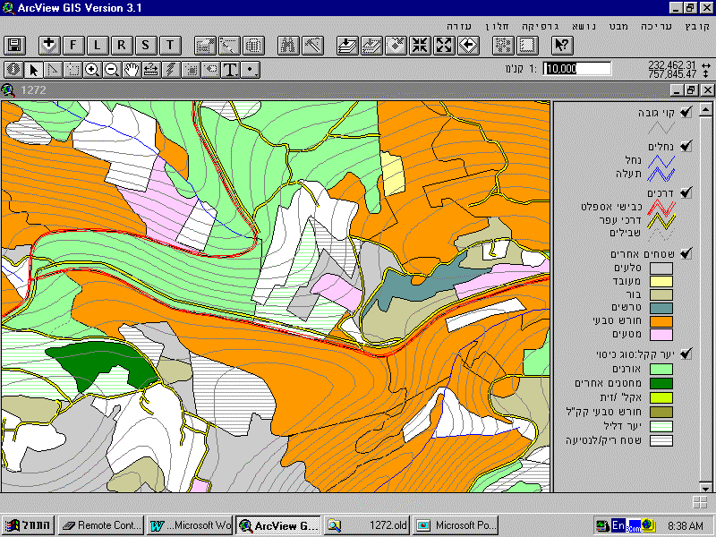
![]() Use of "framework" applications in Arc/View. We refer here to applications that allow easy access to data for users, but are simple enough to be produced quickly in-house (Fig.12 A/V Frame Application 1, Fig.13 A/V Frame Application 2). While not intended to produce a finished product for any pre-planned purpose, these applications provide a bridge for new users of A/V to get more immediate results at the same time as they are learning to utilize the extensive capacities of this software.
Use of "framework" applications in Arc/View. We refer here to applications that allow easy access to data for users, but are simple enough to be produced quickly in-house (Fig.12 A/V Frame Application 1, Fig.13 A/V Frame Application 2). While not intended to produce a finished product for any pre-planned purpose, these applications provide a bridge for new users of A/V to get more immediate results at the same time as they are learning to utilize the extensive capacities of this software.
![]() Sensitivity to potential user requests. A great deal can come out of informal contacts with users and potential users at various levels. Such possibilities are often not couched in the form of a request, but rather may be simply a description of work underway. The example given here (Fig. 14 Segev Forest) was the result of a casual conversation between one of us and his neighbor, a forester, about the difficulties of planning the harvesting forest stands affected by severe pest damage. The result may by "trivial" relative to software capabilities, but crucial in developing understanding among users.
Sensitivity to potential user requests. A great deal can come out of informal contacts with users and potential users at various levels. Such possibilities are often not couched in the form of a request, but rather may be simply a description of work underway. The example given here (Fig. 14 Segev Forest) was the result of a casual conversation between one of us and his neighbor, a forester, about the difficulties of planning the harvesting forest stands affected by severe pest damage. The result may by "trivial" relative to software capabilities, but crucial in developing understanding among users.
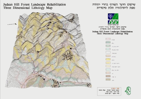
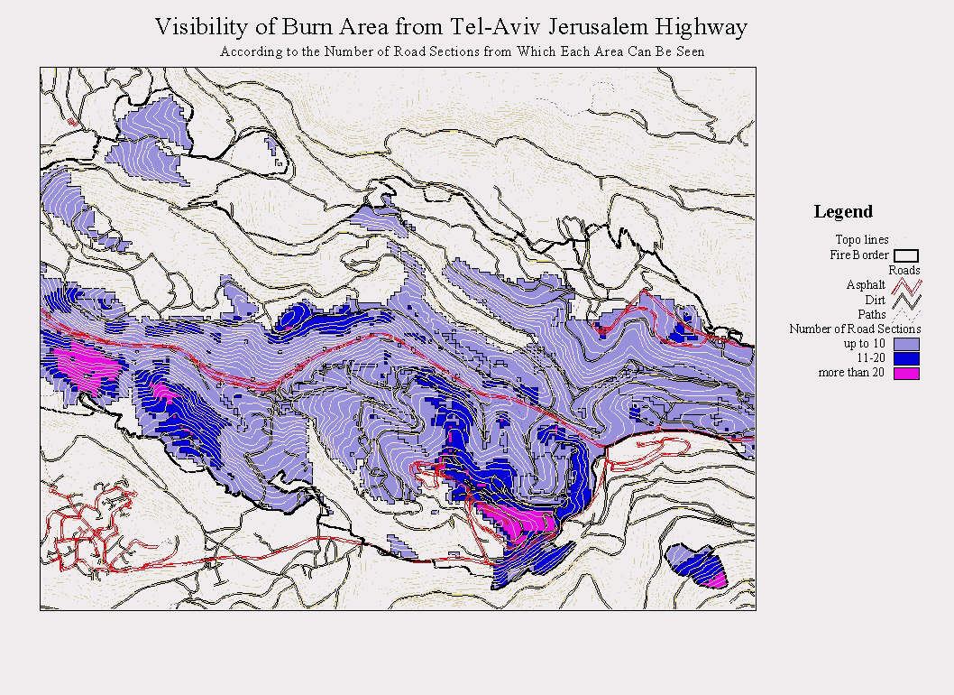
![]() Jumping on opportunities: We live at a time when forests are under pressure worldwide. Such "pressure" often takes the form of "disasters" (fire, pests), which can sometimes provide an opportunity to demonstrate the capacity of GIS to a wide audience. What is often required, however, is a very fast response. For a small organization, this may mean delaying the main project for a week or two and devoting all efforts to the crisis. An example from our experience concerned the largest forest fire since the founding of the Forest Dept. (ref. International Forest Fire News). The central location of the area burned (on the main Tel-Aviv Jerusalem highway), and its national historical importance led to a struggle for control over planning its rehabilitation. The Forest Department's ability to produce GIS maps of the area a week athe fire strengthened its posiregard tthe rehabilitation plan and provided a much more comprehensive basis for planning (Fig. 15 3D Map). Priority for carrying out management actions according to visibility rank from the highway provides a classic use of GIS analysis (Fig. 16 Visibility Analysis).
Jumping on opportunities: We live at a time when forests are under pressure worldwide. Such "pressure" often takes the form of "disasters" (fire, pests), which can sometimes provide an opportunity to demonstrate the capacity of GIS to a wide audience. What is often required, however, is a very fast response. For a small organization, this may mean delaying the main project for a week or two and devoting all efforts to the crisis. An example from our experience concerned the largest forest fire since the founding of the Forest Dept. (ref. International Forest Fire News). The central location of the area burned (on the main Tel-Aviv Jerusalem highway), and its national historical importance led to a struggle for control over planning its rehabilitation. The Forest Department's ability to produce GIS maps of the area a week athe fire strengthened its posiregard tthe rehabilitation plan and provided a much more comprehensive basis for planning (Fig. 15 3D Map). Priority for carrying out management actions according to visibility rank from the highway provides a classic use of GIS analysis (Fig. 16 Visibility Analysis).
Summary: the Human Factor
The reader may have noticed that though the subject matter of this paper is the integration of GIS into an organization, my emphasis has really been on human characteristics as they effect such an integration. We have given some "rules of thumb" for a variety of aspects of this process in the hope that they may be of use to other organizations, particularly small ones. These rules may not apply to a particular organization, and we are sure that others with experience in this area could add to the list. Many such rules are really "site specific", to borrow an ecological term, but we would like to add here three more that have aided us, though in fact they apply more widely to human situations and not just to absorption of new technologies.
Postscript: the Site Expert
Of course, the story of GIS implementation in Israel's Forest Dept. is not over yet. The process of integration of GIS into our organization will still be going on for a long time after the mapping project is done (some two years hence). A great deal of the success of this continuing process revolves around the actions of an individual first defined to us by our American Forest Service advisors: the site expert. At each level in an organization (and in each office), the site expert provides the crucial link for the flow of GIS capability to the users who are his fellow workers. For small organizations, this means an added responsibility for an existing employee, requiring interest and enthusiasm in face of the extra effort needed. The seriousness with which we took this advice is illustrated by the fact that we identified site experts on the regional level and began to work with them very early on. Thus they were ready and anxious to begin exploiting the Arc/View software that has lately become available. We have already begun the process of identifying such site experts on the district level.
John Woodcock M.Sc., Israel Tauber, Michael Denesiuk
Forest Data Resources
KKL Forest Dept.
P.O. Box 45
Kiryat Haim
Israel 26103
Phone: ++972-4-847-0256
Fax: ++972-4-847-0274
Email: johnw@kkl.org.il