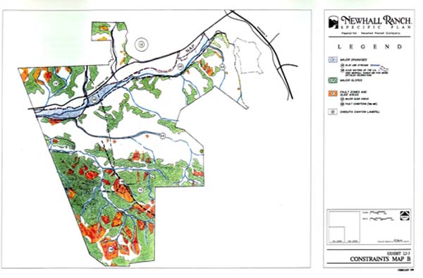
Newhall Ranch is the latest "new town" in the County of Los Angeles. GIS has been instrumental in the planning of this community, the future home for a population of over 65,000 people. FORMA Systems incorporated the full line of Esri software to identify, quantify, model, and analyze data to assist the planners in creating the Newhall Ranch Specific Plan. The cornerstones of the plan are the special management areas of the Santa Susanna Mountains' "high country" and the Santa Clara "river corridor," comprising more than 6,000 acres of preserved open space. FORMA Systems used ARC/INFO to document existing natural resources and their future value for preservation and enhancement. GIS defined compatible land use transitions and the "natural systems" integration of the community and the open space.
Introduction
Geographic Information Systems (GIS) have been traditionally used in large data set applications. The increase in electronic data being created, the computing power of desktop systems, and the functionality of Esri desktop software, makes GIS affordable and practical for small community planning efforts. Through better understanding and visualization of data, we can create more liveable communities that protect and integrate open space and natural resources.
Background
Location
Newhall Ranch is located in North LA County. The site totals 12,000 ACS. and is located directly west of Magic Mountain Theme Park and the City of Santa Clarita. The western boundary of Newhall Ranch is the Los Angeles and Ventura County Boundary. The upper north portion of site is bisected by route 126 and the Santa Clara River. The land owner and developer of the property is the Newhall Land and Farming Company.
Newhall Ranch Objective
The Mission Statement of the project is:
"Create a New Town in the Santa Clarita Valley that is designed to be a self contained community and to preserve and protect the natural amenities on-site." To achieve our mission statement, we set forth three major goals.
Goals
1. Design - Community Planning
| New Town 75,000 Population | Positive Public Benefits |
| Conservation Reserve | Significant Public Transportation |
| Preservation of California Heritage | Variety of Housing Opportunities |
| Hometown Tradition | Social Gathering Common Areas |
| Mixed-Use Community | Nearby Schools and Recreational Facilities |
| Integrated Open Space | Trail Systems |
| Jobs/Housing Balance |
To achieve these project visions required a unique community design,
a design which embraced the following:
GIS Support
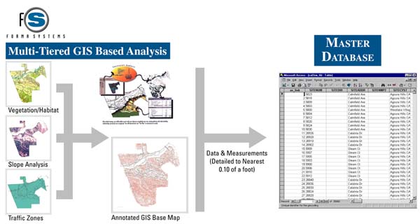
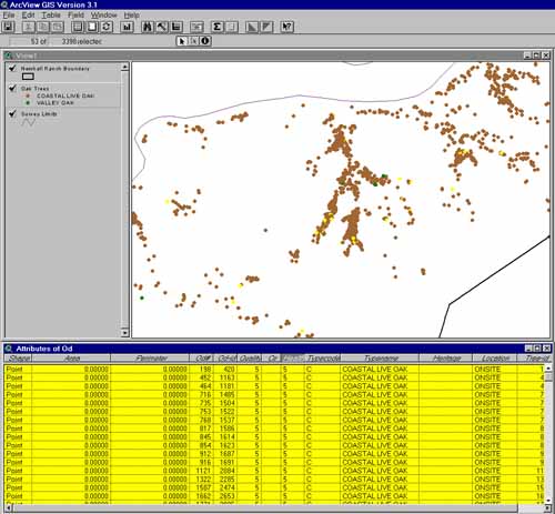
GIS played a key role behind the scenes in the planning process, beginning with the identification of vegetation habitat which ultimately defined the location and extent of development. Biologists set habitat values based on patch size, vegetation type, and location criteria. This data was converted into the GIS system, along with existing conditions and threatened species, which was digitized and incorporated into the ArcInfo library.
Issues addressed by the GIS System
2. Outreach Program
An Outreach Program is a key component of the development process. In
the beginning of the planning process public surveys were used to identify
what future residents may want in their "dream community". Later in the
process, community workshops were held to present ideas and to get community
input. GIS products were used to demonstrate flood plain issues and jurisdictional
boundaries in public meetings. GIS was also used to analyze the many design
alternatives that resulted from community input.
3. Environmental Analysis
All project-level environmental analysis was performed using ArcInfo and Arc View. This included: using ArcView to analyze location and health of trees, and the creation of Excel spreadsheets to monitor environmental values using ArcView attribute values. To provide for consistent data, region based coverages were utilized. Edit tools were invaluable in tracking the consistent stream of changes and modifications.
4. Fiscal Analysis
Fiscal considerations are important not only to the developer in determining
his "bottom line," but also to the jurisdiction. Newhall Ranch identified
the generation of surplus revenue for the County of Los Angeles as a key
benefit during the period of development, as well as after build-out. During
development, the project is anticipated to generate $304 million toward
the General Fund and $40 million directly for the community. At build-out
the development is estimated to generate an annual surplus of $21 million
for the General Fund and $3 million for the community.
GIS was used to analyze both the public fiscal impact and the internal Proforma for the developer.
To maintain confidentially for the developer, values from our central
GIS database were linked to an Excel spreadsheet and used to populate his
financial Proforma.
5. Entitlement
The last step of the our process is the entitlement process. This involved the County of Los Angeles (as lead agency), State of California and the Federal government.
There were numerous public site tours for the community and the decision makers. Using ArcInfo, we created maps and graphics for these tours. In order to communicate our project to the public and the Planning Commission and Board of Supervisors in public hearings, we used ArcInfo to track uses and acres, and displayed the information in a Land Use/Zoning matrix. Wall size final presentation graphics utilizing ArcInfo, helped to communicate the scope and diversity of the project.
Summary
ArcInfo and ArcView GIS are valuable tools in data management, generation of reports, and the preparation of valuable graphic information to assist in the Master Planning Process. A better understanding and visualization of data provides the opportunity to create more liveable communities that protect and integrate open space and natural resources.
Summary of GIS Tools
GIS Base
Topography
Ortho Photography
Proposed Grading Model
Jurisdictional Analysis
TIN
Regions
Environmental Resource Mapping
Interrelated Spreadsheets
Author Information:
H. Gene Hsieh
Principal
FORMA Systems
17500 Red Hill Ave. Ste 100
Phone: (949)-660-1900
Fax: (949)-660-9140
email: gene.hsieh@formacompanies.com