In early 1999, FORMA Systems completed a GIS Implementation Plan and is currently in the Phase II effort of leading Tejon Ranch into the 21st century with state-of -the-art software, hardware, and turn-key GUI solutions. The following is an abbreviate outline of the major steps involved in the implementation study.
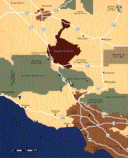
The 270,000 acre (421 square miles) Tejon Ranch is one of the largest privately owned properties in California. Historically, the Tejon Ranch has been an operating cattle ranch since the early 1800's. In addition to ranching, there are numerous other land uses such as agricultural, motion picture filming, and residential and commercial development.
1. Project Approach
a. Develop an efficient and cost effective plan based on Tejon Ranch business goals and FORMA
Systems extensive experience in both Geographic Information System deployment and land management and development.
b. Create a diversified GIS that is responsive to Tejon Ranch's full array of business components including:
finance, planning and development, property management, agriculture and ranching, and the filming industry.
c. Deliver immediate incremental products which demonstrate the proposed system capabilities.
d. Create the GIS to not only be an analytical tool but a business management and marketing communication tool.
e. Utilize existing Tejon Ranch hardware as much as possible. f. Create user-friendly applications accessible to all staff, regardless of technical background.
2. Needs Assessment
a. The needs assessment was the first step in implementing their successful GIS. The needs assessment was a systematic look at how each Tejon Ranch department functioned and the spatial data they needed to do their work.
b. Conducting a needs assessment also fostered cooperation and enhanced communication among each department by working together on a common technology and new set of tools.
c. Finally, the needs assessment activity itself served as a learning tool where potential users in each participating department could learn about GIS and how it can serve their department. The following core topics were evaluated:
1. Applications to be developed.
2. GIS functions required.
3. Data needed in the GIS database.
4. Data maintenance procedures.
5. Users of the GIS (individual and departmental).
6. Hardware and Software selection
7. Preliminary list of basemap data required of the GIS
-An array of both horizontal and vertical control points throughout the Tejon Ranch;
-Tejon Ranch boundary digitized from 1:24,000 scale USGS mylar base maps;
-Existing Easements (as provided by utility companies);
-Digital Raster Graphics of all 7.5 minute USGS quad sheets;
-USGS hydrography;
-USGS Digital Elevation Model and contours;
-Transportation (via commercial data such as Thomas Brothers or ETAK); and,
-Paved and dirt roads throughout the ranch (via GPS surveys and Digital Orthophoto Quads).
d. In summary, the final report included the following:
1. �Identify the accuracy requirements of the GIS;
2. �Identify the GIS priority areas and data layers, including data costs;
3. �Identify spatial and attribute data requirements, including data costs;
4. �Outline data and map inventory strategies and methods, including data conversion costs;
5. �Identify hardware and software requirements, including costs;
6. �Identify technical / user support requirements;
7. �Identify example desktop GIS interface "look" and "feel;
8. Outline the implementation schedule;
9. Identify personnel requirements, i.e., staffing and training, including costs;
10. Identify the organizational framework in which the GIS should be managed;
11. Identify constraints to the GIS implementation (if any);
12. Identify database maintenance and update processes;
13. Identify system maintenance requirements;
14. Describe ability to upgrade the GIS as technology advances;
15. Describe ability to expand systems to include future applications; and,
16. Make recommendations for a cost-effective phased GIS implementation.
3. Agriculture Uses of GIS.
In Ag, everything is about Net Acres. The key question is: What do you have and where is it?
a. Divide acres into Farm Management Units. Irrigation Sets; and/or Harvest Units
b. Ag uses are not only for the farmers but for management and outside vendors.
c. Build inventories for maintenance. For example, Pumps, reservoirs, wells, filtration systems, distribution lines. Attributes for pumps might include serial number, horsepower, and electricity usage.
d. Tracking of electricity and water usage.
1. Billing and fraud detection
e. Maintenance Scheduling and Budgeting
1. A closed loop accounting for a pump repair might �include:
a. GIS Work order -->Vendor -->GIS -->Accounting
f. Management of labor. What does it cost me to do certain functions? Typically, crew of 5 spends 6 hours pruning. What was the cost per acre? If a crew maps out the work completed, costs per acre can be calculated. Therefore, better labor and budget forecasting is possible.
g. Precision farming is a low priority for Tejon Ranch. �Efficiency gain vs. Cost to implementation must be considered.
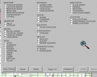
4. Custom Tejon Ranch Geographical Information System (TeRGIS)
The Easy-to Use interface allows users to see which themes are available within the Tejon Ranch GIS without browsing through tedious file dialogs. It allows the user to draw desired themes with a click of the mouse. The Main Draw Menu contains all coverages associated with the Tejon Ranch GIS.