Scouting the Route for the Eisenhower Parkway Extension
Michael J. Gilbrook
Abstract
As part of the Environmental Impact Statement for the Georgia Department of Transportation’s Eisenhower Parkway Extension project, HDR Engineering used ArcInfo and ArcView GIS to analyze potential environmental and cultural impacts for multiple alternatives. Viewshed analyses were particularly important to address potential impacts to the Ocmulgee Old Fields Traditional Cultural Property, the first such Native American land designated east of the Mississippi River.
Introduction
The Eisenhower Parkway Extension is a proposed Federal-aid highway project of the Georgia Department of Transportation in the vicinity of Macon, Georgia. To comply with the requirements of the National Environmental Policy Act (NEPA) of 1969, GDOT and the Federal Highway Administration must prepare an Environmental Impact Statement (EIS) for the proposed project. In 1997, GDOT selected a consultant team led by the Atlanta office of HDR Engineering, Inc. to conduct the environmental study and prepare the various EIS documents. This paper describes how HDR is using ArcInfo and ArcView GIS to support the NEPA process for the Eisenhower Parkway Extension EIS.
Study Area & Project Description
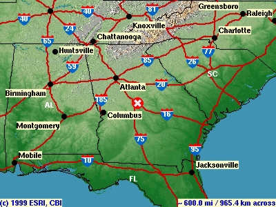
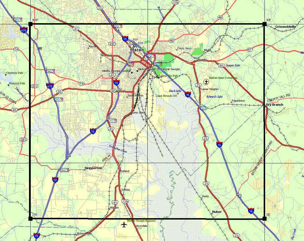
The study area is located in Macon, Georgia, about an hour’s drive southeast of Atlanta. The study area limits include the Macon East and Macon West USGS 7.5 min quadrangles, and the top third of the Warner-Robins NE and Warner Robins NW quads. The City of Macon is located on the Fall Line, the demarcation between the southeastern Coastal Plain and the higher elevations and more varied terrain of the continent’s interior.
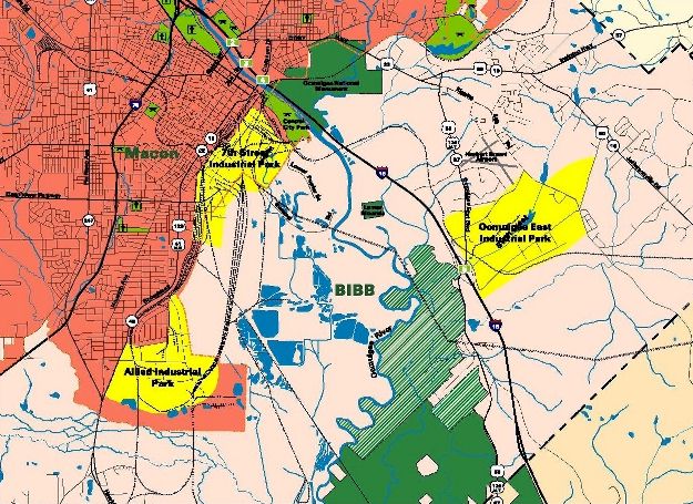
The current Eisenhower Parkway (also known as US 80) serves as a major east-west route from I-75 on the west, through the heart of Macon, and terminates on the east side of town adjacent to the 7th Street Industrial Park. For decades, various local interests have advocated an extension of Eisenhower Parkway to link up with State Route 57 east of Macon, thereby completing a link in Georgia’s Fall Line Freeway. However, that objective is only one minor component of the stated Purpose and Need for the project, which includes the following five objectives:
- Improve Transportation System Performance & Connectivity
- Enhance Transportation Access For Economic Development
- Improve Access to the 7th Street & Ocmulgee East Industrial Parks
- Provide A Less Flood-Susceptible Crossing Over the Ocmulgee River
- Reinforce Established Corridor Systems (STRAHNET, Fall Line Freeway)
The HDR Study Team is to identify a preferred roadway alignment which meets the stated objectives of the project’s Purpose and Need, while avoiding or minimizing harm to the area’s natural resources, cultural features and human populations. Ultimately, the costs and benefits of the preferred alternative will be weighed to determine if the project should go forward; if the project’s adverse effects are deemed significant, the final conclusion might favor a "No Build" alternative.
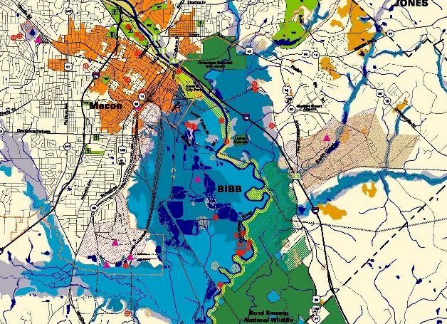
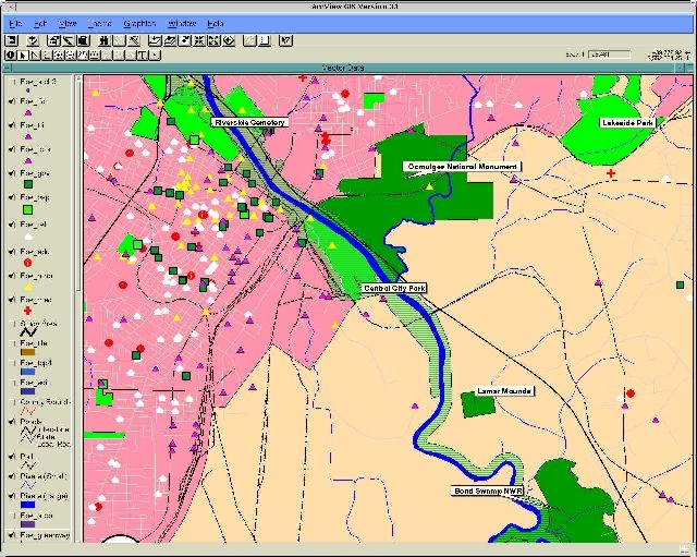
The study area is bisected by the Ocmulgee River, which flows into a wide floodplain to the southeast of Macon. This largely undeveloped area is referred to locally as the Ocmulgee Old Fields, and formerly supported a series of Native American cultures until the mid-1800’s, when the Muscogee Creek(Creek) were forcibly relocated from the land to their current home in Oklahoma. Today the Old Fields support an extensive forest ecosystem, but considerable archeological evidence of the area’s previous occupants are common. The most prominent Native American features are the earthen mounds and lodges constructed by the Mississippian people from 900 – 1150 AD; these structures are now protected as part of the Ocmulgee National Monument, managed by the U.S. National Park Service. The Bond Swamp National Wildlife Refuge, managed by the U.S. Fish and Wildlife Service, encompasses a large part of the southern study area along the eastern bank of the Ocmulgee River.
Due to their cultural and historic value to the Muscogee Creek(Creek) people, the Ocmulgee Old Fields from the Ocmulgee National Monument to the southern end of Bond Swamp National Wildlife Refuge are being considered for designation as a Traditional Cultural Property (TCP) by the National Register of Historic Places. This would be the first TCP identified east of the Mississippi River. The HDR Team’s archeological and cultural resource professionals, led by the staff at Brockington & Associates, have worked closely with state, Federal and Muscogee Creek(Creek) officials to define the TCP boundary. On 23 July 1999 the Keeper of the National Register issued her formal Determination of Eligibility for the TCP, including the final boundary description. Now that the TCP boundary has been established, and the TCP deemed eligible for listing in the National Register, all future Federal-aid projects (such as the Eisenhower Parkway Extension) must be evaluated for their potential impact to the historic value of the lands within the TCP.
Role of GIS in the Study
Using ArcInfo and ArcView, the HDR GIS staff in Orlando, Florida developed a GIS database for the Eisenhower Parkway Extension EIS. The database was prepared from a variety of public and commercial sources, including:
- Georgia Department of Transportation – Road network, hydrography, railroads, and utilities (1:24,000 scale)
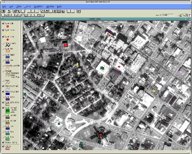
- US Geological Survey – Digital Elevation Model (DEM) data; Digital Raster Graphics (DRG); Digital Orthophoto Quarter Quadrangle imagery.
- US Environmental Protection Agency – Hazardous materials database with associated UTM coordinates (point coverage created using GENERATE).
- National Register of Historic Places – Point coverage of sites listed or eligible for listing on the National Register (created from UTM or geographic coordinates using GENERATE).
- Federal Emergency Management Agency – Digital Q3 Flood Insurance Rate Map data of flood prone areas.
- National Resource Conservation Service – Soil survey map data.
- City of Macon – Parcel ownership coverage (DXF format).
- SPOT Image Corporation – 10 m panchromatic imagery; LandClass18 land cover data.
- Space Imaging EOSAT – IRS-1C/Landsat TM fused imagery, in false-color IR and natural color.
- Wessex, Inc. – US Census 1995 TIGER line files.
- Claritas, Inc. – 1990 US Census data in INFO format.
These data were supplemented by new data collected by HDR’s GIS staff, through tablet digitizing (e.g., Bond Swamp National Wildlife Refuge boundaries), address geocoding (e.g., community facilities), and via heads-up digitizing on DOQQ imagery (e.g., proposed roadway centerlines). The GIS database was developed to serve three principal functions:
- Map resources & constraints – Using the GIS database, a variety of maps can be prepared for use by the study team, for inclusion in reports and for exhibits at public information meetings.
- Quantify potential impacts – The GIS can be used to quantify the relative potential impact of alternative roadway corridors and alignments through the study area. Resources to be considered included floodplains, wetlands, historic sites, historic districts, community facilities, conservation and recreational lands (so-called "Section 4(f)" lands), and the Traditional Cultural Property.
- Provide interactive ArcView GIS – Coverages used for spatial analysis and mapping with ArcInfo can be distributed to the planning and engineering staff as an ArcView GIS project to support on-site map preparation in the Atlanta office, as well as the ability to interactively view and query the GIS database during corridor and alignment identification. By bringing the ArcView GIS database to public meetings, it can also be used to support the study’s public involvement objectives.
Examples of GIS Use
The following examples illustrate some of the ways in which ArcInfo and ArcView GIS have been used to support the Eisenhower Parkway Extension EIS study:
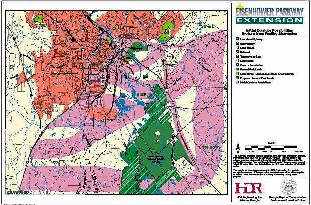
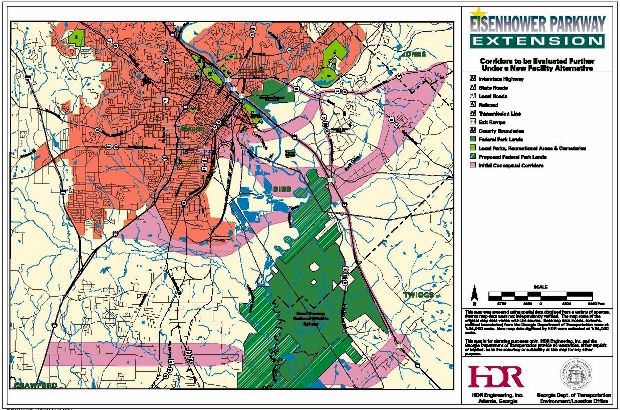
- Public Information Exhibits – GIS maps helped to illustrate the study process to the public. For example, a series of maps illustrated how the study team conducted the corridor identification process, starting with large corridor zones, followed by potential corridors within those zones, and ending with refined corridors to be evaluated further adjusted for known environmental and physical constraints.
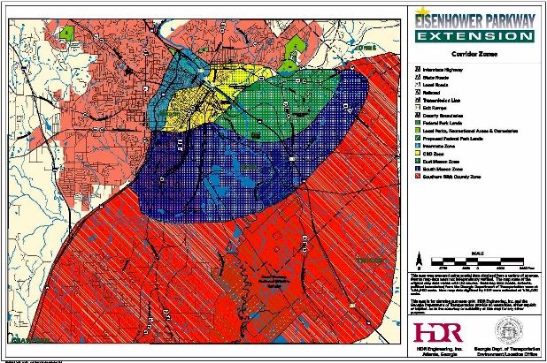
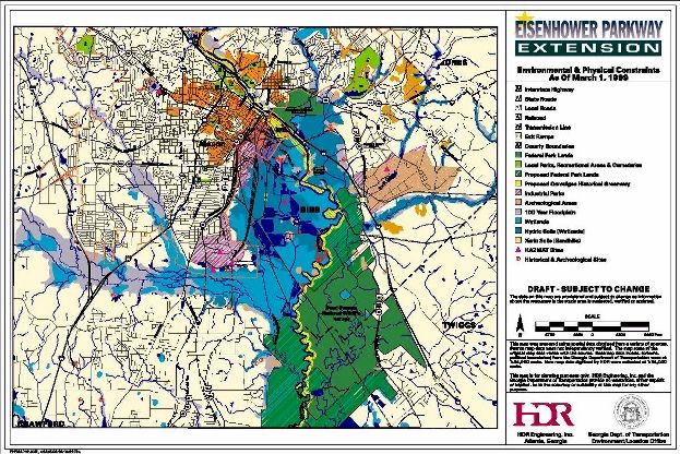
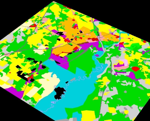
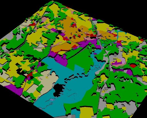
- Maps For Staff Use – The Environmental and Physical Constraints Map exemplifies the kind of GIS map which provides maximum information to engineers and planners as they consider alternative roadway locations which avoid or minimize impacts to known resources. This map combines data from many sources, including: floodplains, hydric soils, wetlands, xeric soils, historic districts, parks and conservation lands, archeological sites, and hazardous materials sites.
- Geocoding Community Facilities – During the initial stages of the EIS, the alternative corridors and alignments crossed a large part of the study area. Mapping the locations of community facilities such as hospitals, churches, schools, and fire stations by traditional means (i.e., sending crews into the field with maps to conduct "windshield surveys") was impractical. Instead, the HDR Team prepared a GIS tabular database of community facilities using readily available sources, such as the Internet and phonebook listings, which were used to geocode the sites to US Census TIGER street maps using ArcView. Following the ArcView geocoding, the location of each community facility point was adjusted as needed to coincide with the most probable building visible in the DOQQ imagery. This level of accuracy was sufficient for initial screening of alternative corridors; once the number of alternative alignments is reduced, field crews will verify the locations of facilities on hardcopy maps generated from the DOQQs for use in editing the community facilities coverage.
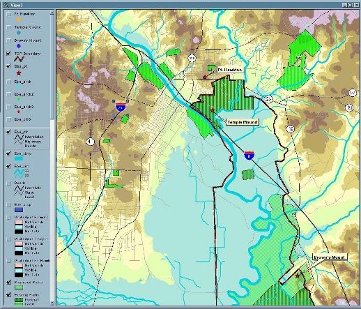
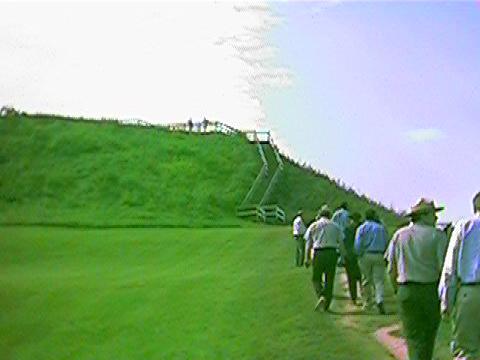
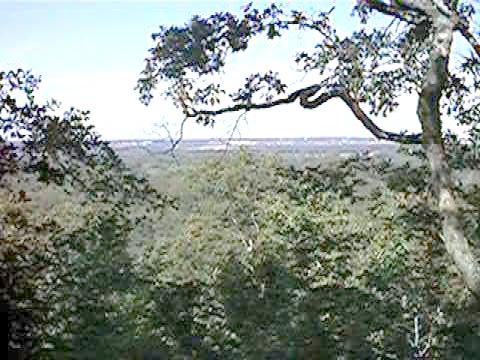
- Viewshed Analysis. To evaluate the potential impacts of the proposed project on visual aesthetics within the TCP, the HDR Team has been preparing a viewshed analysis using ArcView 3D Analyst. Three sites with prominent views of the TCP were selected for viewshed analysis: Fort Hawkins (an historic site in a Macon neighborhood), the Great Temple Mound (within the Ocmulgee National Monument), and Brown’s Mount (a natural area of high ground on the eastern edge of the TCP). The USGS Digital Elevation Model provided the relief of the ground surface, but did not account for visual obstructions such as trees and buildings. To adjust for surface obstructions, the HDR GIS staff assigned height values to the various land cover types throughout the study area. Combined with the DEM elevations, the land cover heights provide a more realistic surface for predicting intervisibility across the study area. At this writing the land cover height surface is still undergoing revisions based on photointerpretation and field reconnaissance. Nevertheless, the results of preliminary test viewsheds conform well to photographs taken from the three observer locations. For example, the preliminary viewshed analysis accurately predicted that the view to the southeast from the Great Temple Mound would be obscured by the nearby forest, whereas the buildings of Macon would be easily visible to the southwest.
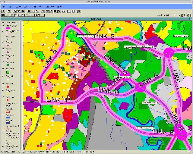
- Impact Quantification. As this writing, an impact quantification screening analysis has just begun on a series of alternative roadway "links" which might be later combined to form complete end-to-end alternatives across the study area. The purpose of this analysis is to provide preliminary information on potential environmental impacts, physical constraints and construction cost factors to help the team in winnowing out infeasible or impractical corridors from further study. The links were originally digitized by the Atlanta engineering staff in AutoCAD via heads-up digitizing on DOQQ imagery. Link centerlines were exported to DXF format for import into ArcInfo. Following assignment of attributes, the link centerlines were buffered to form corridors approximating the rights-of-way associated with multi-lane roadways, to address the potential "direct" impacts of each link. The links were also buffered by 500 feet to assess what resources might encounter potential "indirect" or long-distance impacts, such as noise. By overlaying the corridors onto the various resource coverages via INTERSECT, we obtained the amount of each resource within each link.
Future Steps
As the Eisenhower Parkway Extension study nears the release of the Draft EIS, the HDR Team will narrow the alternative roadway options to a Preferred Alternative. We will continue to use ArcInfo and ArcView to analyze potential impacts of alternatives. Following the elimination of unsuitable links during the screening analysis, the Team will discontinue the use of small-scale GIS databasets in favor of more detailed information collected from field studies (e.g., photointerpreted wetlands and wildlife habitat maps) to assess impacts. At that point, all data collection and drafting of proposed roadway rights-of-way footprints will be tied to the one meter DOQQ imagery. ArcInfo and ArcView will be used to generate nearly all the map figures to be used in the DEIS, and will continue to supply the majority of maps for public meetings. At the conclusion of the project, the ArcView GIS database will be delivered to GDOT along with all reports and maps, providing a complete digital record of the study.
Author Information
Michael J. Gilbrook
GIS Manager
HDR Engineering, Inc.
201 S. Orange Avenue, Suite 925
Orlando, FL 32801-3413
Voice (407) 872-7801
FAX (407) 872-0603
Email mgilbroo@hdrinc.com