Seung-mahn Ahn, Kyoo-seock Lee
The Survey and Analysis of Landscape Resources
at Muju Kuchon Valley in Mt. Teogyu National Park
ABSTRACT
In Korea, the national park is designated for preserving and conserving scenic landscape resources, and for visitors to enjoy those scenic views for recreation. So management goal is, that resources should be inherited to the following descendants because the current generation has inherited it from ancestors. In order to manage the national park effectively, national parks in Korea are classified into four zones - Natural Preservation Zone, Natural Environment Zone, Settlement Zone and Mass Facility Zone - based on the Natural Park Act. However, in Korea there is no definite criteria, and the data is not enough to manage the national park resources properly. For that reason, National Park management needs more accurate information. This study is done by an analysis of landscape resources in Mt. Teogyu National Park using GIS and RS with field survey, database construction. Based on the results of this study, the following discussions are derived.
1. Ecological fragmentation occurred mainly due to Muju Resort development and subsequent road construction. One road is under construction making serious deforestation.
2. Part of study area(10.69 km2) included in Wondang watershed needs to be included in the National Park. To manage National Park effectively, inclusion of this area must be accomplished.
3. Inaccurate data and lack of data. Based on Natural Park Authority data, total area of Mt. Teogyu National Park is 219km2. while that is 228.7km2 from 1:25,000 scale topographic map data. There is no wildlife habitat data. So ridge level is used for delineating wildlife habitat.
4. GIS integrated with RS provides helpful information for protecting scenic and valuable landscape resources in the study site. After performing this study, it was found that there are many valuable resources other than NPZ. So, more research based on the precise inventory of the current resources should be performed.
5. Additional survey and research needs to be done. This study is still in progress. Visiblity analysis needs to be done for landscape impact assessment.
1. Introduction
In Korea, the national park is designated for preserving and conserving scenic landscape resources, and for visitors to enjoy those scenic views for recreation. So management goal is, that resources should be inherited to the following descendants because the current generation has inherited it from ancestors. In order to manage the national park effectively, national parks in Korea are classified into four zones - Natural Preservation Zone, Natural Environment Zone, Settlement Zone and Mass Facility Zone - based on the Natural Park Act. However, in Korea there is no definite criteria, and the data is not enough to manage the national park resources properly. For that reason, National Park management needs more accurate information.
Therefore, purpose of this study is
1. To survey landscape resources of Muju Kuchon valley in Mt. Teogyu National Park to construct resource database using GIS, and RS.
2. To provide the reasonable ground for managing landscape resources of the study site to protect the area which has high biological diversity
2. Research Methods
2.1. Study Site
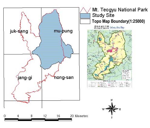
The study site is Wondang Watershed of Mt. Teogyu National Park which includes Muju Kuchon Valley, and 33 famous, historic, and fabulous scenic sites. Mt. Teogyu National Park was designated as the 10th National Park in Korea on Feb. 1, 1975.
Total Area of study site is 115.6 km2. As we can see in Figure 1, Mt. Teogyu National Park boundary was not delineated along the watershed boundary. So part of study area is not included in Mt. Teogyu National Park. So, 10.69 km2 of outside park area is included in the study site with 104.94 km2 of park area.
Figure 1. Muju Kuchun Valley Watershed
2.2. Study Procedure
Figure 2 shows the study procedure in this research.
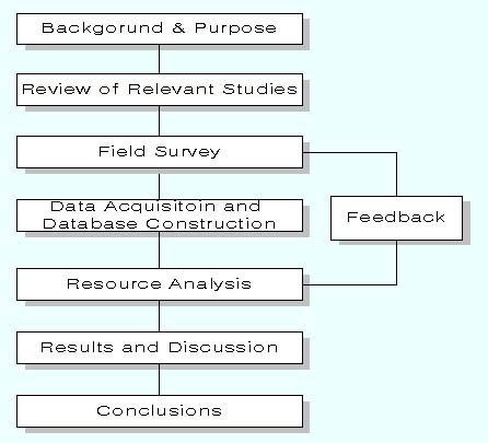
Figire 2. Study procedure
2.3. Input Data
In order to select thematic layer for analyzing landscape resources in Mt. Teogyu National Park, literature survey about former study of Mt. Teogyu National park was performed. Since 1993 more than 10 times of field survey were done to collect the necessary data.
Based on the field data, three types of landscape resources are selected. They are as follows.
1) To understand the current status of study site, watershed, zoning, landuse, and road network are surveyed.
2) To find an area with high biological diversity, forest stand, vegetation, and wildlife habitat are collected.
3) To preserve scenic area, sub-alpine meadow area, river corridor, are selected.
Table 1. shows input data used in this study.
Table 1. Input Data
Thematic Layer |
Scale |
Source data |
Type |
Attribute value |
DEM |
10m
X 10m |
Topographic Map |
Line |
Elevation |
Watershed |
1 : 25,000 |
DEM |
Polygon |
Watershed |
Road
|
1 : 25,000 |
Topographic Map |
Line |
Road distribution |
Stream network |
1 : 25,000 |
Topographic Map |
Line |
Stream distribution |
Fortst stand |
1 : 25,000 |
Forest Stand Map |
Polygon |
Forest stand , age, DBH, Canopy density |
Vegetation |
1:50,000 |
Current Vegetation Map |
Polygon |
Forest Community |
Zoning |
1 : 60,000 |
Park Visitor Map |
Polygon |
Zoning |
Landuse |
30m X 30m |
RSdata(Landsat TM) |
raster |
Landuse |
3. Results
Above data were entered in GIS, ArcView and ArcView Spatial Analyst, and RS system, PCI for deriving results.
3.1. Zoning
As we can see in Table 2, There are 96.3km2 for Natural Environment Zone(NEZ), 3.2km2 for Mass Facility Zone, 2.8km2 for Settlement Zone, 2.7km2 for Natural Preservation Zone, and 10.7km2 for Outside Park Area. NEZ covers nine tenth of study site excluding outside park area. Outside park has a separate zoning scheme. Most of the development activities occur within NEZ which may cause permanent destruction once developed. So, the present zoning does not seem to be well managed.
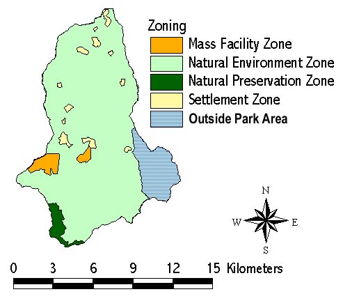
Figure 3. Zoning
Table 2. Zoning
Zoning |
Area(km2) |
Natural Preservation Zone |
2.7 |
Natural Environment Zone |
96.3 |
Mass Facility Zone |
3.2 |
Settlement Zone |
2.8 |
Outside Park Area |
10.7 |
Total |
*115.7 |
* : rounding error
3.2. Current Landuse and Ecological Fragmentation by Pavement Roads
To understand current landuse conditions, 30m resolution Landsat TM(115-35,1998) data were used for deriving land cover classification. Five landuse type, settlement, cultivated, resort, temple and forest are interpreted manually after image enhancement by stretching. As we can see in Table 3, the largest landuse type is forest whose area is 99.7km2. Then, it is followed by cultivated land with 7.1km2 , Muju resort with 7.0km2, settlement with 1.8km2, temple with 0.02km2. Temple and resort are easily distinguished because it is located within forest. However, the discrimination between settlement and cultivated area was not easy, so it was done by referring ground truth information.
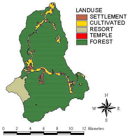
Figure 4. Landuse
Table 3. Landuse
Landuse |
Area(km2) |
SETTLEMENT |
1.8 |
CULTIVATED
LAND |
7.1 |
RESORT |
7.0 |
TEMPLE |
0.02 |
FOREST |
99.7 |
Total |
115.6 |
As we can see in Figure 4, and Figure 5, Muju Kuchon valley watershed(Wondang watershed)is fragmented ecologically by road construction due to resort development, and this trend tends to be worse. The cultivated area are located along the road. Now, Kuchon valley watershed is fragmented into four pieces. Figure 5 shows ecological fragmentation by pavement roads. The road between C and D does not seem to be fragmented in Figure 4. However, it was confirmed in the field survey that this road divides the area causing ecological fragmentation. The road between B and D is under construction making a serious deforestation.
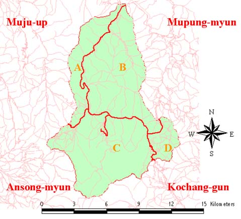
Figure 5. Ecological fragmentation by pavement roads
Table 4. Ecological fragmentation by pavement roads
Fragemented Site |
Area(km2) |
A |
15.9 |
B |
44.4 |
C |
48.2 |
D |
7.2 |
Total |
*115.7 |
* : rounding error
3.3 Wildlife habitat
In terms of wildlife habitat, 6 order , 15 family, 32 species of mammal are surveyed(Ministry of Domestic Affairs, 1993). As animal treasures(natural monuments) in Korea, Lutra 1. Lutra(otter), Moschus moschiferus parvipes Hollister(musk deer), and Pteromys volans(flying squirrel) are dedicated. And Ursus sp.(bear), and Canis lupus chanco(korean gray wolf), and Panthera pardust(Korean leopard)are endangered species. Two Panthera pardus(leopard)were captured in Mt. Teogyu, but cannot be found since 1963. Additional species, Sus scrofa coreanus Hude(Wild boar), Hydropotes inermis argyropus(Chinese water deer), Meles meles melanogenys Allen & Andrews(badger), Nyctereutes procynoides koreansis Mori(raccoon dog), are now surviving within park area. However, there were no habitat maps for these four species. So, the habitat map was made based on the degree of ridge after interview of national park management officials and residents. The ridge level is a important factor of wildlife habitat movement and habitat. Above four mammals move along 7/10 to 8/10 ridge level. So, above 6/10 ridge level to ridge line was delineated for protecting wildlife habitat. 10m x10m size DEM grid cell was used in ArcView Spatial analysis for this. As we can see in Figure 6 and Table 5, the area along around Hyangjokbong(1614m, peak), chungbong, Jibong, and Kochilbong are highly assumed to be wildlife habita. And it covers 47.2km2(40.8%) of study site. In wildlife habitat analysis Muju resort area was excluded because wildlife movement corridor was fragmented by it.
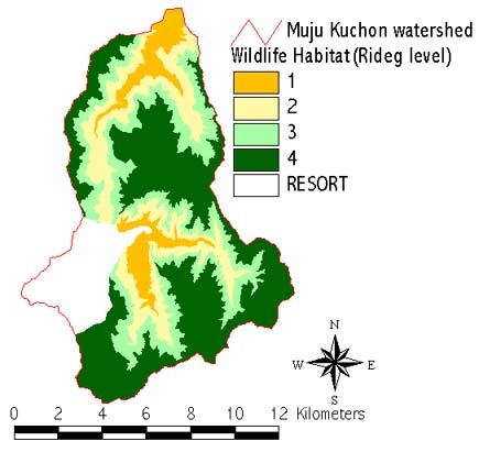
Figure 6. Wildlife habitat analysis from ridge level
Table 5. Wildlife habitat analysis from ridge level
Ridge Level |
Area(km2) |
~2/10 |
9.6 |
2/10~4/10 |
20.7 |
4/10~6/10 |
24.4 |
6/10~ |
47.2 |
Muju Resort |
13.6 |
Total |
*115.5 |
* : rounding error
3.4. Sub-alpine meadow landscape
The sub-alpine meadow landscape exists along ridge from Hyangjokbong to Samkeori. There are only a few sub-alpine meadow landscapes in Korea. So, this landscape needs to be preserved. There are unique, and diverse species of vegetation that can be seen in high mountain area. As herbs, Hemerocallis fulva(Day lily), Hosta longipes(Plantain lily), Sanguisorba ahkusanensis(Burnet), Bupleurum falcatum(Thoroughwax), Spergula arvensis, Peducularis resupinata(wood betony, Lousewort), Lychnis cognata(Lychnis), Gernium knuthii(Granesbill), Veratrum patulum(False hellebore), Synurus delteoides, Ligularia fischiry, and Astilbe Chinensis var. lilacina(False goatsbeard) grow(Kim et. al., 1994). As shrubs, Lespedeza maxinowczii(Bush clover), Lespedeza bicola(Bush clover), Rhododendron schlippenbachii(Royal azalea), Symplocos chinensis(Symplolcos Family), Sasa borealis grow. This landscape is worth preserving. As we can see in Figure 7, sub-alpine meadow landscape map was made by creating 200m width buffer zone along the ridge line. 200m is the maximum width of sub-alpine meadow landscape from ridge line. The hiking trail makes impacts and deteriorates the landscape because it crosses this landscape along the ridge line. So the necessary protection should be implemented.
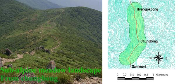
Figure 7. Sub-alpine meadow landscape
3.5. River Corridor landscape
In terms of river corridor landscape, Muju Kuchon valley which developed riffle fall, rapids, pool, and fond is in harmony with spectacular rocks. As we can see in Figure 8, there are 33 famous scenic sites. And excluding Hyangjokbong, Naje-tongmun, and Paikryun-temple, 30 scenic sites are distributed along the main stream. Only Naje-tongmun, and Paikryun-temple are Historic resource, and the other are Natural resource formed by erosion of rock or rock table.
200m width Buffer Zone is created done along the main stream in Kuchon valley watershed to preserve this landscape. Mass Facility Zone are excluded in delineation. 13.06 km2 area of study site is included in this river corridor landscape. As we can see in Table 6, this landscape includes 31 of famous 33 Muju scenic sites. Wolha-tahn is excluded in buffer zone because it is in Mass Facility Zone. This landscape is partially located in developed areas, roads, and forests.
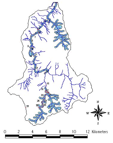
Figure 7. River Corridor landscape
Table 6. Muju 33 Scenic Resources Distribution
No |
Name |
Zoning |
Buffer |
Resource Type |
1. |
Naje-tongmun |
Natural Envrionment Zone |
Excluded |
cultural |
2. |
Eunkoo-ahm |
Natural Envrionment Zone |
Included |
Natural |
3. |
Cheongeum-dae |
Natural Envrionment Zone |
Included |
Natural |
4. |
Wahryong-tahm |
Natural Envrionment Zone |
Included |
Natural |
5. |
Hahksoo-dae |
Natural Envrionment Zone |
Included |
Natural |
6. |
Ilsa-dae |
Natural Envrionment Zone |
Included |
Natural |
7. |
Hahmbyuk-soh |
Natural Envrionment Zone |
Included |
Natural |
8. |
Gahyeui-ahm |
Natural Envrionment Zone |
Included |
Natural |
9. |
Choowol-tahm |
Natural Envrionment Zone |
Included |
Natural |
10. |
Mahnjo-tahn |
Natural Envrionment Zone |
Included |
Natural |
11. |
Pahoi |
Natural Envrionment Zone |
Included |
Natural |
12. |
Sooshim-dae |
Natural Envrionment Zone |
Included |
Natural |
13. |
Seshim-dae |
Natural Envrionment Zone |
Included |
Natural |
14. |
sookyung-dae |
Natural Envrionment Zone |
Included |
Natural |
15. |
Wolha-tahn |
Mass Facility Zone |
Excluded |
Natural |
16. |
Ieenwol-tahm |
Natural Envrionment Zone |
Included |
Natural |
17. |
Lion-tahm |
Natural Envrionment Zone |
Included |
Natural |
18 |
Chungryu-dong |
Natural Envrionment Zone |
Included |
Natural |
19 |
Beepah-tahm |
Natural Envrionment Zone |
Included |
Natural |
20. |
Dahyeon-dae |
Natural Envrionment Zone |
Included |
Natural |
21. |
Koowol-tahm |
Natural Envrionment Zone |
Included |
Natural |
22. |
Kumpoh-tahn |
Natural Envrionment Zone |
Included |
Natural |
23. |
Hotahn-ahm |
Natural Envrionment Zone |
Included |
Natural |
24. |
Chungryugye |
Natural Envrionment Zone |
Included |
Natural |
25. |
Ahnshim-dae |
Natural Envrionment Zone |
Included |
Natural |
26. |
Shinyang-dahm |
Natural Envrionment Zone |
Included |
Natural |
27. |
Myunggyung-dae |
Natural Envrionment Zone |
Included |
Natural |
28. |
Koochun Waterfal |
Natural Envrionment Zone |
Included |
Natural |
29. |
Paikryun-tahm |
Natural Envrionment Zone |
Included |
Natural |
30. |
Yeonhah Waterfall |
Natural Envrionment Zone |
Included |
Natural |
31. |
Leesohk-dae |
Natural Envrionment Zone |
Included |
Natural |
32. |
Paikryun-temple |
Natural Envrionment Zone |
Excluded |
Cultural |
33. |
Hyangjeok-bong |
Natural Preservation Zone |
Excluded |
Natural |
3.6. Forest landscape
There are four types of vegetation maps in Korea.
1.Degree of Green Naturality(DGN) Map
2.Detailed Survey of DGN Map
3.Current Vegetation Map
4.Forest Stand Map
DGN map and Detailed DGN Map are not appropriate for forest landscape analysis. The forest stand map contains information of forest stand, age, diameter of breast height(DBH), and canopy density while current vegetation map contains the structure of forest community only. So, at first forest stand map and current vegetation map were compared. However, the difference between Current Vegetation Map and Forest Stand Map is 52.km2 (45.1%) of study site as we can see in Figure 9. Additional survey and update are required to use forest stand map and current vegetation map, Future research is needed for forest landscape analysis.
Table 7. Difference between Current Vegetation Map and Forest Stand Map |
unit : are(100m2) |
Current Vegetation Map Legend |
Difference between C.V.Map and F.S.Map |
|||
Symbol |
Community |
Error(area) |
Error(%) |
Total |
No data |
No community Information |
16,729,000 |
99.9 |
16,746,700 |
PH0 |
Pinus rigida community |
2,561,000 |
79.1 |
3,236,100 |
PH5 |
P. rigida-L.leptolepis community |
1,464,500 |
60.3 |
2,427,700 |
CA0 |
Pinuus densiflora community |
13,536,800 |
91.1 |
14,859,800 |
PG0 |
Larix leptolepis community |
5,039,500 |
71.1 |
7,089,000 |
DA0 |
Quercus mongolica community |
4,683,600 |
9.1 |
51,205,600 |
DC2 |
Q.variabilis-Q. aliena community |
392,200 |
10.4 |
3,788,300 |
DC0 |
Q. variabilis community |
411,700 |
26.0 |
1,586,200 |
CA3 |
P. densiflora-Q.variabilis community |
1,912,800 |
39.2 |
4,879,100 |
DC6 |
Q.variabilis-P.densiflora community |
543,300 |
80.8 |
672,200 |
PG3 |
L.leptolepis-P.densiflora community |
920,800 |
81.1 |
1,135,700 |
DE0 |
Quercus acutissima community |
877,300 |
45.1 |
1,943,800 |
DA1 |
Q. mongolica-Q. serrata community |
707,900 |
78.1 |
906,500 |
DG0 |
Betula ermani community |
147,900 |
60.5 |
244,500 |
DY0 |
Fraxinus mandshurica community |
|
0.0 |
1,441,100 |
DE3 |
Q. acutissima-P.densiflora community |
94,400 |
29.9 |
315,800 |
DH5 |
C.laxiflora-P.densiflora community |
24,800 |
100.0 |
24,800 |
PF0 |
Pinus koraiensis community |
683,300 |
100.0 |
683,300 |
DF0 |
Quercus dentata community |
241,000 |
98.1 |
245,700 |
PO0 |
Castanea creanta community |
251,500 |
65.2 |
385,700 |
CA2 |
P.densiflora-Q.serrata community |
136,500 |
41.0 |
333,300 |
DB0 |
Quercus serrata community |
54,000 |
14.6 |
369,200 |
DI0 |
Carpinus tschomoskii community |
27,900 |
9.8 |
285,500 |
PG1 |
L.leptolepis-Q.mongolica community |
136,900 |
49.8 |
275,000 |
CA1 |
P.densiflora-Q.mongolica community |
9,300 |
60.8 |
15,300 |
CD0 |
A. koreana community |
138,700 |
100.0 |
138,700 |
CD2 |
A.koreana-Q.mongolica community |
163,000 |
100.0 |
163,000 |
DAG0 |
Rhododendron schlippenbachii community |
104,900 |
100.0 |
104,900 |
GK0 |
Grass land |
123,900 |
100.0 |
123,900 |
Total |
52,118,400 |
45.1 |
115,626,400 |
|
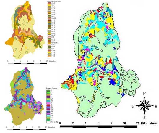
Figure 9. Difference between Current Vegetation Map and Forest Stand Map
4. Discussion
Throughout this survey and analysis, following discussions are derived.
1. Ecological fragmentation occurred mainly due to Muju Resort development and subsequent road construction. One road is under construction making serious deforestation.
2. Part of study area(10.69 km2) included in Wondang watershed needs to be included in the National Park. To manage National Park effectively, inclusion of this area must be accomplished.
3. Inaccurate data and lack of data
Based on Natural Park Authority data, total area of Mt. Teogyu National Park is 219km2. while that is 228.7km2 from 1:25,000 scale topographic map data. There is no wildlife habitat data. So ridge level is used for delineating wildlife habitat.
4. GIS integrated with RS provides helpful information for protecting scenic and valuable landscape resources in the study site. After performing this study, it was found that there are many valuable resources other than NPZ. So, more research based on the precise inventory of the current resources should be performed.
5. Additional survey and research needs to be done. This study is still in progress.
Visiblity analysis needs to be done for landscape impact assessment.
Reference
1. |
Lee, Chahng-hah, Seung-mahn Ahn, Kyoo-seock Lee, 1998, Comparison of Topographic, Vegetation, Scenic Resource Characteristics between Natural Preservation Zone and Natural Environment Zone in Mt. Teogyu National Park, Journal of Environmental Impact Assessment 7(1) : 49-61 |
2. |
Kim, Gab-tae, Joon-seon Kim, Gab-cheul Choo, Tae-won Um, 1994, Studies on the Structure of Forest Community at Natural Conservation Zone in Mt. Teogyu National Park, Korean Journal of Environment and Ecology 7(2) : 164-171 |
3. |
Oh, Koo-kyoon, Sei-cheon Kim, Kyung-jae Lee, 1994, The Present States and Management Proposal of Tokyusan National Park, Korean Journal of Environment and Ecology 7(2) : 270-295 |
4. |
Lee, Kyoo-seock, 1998, A study on the Effective Use of Environmental Information System-focused on the accuracy of raw data-, Korean Journal of Environmental Impact Assessment 7(2) : 27-35 |
5. |
Ministry of Home affairs, 1993, Natural Resources Survey in National Park - Mt. Teogyu National Park - |
6. |
National Park Association, 1997, Tokyusan National Park Natural Ecosystem Preservation Plan |
7. |
Kim, Seong-hee, 1994, The Analysis of the Natural Landscape of Kuchon valley in Mt. Teogyu National Park, M.S., Thesis at Sejong University |
8. |
Kwon, Tae-ho, Koo-kyoon Oh, Joon-woo Lee, 1994, Use Impacts on Environmental Deteriorations of Trail and Campsite in Mt. Teogyu National Park, Korean Journal of Environment and Ecology 7(2) : pp. 241-251 |
Seung-mahn Ahn
Graduate Student in Landscape Architecture, Sungkyunkwan University, Suwon 440-746, Korea
Tel : 082-331-290-7853
Fax : 82-331-290-7850
E-mail : oikos69@nature.skku.ac.kr
Kyoo-seock Lee
Dept. of Landscape Architecture, Sungkyunkwan University, Suwon 440-746, Korea
Tel : 082-331-290-7853
Fax : 82-331-290-7850
E-mail : leeks@yurim.skku.ac.kr