Janez Sturm, Primoz Kranjec
United Nations Economic Commission for Europe (UN ECE) - Trans European Railway with the Project Central Office (TER PCO) in BUDAPEST collects data concerning railways in Central and Eastern Europe. New technologies and current methods have induced us to rearrange the existing database to be more powerful and user-friendly. The project of database rearrangement was decided to be divided into steps including redefinition of data model, GIS design and Internet oriented application. The following paper surveys our previous activities on this project involving handling of the problems emerged during the work as well as future projections.
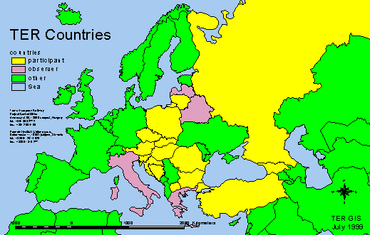
On the area of Central and Eastern Europe railway companies are mostly state or government owned institutions. This induces the fact that they are very rigid for new waves and also that they are more or less supported through taxes and subventions. Recently borders have become more open, which results in greater demand for close co-operation in wide range of fields. International organization UIC from Paris covers legislation and regulation in technical fields, which is insufficient for successful business. Bilateral and multilateral connections between governments are the basis for closer co-operations between domestic and non-domestic operators on certain links across two or more countries. At the same time have some bottlenecks occurred on infrastructure networks and also on transport part. Some railway traffic corridors are craving for investments in order to be adequately competitive. We need to mention that there is some intention to extend borders of European community, which is going to provide not only technical compatibility but also political compatibility on the level of operators and infrastructure. There are quite a few reasons to establish an international project in this particular field.
Trans-European Railway Project is a descendant of the UN. They work in compliance with the UN direct supervision of Economic Commission from Geneva (transport division). This means strict rules and obligations. The first task is to establish an international database with periodical data update. It is imperative for the data to be veritable in order to pave the way for efficient pre-feasibility studies. TER Project Central Office is lokated in Budapest.
Founded thirty years ago, the Prometni institut focuses on transport systems transport planning and economics in general, as well as on technical and information processes in railway transport. The policy is to cover both transport research and development projects in theoretical and applied research. The orientation and previous projects has led the Government of Slovenia, Ministry of Traffic and Communication to the decision that PI is the right company for elaboration of the technical work on rearrangement of TER information system.
The main reason of data collecting is to have a compatible database, which is fed with data from different Central and Eastern European countries as a base of elaboration of pre-feasibility studies. It was achieve from the representatives of participant countries to design the model of the database and apply it in MS Excel software. The nature of this particular software induced some inevitable problems, which brought about an immense work on both sides especially in TER project central office in Budapest. Some problems occurred in definition of particular database fields and their interpretation. TER PCO stuff faced a big problem when trying to merge data from several Excel files into one unified database due to the lack of uniformity of data. They needed to fit the data which was time consumptive, so using up goodwill of all participants.
TER PCO first requirement was to improve data collecting process. We suggested them use such kind of software, which allows better data fields definition and appurtenant contemporary database manipulation must be feasible, because of dislocation of national databases. With the old organization of data collecting, a lot of time was spent in the office to arrange data in one database and to make a technical revision.
The second requirement was to use GIS and possibility to make thematical maps directly from the database and the possibility to use Internet for data maps distribution.
The third requirement was to use the input masks directly on the Internet. In future this convenience could shorten the time needed to collect data.
The fourth requirement was similar to the third. In the future it is desired to have interactive thematical maps directly accessible on Internet. There is also a wish to devise a system, which would be open designed for future technologies and also other programmer’s groups.
The limitations are also conditioned by the organization of the project. TER stuff is paid directly by national governments from countries where particular people come from. The government of Slovenia decided to pay some money for rearrangement of the TER information system. This is reason that we are very short with financial resources.
Our proposal was based on using new information technology, which will ensure the results of work to be focused apart from data collecting to analyzing and using the data. We suggested using database software with GIS connection, which allows us to prepare Internet solutions in future.
The rearrangement of TER information system was split to four steps:
- preparing input mask application
- Geographic Information System
- preparing input mask application on Internet
- Geographic Information System on Internet
The proposed steps were accepted from TER PCO with two remarks that before we start we need to rearrange data model technically and contextually.
On this way we expect the work in TER PCO in the future will to be more focused out of collecting but in analyzing and using the data. This means that people could do more work in the same time.
Before we started to work on preparing input mask application, the data model was rearrangement. According to the content data were split to operators and infrastructure part and by confidential to first and second part. Because this information data model is also base for GIS use so, by topology data was split to points, arcs and polygons.
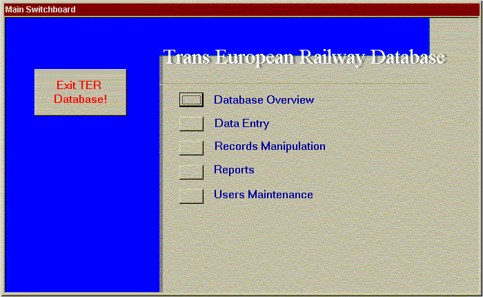
For input mask application was chosen program MS Access, which is already widely used and has enough capabilities for this proposes. The application was made from several screens, which allowed users to easily found right mask.
Main switchboard contains five navigation buttons and an exit button for closing the application (Exit TER Database). Navigation buttons enable the user to perform various tasks of data manipulation:
- Database Overview: overview of data in forms
- Data Entry: data manipulation (adding, deleting, changing of data)
- Records Manipulation: bulk updates of data
- Reports: structured overview and print out of data
- Users Maintenance: maintenance of users and their permissions
On next picture you could realized that we want to prepare easy as possible application.
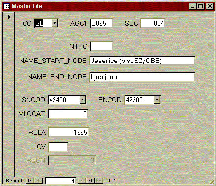
The forms are to be found by navigating through the tree structure, which reflects semantic affinity between the data in the tables. Tables was divided to four groups:
A. Infrastructure
- Master File (base for point and links)
- Line Section (data about lines)
- Nodes (data about stations)
- Bridges (data about bridges)
- Tunnels (data about tunnels and galleries)
- Overpasses (data about overpasses)
- Level Crossings (data about level crossings)
B. General Information
- General data (data about countries)
- Codes (codes of corridor overlaps)
C. Operations
- Operational Data (data about national operator)
- Combined Transport (data about combined transport)
D. Rolling Stock
- Locomotives and Railcars (data about traction vehicles)
- Coaches (passenger vehicles)
- Wagons (freight vehicles)
All of this tables we split in tree topographical groups. Master file is base for preparing base cover for links and stations and tables which contains data of participant countries is base for polygons.
Second step of rearrangement of TER information system is preparing possibility of using alfa-numeric data in geographical forms. Because of amount of data and accuracy we suggest to use dynamic segmentation for geo positioning data.
First of all we split all tables in tree topographically different groups: points, lines and polygons. Points and lines were positioning by using base cover, which allowed users to use dynamic segmentation with software Esri ArcView.
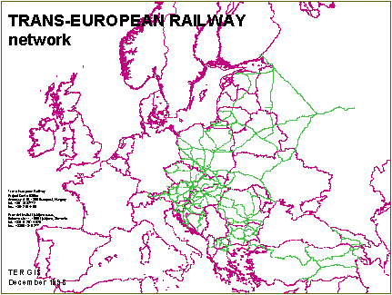
Preparing of base links cover was hard work. First of all we couldn’t use national geographical data about rail network because they didn’t fit together. Different countries use different coordinating system and it is impossible to use data. We need to prepare entire cover on the same base global coordinating system. After that we split links according to Master File to shorter parts with unique number, starting and ending kilometer position.
Second noticed is that data came with software Esri ArcView are not enough accurate for this purpose. The borders of Europe countries have mistake to 20km. This is reason that we need to prepare another cover, which is more accurate and fit with base link cover.
From organization point of view we suggest that in TER PCO prepare covers for each table, make shape and distribute with Esri ArcExplorer and project for it. But before we need to do next job.
From organizing point of view we prepare some base ArcView projects which allowed people from PCO to make dynamic segmentation with Esri ArcView and save data to shape file. Some thematical maps are also made on advance. We expected that in near feature people from PCO would work only with our technical support and make own maps depend on request. Because of dislocation we also prepare the same computer environment for help stuff in PCO and make much better analyses on the same data.
The 3rd step we planed to arrange input mask on Internet server that people from different countries could directly put the data to TER PCO location. This means faster working with online support and especially less delay on sending data.
The 4th step is to make also thematical maps on Internet. This will be from our point of we the best advertising for this particular region of the word to make more money on transport with railways. We expected that some data will be free of charge and different people from direct investors to users of transport facilities could see own opportunities to make business. Our wish is also that we do not wait to long to this step.
In this project we work with different countries, which have at least not similar GDP. There is also much different development of economy and also history, which allowed it. There are also organization rules according to UN which protect less powerful countries to have some influence.
There is also fact worth to mention that the government of Republic Slovenia wants to expose new rail connection between Slovenia and Hungary and financing first step of this project.
In this particular paper we want to show that some international project are also possible never the less that participant countries are definitely different and producer need to be very careful with preparing such kind of task. There are not only technical but also main organization problems occurred which need to be solving before start to make application.
1. Janez Sturm, VMESNIK MED ORODJEM ZA IZDELAVO GEOGRAFSKIH INFORMACIJSKIH SISTEMOV PC ARC/INFO IN PROGRAMOM ZA NAPOVEDOVANJE PROMETA QRS II, Diplomska naloga, Univerza v Ljubljani, FAGG, 1990
2. Janez Sturm, Dusan Fajfar, Bogdan Zgonc, GEOGRAFSKO INFORMACIJSKI SISTEM SLOVENSKIH ZELEZNIC, Gradbeni vestnik #: 11-12/1993
3. Janez Sturm, TEHNICNA IN ORGANIZACIJSKA ZASNOVA GEOGRAFSKEGA INFORMACIJSKEGA SISTEMA NA SISTEMU SLOVENSKIH ZELEZNIC, Magistrsko delo, Univerza v Ljubljani, FAGG 1994
4. Janez Sturm, Poster: RAGIS, Poster Session of International Esri User Conferece, Palm Springs USA, 1995
5. Janez Sturm, ZASNOVA GEOGRAFSKEGA INFORMACIJSKEGA SISTEMA PODJETJA SLOVENSKE ZELEZNICE, Mednarodni znanstveni kolokvij: Upravljanje prometa, 5.4.1995, Univerza v Mariboru
6. Janez Sturm, ZASNOVA GEOGRAFSKEGA INFORMACIJSKEGA SISTEMA PODJETJA SLOVENSKE ZELEZNICE d.d., Letno porocilo, Prometni institut 1995
7. Janez Sturm, ZASNOVA GEOGRAFSKEGA INFORMACIJSKEGA SISTEMA PODJETJA SLOVENSKE ZELEZNICE d.d., Letno porocilo, Prometni institut 1996
8. Janez Sturm, Poster: RAGIS, Poster Session of International Esri User Conferece, Palm Springs USA, 1996
9. Janez Sturm, Poster: SLOVENIAN TRANSPORT MASTER PLAN, Poster Session of International Esri User Conferece, Palm Springs USA, 1996
10. Janez Sturm, ZASNOVA GEOGRAFSKEGA INFORMACIJSKEGA SISTEMA PODJETJA SLOVENSKE ZELEZNICE d.d., 5. mednarodni znanstveno - strokovni simpozij o elektroniki v prometu ISEP 96, 10.-11. oktober 1996, Zbornik referatov, Elektrotehniska zveza Slovenije
11. Project: SLOVENIAN TRANSPORT MASTER PLAN - Final Report, Prognos AG Basel & Prometni institut Ljubljana, 1996
12. Project: Vzpostavitev informacijskega sistema slovenske zelezniske infrastrukture, FGG-Prometno tehniski institut in Prometni institut Ljubljana d.o.o., 1997
13. Janez Sturm, Geographic Information System of Slovenian Railways Co. International Esri User Conferece, San Diego USA, 1997
14. Janez Sturm, RAZVOJ APLIKACIJ GEOGRAFSKEGA INFORMACIJSKEGA SISTEMA ZA SLOVENSKO ZELEZNISKO INFRASTRUKTURO., 6. mednarodni znanstveno - strokovni simpozij o elektroniki v prometu ISEP 97, 9.-10. oktober 1997, Zbornik referatov, Elektrotehniska zveza Slovenije
15. Project: Vzpostavitev informacijskega sistema slovenske zelezniske infrastrukture, FGG PTI & Prometni institut Ljubljana d.o.o., 1998
16. Project: Trans European Railway - development of information system / step 1, Prometni institut Ljubljana d.o.o.,1999
17. Trans European Railway Database, Data Entry Application TER_APP ver. 1.0, User’s Manual, Prometni institut Ljubljana d.o.o., 1999
APR - ArcView Project
AV - Esri ArcView
EU - European Union
GDP - Gross Domestic Product
GIS - Geographic Information System
MS - Microsoft Co.
PCO - Project Central Office in Budapest
PI - Prometni institut Ljubljana d.o.o. (Institute of Traffic and Transport Ltd.)
TER - Trans European Railway Project
UN - United Nations Organization
Janez Sturm, M. Sc., C. E.
Senior Researcher
Prometni institut Ljubljana d.o.o.
Office in Celje
Ulica 14. divizije 2, 3000 Celje, Slovenia
tel.: +386 63 29 33 350, fax.: +386 63 29 33 801
E-mail: janez.sturm@guest.arnes.si
Primoz Kranjec, M. Sc., E. E.
Senior Researcher
Prometni institut Ljubljana d.o.o.
Kolodvorska 11, 1000 Ljubljana, Slovenia
tel.: +386 61 29 14 626, fax.: +386 63 319 277
E-mail: primoz.kranjec@guest.arnes.si
United Nations Organization
Trans-European Railway
Project Central Office
Andrassy ut 66, POB 732, 1365 Budapest, Hungary
tel.: +361 353 2772, fax.: +361 269 4195
E-mail: uneceter@mail.matav.hu