Farmers in the central Great Plains require accurate spatial information to assess land suitability for alternative cropping systems. Agri-FACTs (Agricultural Farm Analysis and Comparison Tool) is a Web-based GIS application providing convenient access to soils and weather data supporting suitability analysis of cropping system alternatives. This tool supports ongoing collaboration among ARS, NRCS, and university scientists, along with CIESIN personnel, to integrate agro-ecozone modeling with cropping systems research for future risk assessment applications.
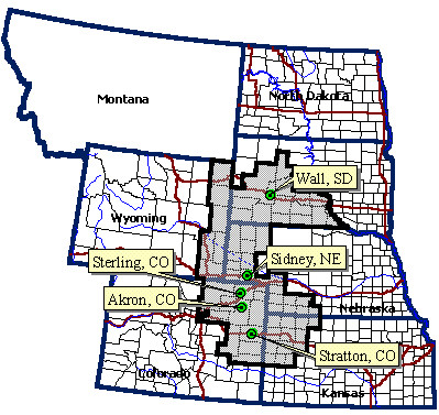
At present, five research sites located throughout the central Great Plains study region are involved in alternative cropping system research. The central Great Plains study region falls within a five state area; Colorado, Wyoming, South Dakota, Nebraska, and Kansas. Alternative cropping system research currently being conducted at these sites are demonstrating substantial increases in annual yields due to improved soil quality and available water. However, given that there are only five research sites as well as a high degree of variation in soil properties and climatic characteristics, producers question how far experimental results can be extrapolated across the region. Therefore, landscape level soil and climatic data is required to infer potential success of different cropping system alternatives at any location in the central Great Plains region. Enabling the producer to make informed decisions regarding the implementation of new cropping systems requires the comparison of soil and climatic factors at the farm level to the soil and climatic factors found at each cropping systems research site. Central Great Plains farmers need an accurate GIS based tool to evaluate the risks associated with changing land use (cropping systems) on their farms.
The goal of this project is to provide the farmer with a Web-based coarse level spatial data visualization and decision support system called Agri-FACTs (Agricultural Farm Analysis and Comparison Tool) uses the Spatial Analyst and ArcView Internet Map Server (Esri, Inc.) extensions. Agri-FACTs is intended to provide convenient, user friendly, and accurate access to soils and weather surface models and data that are relevant to suitability analysis of cropping system alternatives. USDA Agricultural Research Service (ARS) and USDA Natural Resource Conservation Service (NRCS) research scientists and CIESIN personnel have been working together to integrate NRCS agroecoregions modeling with ARS cropping systems research within the central Great Plains and distribute the data to the farmer. Agroecological factors such as soil quality and weather related risks affect the suitability of a particular farm location to intensive/alternative cropping practices. This type of research information is typically unavailable to farmer, but may greatly assist the farmer in decision making regarding the potential of implementing new cropping systems on their farms.
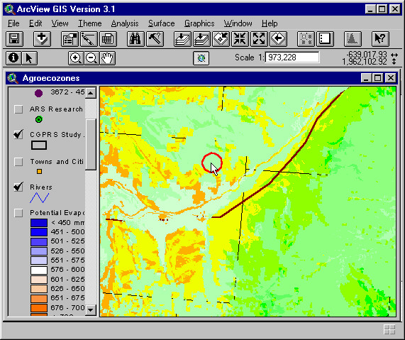
The Agri-FACTs program was created using ArcView 3.1, ArcView Avenue, ArcView Spatial Analyst extension, and the ArcView Internet Map Server (IMS) extension with an HTML graphical user interface. We chose the ArcView IMS because the system deals with large raster datasets. Map Objects IMS does not have the GRID analysis capability that was required for the system. Using ArcView 3.1 with the Spatial Analyst and ArcView IMS extentions allowed Agri-FACTs to operate very quickly and accurately.
Original surface models were tranformed from a GRASS GIS format into an Arc/INFO GRID format and reprojected using Arc/INFO 7.1. Agri-FACTs also exists as a stand alone ArcView project.
ARS cropping systems studies are currently located at five sites in the region: Akron, CO, Stratton, CO, Sterling CO, Sidney, NE, and Wall, SD. Each research site is conducting independent cropping systems studies. For example, at the Akron Research site, scientists are evaluating different cropping rotations such as wheat-corn-corn, wheat-corn-proso millet, and wheat-proso millet. At the Wall, SD research site, successful rotations include wheat-sunflower-proso millet and wheat-field peas-proso millet. There is a wide variation of soil properties and climatic characteristics between the sites. For example, annual precipitation can vary from 300 mm (approximately 12"/year) on the western side to 600 mm (approximately 24"/year) on the eastern side of the central Great Plains study region.
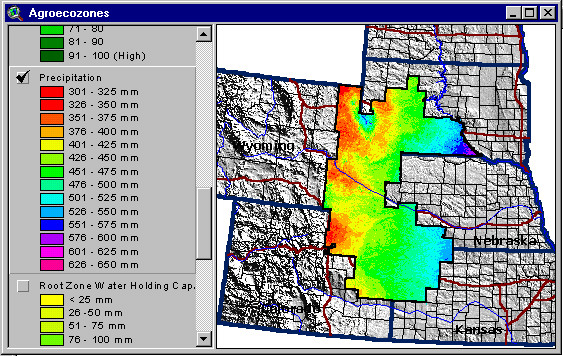
Six different soil and climatic factors were modeled across the central Great Plains landscape at the NRCS National Soil Survey Center in Lincoln, NE. Three of the modeled surfaces deal with soil properties; 1. Root Zone Water Holding Capacity (RZWHC), 2. Soil Rating for Plant Growth (SRPG), and 3. Annual Water Balance (AWB). Three climatic characteristic surface models include; 1. Precipitation (PRECIP), 2. Potential Evapotransporation (PET), and 3. Growing Degree Days (GDD). These data were considered essential in terms of agricultural cropping system analysis in the central Great Plains. The climate and soil surface models were developed using complex regression techniques from point data such as weather station and soil pits (pedons) as well as NRCS vector soils data (SSURGO and STATSGO) and nonspatial relational databases. Below are examples of the PRECIP and RZWHC surface model within the central Great Plains study region.

The Agri-FACTs HTML report displays the values for all six models (PET, AWB, SRPG, PRECIP, RZWHC, and GDD) for the selected farm point. The report allows the farmer to individually compare each of the soil and climatic values found at the farm location to the soil and climatic values found at each of the five research sites. The farmer can then determine which research station(s) has the most similar soil and climatic characteristics to their farm. The report contains hyperlinks to each of the experiment stations allowing the farmer to go directly to the research site's web pages and examine the cropping system research results. It is at this level that Agri-FACTs facilitates decision support regarding new cropping systems that the producer may elect to consider for his farm to replace the wheat-fallow system most commonly used. The farmer can then take this information to his extention agent or district conservationist for a more explicit analysis.

Future directions for the Agri-FACTs spatial decision support system include automated risk assessment analysis. This would allow the farmer to choose a specific cropping system for their farm location. The system would calculate the statistical probabilities of success by including climatic variation, soil properties, and crop species requirements. Another addition will be the ability to perform cropping system analysis and risk assessment at field the level. Zooming into indiviual farm fields requires large scale contextual data such as MrSID formatted digital orthophoto quads, property/field boundaries, roads, and drainage themes. Another goal is to eventually expand the analysis capability to the entire central Great Plains region which includes all of Montana, North Dakota, South Dakota, Nebraska, Kansas, Wyoming, and Colorado.
Agri-FACTs is a web based GIS application that was developed as a coarse level decision support for farmers within the central Great Plains region to analyze alternative cropping systems for their farms. Agri-FACTs integrates agro-ecozone modeling with cropping systems research and made available to the farmer with ArcView IMS and an easy to use graphical user interface. Agroecological factors such as soil quality and weather related risks affect the suitability of a particular field to alternative cropping practices. This type of research information is typically unavailable to farmer, but may greatly assist the farmer in decision making regarding the implementing alternative cropping systems on their farms.
Robert M. Aiken (Main Contact), Research Crop Scientist, Northwest Research-Extension Center, 105 Experiment Farm Road, Colby, KS 67701-1697. Phone: 785.462.6281 Fax: 785.462.2315 Email: raiken@oz.oznet.ksu.edu
Vernon L. Thomas, GIS Analyst/Applications Development, CIESIN, PO Box 2027, Fort Collins, CO 80522. Phone: 970.490.8387 Fax: 970.490.8399 Email:vthomas@ciesin.colostate.edu
William Waltman, Research Coordinator, Nebraska Research Initiative on Geospatial Decision Support Systems. 113 Nebraska Hall, CALMIT, University of Nebraska, Lincoln, NE, 68588-0517. Phone: 402.472.9984, Fax: 402.472.4608, Email: bwaltman@tan.unl.edu