Udo Kachel & Mohammad Kurdi
WAJ with 260,000 customers in the capital Amman introduced a corporate GIS to improve efficiency of water / wastewater operations & customer management. The virtually non-existing address information in Amman necissitated the use of ARCINFO cadastral base maps for geographic location of customers, to be integrated with existing customer databanks, developed under ORACLE and COBOL.
Applications introduced cover customer address confirmation, inspected maps & work order sheets, route planning tools for meter reading, bill distribution & revenue collection, unaccounted-for-water analysis and sewer connection monitoring.
Concrete revenue improvement in the first year of introdution amounted to more than 650,000 $, total improvement potential on recurrent basis is estimated at 2 mio. $ per annum, resulting in payback periods for GIS investments of less than 2 years.

Since 1994, the GTZ Operations Management Support Project (OMS Project) to the Water Authority of Jordan (WAJ) assists WAJ in restructuring and commercializing WAJ business processes.
First priority was to transform the Amman Governorate Water Administration (AGWA), responsible for the water & wastewater services of 1.6 Mio people, to an autonomous, commercially run entity.
All analyses, proposals and the implementation activities were carried out together with the line function staff of WAJ, thus guaranteeing a realistic, down to earth approach.
This very challenging task was documented in over 100 working and concept papers for the reorganization and redesign of the user procedures, and resulted in handing over the management of AGWA to a private operator.
The centre pin of all these activities was the establishment of an integrated, GIS based information management system to facilitate and support the change management process with neutral and substantial data & information.
The Water Authority Subscriber Organization was suffering from:
The virtually non existing municipality address information prompted all organizations to come up with their own solutions to satisfy the needs of their internal procedures.
The Water Authority of Jordan subscriber solution was to invent a very large geographical boundary and try to number the customers inside according to the reading round sequence.
New customers were identified by the nearest customer without any plausibility on the correct customer address. Off course, this resulted in missed sequences because of the continuous arriving and departing of customers from the customer data base in addition to the extreme dependence of all line functions on a single customer service line function, the meter reading and reader.
The water operations & subscriber organizations were continuously confronted by outdated unusable maps. This hampered and delayed the network maintenance and new customer connection procedures.
On the other hand the information flow about new customers was not organised in closed circles which resulted in continuously disappearing customers from the system. The way the customers were identified and numbered resulted in misplacing customers in the wrong area with negative impact on the percentage of unread meters (20%).
The manual sewerage customer data base prevented any kind of sewerage payment follow up or control. Consequently, millions of JD’s were not collected from customers.
Similarly, the caught illegal water consumption cases annual average were only 263 (JD 56.000, US$ 79.000).
The attitude of the meter readers was of utmost supremacy since they are the experts in the field. To find a customer in the field was like trying to catch a single specific fish in the wide ocean. Thus, the follow up, discipline and control over them was frequently compromised, and virtually impossible.
Therefore, it was absolutely necessary to break these barriers and come up with a better business like solution.
The common denominator of the majority of the problems was the missing up to date geographical and network information (i.e. the new water customer address) or the complete absence of any computer data base (i.e. sewerage customers).
The solution had to come through bottom up approach of cleaning up and making order from the line function level.
The only way corporate GIS structures can be productive and be usable is to address and go deep into the lowest line function deficiencies.
In this respect, the user needs had to be identified which meant reviewing the working procedures step by step to finally pin point the step where GIS can give the service and be part of the business process.
The fact that not all users had a clear documentation of their procedures in addition to their limited know-how of what GIS can offer made this task more difficult.
Parallel to this, the creation of the missing data bases (i.e. sewerage, operations, valve) and the modification of the existing ones (i.e. COBOL billing system) had to start.
The overall bad quality of data necessitated an extensive Comprehensive Subscriber Survey (CSS) which also included the updating of the cadastral maps. Further step was to modify the COBOL billing program (COBOSS) to accommodate the geographical information requirements so that all data bases can be linked based on the map information.
Last application to be developed was an ORACLE data base (SDS) for the 70.000 sewerage customer records. All those single stand alone applications were incorporated in the overall AGWA Corporate GIS based Information Management System called ANIS.
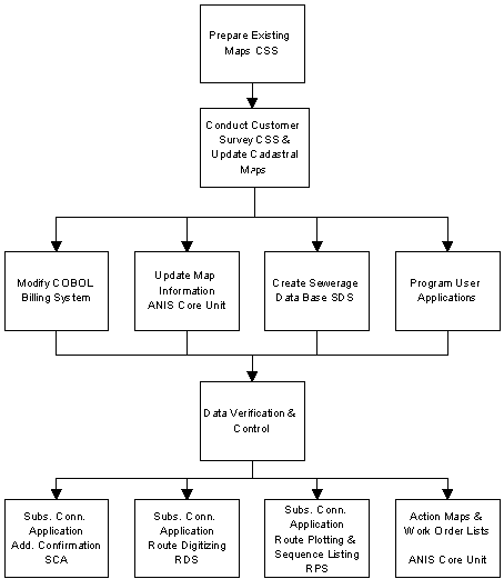
To realise the concept on the ground, several preparatory steps had to be done.
The flow chart shown below is a very simplified and compacted one. In reality each box represents a huge task by itself.

The fundamental step was to update the cadastral maps since they are the basis for all other information. Thus, part of the CSS Project responsibilities was to update these maps in order to facilitate accurate field data gathering.
This huge project had to be staffed with the qualified map surveyors, dynamic computer data base, strong vehicle fleet and a lot of patience and perseverance.
The intensive contact with the public required appropriate media campaigns.
Open dialogue channels with the Dept. of Lands & Survey (DLS), the Housing Development Dept. (HUDD) and the Dept. of Palestinian Affairs were very important to complement the missing or unclear map information.
Additionally, all working procedures including information flow diagrams with customer services had to be fixed and documented.
CSS completed surveying 270.326 customers living on 145.284 plots within 2 years. Parallel to this, the sewerage data base SDS was designed and programmed. The data entry of the sewerage files was the most delicate step since it had repercussions on the customer payment. Therefore, a data entry form was designed to be filled in an earlier step. SDS now contains all 70.000 sewerage customer files.
The COBOL billing program (COBOSS) is one of the old computer systems at WAJ.
For COBOSS to be integrated in ANIS, modifications on the software were necessary. The digital address, route structure and the related reading and billing programs had to be modified in addition to the creation of management information controlling indicators.
The standard reading routes had to be documented from the field and digitized.
With the definition of the user needs and preparation of the procedure description and documentation, the design , programming and testing of the application modules took place, as well as the related office reorganisation.
The three Subscriber Connection Application (SCA) modules were programmed by Infograph (Jordan’s authorized Esri dealer).
The customer application procedure was characterized by:
The new GIS Address Confirmation module uses the customer address information from his/her official documents and checks if this address exists in the data base.
The address information comprises of six fields as defined by the Jordanian Dept. Of Lands & Survey in addition to a seventh field for the needs of further address identification (Sub-plot).
Once this code is verified and concatenated, it is then used to display the plot and the needed information layers on screen. The address code is entered into the COBOL billing system after the confirmation of the address through a separate terminal in order to monitor and control the customer file flow and establish the link with GIS at the earliest steps of the connection procedure.
The user can select the needed layers depending on the case being handled and then prints the Inspection Map Form & As Built Form.
The two forms are added to the new customer file for further connection and meter installation procedure steps.
Upon final connection and installation, the As Built Form is used to draw the connection details and sent back to the ANIS Core unit for network updating.
The meter reading procedure was characterised by:
The new GIS SCA-RDS application facilitated the digitising and storage of the valuable route description information. Not only this, but it had the possibility to reverse direction and change the sequence of the respective plot in a certain route.
This dynamic tool tore down the shrouds and provided transparency to all other subscriber line functions (i.e. Meter Division, Inspection Division) in addition to opening wide doors for What if analysis? A task which was almost impossible in the past.
The SCA-RPS application prepares the ASCII file which contains the route description to be exported to COBOSS. Additionally, the user can produce a route map for his procedures. With this map, it is now possible to separate between the reading and bill distributing procedures since both were done by the same person.
With the final conclusion of the CSS Project, all surveyed customer addresses are transferred to the billing system. The system in turn produces address oriented reading lists by linking the address information from CSS with the route information from GIS.
On the other hand, COBOSS monitors bill printing and distributing by means of a bill running number and bill distribution list which requires signature from the customer for receiving the bill or remarks from the meter reader about the fate of the bill.
The subscriber & sewerage management were missing the chance to exchange their information due to the missing unified address. This resulted in missing the opportunity to collect large amounts of money.
By utilizing and using GIS based tools and information in both business processes, the information flow between all data bases became smooth and yielded excellent results.
The valuable actual information from the field as collected by CSS was compared with the stored information in both the billing and sewerage systems.
By establishing the links through the address, it was possible to produce maps and work order sheets which highlighted the actions to be taken on a certain address.
(i.e. Illegal water consumption, water supply from neighbour, additional flats constructed without sewerage payment)
The realised amounts from this were excellent as shown in the results section.
This particular application is standardised by the ANIS Core Unit staff depending on the map theme. The maps and work order sheets are then handed over to the user for follow-up.
Before any matching principle to be attempted, the updating of the maps in ANIS- as delivered by CSS- and the confirmation of the digital address between CSS data base and ANIS had to be done. All surveyed customers by CSS must be located on a map in ANIS. Therefore, the cadastral map updates by CSS had a significant value for ANIS and comprised the foundation for customer address location.
After updating of maps in ANIS and the confirmation that all CSS customer addresses are existing, it is now possible to transfer the customer digital address to the billing system.
The problem of mismatching between customer collection area and water supply service area evolved from unclear service area boundaries, outdated network maps and the subjective decision concerning the point of connection between the customer house connection and the water network.
A customer could very well be within the service boundary of provider A (WAJ Governorate A), but paying the bill to provider B (WAJ Governorate B) and vice versa.
With the decision to award the Management Contract for Greater Amman Water & Waste Water services to a private operator and separate it financially from the main governmental body WAJ, the need to clean up these boundary exceptional cases became of top priority.
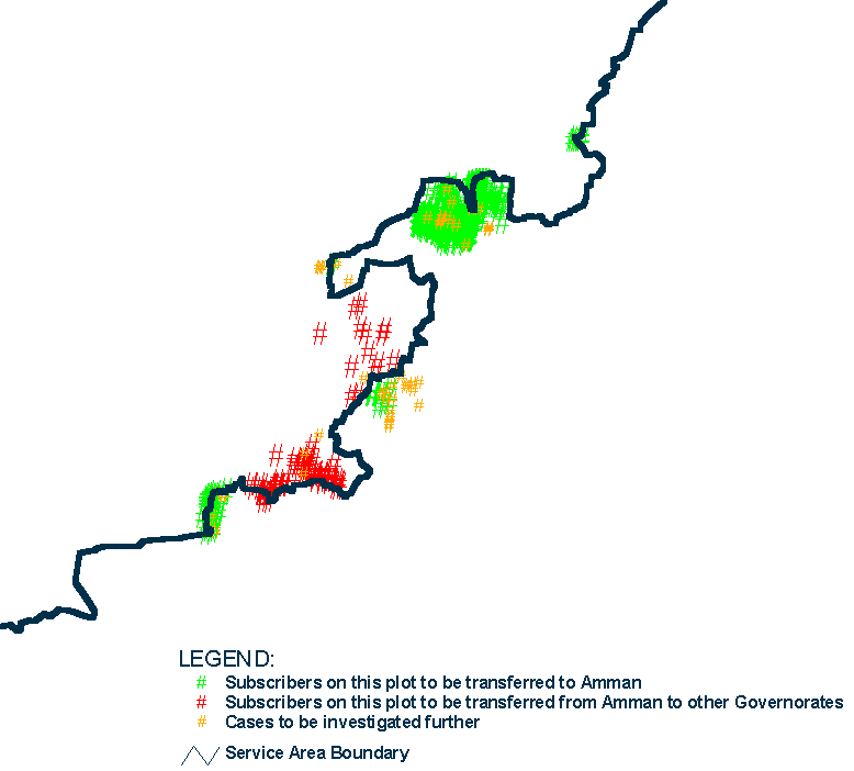
The analysis of this problem was done by linking the customer survey database (Oracle) and ArcView, classifying the customers into three categories and reflecting the results on a map (see Fig. 2):
Category A Customers managed and billed by another Governorate but residing in areas which are within the private operator jurisdiction. (Customers to be imported-Green Color)
Category B Customers managed and billed by Greater Amman Administration but residing in areas outside the private operator jurisdiction. (Customers to be exported -Red Color)
Category C Addresses which contain unclear cases to be further investigated-Light Brown Color)
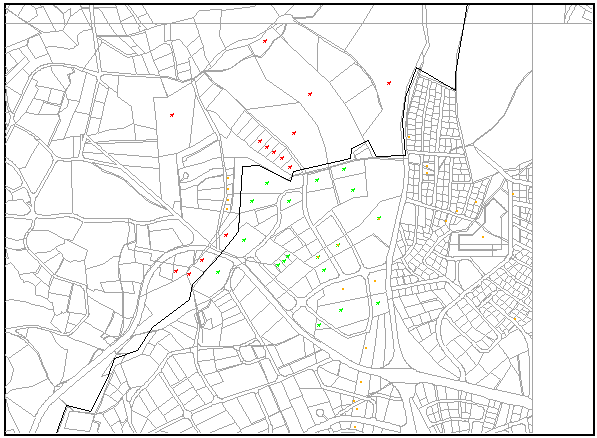
The following figures show the three cases to be transferred or checked further. Aided by maps and lists, the user was able to act promptly on this valuable information and start the swapping task.
The result of this analysis was the importing of 816 customers to Amman and the exporting of 72 to other Governorates. A total of 49 customer cases are to be investigated further and cleared.


The main objective of the CSS Project was to update the cadastral map information, create the missing maps for some parts of the governorate and establish the geographical link with customers.
The result of CSS is updated cadastral maps for all Amman Governorate, creating the missing maps for the un-surveyed areas in the past and the surveying of all 270.000 customers by identifying their digital address and linking it to GIS.
Nevertheless, the field survey was a golden opportunity to collect additional useful and valuable information. As a result, the customers connected to the sewerage network but not being billed were identified. The realized amount for this from 1/1/98 until 31/3/99 is 282.404 JD (US$397.752).
The sewerage data base now has 70.000 entered customer records with the established link to GIS. By establishing the missing link with the COBOL billing system and CSS information through the GIS digital address large amounts of additional revenue are realized.
The number of flats is used for the calculation of payments due by the sewerage data base.
By only comparing the number of flats added through the GIS link, 2.309.403 JD(US$3.252.680) are realized from only 315 customers. It was not possible in the past to make such a link despite the numerous manual attempts.
On the other hand, the speed of the sewerage procedure has improved to 5 minutes to physically retrieve a sewerage file.
By modifying the COBOL billing system and changing the new customer procedure, the number of disappearing customers was reduced to zero. The percent of unread meters was reduced by half 100.000 JD(US$140.845). The number of caught illegal water consumption cases doubled with emphasis on big consumers 254.251 JD(US$ 358.100).
Although opportunity costs should be part of a real cost/benefit analysis, and are often used to justify GIS-IT investments, WAJ-AGWA did not even need to consider that in the balance sheet presented in the following Table.
The financial benefits related to the introduction of GIS based customer management applications are so obvious and striking that ANIS is financing itself without such fictitious calculations.
Action |
Staff involved |
Time period |
Costs JD |
Benefits JD |
|||
Application |
no. |
years |
one time |
recurring on yearly basis |
one time |
recurring on yearly basis |
|
Add sewerage charges lost customers |
55 |
2.2 |
-220,000 |
- |
- |
282,404 |
|
CSS |
|||||||
Charge sewerage connection fee |
10 |
1 |
-7,000 |
- |
2,309,403* |
- |
|
ANIS / SDS / CSS |
|||||||
Reduction of unread meters |
2 |
1 |
-2,000 |
- |
100,000 |
- |
|
COBOSS / RPA |
|||||||
Illegal Consumers caught |
4 |
1 |
- |
-28,000 |
- |
254,251 |
|
COBOSS / RPA / SCA |
|||||||
Hard/software procurement Documentation + running cost |
15 |
1 |
-295,000** |
-150,000 |
- |
- |
|
ANIS + all applications |
|||||||
TOTAL |
-523,000 |
-178,000 |
2,409,403 |
536,655 |
|||
in US$ |
-747,000 |
-254,000 |
3,393,525 |
767,000 |
|||
* The real potential is much higher. This amount represents only 315 customers from an area of 84 km2 only. The service area comprises approx. 2,900 km2, out of which approx. 600 km2 are densely populated.
** The total establishment & running costs for ANIS have been added. When considering benefits on the operations & maintenance sector, lower figures could be used.
The financial figures as shown in the cost/benefit table clearly illustrate the huge advantages of an integrated, GIS based Information Management. It needs to be mentioned, however, that the conditions in AGWA at the start of the GIS/database activities in 1995 were extemely bad.
If a GIS is introduced in a better organized and well run water utility, the financial benefits may not be so obvious and pay back periods longer.
Nevertheless we still did not use the full potential of the GIS technology and believe to even increase the productivity once ANIS has been fully established.
Application / Action |
Staff Involved |
Total period Months |
Cost (JD) |
Amounts One Time (JD) |
Amounts Recurrent (JD) |
ANIS / CSS / COBOSS |
55 |
28 |
220.000 |
282.404* |
|
ANIS / SDS / CSS |
10 |
12 |
7.000 |
2.309.403** |
|
COBOL |
2 |
12 |
2.000 |
100.000 |
|
Documentation |
6 |
6 |
6.000 |
||
Total |
235.000 |
2.409.403 |
|||
US$330.985 |
US$3.393,525 |
* The value survey and production of previously not existing base/network maps for south Amman and the southern service area.
** The real number is much higher. This amount represents only 315 customers from an area of 84Km2 (13%). Greater Amman area is 622Km2 to be investigated.
The idealistic approach to first generate a clear and accurate map basis, before building GIS applications, has not been followed in ANIS. Right from day one, the focus stayed on practical business applications, created to improve a desastrous situation in the customer management of Amman Water.
The financial success of the combined CSS/ANIS paved the way for a much more comprehensive, integrated information management system. ANIS shows, that the effects of a consequently applied GIS development are much bigger when the operating conditions in an organisation are really bad.
An efficiency run organisation and business process will not have tangible benefits of such nature in short time.
Thanks to all the field workers and data entry people in the CSS, who created the basis for our success.
Udo Kachel, Team Leader (Author) Mohammad Kurdi, Advisor Organization & Methods
Studies (co-author).
Operations Management Support Project to the Water Authority of Jordan, PO Box 941308,
Amman 11194 Jordan, Tel./Fax (962-6-5686960), e-mail: Udo_Kachel@mwi.gov.jo, Mohammad_Kurdi@pmuoms.index.com.jo