| Shahbaz Raza
Michel Lettré Importance of MdProperty View for the Local Update of Census Addresses (LUCA) ProgramAbstract: As part of Census 2000, the U.S. Census Bureau has developed a program with local governments to review the census master address list. The objective of this Local Update of Census Addresses (LUCA) program is to improve the accuracy and completeness of the Census Bureau's master address file before mailing the census questionnaire in March 2000. The Maryland Office of Planning is the principal state agency providing technical assistance to 18 counties and their municipalities participating in the Census Bureau's 1998 LUCA program. The Office of Planning has developed ArcView GIS-based project files as a supplemental LUCA CD-ROM (using ARC/INFO and ArcView GIS software as the primary software) that works with its statewide property database called MdProperty View. The LUCA CD-ROM contains the 1990 census block and LUCA housing counts linked to the block boundary map and the residential parcel data highlighting both pre- and post-1990 developments for each block. Using these products from the Maryland Office of Planning, jurisdictions can readily generate a list of property addresses for a census block that can then be compared to the Census Bureau's list of addresses for that corresponding block. Additions / corrections to the Census Bureau's list can then be made based on this comparison.Introduction
To MdProperty View
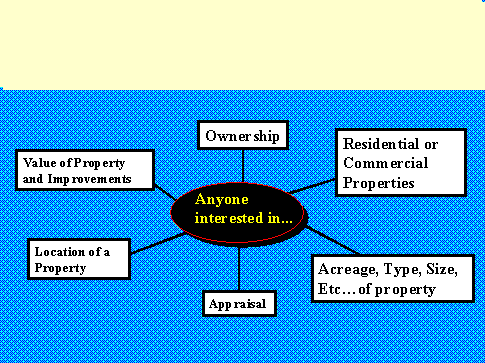
MdProperty View serves as a key component of Maryland's spatial data infrastructure, providing the foundation upon which other State agencies, local government and the private sector can build their own geographic information system in a cost effective and sustainable way. The integration of raster and vector map and data products provides a cost-effective solution to meeting the increasing demands for spatial data for improved decision-making by government and the private sector. Those who work with property-specific data or who do location analysis have found the MdProperty View tool exceptionably valuable. In particular appraisers, surveyors, realtors, builders, foresters, utility companies, community interest groups, and those who provide flood insurance have made extensive use of MdProperty View. Other applications include: neighborhood investment and revitalization initiatives; agricultural and land preservation; emergency management; disposition of surplus real property; 911 addressing; transportation and land use planning; economic development; crime analysis; and natural resource and environmental protection (see Figure 1 & 2). 1. MdProperty
View Data Structure
MdProperty View is setup with all data sets spatially referenced using the NAD83 meter in State Plane Coordinate System (SPCS) as required by Maryland State Government Geographic Information Coordinating Committee (MSGIC). This makes MdProperty View product consistent with other State agency GIS data layers. While the data is in NAD83 meters, all distance units in the project files are set to be displayed in feet. The CD-ROM contents and ArcView project files may be accessed directly from the user's CD-ROM reader (recommended minimum speed 16x and 32 MB of RAM). Otherwise the user must copy the CD-ROM contents to the same directory or subdirectory on their hard drive before accessing the data sets using the project files and ArcView software. All data sets have been verified as complete and operational through the use of the ArcView 3.0 "project" files (*.APR). Use of the information on the CD-ROM with other mapping applications may be possible but is not directly supported by the Maryland Office of Planning. The following sections describe some image and data layers available as part of MdProperty View database for each jurisdiction in Maryland: 1.1 Land Satellite image
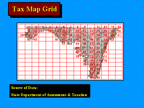
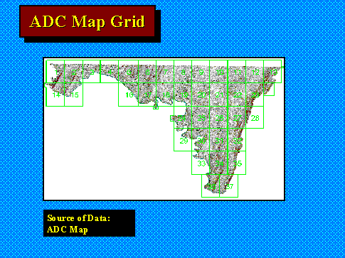
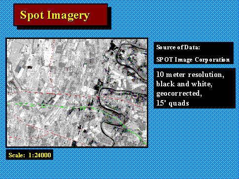
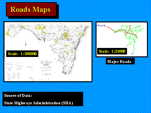
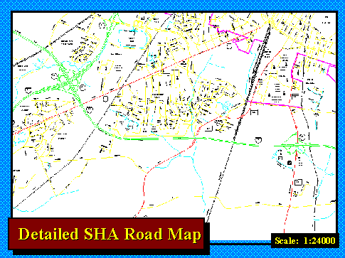
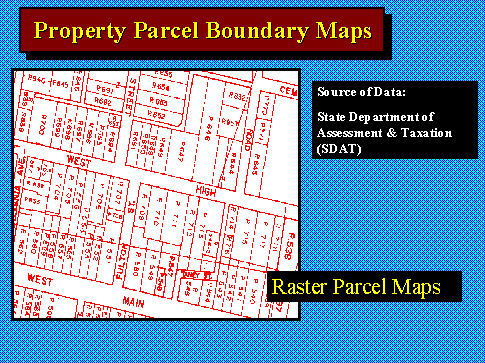
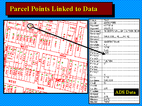
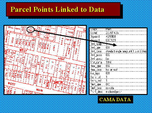
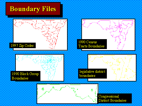
1.2 Tax Map Grid: Jurisdiction Index of Maryland State Department of Assessments and Taxation Parcel Maps (see Figure 4). 1.3 ADC Map Grid: Jurisdiction ADC map book page reference grid, resource being used by a majority of Realtors (see Figure 5). 1.4 Digital Spot Satellite Imagery: Black & white, 1995 satellite images with 10-meter resolution (see Figure 6). 1.5 SHA Road Maps: State Highway Administration (SHA) digital 1:24000 grid maps of roads, rails, stream and boundary features for each county and Baltimore City. SHA digital grid maps conflated to the U.S. Bureau of the Census TIGEr/Line files with expanded feature names and address range information incorporated in with the street network for each jurisdiction in the State (see Figure 7 & 8). 1.6 Property Maps & Ownership of Land: The State of Maryland has traditionally maintained 2,800 property maps (generally 1:7,200 scale maps with insert maps for towns at smaller scales) in the form of ink on Mylar originals. These maps were converted to digital format using scanning technology. The maps are now maintained as a hybrid of the original raster scans with vector updates for new subdivisions and property boundary changes (see Figure 9). To make the computerized property maps intelligent, each property map was geographically aligned to the State Highway Administration's 1:24000 scale digital roads file. A x,y reference point was then located in each parcel on the property maps such that it also fell on the correct side of the digital roads file. The referenced points were linked via a unique identifier to the corresponding parcel database record for the property (see Figure 10 & 11). 1.7 Boundary Files: Following boundary files are available as ArcView shapefiles: Census Tracts - 1990 enhanced (1:24,000) census tract boundary files and associated 1990 census population, housing and socio-economic data from the U. S. Bureau of the Census 1990 STF1 and STF3 files. Block Groups - 1990 enhanced (1:24,000) block group (subset of a census tract) boundary files and associated 1990 census population, housing and socio-economic data from the U. S. Bureau of the Census 1990 STF1 and STF3 files. Political Boundaries - Congressional and State legislative district boundary files as adopted based on redistricting after the 1990 Census (boundary files are based on the 1990 Census TIGEr/Line files, 1:100,000 at best) (see Figure 12). 2. MdProperty
View Project Files (APRs) Setup
2.1 Master project File
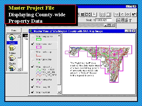
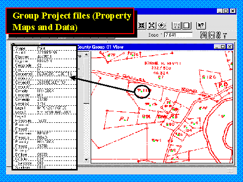
Master View: This view contains all of the frame of reference data sets (selection overlay, property map grid, Landsat image, SPOT images, major roads, SHA roads, and land/water boundary) for the jurisdiction. The master view also includes the jurisdiction's "gisc" file that contains all located and unlocated parcels along with key fields for locating properties countywide by account number, owner name or street address. For the first time with the 1999 Edition, the master project files will also include a seamless, composite (cataloged) image of all of the property maps for the jurisdiction which eliminates the need to access and load the individual property map images that are provided in the GROUP PROJECT FILES. Unlocated Properties View: This view contains the detailed assessment files ("unlc") and CAMA files ("cmul") for those parcels, which could not be, located on the property maps. Since these parcels have x,y coordinates with 0, -1, or -9 values they cannot be viewed in any meaningful way on a jurisdiction map and instead can only be looked at as a table from within the view. The selection overlay theme (the magenta colored grid) must be the "active" theme in the master view before the automatic selection of any study areas can be accomplished. When the lightening bolt (Hotlink tool) is selected, the user can move the icon to any of the numbered areas on the selection overlay. Once within the area of interest click the left mouse button. This action will automatically import property map images and the associated parcel database records (both the standard assessment database extract and the CAMA database) into another view within the master project file (see Figure 13). Along with the master project file (described above), there is another version of the master project file. Users can select one of these master project files based on their requirement and application. This project file contains the frame of reference data sets, SPOT satellite imagery, detailed SHA roads, and stream. Like the master project file, this project file also has the selection overlay theme to import group project files by using the Hotlink tool in ArcView. 2.2 Group Project Files
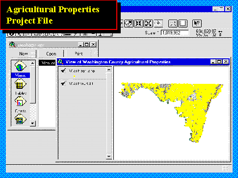
2.3 Agricultural Properties Project File
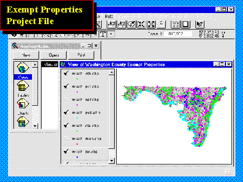
2.4 Exempt Properties Project File
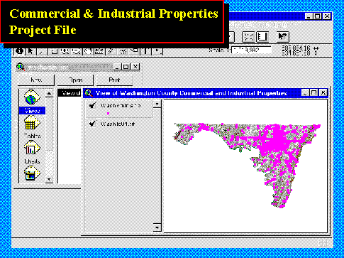
2.5 Commercial and Industrial Properties Project
File
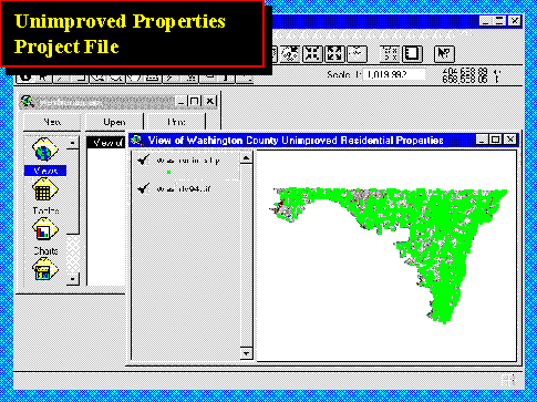
2.6 Unimproved Residential Properties Project
File
2.7 Overlay Project File
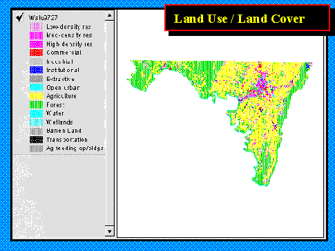
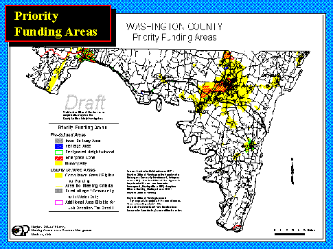
The second view contains the following thematic layers for the jurisdiction: Land Use/Land Cover - 1997 classification of land use/land cover (1:63,360) for the jurisdiction based on a level 2 U.S.G.S. classification scheme. Initially developed from high altitude aerial photography and satellite imagery the urban land use categories have been further refined using parcel data from the 1997 Edition of MdProperty View (see Figure 19). Priority Funding Areas - Current (as of production of the CD-ROM) boundaries for Priority Funding Areas as defined and developed based on the State's1997 Smart Growth legislation. Includes areas designated by each jurisdiction consistent with the criteria set forth in the legislation. Projects developed in these areas are eligible for special tax incentives and state funding (see Figure 20). MdProperty
View and the LUCA Program
In 1998, the Maryland Office of Planning developed another application for MdProperty View, which proved to be a great benefit to the State and local jurisdictions in preparing for the upcoming 2000 Census. In preparation for the 2000 Census, the U.S. Census Bureau has offered to the local governments across the country the opportunity to review the Bureau's address files before Census Day (April 1, 2000). Since these address files will be used to send out the Census questionnaires, it is crucial for an accurate Census that they be as up-to-date and as accurate as possible (see Figure 21). This LUCA (Local Update of Census Addresses) program was divided into two phases: LUCA 98 - which covered the city-style addresses in a local jurisdiction, and LUCA 99 - which covers the rural portions of jurisdictions in which mail is typically delivered to a post office box. The need for
a systematic approach
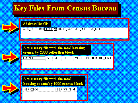
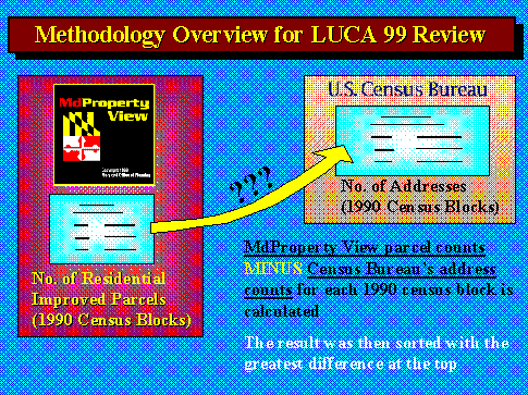
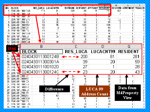
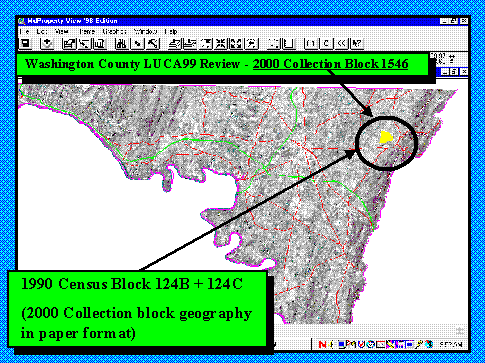
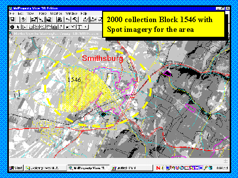
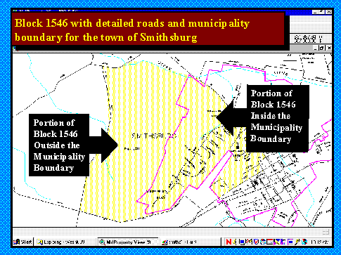
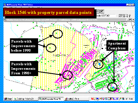
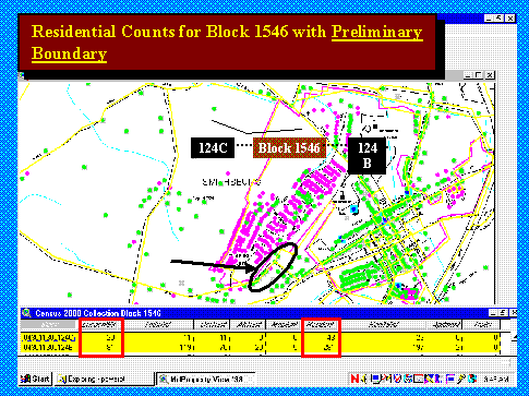
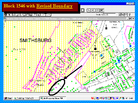
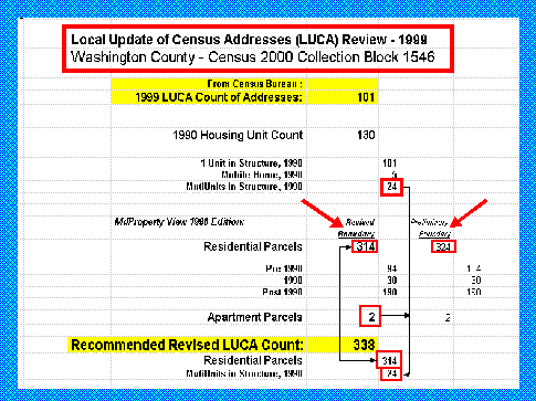
In Maryland, for the most part, local government is organized at the county level. As such, for several of the larger jurisdictions this means reviewing lists of a couple of hundred thousand addresses or more. On top of the sheer volume of addresses that must be reviewed for most of the local jurisdictions in Maryland, the Bureau requires that all corrections, additions, deletions, etc. be referenced to Census block. That is, the Bureau divided each local jurisdiction into thousands of "2000 collection blocks" and any changes made to the Bureau's list must have its 2000 collection block attached. This 2000 collection block geography is new and differs from the 1990 Census block geography that local jurisdictions have been using throughout this decade. Realizing the enormity of the task in reviewing the Census Bureau's address list files for most of the jurisdictions in Maryland, and given the relatively short review period (90 days for LUCA 98, 45 days for LUCA 99) offered by the Census Bureau; the Maryland Office of Planning has devised a methodology to efficiently target areas within a jurisdiction which would most likely yield additions/corrections to the Bureau's list. The methodology developed by the Maryland Office of Planning makes use of the computerized real property assessment file as organized by the MdProperty View system. The methodology involves following steps: Step 1. Derive summary counts by block The first step in this process is to intersect the residential parcels in the MdProperty View file with 1990 census block centroids (the Bureau did not make 2000 collection block geography easily available in a digital format). The result of this intersection is a count of residential parcels from the MdProperty View (with and without improvements) by 1990 census block. The U.S. Census Bureau, besides giving the local jurisdictions an address list file, also supplies two summary files with the total housing counts by 1990 census blocks as well as 2000 collection block geography (see Figure 22). The Maryland Office of Planning compares its list of the number of residential parcels by 1990 block generated from MdProperty View with the Bureau's list of the number of addresses by 1990 block. A difference (MdProperty View improved residential parcel counts minus U.S. Census Bureau's address counts) is calculated for each 1990 census block, and then sorted with those blocks with the greatest difference at the top (see Figure 23). The table in Figure 24 illustrates the results of the process just described for Washington County, Maryland. The 1990 census block 124B, in census tract 11300 had a count of 281 improved residential parcels in 1998, while the LUCA count from the Census Bureau indicates that there are only 81 addresses in this block. Thus, the MdProperty View file is indicating that there are 200 more housing units in this particular block than the U.S. Census Bureau has in its address file. (The LUCA count of 81 could also be compared with the 1990 census count of 119 for this block, another indication that the Bureau's address is short.) Step 2. Identify the 2000 collection block This area, block 124B in census tract 11300, is obviously a good candidate to investigate more closely, with a strong likelihood of yielding useful results. However, as mentioned previously, the Bureau requires all corrections/additions be submitted in 2000 collection block geography, not in 1990 census block geography. In this particular case, 1990 census block 124B must be identified by its 2000 collection block. There are several ways to do this, including using the paper maps that the Bureau provides of 2000 collection blocks, and/or using the actual address list which has a 1990 and 2000 collection block assigned to every address. By using this address list, and a series of queries in ArcView (an Esri GIS software), it was determined that census block 124B is part of 2000 collection block 1546. However, through these series of queries, it was also determined that 2000 collection block 1546 also consists of 1990 census block 124C in census tract 11300. This particular block (124C) has a residential parcel count of 43, or 23 more than the 20 addresses that the Census Bureau indicates is in this block. It can be initially concluded then, that collection block 1546, consisting of 1990 blocks 124B and 124C, needs additional 223 addresses (200 + 23) according to a comparison with MdProperty View. While the procedure so far has zeroed in on a particular 2000 collection block that most likely needs correction in the Bureau's list, there are a few things that need to be done in order to make sure of the exact number of new additions. Highlighting the data Figure 25 shows the location of 2000 collection block 1546 in Washington county, Maryland - which again is 1990 census block 124B and 124C. This is what is actually highlighted inside the circle, the Maryland Office of Planning not having 2000 collection block geography in digital format. Figure 26 by zooming down closer to the area, the block appears to be partly in the town of Smithsburg (magenta outline). Figure 27 by zooming in a little further, the street network begins to appear; most of which is in the town of Smithsburg. In Figure 28, the parcel points are turned on. The green dots represent improved residential parcels with improvements before 1990. The magenta dots are improved residential parcels where the improvements are from 1990 or later. It is more than likely that it is the parcels developed this decade (the magenta dots) which would be missing from the U.S. Census Bureau's address list. In the same view, note that there are two blue squares with a dot in the center. These represent apartment complexes, which are discussed later in this document. Figure 29 shows the area once again and a table of information for this area - block 124B and 124C. Note again that there are 324 residential parcels in these two blocks (43 + 281) compared to the 101 addresses listed in the LUCA file from the Census Bureau. But also note that there are two apartment units located within these two blocks. Where MdProperty View has a weakness in this application is in distinguishing the number of apartment units within an apartment building, since the assessment file usually has only the address of the building itself. This is something that one needs to be aware of when making the comparison between the number of improved residential parcels from MdProperty View and the number of addresses in the Bureau's list. (In our work with the Bureau's LUCA file for many jurisdictions in Maryland, we have found that the Bureau also falls short in many instances in listing individual units in apartment buildings). Note also that the table in FIGURE 5 contains data from the 1990 Census. This 1990 data indicates that there are 5 mobile units within the defined area. Mobile units can also be a problem in MdProperty View, depending upon how they are put in the assessor's file. In some cases, where the pads are individually owned, the addresses are listed separately, as with any single-family residential unit. However, when the pads are all owned by one person/company, then only one address will appear. Step 3. Refining the block boundaries Also shown in Figure 30 are the TIGER block boundaries in yellow. One, often time-consuming step, that needs to be taken is to ensure that these block boundaries precisely match actual boundaries as noted by the street network or other relevant features, and that the parcel points are on the correct side of the TIGER line boundary. This often requires creating an ArcView shapefile, which precisely defines the actual boundary of the 2000 collection block. In this particular case, it appears that the TIGER line boundary is a pretty good fit with the parcel boundaries and when it is redrawn, there is not much difference in the count of residential parcels contained in 2000 collection block 1546. Figure 31 presents a summary of what has been explained so far. For 2000 collection block 1546, the LUCA count of addresses total 101, which is actually 29 less that what was reported for the area in the 1990 Census (a clue that additions will need to be made.) In the 1990 Census it was reported that there were 101 single-family homes, and 24 units in apartments. Again, it is important to make sure that the apartment units are accounted for in the LUCA address list, since MdProperty View will also most likely not have a full listing of the individual units). When the shapefile is redrawn to better match actual boundaries there is a residential count of 314 improved parcels from MdProperty View, slightly less than the 324 residential improved parcels gotten from the preliminary block boundary intersection with the property parcels. The MdProperty View file also has a count of improved residential parcels by year of improvement. In this case, note that 190 houses were built after 1990. In all likelihood it is these units built this decade, which would most likely be missed in the LUCA address list. Note also the two apartment parcels in MdProperty View (but without a count of units in these parcels). Summarizing
the findings for the block
Figure 30 shows the refined shapefile, which produced the 314 single-family improved residential parcel count. If needed the actual property tax maps could be overlaid here, which in some cases proves useful in helping better define the intersection of the parcel points with the 1990 TIGER line boundaries. Generating
a list of addresses
A logical
approach
Conclusion
Acknowledgements:
Shahbaz Raza
|