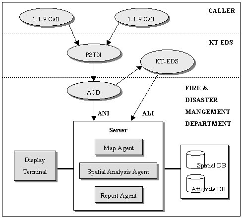
Fig. 1 1-1-9 Caller Location Information Process Flow.
Joo-Yeong
Shin, Kyoung-Yul Bae, Jae-Hu Jeong, Chang-Hahk Hahm, Joong-Hi Ryu
1-1-9
Caller Location Information System
The main purpose of 1-1-9 Caller Location Information System is to identify and display the precise location of emergency incidents such as natural or man-made fires, medical emergencies and accidents.[1] The state-of-the-art technologies such as ANI (Automatic Number Identification), ALI (Automatic Location Identification), GIS (Geographical Information System) and GPS (Global Positioning System) were applied and integrated in the system for efficient and effective location identification.
The system can also provide the shortest path to an incident location from a fire station or a fire engine. In case of a fire breakout in or near a building, the attribute information of the building, called a building attribute card, is displayed along with the map location. The system then matches the information with the fire situation and sends an alert to a responsible fire station by phone or fax in order to help promptly react to the problem. An attribute card includes the critical information of a premise such as building’s location, number of stories, floor plans, capacity, construction history, indoor fire detection and prevention facilities, etc.
The
area of Seoul, the capital city of Republic of Korea, as of the
end of 1998 is 605.52 ㎢, or 0.6% of the entire country. Han
river bisects the city into two parts, northern and southern
Seoul. Northern Seoul totals 297.97 ㎢ (49.2 %) while the
southern part is 307.55 ㎢ (50.8 %).
Seoul
has a population of 10,321,496 individuals and 3,458,511
households as of the end of 1998. This accounts for about a
quarter of the total national population. As for the proportion
of male to female, men (5,173,556) slightly outnumber women
(5,147,940).
Because
of the rapid development of the city in the modern history, the
structure and environment of the city is getting complicated and
there exist ever increasing possibilities of emergency
situations, either by natural or man-made disasters.
In
order to prevent and rescue the life and properties of the
citizens from fire and other disasters, the city’s Metropolitan
Fire Department has been developing ‘Emergency Dispatch and
Rescue Information System’ by utilizing Enterprise GIS
technology from 1996 to the present. The system is expected to
complete by the beginning of the year 2000.
The
EDRIS is an integrated system of call taking, emergency
dispatching and operational information management functions. It
consists of several subsystems such as ‘1-1-9 Caller Location
Information System’, ‘Vehicle(fire engine) Tracking System’,
‘Dispatching System’, and ‘Fire Facilities Management
System’. It can help identify the exact location of
emergency incident and can support rescue dispatch through
intelligent message broadcasting and the shortest path
generation.
One
of the critical success factors of the system, as most mission
critical systems, is its efficiency. The system must allow fast
search of information from massive textual and geographical data
and execute multiple queries and reports at almost real time. The
design of a consolidated database, which carries both operational
information and geographical information, and the functional
architecture, supporting for fast retrieval and association of
the textual and graphical information, were the challenging
design issues. After careful and intensive benchmarking of
various commercial GIS packages, Esri’s enterprise GIS solution
was selected to resolve those challenges.
SDE
3.0.2 and ARC/INFO 7.2.1 on UNIX platform became the fundamental
GIS softwares for the system. ORACLE was selected as the RDBMS
for its seamless integration with SDE. Visual C++, for its
flexibility and integrated development environment, was used for
developing client application on Windows NT.
3.1 Database
For ‘1-1-9 Caller Location Information System’, the project
team needed to construct disaster related database including both
spatial and attribute data. Spatial database should contain
both general supporting information and operational disaster
related information. General information includes roads,
buildings, geocode map, administration boundaries, traffic
information, and meteorological information. Disaster
related information includes hydrants, fire fighting facilities,
hazardous material and facilities information, fire station
location, hospital information, and disaster controlling unit.
For detail information about spatial database, please refer to
the following table.
|
Data |
Description |
| General
Information |
Road |
Road
name, number of lanes, link to other road(s) |
| Main
Building |
Detail
information of large and tall buildings specified by a
regulation |
|
Geo Code Map |
Geo
code with address |
|
| Administration
Boundaries |
Administrative
jurisdiction boundary |
|
| Traffic
Information |
Location
of traffic accident, under construction, etc. |
|
| Meteorological
information |
Snow,
rain, mist, etc. |
|
| Disaster
Related Information |
Fire
Facilities |
Fire
hydrant, hydrant location, etc. |
| Hazardous
Facilities |
Explosive
or volatile facilities |
|
| Fire
station Location |
Fire
station, ward office |
|
| Hospital
Information |
Hospital
location, capacity and specialties |
|
Disaster
Controlling Unit |
Main
body who control the sector |
|
| GPS |
Vehicle(fire
engine) location, type of vehicle (on-line) information |
Table 1. Description of Spatial Database
3.2 1-1-9 Caller Location
Information System
This subsystem provides operators with various convenient query
mechanism for location information and displays context sensitive
features for rescue unit dispatch to help clear the problem as
fast and efficient as possible.
ANI
and ALI modules are integrated in the call taking process, as
shown in the following diagram. When emergency operator picks up
a 1-1-9 call, he or she can almost simultaneously get a caller
location information, neighboring information, a shortest path
and an estimated time to destination.
Fig. 1 1-1-9 Caller
Location Information Process Flow.
q
ANI : Automatic identification of the caller’s phone number
q
ALI : Automatic identification of the address matched with the
phone number
q
Map Agent : Agent handling the map display of the location with
appropriate zoom scale, pan relocation and symbol(s)
q
Report Agent : Agent providing the displayed information with a
pre-specified report format
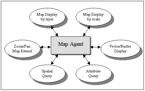
Fig.2 Main Functions of
Map Agent.
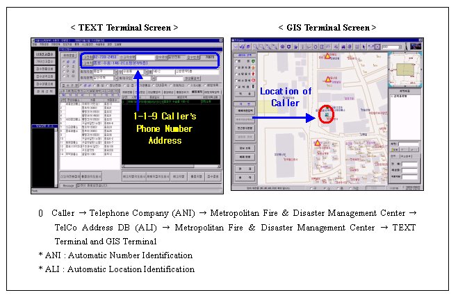
Fig.3 Identifying 1-1-9
caller’s phone number and displaying map location
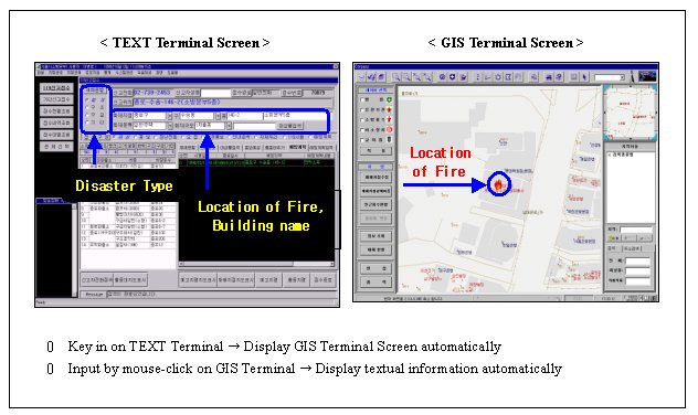
Fig.4 Identifying and
Displaying Disaster Location
3.3 Vehicle tracking System
This
subsystem provides the functions of fire engine operation
management system in case of emergency dispatching. GPS
technology enables to monitor fire engines’ movement in on-line
mode. ‘GPS Agent’ receives the location information of
fire engines and feeds this information to Map Agent for display.
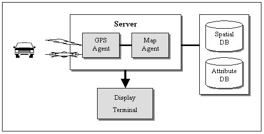
Fig. 5 Vehicle Tracking
System Diagram.
3.4 Message Delivery System
(Information Support System)
Information Support System maintains various informations related
to disasters and can be operated with Message Delivery System.
For example, in case of emergency, this subsystem can verify and
display the up-to-date information, and provide essential
information for the preparation of message delivery plan. It
also performs the function to support decision-making process for
message delivery.
q
Road, building and disaster facilities information display
q
Disaster size and type display
q
Providing the regional disaster facilities information
q
Disaster response plan and display
q
Message delivery by fire station
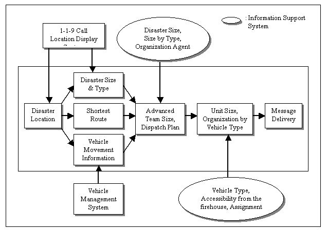
Fig. 6 Message Delivery
System Diagram.
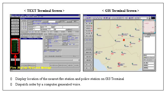
Fig. 7 Dispatch Order
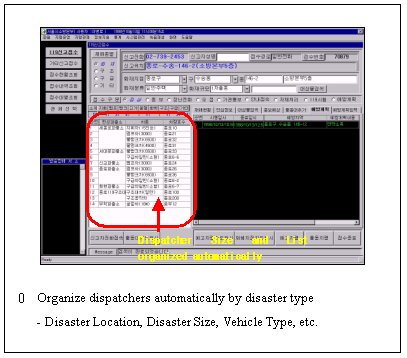
Fig. 8 Automatic
Dispatcher Organization
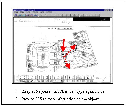
Fig. 9 Disaster Response
Plan Chart
3.5 Fire Facilities Management System
(Map Editing System)
Fire Facilities Management System has the goal in performing the
function of disaster management system by maintaining the fire
facilities consistently. This system provides information in the
aspects of previous FM and future plan by displaying the
facilities information with spatial and attribute information. It
can also set up plans to cope with disasters using the
information of appropriate resources.
Spatial and attribute data of Fire Facilities may be changeable. Therefore, the procedure to create and build data as well as the editing function such as correction and addition for these data are important. It is required to verify data for optimization or errors.
During this project, the project team found some difficulties of
finding 1-1-9 Call Location Information because of 1)
accuracy problem on parcel based map, 2) discrepancy during
integration of various source information, and 3) text
annotation overlapping. In order to improve efficiency of
this system, the further research must be focused on: 1)
Moving vehicle tracking system by using GPS; 2) Rescue
vehicle dispatch arrangement by analyzing temporal disaster
occurrence; 3) Re-distributing fire hydrant after its
position analysis; 4) Integration with GIS-T or ITS and
improvement of dispatching functions in conjunction with
transportation environment.
Special thanks will be addressed to
all of Seoul Metropolitan Fire & Disaster Management
Department who allowed unrestricted access to the overall system
implementation. The support of Inha University Foundation and
President Dr. Chang-Soon Yim of Inha Technical College are
gratefully acknowledged.
146-2,
Soosong-Dong, Chongro-gu
Seoul, 110-142,
Korea
Telephone :
82-2-735-0119
Fax :
82-2-734-5243
E-mail :
chief@fire.seoul.kr
Kyoung-Yul Bae,
Ph.D./ Chief Information Officer
Seoul Metropolitan
Government
31, 1-Ga
Taepyung-Ro, Chung-Gu
Seoul, 100-744,
Korea
Telephone :
82-2-3707-9105~6
Fax :
82-2-3707-9189
E-mail :
jbae@www.metro.seoul.kr
Seoul Metropolitan
Fire & Disaster Management Department
146-2,
Soosong-Dong, Chongro-gu
Seoul, 110-142,
Korea
Telephone :
82-2-722-1119
Fax :
82-2-737-0723
E-mail :
jhjeong@fire.seoul.kr
Chang-Hahk
Hahm, Ph.D.,P.E./Associate Prof.
Inha Technical
College
253,
Yonghyun-Dong, Nam-Gu
Inchon, 402-752,
Korea
Telephone :
82-32-870-2241
Fax :
82-32-870-2511
E-mail : chhahm@true.inhatc.ac.kr
CADLAND, Inc.
Suite#805,
Diplomatic Center,
1376-1,
Seocho2-Dong, Seocho-Gu,
Seoul, 137-072,
Korea
Telephone :
82-2-571-1101
Fax :
82-2-571-1311
E-mail :
jhryu@cadland.co.kr
[1] In fact, the system identifies the caller’s location rather than the incident location, but the statistics show that, in more than 95% of the reported cases, the location of an emergency caller is practically identical to the location of the incident.