A Regional Approach to Crime Mapping and the Web
Although crime statistics, and in some cases static maps, have been available to the public via the Web for several years, the 35 participating agencies of the Automated Regional Justice Information System (ARJIS) recognize the effectiveness of the Web to disseminate crime information through an interactive mapping application. The development of such an application displaying crimes and arrests from a regional repository, and Calls for Service from individual CAD systems in near real-time is becoming a reality for San Diego County. This paper will discuss the processes associated with developing an interactive crime mapping application available on the Web.
INTRODUCTION
Unlike crime statistics, public access to crime maps has been limited. In many cases these maps were reserved for in-house use due, in part, to technological limitations, as well as a concern for victim privacy. With the advent of the Internet and its wide spread availability in recent years, it is now feasible to post relevant public safety information on departmental Web pages augmenting traditional means of reporting (e.g. local newspaper and crime briefings).
Although the past year has resulted in a significant increase in the number of law enforcement dedicated Web sites, only a limited number of departments actively make crime maps available to the public through this rapidly growing medium. Even fewer departments have been willing or able to make the technological or philosophical leap to provide interactive crime mapping to the public. Not only is the San Diego Police Department (SDPD) and the Automated Regional Justice Information System (ARJIS) collaborating on the development of a regional interactive mapping application for public access, but an application that meets near real time requirements.
WHAT is ARJIS?
The Automated Regional Justice Information System (ARJIS), established in the 1970s as a Joint Powers Agency (JPA) under the California Government Code, currently consists of 35 member agencies (see Appendix A). ARJIS, through the San Diego Data Processing Corporation (SDDPC), provides and maintains a complex regional law enforcement computer system, which includes information on crime cases, arrests, citations, field interviews, traffic accidents, fraudulent documents, and stolen property. ARJIS is used for criminal investigations and statistical information. Additionally, the jurisdictions utilize a crime analysis component available through a data transfer to the Crime Analysis Statistical System (CASS).
ARJIS is comprised of over 300 computer programs and sub-modules running on a central mainframe. This system services a network of over 659 computer terminals and printers throughout the 4,265 square miles of San Diego County. There are over 7,000 authorized users generating approximately 27,000 update and inquiry transactions daily. The system is operational twenty-three hours per day, seven days a week.
WHY the ARJIS INTERACTIVE MAPPING APPLICATION (IMA)?
Of the crime mapping Web sites available to the public, the majority are agency specific; maps published by the San Diego Police Department (SDPD) for the past three years are no exception. Although there are a number of reasons for this, including, but not limited to, antiquated technology, inaccessible data, and lack of funding, there are a number of benefits to developing a regional application over one that is agency specific. First and foremost, the cost of development is spread over several agencies rather than absorbed by one. Moreover, the initial startup costs of a Client/Server deployment is significantly greater than a centralized (mainframe) system, making the development of such applications cost prohibitive for most departments(1).
With of the availability of incident, person, vehicle, location and property information in the ARJIS regional data repository, it was quickly determined that the Web would be an ideal vehicle to present crime data in an easy to use, widely accessible medium while serving the immediate needs of the public. Similarly with the move towards community oriented policing, any law enforcement personnel armed with a laptop computer and wireless modem may facilitate community problem solving through neighborhood and house meetings by demonstrating the an interactive mapping application. Through these forums the public will become more aware of current and new public safety resources.
Although the initial goal in developing ARJIS IMA was to provide the public access to crime mapping, SDPD and ARJIS acknowledged the potential uses through a departmental Intranet setting, as well as augmenting sophisticated spatial analyses already provided by crime analysis units. In fact, departments of all sizes can easily deploy GIS tools to managers or other non-traditional users quickly and inexpensively. Clearly this benefits all agencies in a time when budgets for software, hardware, and training are spread thin across departments. Additionally, jurisdictions, as is the case with San Diego County, may not immediately have access to data from other agencies within the region. In other words, San Diego only sees San Diego’s data, National City sees their own, and so on. Developing a standardized, regional application not only reaches the largest audience, both public and law enforcement, but it ensures a consistent representation of data between jurisdictions.
Secondly, crime generally does not stop at agency borders. Important series information may be lost because underlying crime data is not available outside the jurisdictional boundaries. Although this point may be less obvious to the casual user, a member of the law enforcement community using such an application will recognize its significance.
ARJIS IMA OVERVIEW
The Internet is widely accessible to people of all ages, both at home and in public facilities, including libraries and Internet cafés. Public access to ARJIS IMA requires nothing more than access to the Internet and one of the recommended Web browsers(2). In the future access to an Intranet version of ARJIS IMA will be controlled by a user logon and password.
Although San Diego PD originally provided static maps and crime listings for the previous month, public demand precipitated weekly updates illustrating the most recent 30 days of information. However, the main complaint still has been timeliness of information. Several focus groups consisting of members of San Diego Retired Senior Volunteer Patrol and citizens actively participating in organizations including Safe Streets Now and the San Diego Organizing Project expressed the need for information beyond what is already provided by San Diego PD. Therefore, one of the main objectives of this project is to deliver accurate, timely and consistently formatted data which is easy to understand and publicly accessible. To achieve this, ARJIS IMA will operate in "near-real time", which is defined as:
Immediately sending a call, closed in the SDPD Computer Aided Dispatch system, to a designated server at SDDPC, which will load into ARJIS IMA within 15 minutes of incident reception and a single load of ARJIS incident data within 24 hours of entry into the ARJIS mainframe system.
ARJIS IMA COMPONENTS
System Architecture
ARJIS IMA is a multi-tiered, Client/Server system implemented using standard, commercial "off-the-shelf" (COTS) vendor hardware and software; however, custom programming is still necessary to capture and process incident data and provide various application functionality, including Pan, Zoom and Identify (see Application Functions).
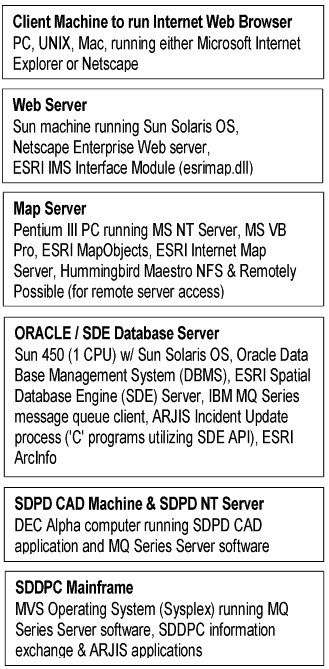
ARJIS IMA integrates several technologies including application and development software from Esri (MapObjects, Internet Map Server, Spatial Database Engine, ArcInfo), Visual Basic programming tools, Internet Web technology (Java, HTML) and IBM MQ Series message queue programming. Custom 'C' programming is used to integrate the various technologies and the data. Several operating systems are utilized including, Microsoft NT for the mapping server, Sun Solaris for the Database and Web servers. The Internet Web server computer will run Netscape Enterprise Server and the Database server will run the ORACLE Data Base Management system.
The primary ARJIS IMA components are shown in the figure below:

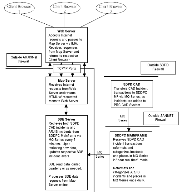
These elements communicate over the Internet, ARJISNet, SANNET and the SDPD Local Area Network using standard TCP/IP protocol. The configuration is shown below:
Security
As stated earlier, ARJIS IMA currently has no special passwords or security requirements. The data will be implemented with READ ONLY access while programs will be defined with EXECUTE access. WRITE access is assigned as needed, as is the case with the Map Server program requiring permission to write the map images to the appropriate Web Server directory.
Incident Data
Although ARJIS IMA is designed to accept and store data from multiple sources, it currently receives data from the SDPD Computer Aided Dispatch (CAD) system and the ARJIS mainframe system. Data from ARJIS are representative of incidents occurring throughout San Diego County, whereas data from SDPD CAD include calls for service occurring within the City of San Diego. All incidents, regardless of the source, are collected on the SDDPC mainframe via the MQ Series server-based information exchange (3). Once received, the standard format data is processed and reformatted using another standard file layout devised for ARJIS IMA. Subsequently, the newly processed and formatted incident data are transferred to the SDE Database Server, a single Oracle database, enabling incident selections under the following map view categories:
Crime & Disorder |
Vehicle & Traffic |
Enforcement Arrests & Citations |
| Murder | Auto Theft | Truancy |
| Sexual Assault | Auto Recovery | Curfew |
| Robbery | Auto Burglary | Narcotics |
| Assault | Accidents | Prostitution |
| Shooting at Dwelling | Citations | Drunk in Public |
| Vandalism | Driving under the Influence * | |
| Arson | ||
| Residential Burglary | ||
| Commercial Burglary | ||
| Disturbing the Peace * | * Represents SDPD CAD data |
|
ARJIS IMA provides for regular additions of new, modification of existing, and purges of old incident data. Essentially, the amount of incident data available for mapping is equivalent to the most recent 60 days (worth of data). A custom 'C' program, accessed through the SDE Application Programming Interface (API), will run weekly on the SDE Database server to purge incidents based upon transaction date. A purge report is automatically distributed to key personnel from ARJIS and SDPD for review.
Incident data is validated prior to the load into the SDE Database server. For example, valid XY coordinates or location cross-reference are determined prior to acceptance of the record. There may be instances of records originally containing limited information requiring updates after the purge cycle, in which case the record becomes invalid since it can neither be added nor updated. Invalid records meeting certain criteria are then included in a daily error report automatically distributed to key personnel from ARJIS and SDPD.
Map Features
The map features data includes all relevant geographic layers, excluding incident data. The majority of map data is either supplied by, or created from data maintained by the San Diego Geographic Information Source (SanGIS). The map data is provided in Esri shape file format and is loaded through a manually initiated utility program available in SDE. This process is used for initial map layer loads and subsequent map layer refreshes. Additionally, ARJIS IMA processing does not edit or validate the map layer data. The current map feature layers are as follows:
Geographic Area |
Geographic Layer |
| San Diego County | Freeways |
| Major Roads | |
| Streets | |
| Schools | |
| Rivers | |
| Lakes | |
| Park Boundaries | |
| City Boundaries | |
| Supervisorial Boundaries | |
| Communities / Neighborhoods | |
| City of San Diego | Council Districts |
| Police Facilities |
All of the listed layers are stored in SDE, however a single shape file, the SanGIS County wide street layer, resides on the Map Server and is used in conjunction with MapObjects geocoding.
Application Functions
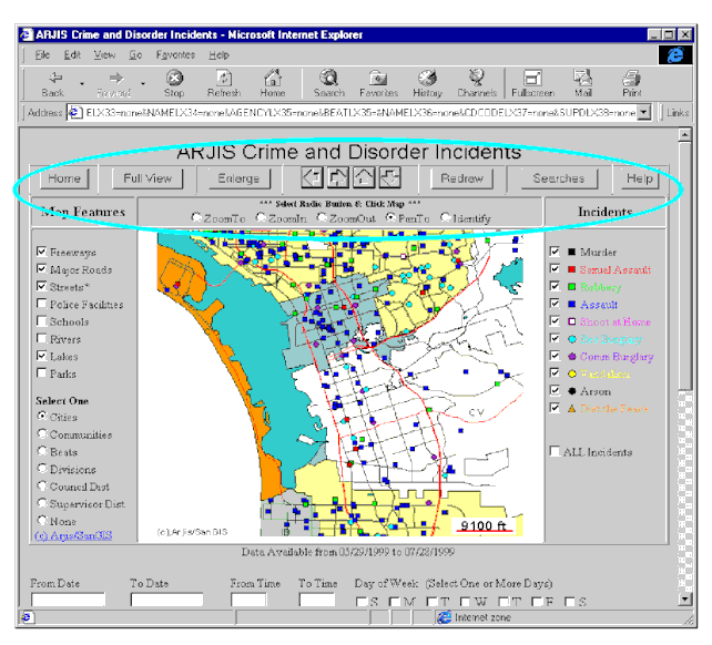
The interactive mapping screen is the primary user interface for ARJIS IMA. It is generated using a Microsoft Visual Basic 6.0 program running on the Map Server and provides several basic functions, including:
ARJIS IMA utilizes two Esri products, MapObjects 2.0 and Internet Map Server (IMS) 2.0, to generate maps and interface with the Internet Web Server. The program creates HTML, Javascript and compressed 'GIF' files and subsequently transfers them to the Web Server via the IMS extension.
The map, actually a 'GIF' source file, is temporarily stored in a file directory on the Map Server. The 'GIF' file is available for a maximum of five minutes, which necessitates printing the map through the Web browser Print command within five minutes of receiving the image to ensure availability. While this time constraint may be modified, it does present a problem for users attempting to "bookmark" the interactive mapping screen.
ARJIS IMA provides functionality to control geographic layer selection and map display. Users make both map features and incidents active or inactive simply by clicking on check boxes or radio buttons in the Left and Right Legends. The radio button geographic layers, unlike the check box geographic layers, are mutually exclusive. In other words, users may only select and display one of the radio button geographic layers (e.g. Cities, Communities, Beats, Divisions, Council Districts, Supervisorial Districts) at a time.
As stated earlier, ARJIS IMA provides the most recent 60 days worth of incidents at any given time. The default display of data is 60 days, however, the option to select a date range (within the 60 days), the day of week, and a time range is provided. Although any combination of date, time, day of week may be determined by the user, the actual search criteria is executed in conjunction with a geographic search or other function such as Pan, Zoom, and Redraw.
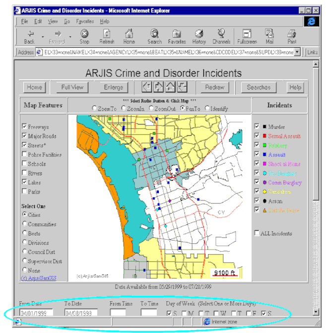
Several geographic search options have been included in ARJIS IMA providing users control over the map extent. In addition to the search options consistent with the list of radio button geographic layers, users have access to an address-matching (geocoding) tool. This address-matching search option enables has been developed to handle addresses, as well as intersections. Like any other county, San Diego County, has its share of duplicate addresses. When ARJIS IMA encounters duplicate addresses as a result of users input, a selection list box will automatically display the appropriate candidates. For example:
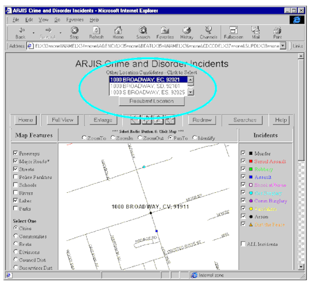
This is typically the case when users fail to enter a City or Zip code. In the event that an address or intersection is not found, a separate window displays the message No Match. It is also important to note that the address-matching option does not enable users to search for incidents occurring at a specific address, rather it merely zooms the user to the desired location.
ARJIS IMA provides several functions to manipulate the map display, including Pan and Zoom tools (radio buttons), County View, Redraw and Navigation function buttons located at the top of the interactive mapping screen. These tools or function buttons will either determine the map scale, the map extent within the County of San Diego, or simply refresh the image while maintaining the current map extent and scale.
ARJIS IMA provides an Identify function enabling users display summary incident information in a separate Web browser. The application internally establishes a square of pre-determine area around the point on the map on which the user clicks, and displays summary information about all incidents in that area. As a result, multiple incidents may be selected, however, only information for the active (checked) incident layers is displayed. The public access version, shown below, includes date, time, day of week and location attributes. The location information, in particular, is only displayed to the 100-block for public access, a practice consistent with incident reporting in local newspapers and on the San Diego PD Web site.
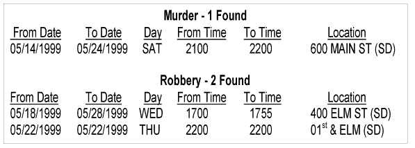
In the instances when multiple incident types (e.g. Murder, Robbery, Assault, etc) are selected, the display will separate the incidents into appropriate groupings.
Finally, ARJIS IMA provides users with the ability to print an enlargement of the current map display. This feature, available by clicking the Enlarge function button, enables users to display an enlarged map with a legend and title in a separate Web browser window. The title, created by user input into a text box, is optional, whereas the date range (sub-title) defaults to the by the date range parameters identified by the user from the interactive mapping screen.
TESTING & TRAINING
ARJIS IMA system testing is currently underway. The system testing, to be performed by SDDPC and select SDPD / ARJIS personnel, will verify the operation of all functions, including:
Customer acceptance testing will actually involve application testing and a data audit. The application testing, to be conducted by various ARJIS participants and San Diego PD Crime Analysis Unit staff, will include functional and integrity acceptance; whereas the data audit is designed to verify the proper transfer and update of data and that all application functions return the anticipated results.
Key personnel from the several member agencies will be invited to a hands-on training session to learn about ARJIS IMA functionality.
ARJIS IMA ENHANCEMENTS
ARJIS IMA is in no way complete and is designed to be "open" so that additional functionality and layers may be added later. As the public access version of IMA evolves, San Diego PD and ARJIS are discussing how to provide the law enforcement only, or Intranet version of IMA. Nevertheless, the following is a list, albeit incomplete, of proposed changes for the public access ARJIS IMA:
APPENDIX A
ARJIS Member Agencies
- Carlsbad Police Department (CBPD)
- Chula Vista Police Department (CVPD)
- Coronado Police Department (COPD)
- El Cajon Police Department (ECPD)
- Escondido Police Department (ESPD)
- La Mesa Police Department (LMPD)
- National City Police Department (NCPD)
- San Diego Police Department (SDPD)
- San Diego Sheriff’s Department (SDSO) *
- Bureau of Alcohol, Tobacco, and Firearms
- California Department of Insurance
- California Department of Justice
- California Department of Parks and Recreation
- Donovan Correctional Facility
- Federal Bureau of Investigation
- Internal Revenue Service
- Naval Investigative Service
- San Diego City Attorney
- San Diego City Schools
- San Diego State University Police
- San Diego County District Attorney
- San Diego County Marshals Office
- San Diego County Probation Department
- United States Attorney
- United States Customs Service
- United States Forest Service
- United States Marshals Service
- United States Postal Inspection Service
- United States Pretrial
- University of California San Diego
* San Diego Sheriff’s Department Contract Cities
|
|
AUTHORS
| Deena Bowman-Jamieson | Information Systems Analyst San Diego PD Crime Analysis Unit, 1401 Broadway MS #739, San Diego, CA 92101 Phone: (619) 531-2413 Fax: (619) 531-2408 email: zgb@sdpdms.sannet.gov |
| Pat Drummy | Supervising Crime Analyst San Diego PD Crime Analysis Unit, 1401 Broadway MS #739, San Diego, CA 92101 Phone: (619) 531-2413 Fax: (619) 531-2408 email: phd@sdpdms.sannet.gov |
| Pamela Scanlon | ARJIS Program Manager SDDPC, 5975 Santa Fe St MS# RC-411, San Diego, CA 92109 email: plb@dpc.sannet.gov |
(2) The recommended Web browsers are Netscape Navigator and Microsoft Internet Explorer (version 3.0 and higher)
(3) A middleware product from IBM enabling the integration of desktop and legacy mainframe system applications