


AGIS - An Agricultural GIS for South Africa
M.E. Rust*1, R.O. de Munnik*1, H. Lindeman*2 & J Weir-Smith*2
|
|
|
*1
Agricultural Research Council – Institute for Soil, Climate and Water, Private Bag X79, Pretoria, 0001, South Africa.*2 National Department of Agriculture, Private Bag X250, Pretoria, 0001, South Africa.Abstract. Timely availability of reliable geo-referenced soil, climate and water data and information, integrated with infra structural, socio-economic, cultural and environmental factors of production, are essential in order to exercise the best option in using these resources to achieve sustainable levels of production and development.
Between the Agricultural role players and other spatial information providers in South Africa, there is a wealth of resource information. However, this information is seldom readily accessible.
This paper focuses on how GIS technology was deployed to address this huge gap in the South African Agricultural community. The project with the objectives to establish a holistic and user-friendly information model using GIS technology and to facilitate the storage, analysis and interpretation of geo-referenced information, on all levels for Agriculture in South Africa will be discussed.
Introduction
Land degradation and land and water scarcity are rapidly increasing, undermining the capacity of the resource base to sustain food production at required levels. A better use of the land and water resources and an understanding of the components (soils, climate, vegetation, topography), their relation, interdependency and interactions, are essential to achieve sustainable production of food and the conservation of these resources for generations to come.
Timely availability of reliable geo-referenced land, climate, plant nutrients, production and water information, integrated with infra-structural and socio-economic factors, are essential for stakeholders, policy makers and land users to exercise the best option in using these resources to achieve sustainable levels of food production and development in an increasingly complex environment.
Between the South African Agricultural role players (National Department of Agriculture, Provincial Departments of Agriculture, the Agricultural Research Council (ARC) and other spatial information providers, there is a wealth of information. However, this information is not readily accessible. This could be due to various reasons including:
|
|
|
|
|
|
|
|
|
|
|
The need for and access to spatial information in South Africa, to use in decision making and development planning is a topical issue and inevitably leads to discussions on uncoordinated effort, a lack of funding and expertise and the unavailability of good quality, standardised data.
GIS-based information systems on land and water is world-wide becoming an integral component of institutionalised programmes for integrated natural resource planning, management, conservation and agricultural development. It was realised that a well co-ordinated, integrated and holistic model by means of Geographic Information System (GIS) technology could facilitate the storage, analysis and interpretation of geo-referenced information. This was the only option to overcome the unavailability or non-access to data and information.
The imbalance, which exists between the information produced, and the national capacity to use this information, inevitably dictates geo-information scientists to carefully adhere to user requirements such as:
|
|
|
|
|
The Agricultural role players in South have positioned themselves to address these needs. A long-term goal was set to structure a corporate GIS for Agriculture (AGIS task team, 1998) on a national and provincial level. Geographic data and information initiatives will be integrated as provincial, regional and national data sets, models and decision support systems in order to ensure effective decision making.
Project products
The project will result in an Agricultural Information System for South Africa (AGIS), that will support effective policy formulation and decision-making at all levels.
The process involved in executing such an endeavor can be summarised in Figure 1.
Figure 1: Schematic presentation of the information system
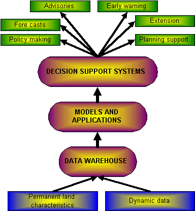
During the execution of the project, several databases or information systems will be developed and included in AGIS. Users will be able to view or extracted data/information over the Internet. Some of these core data sets are:
A meta-database, which will be populated as the various spatial databases are added to the system. The meta-data base will supply information on what data is available, the definition of each data element, whether data meets specific needs, how to acquire it, and how to extract it for local use. The selected data base applies the content standard for meta-data of the United States Federal Geographic Data Committee (FDGC) and links with the National Spatial Data Discovery Facility (NSIF staff, 1999).
An orientation database that will contain national and provincial boundaries; rural land parcels linked to the particular owner; towns and settlements; roads; railways and scanned 1:50 000 cadastral maps.
A topography database containing digital elevation data with applications that can be invoked to produce user defined products, such as slope and terrain morphological maps.
An Internet based climate information system that can be accessed through an interface, which allow the user to define a query for a particular time series. The query will then be submitted to a central processing unit for interpolation and the resultant map will be forwarded to the client
A soil data base and information system containing soil information, such as land types (Land Type Survey Staff, 1972-1999), soil profiles (with extensive soil profile descriptive and analytical as well as mineralogical data for input in models and various products as needed) and deducted products, such as generalised soil patterns; soil acidity; soil fertility status such as: Soil organic matter content, Magnesium, Nitrogen, pH, Potassium, Phosphate, Sodium, Zinc as well as soil potential.
Being a fairly large country, animal husbandry is of prime importance and a major thrust is in the process of development to setup animal decision support systems. The first database that will be developed is an animal disease data base and information system. It will be designed to supply decision makers with valuable information on disease outbreak, control, statistics as well as integrating the Web for disease identification and treatment.
Other auxiliary data such as geology, hydrology, vegetation and land cover will be bought from other data custodians and integrated in the system as needed.
Ultimately these databases and information systems will be utilised through the process of value addition to develop Decision Support Systems for Agriculture. Decision support systems allowing for the integration of all factors (natural resource, financial and socio-economic) influencing an event, is the ultimate goal. Decision support systems for crop suitability, animal production and agricultural statistics, forms the first products of the envisaged system for the next two years. It is exactly at this point that we need to converge GIS in the Information Technology environment in order to leverage the potential created by the Internet. Access to data, applications, models and the most important access to easy to use decision support tools is the key word in the development of the system.
Project administrative environment
A coordinating body coordinates the development of AGIS. Training, capacity building and data/information dissemination is an integral part of the project.
The following structure for the operation of AGIS is proposed:
Figure 2: Operational environment of the project.
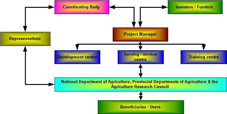
The role of each group is summarised as follows:
|
|
|
|
|
|
|
|
|
|
|
|
|
|
|
|
|
|
|
|
|
|
|
|
|
|
|
|
|
|
|
|
|
|
|
|
|
|
|
|
|
|
|
|
|
|
|
|
|
|
|
|
|
|
|
|
|
|
|
|
|
|
|
|
|
|
|
|
|
Project operational environment
The project is a real challenge in terms of converging GIS into the IT environment. Access will be possible by registering as so-called "thick and thin" users. Thin users can view data currently available on AGIS through the World Wide Web (www.nda.agric.za/agismaps/index.htm). A task team is currently investigating means to ensure the sustainability of the system. Access is currently guided through three atlases namely an Orientation, Natural Resources and Images atlas. MapCafe Java applications within a Netscape or Microsoft Explorer browser facilitate the access. Data is transmitted trough the web in a JPEG format. The MapCafe application is structured to switch layers on/off , zoom in/out, identify and search the layers in the view.
Figure 3: AGIS Website
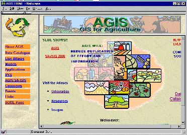
A Microsoft NT webserver maintains the webpages (www.nda.agric.za).
Future developments includes the implementation of ARC IMS 3, which will enable the downloading of limited data and will allow for more flexibility with manipulation of data across the web.
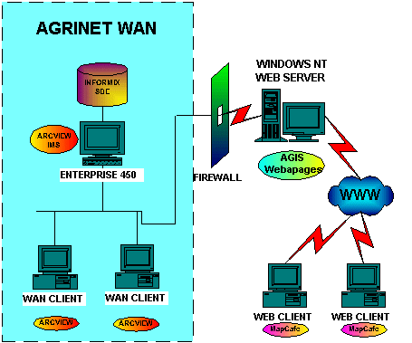
Thick users will be allowed access to AGIS by a licensing agreement scheme. ArcExplorer or ArcView will be deployed to connect to the central SDE server and after supplying a username and password allowed viewing of the SDE layers within the SDE/Informix server. All SDE layers can be viewed and queried in SDE format, but cannot download to shape format with the ArcExplorer application. ArcView currently facilitate the download of SDE data into a shape format, which users can use in desired GIS applications.
The SDE layers were converted from shape files to SDE in a decimal degree coordinate system. All attribute information for the different layers where also converted to the Informix environment from Arc/Info, DBase and Access.
A port through a firewall was established to communicate with the Enterprise 450, Solaris 2.6 Unix server, on which ArcView 3.1 and Internet Map Server extension is running.
Figure 4: Server & Client environment.
Functionality
It is envisaged that a complete set of tools must be provided to the agricultural community. These tools includes (Kraak Menno-Jan, 1999):
Basic display
Map display needs tools that allow the user to pan, zoom, scale, and transforms and rotate.
Navigation and orientation
This involves the keys to a map. At any time, the user should be able to know where the view is located and what the symbols mean.
Data query
During any phase of access the user should have access to the spatial database to query the data. The questions should not necessarily be limited to simple what, where or when queries.
Multiscale capability
Combining different datasets in an exploratory environment, in order to answer what if scenarios must be embedded in the system.
Multiple dynamically linked views
Such tools combine multimedia and different types of data from different sources, in models designed to solve complex issues by means of multi-criteria analysis.
Conclusion
The operational objective of AGIS is to increase the quality, efficiency and accountability of the decision-making processes. This will be done by providing good quality information, through applications that systematically use environmental and socio-economic information, to the benefit of the Agricultural community in Southern Africa. GIS technology is set to have a major effect on natural resource characterisation, quantification, agricultural land and farming systems management, natural resource monitoring and sustainable agricultural development, without jeopardising the resiliency of the natural resources.
Once fully operational, AGIS will contribute to the production and dissemination of information, that must lead to the creation of a literate citizenry empowered to improve their well being.
References
AGIS task team. 1998. An Agricultural GIS for Southern Africa. A Project proposal developed for the National Department of Agriculture. Directorate: Information and Efficiency enhancement, Pretoria.
KRAAK MENNO-JAN. 1999. Modernised map-making in GEOEurope, Issue 6, June 1999. Page 20-21.
Land Type Survey staff. 1972-1999. Mem. Agric. Nat. Resources. Institute for Soil, Climate and Water, Pretoria. South Africa.
NSIF staff.1999. National Spatial Information framework. Department of Land Affairs, Pretoria, South Africa.
World Bank. 1999. Environmental information systems in Sub-Saharan Africa: from innovation to management in Findings, February (128). Knowledge and Learning centre Africa Region, World Bank, Washington DC.
Author Information
| Lizette Rust & Rudolf de Munnik |
| Agricultural Research Council – Institute for Soil, Climate and Water |
| Private Bag X79 |
| Pretoria |
| 0001 |
| South Africa. |
| phone: 27 12 310 2500 |
| fax: 27 12 323 1157 |
| email: l_rust@igkw2.aric.za |
| email: r_demun@igkw2.agric.za |
| Hein Lindeman & Jimmy Weir-Smith |
| National Department of Agriculture |
| Private Bag X250 |
| Pretoria |
| 0001 |
| South Africa |
| phone: 27 12 319 7548 & 27 12 319 6197 |
| fax: 27 12 329 5938 & 27 12 319 6349 |