|
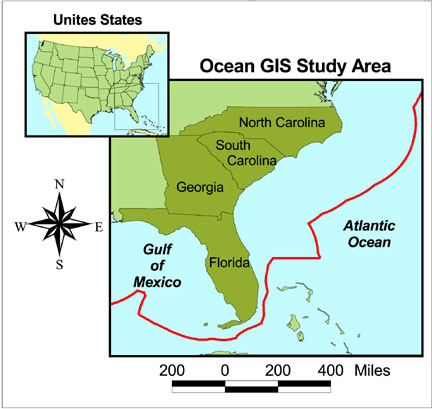
| Figure 1. The Ocean Planning and Governance GIS study area extends from the states' coastal zone out to the Exclusive Economic Zone. |
In the U.S., the policies regulating our ocean resources have historically been developed as single-purpose regimes. To facilitate a more integrated, comprehensive ocean management strategy, the Coastal Services Center (CSC) of the National Oceanic and Atmospheric Administration has developed a MapObjects™ -driven web-based regional ocean governance geographic information system. Working with the four south Atlantic states, CSC geo-referenced and aggregated the legal and institutional frameworks using ARC/INFO® region coverages. These data were then integrated with natural resource data within an ArcView® project. This paper will discuss the issues (error assessment) of developing these "legal" data layers in support of holistic regional ocean management.
The Truman Proclamation (1945) and the Law of the Sea (LOS) Conventions (1958, 1960, 1973, and 1982) initiated a deluge of claims on the world's high seas. As coastal nations subdivided the ocean and developed governance frameworks, inadequate consideration was sometimes given to the spatial integrity of maritime boundaries, regulatory boundaries, and jurisdictional areas. In addition, ocean policies have historically been developed and implemented as single-purpose regimes, with little thought to how they would interact with other resource management considerations (National Research Council, 1997). A variety of laws, regulations, and special jurisdictions have evolved over time to protect and manage ocean resources. Unfortunately, this framework is fragmented and complex, and is often vague with respect to referencing precise geographic boundaries. Consequently, some present-day descriptions of regulations and boundaries are subject to misinterpretation. There is an overlapping horizontal as well as vertical management structure that increases the complexity. This has resulted in a nation that is ill equipped to address the inevitable conflicts and problems arising offshore.
The ability to visualize regulations, laws, or management structures can assist policy makers in understanding ocean use conflicts, help to point out inconsistencies in national or state policy, and educate the public on ocean issues. To accomplish this spatial analysis requires defined geography of the regulation data layers in a form suitable for use in a geographic information system (GIS). Many of the natural resource data are available in map form, but U.S. laws and regulations have not generally contained the necessary components to adequately map their spatial extents.
To help establish functional digital boundaries that can be used to improve ocean management strategies, the National Oceanic and Atmospheric Administration (NOAA) Coastal Services Center, working with four states in the southeastern U.S., has been examining existing boundaries and their spatial accuracy (see figure 1). This is part of an ongoing project to develop a web-based regional Ocean Planning and Governance GIS (Ocean GIS). Integral to the functionality of the Ocean GIS project is the inclusion of georeferenced regulatory data in conjunction with the natural resource data. This involved researching the federal and state policy framework in the region and creating spatial "footprints" of the geographic area where individual policies apply. These policies and their footprints of geographic applicability are referred to as geo-regulations. Because policy makers, not geographers, generally write regulations, the challenge is to adequately capture the geography intended by each individual law. These geo-regulations, once created, allow users to visualize the spatial extent of regulations and maritime boundaries and view the overlap shared with natural resources data.
|
|
| Figure 1. The Ocean Planning and Governance GIS study area extends from the states' coastal zone out to the Exclusive Economic Zone. |
To link the policy with the geography for the Ocean GIS project required a technical and geographic analysis of the marine boundaries (cadasters) and the regulatory structure that applies to the area. The marine cadaster, similar to its land equivalent, describes the property interests or the geographic extent of the past, current, and future rights and interests in the ocean. This includes the delineation of private, state, national, and international rights. Unlike the land-based counterparts, however, the marine geography is further complicated by the inability to include any physical boundary markers, such as benchmarks, stakes, or fences, that are used on land. The boundaries can generally be divided into three categories - international, national, and state. The international boundaries include the Contiguous Zone, 12-mile Territorial Sea, and the Exclusive Economic Zone (EEZ). The national boundaries include the State-Seaward Boundary, the Revenue Sharing Boundary (Section 8[g] of the Outer Continental Shelf Lands Act), marine protected areas, other offshore-restricted zones, and federal lease blocks. State boundaries include the shoreline, state protected area boundaries, and state lateral boundaries.
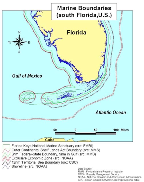
Generally under U.S. law, the individual states (in this case Florida, Georgia, North Carolina, and South Carolina) have control of the sea bottom and marine resources from mean high water out to the 3-nautical mile state-seaward boundary. Within this area, states have the authority to manage, administer, lease, develop, and use the natural resources of the ocean; the federal government retains considerable control over commerce, navigation, defense, fisheries, and international matters. Under section 8(g) of the Outer Continental Shelf Lands Act, states share nearshore revenues within 3 nautical miles seaward of the state-seaward boundary. Under the consistency provision of the Coastal Zone Management Act, states may also exert influence over federal activities that may affect any land or water use or natural resources of the state's coastal zone. This influence may extend through the Territorial Sea, which spans 12 nautical miles seaward from the shoreline (or 9 nautical miles beyond most federal-state boundaries), as well as within the EEZ, which may extend up to 200 nautical miles seaward from the shoreline (see figure 2).
|
| Figure 2. Marine regulatory boundaries and zones in south Florida, U.S. Note the overlapping complex geometries. |
In the U.S., federal and state agencies have a variety of overlapping authorities and jurisdictions. Some of the most important federal players include the U.S. Coast Guard (USCG), U.S. Environmental Protection Agency (EPA), U.S. Minerals Management Service (MMS), U.S. Army Corps of Engineers, U.S. Fish and Wildlife Service, and NOAA. This fragmented approach to management of ocean resources at the national level often results in redundant efforts, inefficiency, ineffectiveness, and lack of coordination among agencies with tangled, overlapping jurisdictions. Perhaps more problematic are the unidentified jurisdictional gaps in the existing governance framework that potentially can hinder effective ocean management and appropriate use, conservation, and protection of important ocean resources. These factors emphasize the need for the development of regional spatial frameworks such as the Ocean GIS, which will help make sense of offshore jurisdictional complexities. To be effective, the content and structure of a digital spatial database must address the important issues of ocean planning and governance and provide resource managers with a basis for assessing alternative management strategies and tactics.
Clearly, there is a need to sort out the policy quagmire, and GIS provides an excellent organizing framework for doing just that. The reality of the situation is that very few of the U.S. regulations were written with modern mapping technology in mind. It is not uncommon to find incorrect, imprecise, or inaccurate boundary coordinates published in the U.S. Federal Register and U.S. Code of Federal Regulations. Such instances may be the result of simple human error or misinterpretation of ambiguous legal language, or they may be the result of a lack of understanding of mapping principles. In other cases, the legal description may not adequately describe the geography or it may be extremely complicated to develop a mapping solution. In a paper cartographic world, the size and scale of the features portrayed on the map mask many of the spatial inaccuracies and uncertainties. Many times, fundamental cartographic concepts such as scale, resolution, spatial accuracy, datum, and projection are not considered. And because digital mapping technologies enable the development of precise maps, it is essential that those who develop policy understand these important concepts so that the resulting legal framework can be integrated into technologies such as GIS and the resulting map products are accurate.
Examples of mapping ambiguities include listing coordinates without reference to a vertical or horizontal datum, referencing ambulatory features such as the "wash of the waves at high tide" or "following the 100 fathom isobath," or using language such as "200 nautical miles from the baseline." In the case of this last example, is the correct boundary 200 miles over the surface of the earth, a chord projected through the earth, or some other interpretation? Many legal descriptions do not give complete information to accurately map the boundary and require the developer to be both cartographer and detective.
Offshore maritime boundaries are often referenced by their distance seaward from a baseline. A normal baseline is comprised of a series of points along the line of ordinary low water along that portion of the coast that is in direct contact with the open sea and is interpreted by the U.S. to be the same as the mean lower low water (MLLW) line (Thormahlen, 1999). However, because coastlines vary from smooth to deeply indented and are interrupted by bays and river mouths, and because the designation of offshore boundaries may confer significant economic rights, establishment of baselines is often complicated and contentious. A number of rule-based spatial determinations are used in such cases. These aid in establishing closing lines across the mouths of bays and rivers, and help determine the baseline status of islands or intermittently exposed features fringing the shore. The revenues tied to the resulting lines make each baseline point of extreme importance.
The financial consequence of baseline decisions is evident in the U.S. Supreme Court case of United States of America v. State of Alaska (1975), and the issue of "Dinkum Sands." At issue was whether this small formation just off the northern coast of Alaska qualified as an island with baselines from which a 3-nautical mile Submerged Lands Act Grant would belong to the state. Important oil and gas reserves were discovered nearby and both the U.S. government and the State of Alaska sought the right to grant leases for exploration of the area. After 17 years of legal action, the Court sided with the federal government, establishing its right to the $1.6 billion in oil and gas revenues. This illustration provides significant evidence that geography does matter.
A number of factors complicate the mapping of baselines. As with mapping all coastal and ocean features, the tidal influences on the marine boundary are considerable. The major complication with U.S. baselines is that there are at least two separate interpretations. Regulatory limits controlled by the Outer Continental Shelf Lands Act are under the responsibility of MMS and the resulting baseline that is negotiated between the states and the federal government can be fixed. Maritime boundaries controlled by the LOS are under the responsibility of NOAA and that baseline can correspond with the MMS baseline at the time of agreement but is ambulatory in nature and will shift with changes in the low water line (due to the natural processes of accretion and erosion). In other words, one baseline is used for determining offshore revenue sharing and the other is used for determining state, federal, and international jurisdictions. The result is two federal versions of the baseline used for generating different regulatory limits. The position of each line often depends on the placement of the other in relation to the baseline. Attempts to encode the baselines and the resulting boundaries can result in confusion for the geospatial data community.
Another example of regulatory and mapping complexity is illustrated in the legal description of many of the marine protected areas, such as those designated by the National Marine Sanctuaries (NMS) Act. Site-specific regulations are bounded by the extent of each sanctuary and are designed to protect, preserve, and manage specific marine resources. Unfortunately, the high quality regulatory framework for this act is accompanied by a less-than-adequate spatial component.
In the case of the Channel Island NMS, there is the additional designation of a national park managed by a separate federal agency. Channel Islands National Park of the U.S. National Park Service (NPS) has exclusive jurisdiction over the islands (land) and shared jurisdiction with the NMS managed by NOAA and the State of California's Fish and Game Department from mean high tide out to 1 nautical mile (water). NOAA has total jurisdiction from 1 to 6 nautical miles. Within the 1-nautical mile buffer, NPS manages that area of the water above the depth of 1 centimeter while NOAA manages the area below a depth of 1 centimeter. Not only is the term in the legal description "mean high tide" not an actual tidal datum, but also the inclusion of a vertical (1 centimeter along the surface) jurisdiction requires that the representative cadastral boundary be three-dimensional. This example is complex to understand and map and even more complex to manage with regard to the resulting institutional responsibilities.
Another mapping problem can be highlighted as other NMS descriptions are examined. In the case of the Hawaiian Islands Humpback Whale NMS, the legal description uses terms such as "excludes the areas within 3 nautical miles of the upper reaches of wash of the waves." The Monterey Bay Marine NMS designation states "excludes small areas of cities." Other examples of NMS mapping ambiguities include listing coordinates without reference to a horizontal or vertical datum; referencing natural landmarks; designating a depth isobath as a seaward limit; and citing ambulatory features such as mean high water, river mouths, and the mean low water line.
Another example is the set of demarcation lines that have been established by the Convention on the International Regulations for Preventing Collisions at Sea, 1972 (commonly called COLREGS). COLREGS define boundaries across harbor mouths and inlets for navigation purposes. If a vessel is landward of the COLREGS line, it must adhere to the Inland Rules of Navigation established under the Inland Navigation Rules Act. Seaward of the COLREGS line, vessels are subject to rules of navigation established by the International Regulations for Preventing Collisions at Sea, as amended. Historically, the COLREGS lines have been established by drawing a line across a harbor mouth on a paper nautical chart. In addition, geographic references that position these lines are published in the U.S. Federal Register. However, these references typically include no coordinates and often reference ambulatory or ephemeral geographic or manmade features. The georeferencing methods used to describe the location of the COLREGS line are all too often insufficient for use within a digital mapping environment. For example, the following language is used to describe a section of the COLREGS line running from Tybee Island to St. Simons Island, Georgia.
A line drawn from the southernmost extremity of Savannah Beach on Tybee Island 255° true across Tybee Inlet to the shore of Little Tybee Island south of the entrance to Buck Hammock Creek. (U.S. Department of Transportation, 1995)
From a digital mapping perspective, there are several problems inherent in this approach. For example, beaches are extremely dynamic natural features. Hence, the southernmost extremity of Savannah Beach may shift from storm to storm and year to year. As it does so, a heading of "255° true" may cease to connect the line with the intended location. Furthermore, the reference to the other end of this line segment, "the shore of Little Tybee Island south of the entrance to Buck Hammock Creek," is geographically vague in addition to the fact that it references another ambulatory feature. Finally, no coordinate information is provided that would allow a GIS technician to create a precise and legally accurate map of the COLREGS line.
As evidenced by these few examples, creating actual digital spatial map layers for use in a GIS is often problematic. In many cases, the legal description of the boundaries may not adequately describe the geography or it may be extremely complicated, requiring subjective interpretation. New legislation and regulations must take into consideration the state of mapping technology. Ideally, the policy regime will list the bounding coordinates and metadata (e.g., datum) with enough precision to adequately create the spatial data layer. Removing the ambiguities is a necessary component to reduce uncertainty for resource analysis such as may be done in GIS applications.
This effort to outline the policy framework is part of an ongoing project to develop an Internet-based ocean governance and management GIS to facilitate the shift in the U.S. from fragmented management of individual ocean resources to a more integrated, region-wide management approach. The Ocean GIS web site was developed utilizing HyperText Markup Language (HTML), Environmental Systems Research Institute's (Esri®) MapObjects™ Internet Map Server in conjunction with Visual Basic®, and JavaScript. Major features of the site include an interactive mapping application, marine and coastal spatial data and download tools, associated metadata, and legal summary pages, all designed to support regional ocean management.
The project is targeted at the individual southeastern coastal states and allows the ocean resource manager to examine the significant issues and data of the region in conjunction with the supporting text that describes the laws. The system supports analysis from a particular area of regulated interest, such as marine plastics disposal, or from spatial analysis such as a particular geographic location (e.g., point on the map). Standard GIS functions are supported, such as view, change layer, pan, zoom and query. The unique element in this project is the linkage between the policy and its geography. Each applicable data layer contains an attribute link to the appropriate legislation. This allows the user to click on the map area and be presented with the legislation or agency information associated with that particular point. The flexibility of Internet mapping technologies allows the user to successfully "drill down" to the level of detail needed to satisfy the analysis. For example, the user can look at the attributes of a feature or list the names of the federal regulations related to the point. They can pick a particular act and look at a synopsis of that legislation or they can link to the actual U.S. Code of Federal Regulations for more information.
Spatial analyses of ocean policy can provide an important component in balancing the conflicting uses of resources that are occurring in our planet's oceans. Tools such as GIS can help policy makers identify gaps and overlaps in regulations. These types of decision support tools can lead to better management decisions and more integrated ocean management strategies. In order to conduct the necessary analyses, spatial deficiencies of policy and management regimes must be identified and addressed. New regulations must consider the state of the technology and adequately describe the geography under consideration. Where possible, federal agencies must clear up ambiguities in legal descriptions. The Ocean GIS prototype is an example of what can be accomplished when these spatial components are in place. The Ocean Planning and Governance GIS web site can be accessed at http://www.csc.noaa.gov/oceangis/.
National Research Council (NRC). 1997. Striking a Balance: Strengthening Marine Area Governance and Management. Washington, DC: National Academy Press.
Shalowitz, A., 1962, Shore and Sea Boundaries, (Washington, DC: U.S. Government Printing Office).
Thormahlen, L., 1999, Boundary Development on the Outer Continental Shelf. U.S. Department of the Interior, Minerals Management Service, Mapping and Boundary Branch, Technical Series Publication, MMS 99-0006.
United Nations, 1983, The Law of the Sea: The United Nations Convention on the Law of the Sea with Index and Final Act of the Third United Nations Conference on the Law of the Sea. (New York: United Nations).
U.S. Department of Transportation, U.S. Coast Guard, 1995. Navigation Rules, InternationalľInland. COMDTINST M16672.2C (Washington, DC: U.S. Government Printing Office).